Wednesday, November 30, 2022

Cold Weather arriving. Polar vortex on the way

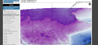
 Welcome back to Winter Wonderland in southern Manitoba, the snow is on the ground, the windchill is high and the roads are icy. For those thinking that summer would stay, unfortunately as the tilting of the sun and rotation of the earth winter has to come. Well the reality of it is you can thank this cold weather due to a polar vortex that is beginning to sink south over the Canadian prairies. That is detailed below in probably one of the coldest temperature values I have seen in a very long time, that below is on Friday afternoon 🥶🥶🥶. Find out how cold it will get and what we can expect weather wise, in southern sections of Manitoba. 


Tonight: We will be sitting on the edge of an arctic high pressure system as we experience a northwesterly flow aloft our temperatures tonight will be cold, crisp and arctic like. A good majority of our region will see overnight lows in the mid to high minus teens, with windchill values in the mid to high minus 20’s if you are in the Swan River and Assessippi Provincial park regions chances are windchills could be approaching minus 30C. Very little in the way of cloud is expected over all regions tonight. 


Extra Feature: 

This is one of those well known facts that the polar vortex becomes a yearly occurrence, the above image is a model run image of the polar vortex that is expected to impact a large portion of Canada next Tuesday. The arctic and the northern part of the United States. It will likely have impacts on our weather pattern over the next couple of weeks. Don’t worry; the polar vortex has been around for centuries but only has been brought into the mainstream recently thanks to the media bringing attention to it a few years ago. It is usually mainly over the arctic but it recent years it’s been displaced by warming in the stratosphere. Read more on the polar vortex here: https://www.weather.gov/safety/cold-polar-vortex I am seeing signs of a pacific push of air over western Canada come mid to late December, we’ll see if this verifies. 

Thursday: For those wondering about some milder temperatures, Thursday is pulling I guess a winter prank. A low pressure system will be skirting the USA border and with that it will bring in a batch of cloudcover, there will be some periods of sun mixed in. So sun and cloud likely on the day. Temperatures will warm up and they will turn out milder than all of this past week, high values will rise into the mid to high minus single digits. Windchills may feel slightly colder than that. In the evening hours a batch of snow and light snow will likely develop in southwest Manitoba. 

Thursday night: A low pressure system off to the south of us will pull in a cold arctic airmass as we sit on the north side of the low, a good chance of snow on the backside will likely bring 3-5cm. Depending on the intensity there will likely be some heavier bands but brief. Temperatures on Thursday night will stay mild in the southeast with temperatures in the high minus single digits, and areas just west of Elie seeing values in the low minus teens. Windchills will only be in the low minus teens in the southeast further west with values in the mid to high minus teens. Further north in the parklands a higher chance of values in the low minus 20’s. A large area expected to see snowfall, regardless of temperatures. 

Friday: Remnants of the low pressure system will move over southern Manitoba before going into Ontario in the later half of the day . Temperatures will only get colder behind an arctic cold front that will be sitting over the Canadian prairie provinces snow will begin to taper off towards the late morning hours to early afternoon. High temperatures will only be reached in the late morning to early afternoon hours in the low to teens for most. However most of the temperatures will drop by the late afternoon well into the mid to high minus teens by evening most of our area will be seeing wind chill values well into the mid to high minus 20’s, before dropping close to -30C (I mean -26 to -29C ) for a large majority of the south. Frostbite will be possible in minutes. 

Friday Night: Clearing will be likely with a majority of temperatures dropping well into the high minus teens to low minus 20’s. Windchills will likely sit well into the high minus 20’s and low minus 30’s. This is the kind of cold that can cause frostbite and becomes dangerous if skin is left exposed. Please dress warmly and stay indoors if you can. 

The Weekend: Another day of sunny skies is likely on Saturday. As well another batch of snow is likely on Sunday with about 1-3cm likely. Temperatures will warm into the high minus single digits closer to -10C on Saturday. Saturday highs should be stable and sit in the mid to high minus teens, Saturday night lows will rise into the low to mid minus teens, as snow builds in. Sunday will see similar temperatures with most areas seeing highs in the low to mid minus single digits. Warmer than earlier in the week. That cold builds right back in overnight well into the mid to high minus teens, areas in the inter lakes and parklands will see values well into the high minus teens with windchills in the minus 20’s. 

Enjoy the rest of the week and the weekend. -Mike 

Wednesday, November 23, 2022

Warm Second Half of The week ahead


Much of southern Manitoba is in store for some warmer weather as we head into the second half of the week, southern sections of the province can expect to see temperatures in the range they would be in early spring. See that low pressure system above?? That warm front and low pressure system will be the one providing us with a nice warm up. However that could change for us as we head into next week. 

Looking at a much shorter blog for this post, much of our region can expect a varying amount of warmth on the day Thursday with high temperatures soaring into the low to mid single digits on the plus side, some sun and cloud  and some areas in the inter lakes seeing high temperatures in the low minus single digits or around 0C. If you are looking for the warmth, the real warmth comes in on Friday. The temperatures on Thursday night will bottom out in the mid minus single digits before rising overnight into the morning to the low minus single digits. 


Friday (Above): a much warmer day is on tap with areas in the extreme southwest at a chance of seeing high temperatures in the 10-12C mark, with areas further east in eastern and central Manitoba have a lower chance of that with highs only reaching the low to mid to even high single digits but this warmth will spread north into central Manitoba. Friday night: Temperatures will remain on the mild side staying above the freezing mark with temperatures in the low plus single digits. The weekend will be equally mild with high temperatures in the low to mid single digits and overnight lows in the low to mid minus single digits, with Sunday night seeing lows in the high minus single digits. 

Next week: another round of snow is possible with cooler temperatures as we get impacted by the north side of a Colorado low. 


Friday, November 18, 2022

Cold Start to the weekend with a Gradual Warmup

 Much of southern sections of Manitoba is in for a calm weekend weather wise ; except for a large swath of snow that will move through southern archons of Manitoba on Saturday evening. At the moment there are snow squalls coming off of lake Winnipeg, there is narrow bands of it occurring at the moment. What I’m looking at this weekend is a warm front moving through southern sections of Manitoba on the evening on Saturday, on the east side of it temperatures will sit in the low to mid to high minus teens on Saturday in south central and southeastern Manitoba with areas in southwestern Manitoba warming into the mid to high minus single digits.


On Saturday night a band of snow will move through southern sections of Manitoba bringing with it a brief, but heavy band of snow along with it. A good chance of  3-5cm is likely with snow and blowing snow, travel isn’t advised on highways in reduced visibilities on Saturday evening.  Temperatures on Saturday night will drop into the low to mid minus teens. On Sunday a much warmer airmass will filter into our region, thanks to a westerly flow developing over our area this will definitively mark the beginning to a longer stretch of warmer weather. Sunday high temperatures will rise into the low to mid minus single digits with overnight lows in the high minus single digits on Sunday night. This warmer weather pattern will continue into the week with high temperatures in the low to mid minus single digits, and overnight lows continued in the low minus teens and high minus single digits.

Thursday, November 10, 2022

Snow storm to impact southern Manitoba over the next 24-36 hours, cool weather to follow.

 Much of southern Manitoba looks to get impacted by a snowstorm heading into Friday, a lot of northern North Dakota including some regions of southeastern Manitoba has been experiencing heavy snowfall in the Sprague, northwest angle, and the southeastern sections of Manitoba. Unfortunately impacts look like they are going to stay with us into remembrance day. Find out when and where the heaviest impacts will occur, and what you can expect for the rest of the weekend. 


Forecast snowfall and storm system location around 3am local time. Snowfall forecast graphic is below.. 

Tonight: A strong powerful low pressure system will sit over northern North Dakota tonight dropping upwards of 20 to 40cm of snow over northwest North Dakota, and impacts extending into southern sections of Manitoba. Areas of southwestern Manitoba, the parklands, the interlakes, and western Manitoba will likely escape the snow itself. Snow has already begun and it will persist into the next 24-36 hours, cloudy skies are likely overnight with snow and winds gusting to 40 to 60km/h out of the northwest resulting in reduced visibility Highway travel isn’t recommended. Even within city limits visibility may be down to zero at times.


Generally 15 to 25cm of snow will likely fall along the American border in south central Manitoba into the pembina valley, areas along the edge from southwestern Manitoba into Winnipeg , the red river valley and eastern Manitoba will see 10 to 15cm of snow possibly. Overnight low temperatures will likely drop into the low to mid minus single digits, some areas may feel colder in the low to mid minus teens with the windchill in the interlakes and western Manitoba on the edge of the snow . Areas in eastern Manitoba will see low windchills in the low to mid minus teens. 

Friday: Snow should begin to taper off by the morning, with a lot of local blowing snow continuing through the  afternoon. There will be a chance for flurries through the afternoon with mostly cloudy skies expected, except the interlakes regions where sunny skies are likely. unfortunately because of the snowfall overnight temperatures will struggle to rise above freezing. Highs in the day Friday will rise into the low to mid minus single digits, windchills likely sit just around -10C to slightly above around -11 to -12C. 

Friday Night: High pressure will likely move in and that’s when we are likely going to see some of the coolest temperatures overnight that we have seen since last spring. Temperatures on Friday night will drop into the high minus single digits and some areas could see wind chills in the low to mid minus teens, around -10 to -15C especially in western Manitoba where the coldest windchills will be. . 

Saturday and Sunday: High pressure looks to build in and this weekend calmer weather likely as well, Saturday expect a mix of sun and cloud with high temperatures in the mid minus single digits. Wind chills will likely sit in the high minus single digits and low minus teens. Saturday night will see increasing clouds. Overnight lows will stay on the mild side as cloudy skies keeps the warmth in and acts as a blanket, which will end up resulting in lows in the high minus single digits with windchills in the low minus teens. Sunday will see a chance for cloudy skies and high temperatures in the low to mid minus single digits, also it looks like windchills will be in the same range. Sunday night a chance for flurries is likely and low temperatures will drop into the high minus single digits with some areas around the red river valley seeing lows in the low minus teens. A good chance of seeing similar windchills on Sunday night in the low minus teens and high minus single digits.  

Saturday, November 5, 2022

Cold and slightly unsettled weekend Expected

 Much of southern sections of Manitoba has experienced a fairly warm fall that has featured temperatures in the mid to high teens the past few weeks. Some days during the past few days seeing highs close to 20C, in November that is highly unusual.


Over the weekend we can expect to see a low pressure system (above) on the day Saturday to move through bringing in a slightly warmer airmass. Temperatures on the day Saturday will soar into the mid to high single digits, later a low pressure system will move in bringing a swath of rain and snow. Areas from the parklands south can expect rainfall, with most snow happening north by the Swan River regions. Snow with rain mixed will then quickly move through the rest of the south after 6pm.  There’s a good chance that this will clear out by the late evening early overnight period. Saturday night cold weather will filter in with a good chance of cloud cover clearing out. Low temperatures will drop into the low single digits in the southeast and south central  with the areas in the southeast seeing lows in the low minus single digits. Sunday the low pressure system as mentioned will move into Ontario , behind it a cold air mass will move in bringing another round of snowfall into southern regions.


Most of the area will see amounts of 5 to 10cm, except areas in northern Manitoba where upwards of 20cm could fall in NW Manitoba. Temperatures on Sunday will rise into the low minus single digits in southern ‘Manitoba areas in the north interlakes will see highs in the low single digits. Also poor visibility and snow and blowing snow is likely to occur in western portions of Manitoba. Travel isn’t recommended. Sunday night will likely be the coldest with overnight low temperatures dropping into the high minus single digits and low minus teens in the western half of Manitoba, along border regions. Elsewhere expect lows between -4C and -9C. Windchills might be colder than -10C in some areas.  

The week ahead: Temperatures will remain cooler than we have seen lately, with the likelihood of most areas seeing highs in the low to mid minus single digits on Monday with a swath of snow coming up from the states along a warm front overnight into Tuesday, lows on Monday night will likely warm as a warmer air mass arrives. Lows will sit around the zero degrees to low minus single digits.  Another cool day will arrive on Tuesday with highs in the low single digits in south central, southeast and parts of the southwest seeing those temperatures. Areas elsewhere in the west will only see highs in the low minus single digits. There’s a good chance of more rain and snow just still have to wait for more model data to determine where the heaviest amounts will fall. There will be the possibility of thunderstorms as mentioned by Dan Riddle from NWS Grand Forks. Whether they happen will depend on how far that warmth moves. Regardless we have some interesting weather ahead for the coming week. 

Featured Post

Major Rainfall first of the season for Southern Manitoba.

Hello folks of southern Manitoba this is another weather update, we have some interesting weather on the way a low pressure system developin...