Friday, December 31, 2021

Extreme Cold Weather Sticks Around

 I just want to wish you all a belated merry Christmas and a happy new year, I know I haven’t been on here in about 2 weeks time. I have had a lot of things happen over the holidays, spent time with family and got some really nice gifts. Overall My hope is that I can keep you all updated on weather events throughout the new year. May 2022 bring good things to you all and for the Christian’s out there may God give you a wonderful year. 


(Above: A very cold airmass will sit over the region over the next few days, that area of purple is a polar vortex sitting over the Canadian prairies).

As for our weather over the next few days into the new year and our weekend ahead, it’ll definitely feel like winter. A arctic area of high pressure has begun to settle into our area, it’s also a part of a polar vortex broken off that is moving through the prairies. This will lead to some of the coldest temperatures we have seen in a long time. Read more and Find out how cold it will get and find out how long this will last for. 

Friday Night: Clear skies and a arctic airmass sitting over the region will aid in temperatures dropping well into the low minus 30’s for a majority of the region,  from -30 to -34C with the coldest lows happening in the red river valley and sections of southwestern Manitoba closer to -35C. Much of the windchill values will exceed -40C, with values from the low to high minus 40C range. The coldest of the values will be sitting right over top of southwestern Manitoba where low windchills could get as cold as -47C. Keep in mind the low temperatures will be reached shortly before sunrise around 8am. 

Saturday: Will end up being super cold in the morning hours, as previously mentioned. A small system will move through central portions of Manitoba during the afternoon bringing a chance for some flurries by Dauphin regions, and along with this some light cloudcover. Temperatures will soar into the low to mid minus 20’s for all regions (-20 to -26C) with some places a degree or 2 colder if your in southwestern Manitoba. Windchill values will exceed minus 30C with a majority of the region seeing windchills in the low to high minus 30’s (-31C to -38C). The coldest of the values being felt in the parklands towards southwestern Manitoba, over the Manitoba lakes and portage la Prairie regions.

Saturday Night: An area of high pressure will move east southeast in the northern states the good news is that it will start ushering in a slightly warmer airmass, temperatures will not be as extreme as they were on Friday night. However , we’re still going to see some fairly low temperatures in the low minus 30Cs (-30 to -34C), windchill values will only drop into the low to mid minus 30’s in the southwest and the southeast. Areas in the red river valley can expect to see low windchill values in the -36 to -40C range. 

Sunday and Sunday Night: Some good news is that a warm front will approach the region as a clipper system of the sorts forms over the Rockies and drifts eastwards, ahead of this warm weather will start moving into the area. Cloudier skies are likely, with the chance of some flurries mainly in the afternoon . Temperatures on Sunday will rise into the low minus single digits in the southwest and western half of Manitoba (-10 to -14C). Areas further east like the white shell and the red river valley will see highs rising into the mid to high minus teens (-15 to -18C). Windchill will still be a factor where the high minus teens and low 20’s (-15 to -22C) is a possibility for the western half of Manitoba and eastern Manitoba seeing mid to high minus 20s (-22 to -28C). Cloudier skies are likely on Sunday night, Overnight low temperatures on Sunday night will warm well into the mid to high minus teens (-14 to -18C), with some areas out towards Dauphin seeing lows a few degrees below minus 10C. Unfortunately if your looking for spring warmth you won’t find it, windchills will still drop below -20C (-20 to -25C) in the southeastern half of Manitoba, the red river valley into some patches of southwestern Manitoba and the interlakes. Areas elsewhere will only see moderate windchills in the mid minus teens to the high minus teens (-14 to -19C). 

The beginning of the week: The forecast gets a bit tricky, southern sections of Manitoba and the province itself will be affected by another area of low pressure the question is how much of an impact it’ll have on our area. Current model guidance is only suggesting a brief batch of snowfall with max of 5cm. Temperatures will remain quite mild with highs on Monday in the lower minus teens (-10 to -15C). Windchills still sitting in the upper minus teens (-15 to -20C). A much colder batch of arctic air will filter in on Tuesday and Wednesday with highs in the mid to low minus teens and lows in the high minus teens, windchills of minus 20 to -35C are also possible. It will not be as severe as it was on the weekend. 


Happy New Year!!!


Wednesday, December 15, 2021

Cold winter weather, makes a return.

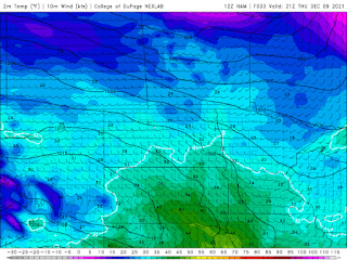
 Much of Southern sections of Manitoba has been experiencing, a unseasonably warm last couple of weeks. A low pressure system will continue moving through our region causing a shift in the temperature pattern, and It’ll likely cause a return to below normal temperatures as arctic high pressure builds in. (Below: A snapshot of what temperatures are expected for the day on Thursday, plummeting well into the minus teens). 

Wednesday Night:A area of low pressure will be off to our south and as it moves east snow will follow on the backside of this low pressure system. 


Unfortunately before that happens there will be a risk of freezing drizzle during the first half of the evening before , snow and blowing snow will take over for the southeastern half of Manitoba regions. The blowing snow will cause very poor visibilities especially in open areas, highway travel isn’t advised. Freezing drizzle accumulations will only end up being a trace. Snowfall should start easing late overnight, early morning. Snowfall should only total 2-4cm, as well there is freezing drizzle advisories  in effect at the moment for the southeastern half of Manitoba read them here.    Heading into the overnight behind this system very cold arctic air will begin filtering into the region, snow and blowing snow coupled with a northwesterly flow will allow temperatures to drop well into the mid minus teens, to high minus teens (-15 to -19C) windchills will drop well into the mid to high minus 20’s (-25 to -30C). 

Thursday: Will end up starting off with snow and blowing snow in the southeast before clearing in the late afternoon hours. It’ll end being one of the coldest days of the week, temperatures will only warm up into the low to mid minus teens (-10 to -15C). Some cloud will filter in during the afternoon. Overall windchills may end up being in the minus 20’s again in the afternoon. Thursday night, will end up being cold again, temperatures will drop well into the mid to high minus teens (-15 to -20C). Windchills anywhere from (-25C to -32C) overnight but will moderate by Friday morning as cloud starts filtering into the area. 

Friday: An approaching low pressure system will move into the region, bringing cloudy skies with snow likely coming in during the early to late afternoon hours with a clipper bringing 5 to 10cm. Blowing snow is also possible. Temperatures will moderate a bit during the day being in the low to mid minus teens vs the mid to high minus teens of earlier week. So I would expect highs to be anywhere from -13C to -16C in the west to -10 to -14C in the southeast with windchills in the high minus teens and low minus 20s. Friday night: The snow and blowing snow will taper off during the early evening hours into the early overnight. Cloudy skies are likely , that’ll help keep temperatures steady in the low to mid minus teens in the southeast (-11 to -16C), areas in the southwest unfortunately will see lows from (-15 to -21C) and corresponding windchills in the low minus 20’s to the low minus 30’s, on the colder side in the southwest.

The weekend: Will end up being much colder , a arctic high will filter in behind the low pressure system and temperatures will only warm into the high minus teens and low minus 20’s. Overnight lows on Saturday will sit over the low to mid minus 20’s with windchill exceeding -30C. Calm weather is expected Sunday with highs in the mid minus teens, even near -10C along the USA/Canada border. Then as we head into the overnight lows will approach the mid to high minus teens. Colder weather is possible on Monday, however that’s a ways out still. 


Wednesday, December 8, 2021

Warm Weather makes a comeback.

 Much of southern Manitoba will be getting a return to warmer weather, all thanks to a warm front moving into southern sections of Manitoba today. There will be a longer period of warmer weather, thanks to a westerly flow with slight ridging occurring. Find out how long this will last for and how warm it will get. 

(Above):Warm day ahead for Thursday, temperatures getting close to zero degrees for the day. Temperature unit is in Fahrenheit. 

Wednesday: Much of southern sections of the province will deal with cloudy skies during the day , a band of snow will move into the region this late afternoon with a warm front as it moves in. It’ll end up bringing light snowfall with periods of blowing snow. Accumulations will vary between 2-7cm. Temperatures will warm up around the high minus single digits (-5 to -10C) for areas along and south of the Trans Canada highway , areas further north will still have to contend with daytime high temperatures in the low minus teens (-10 to -15C). Wednesday night: Snow should end this evening , then Cloudy skies should dominate the pattern , with a chance of flurries in the south central and southeastern sections. Temperatures will take a boost thanks to a southerly flow establishing itself as a high pressure system moves eastwards, and we end up on the backside of it. Temperatures will warm (Weather joke here: Temperatures they won’t be taking a energy drink , although it will sure feel like it 🤣🤣🤣) up well into the mid to low minus single digits overnight (-7C to -3C). 

Thursday and Friday: Much of southern sections of Manitoba can look forward to warm weather, temperatures on Thursday will soar well into the mid to high single digits (-1 to -6C). Sunny skies are also likely as well which will help it feel a little warmer. Temperatures on Thursday night will drop into the low minus teens (-10 to -15C). Friday will be much of the same where high temperatures will rise into the mid to high minus single digits (-5 to -10C) for the day. Heading into Friday night much of the region will unfortunately see lows dipping quite a bit, as a high pressure system sits over the western mountains in the states, giving us a cool northwesterly flow. Temperatures will drop into the low minus teens to the high minus teens. (-10 to -19C). Only the warmer temperatures in the low minus teens will be in the southeast, everywhere else will see the chills of winter. I’m sure the windchills will end up in the minus 20’s overnight. 

Weekend Details: Sunny skies are expected through the weekend, another low pressure system will swing through on Saturday and Saturday night. We won’t be expecting any impacts from this system as it moves in. Temperatures will once again hit the high minus single digits to the low minus teens on Saturday (-7 to -12C). Saturday night temperatures will rise into the mid to low minus single digits (-2 to -5C) as the warm front moves in. Temperatures will really end up being on the upswing, Sunday when high temperatures will rise into the low to mid plus side of the single digits (1 to 5C). I was looking over some of the record temperatures and record high temperatures look attainable on Sunday if it gets anywhere over 1C. However because of the sun angle not a lot of melting will take place. This is bizarre for December to say the least. I am seeing the possibility of frigid overnight lows in the low minus teens to high minus teens on Sunday night about -13 to -16C. You can thank this to a cold front swinging through in the evening on Sunday, it might end up bringing a chance for flurries but we’ll know more on the Friday update .

-Mike McGregor 


Saturday, December 4, 2021

Blizzard conditions Sunday give way to extreme cold weather 🥶

 This blog will be shorter than other blogs I have done but will still have some detailed information. 


Southern Manitoba will be impacted by a low pressure system over the next 24-48 hours, this system will likely end up bringing southern Manitoba about 5-10cm especially with areas along the border, with the possibility of lesser amounts as you go northwards where 2-4cm is likely. The majority of the snow is expected in the morning to early afternoon hours, flurries are also possible into the evening hours. During the late morning a blizzard will develop south of Winnipeg where snow and blowing snow is expected, where winds will be between 30 to 50km/h. Gusts up to 70km/h or more are likely, this will persist shortly after midnight. 


For the areas north of the winkler and Emerson region, the winds won’t be quite as strong in the rest of southern Manitoba during the afternoon. In the evening much of the regions will see gusts up to 70km/h. Behind it a arctic airmass will filter in,, unfortunately a cold arctic air mass will filter in behind this system. Flurries will taper off shortly after midnight. I’m looking at temperatures falling well into the minus 20’s, overnight into Monday. Windchills will fall anywhere from -29 to -38C. 

Heading into the work week Monday-Wednesday: 
Temperatures will remain well below there seasonal averages, with partly cloudy skies and some sun mixed in. We will likely end up seeing some of the coldest weather of the season yet. Temperatures for daytime highs will remain in the low minus 20’s and mid minus teens, with overnight lows well below -20C. A more informative update will arrive on Wednesday.

Stay Warm! 

-Mike McGregor

Wednesday, December 1, 2021

Unseasonable warmth arrives, unsettled weather to follow

 Much of southern Manitoba has been seeing normal temperatures and bouts of freezing rain especially in the red river valley. This trend has fortunately come to an end, there appears to be a brief warmup on the way for the region with some unsettled weather expected. Unfortunately we will be missing out on the near 20C temperatures expected south of the border in North Dakota and Montana, unusual to say the least for them. 

(Above) Wednesday will end up being the warmest of the week, temperatures as warm as 6 to 8C will be likely across the south. Maybe even over 10-20C south of the border). 

Wednesday: A warm front with a attendant low pressure system will be approaching the region with a chance that by the late morning and afternoon hours a batch of snow, freezing rain, and rain will all accompany the warm front. Snowfall accumulations are only expected to be between 1 to 5cm. This weather is expected to reach eastern Manitoba and Ontario by early to mid afternoon. Cloudy skies are likely for the afternoon hours with a small chance of showers in the afternoon hours. Temperatures will warm above zero for a good portion of the region, highs will end up sitting in the low to mid single digits (1 to 8C) for the afternoon. Wednesday Night: Heading into Wednesday night a arctic cold front will swing south along with it, partly cloudy to mostly cloudy skies can be expected. Temperatures will drop into the low to mid minus single digits, the warmest of the lows can be expected in the southwest but colder as you move north and east into the interlakes and the rest of southern Manitoba (-1 to -5C). 

Thursday: A warm front will be approaching much of southern Manitoba and ahead of it some cloudy skies are likely, a high pressure system will start sinking south into the region we’ll be on the west side of it. Theres a small chance for flurries during the day as well. Temperatures during the day will soar into the mid to high minus single digits (-1 to -7C) with temperatures not getting any colder than -7C. Thursday night: A low pressure system is expected to travel through northern and central Manitoba, snow is expected there with the potential to drop as far south as Gimli. Areas along the border have a small chance of getting a brief flurry or shower as a stationary front moves into areas of south central Manitoba. Clearing skies are likely on Thursday evening with clear skies on Thursday night. Temperatures will stay warm overnight with lows only sitting in the mid to high minus single digits (-4 to -9C). 

Friday: The low pressure system that I mentioned on Thursday night will move into Ontario by Friday afternoon, with a cold front draped over northern Manitoba. A high pressure system will sit off to our south in North Dakota.  A slight chance of flurries can be expected as a northerly flow develops. The best chance for flurries appears to be off of the Manitoba lakes. Mostly cloudy skies can be expected in the south central and southeast regions. Sunny skies are expected elsewhere. Temperatures in the lower minus single digits can be expected (-1 to -5C). Friday night: Increasing clouds are likely ahead of a developing low pressure system in the northwestern united states. Temperatures will drop to the upper minus single digits (-5 to -10C). Areas in the interlakes will see lows in the low teens (-10 to -14C). 

The weekend: Much of the same can be expected with the exception being a possibility of snowfall on Saturday night into Sunday, too early to determine snowfall amounts for this system quite yet. Temperatures will fluctuate highs on Saturday will end up being in the upper minus single digits on Saturday (-5 to -10C), overnight lows much the same the exception being in the escarpment and dauphin regions where they may drop into the low minus teens below -10C to as cold as -15C. Sunday will be difficult,, temperatures might drop quite a bit after reaching there daytime highs in the early afternoon around the mid to high minus single digits before dropping into the low minus teens. Overnight temperatures will be significantly colder and it’ll be the end to the warmth we’ve been seeing with lows possibly into the low minus teens to near minus twenty Celcius. We will keep you updated if the models continue to signal snowfall and the cold temperatures. 

Next blog post comes in on Saturday. Have a good rest of your week. 😊😊😊. 

-Mike McGregor

Featured Post

Major Rainfall first of the season for Southern Manitoba.

Hello folks of southern Manitoba this is another weather update, we have some interesting weather on the way a low pressure system developin...