Sunday, January 29, 2012

Warm Weather Continues with Some Snow Tonight!

We had another beautiful day today, with temperatures hovering right around normal, even though it felt cold. The nice weather this evening across SE MB will give way to heavier clouds by around 6pm, and then a band of snow should make it's way across the southern part of the province this evening and overnight ahead of a warm front.(See Picture on left from NOAA). Blowing snow may become an issue in open areas tonight with the snowfall as winds will be 50 gusting to 60 km/h from the south so prepare for reduced visibility at times. As for snowfall amounts they won't account for much at the most 2 to 4cm can be expected across most parts of southern Manitoba. The snow will clear from our region late tomorrow morning welcomed by cloudy,damp and mild conditions for the rest of the day.


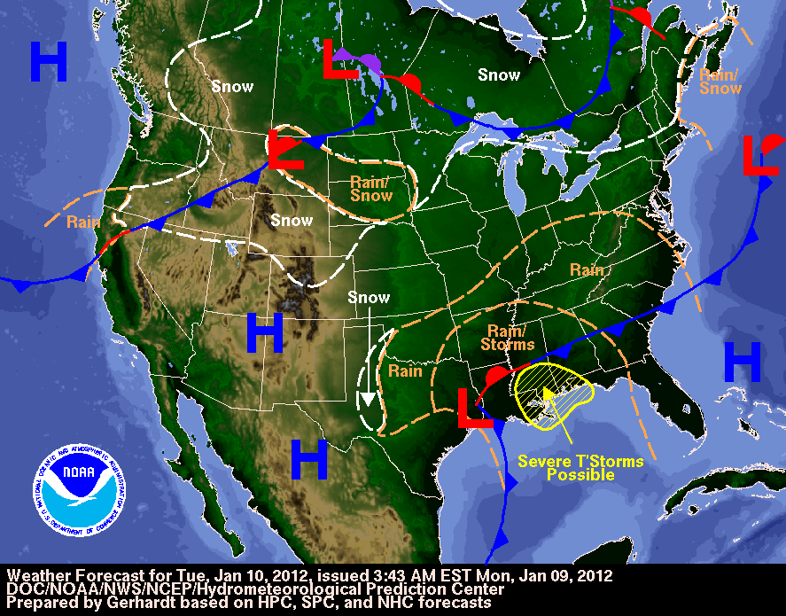
As for Tuesday we will see the arrival of another low pressure system that will come from SE Saskatchewan and move across our area bringing with it equal chances of rain,freezing rain,and snow (see the picture on the left). I don't quite yet know for sure which areas will receive what precipitation, but at best according to the latest GFS run, areas south of Winnipeg could see freezing rain, while areas just on the south edge of the city could see sleet. Areas like Winnipeg and north of Winnipeg could see snow.Overall we will definitely see some kind of precipitation over the south part of the province on Tuesday. I will know more by tomorrow evening. 

As the month ends, we may tie for the 2nd or 3rd warmest January on record, all because of our warm weather. For the first few weeks of February looks like the mild weather with little or no snowfall is expected to continue.

Saturday, January 21, 2012

Finally the End of our deep freeze!

 What a week it has been! Temperatures were well below normal from (-20 all the way to -40C )for quite some time. Now we can expect a change to more seasonal weather as we see some low pressure systems pass over our area that will bring with them light snowfall and a chance for mixed precipitation, with warmer air from the SW ahead of them. Although, we still will have some time periods during the next several weeks where we will see arctic air invade our region as low pressure systems pass by us, the temperatures will rebound quickly if any cold air invades. If you are wondering if we will see any cold weather over the next few weeks, chances are slim as the worst of the cold air will be directed down into Extreme Southeast Manitoba and most of Ontario. We will be on the very edge of the arctic air.

Canadian Government Invests $78.7 Million Dollars Towards Weather Monitoring Systems

As of January 20, 2012 Environment Minister Peter Kent announced that the Harper Government will be investing $78.7 million dollars over the next few years to increase the capability of weather monitoring systems making sure Canadians get access to world class weather data."This investment in Environment Canada's weather monitoring infrastructure will result in improved weather forecasts and warnings to better protect Canadians."The upgrades will help strengthen the Department's weather monitoring networks including the weather radar network, which is the part of Canada's severe weather warnings service that has been there for 40 years. The upgrades will also modernize the monitoring infrastructure and help Environment Canada keep up with the rapid evolution of new science and technologies.

The Areas that will be upgraded are as follows:
Canadian Weather Radar Network ($45.20 million)
Canadian Weather and Climate Observing Networks ($18.80 million)
Canadian Aerological Network ($4.20 million)
And the Canadian Lightning Detection Network ($10.50 million)

This new funding complements the Meteorological Service of Canada's ten-year strategic plan that addresses critical infrastructure, scientific advancements, life-cycle management strategies and important services delivered to all Canadians.

On average per year Environment Canada issues
-1.5 million public forecasts
-15,000 severe weather warnings
- 500,000 aviation forecasts
-200 000 marine, ice and sea-state forecasts
*Some Of this Information was taken from http://news.gc.ca/web/article-eng.do?nid=652049*

Monday, January 9, 2012

Records Broken Across The South Today!

What a Day! Another Warm one for Southern Manitoba, If It wasn't for the mild pacific air that blew in today records wouldv'e been to far to reach.Other places in Saskatchewan and Alberta broke records today as well. 
Although the warm weather is not expected to last long as a push of arctic air will move across the prairies behind a cold front on tuesday evening (see weather map left), before then we have one more day to enjoy the warm weather and possible record breaking temperatures.


Here is a quick summary on our record warmth out of a few places in the region.

                       New      old     record  records
Location        record   record    year    began
--------------------------------------------------------
Brandon            4.5      4.4      1986    1890
Gretna               8.0      7.2      1958    1956
Island Lake      -0.2     -0.6      2002    1971
Melita                8.6      3.9      2006    1993
Sprague             5.9        5      1958    1916
Thompson       -3.3     -3.8      1983    1967

Courtesy of Environment Canada


Saturday, January 7, 2012

Pattern Change On The Way! Colder Weather

After the push of pacific mild air from BC and record breaking temperatures over the past few days we can now expect a change to cooler than normal weather, and wetter than normal conditions. A large arctic air mass will begin to surge across the northwest areas of the prairie region by Tuesday, southern Manitoba on Wednesday before crossing the USA border on Thursday. The short blast of arctic air will follow behind an area of low pressure that will sag south over the prairies bringing with it the odd flake of snow over Southern Manitoba, and will then continue moving south over the northern states. As the area of low pressure passes on Tuesday, temperatures will struggle to get any higher than -10C and -20C for a daytime high, and -20C to -30C for an overnight low on Wednesday, which is big difference compared to this week when temperatures were above zero. The first cold blast will occur between wednesday and thursday. The long range outlook on the GFS is pointing toward another push of warm pacific air that could move across the prairies on thursday and friday, before we get a rush of arctic air through sunday the 16th and Friday the 20th. This is when we could see temperatures again plunge to near windchill warning criteria, something we haven't seen in several weeks. After that there will be a period of several weeks where there could be some periods of warm weather and cold weather as arctic air could park itself over north and central manitoba. Although this is still quite far ahead, there also might be the chance for more lows to enter our area as the difference in temperatures could allow for more moisture availability allowing for higher amounts of precipitation which means more snowfall. For all the winter folks out there who have been waiting for the cold weather and snow, just wait it is on the way!

How long will the second cold blast last? how much snow can we expect to see over the next several weeks? Find out More Stay Tuned!


Monday, January 2, 2012

Chilly Today, Record Warmth Possible by Thursday

Well, If you aren't one who likes the cold then have I got the news for you!  A Push of mild Pacific air is expected to form off the Rockies west of Calgary today, before making it's march eastward across the rest of Alberta and Saskatchewan on Tuesday and Wednesday. Reaching Manitoba by Thursday. This push of warm westerly winds will allow for temperatures to reach well above zero on thursday in many communities across the south, making for a possibilty that temperature records could be broken. A cool down is expected by the weekend before things warmup again next week.

Quick Note: Forecasts for thursday for selected communities

Brandon- A mix of sun and cloud high of Plus 4C 
Portage La Prairie- A mix of sun and cloud high of 7C
Emerson- A mix of sun and cloud high of 7C                     
Gimli- Cloudy 30% chance of showers high of 5C
Grand Beach- Cloudy high of 6C
Steinbach- A mix of sun and cloud high of 4C
Winnipeg- Cloudy high of 6C

Sunday, January 1, 2012

My Predictions for 2012

(below) The Town Of Morris Affected by Flooding
Well we all know that 2011 hosted an entire range of wacky weather here in Manitoba,from the record cold snowy winter, to our spring flooding and a not so skeeter summer. 2011 will be a year to remember.
So if you are the tiniest bit curious about what 2012 will hold, well you have come to the right place. Here are some of my honest predictions about the coming year, taking into account our current weather patterns.

As we look at the coming months we will to continue to be affected by a Moderate Strength La Nina, (which is the cooling of the Ocean waters) although it's affects are being diminished by the AO (Arctic Oscillation) being positive. So in turn we can expect warmer than Normal Temperatures, and Below Normal Precipitation for the Prairies into February, as all of the cold Air is being bottled up north by the westerly Pacific winds. If we see any sort of low pressure systems go through our province we will likely get a brief push of arctic air, but are temperatures will always manage to rebound and stay above normal. So it will feel more like an El Nino Winter than La Nina. If we see the AO shift over to Negative the pattern will likely change and we will feel the affects of our La Nina, we will likely then see colder than normal temperatures and more snow than usual. So in a matter of weeks our pattern could change.

Looking ahead to our Spring EC is predicting wetter than normal weather with warmer than normal temperatures with La Nina still staying strong. And our Summer could be yet another disappointment for storm chasers, as La Nina summers are drier and warmer than usual. We still yet have to find out, Stay Tuned. Best Wishes in 2012!

Featured Post

Major Rainfall first of the season for Southern Manitoba.

Hello folks of southern Manitoba this is another weather update, we have some interesting weather on the way a low pressure system developin...