Tuesday, June 28, 2016

More storms possible this week

The next  few days will be a little unsettled and it could get interesting as a few shortwaves moves through our area, temperatures will be mild however.

Today a shortwave will be moving through Southern Manitoba, and will be the focus for severe thunderstorm development in the interlakes and central Manitoba. There already is a severe thunderstorm watch in place for the interlakes and central Manitoba and may be expanded southwards as the evening goes on. Dewpoints in the 15 to 20C range and temperatures in the mid 20's it will give way to Lifted indicies in the -5 to -7 range with MUCAPES from 500 to 1,500 J/kg there will be sufficent lift available. Coupled with Shear from 10 to 30 knots I suspect storm organization will be quite possible through the evening hours. Along with PWATS of >1 inch (40mm) likely. Put it altogether the trough should be enough to spark thunderstorms in the interlakes regions through the day and as it does storms will drift southeastwards through the late afternoon and evening hours, given the high MUCAPE expect hail to be a concern with toonie size hail and frequent lightning a possibility. Also with PWATS quite high I expect that there will be no doubt some flooding potential if storms stay over 1 area for a decent amount of time. Storms should clear by late evening before exiting the province by midnight or weakening. Daytime highs should be in the mid twenties with humidex values reaching the low to mid thirties.


Wednesday will even be a more interesting day, high temperatures in the mid to high 20's and humidex values in the mid thirties, and dewpoints from 15 to 20C combined with MUCAPES from 1,000 to 3,200 J/kg and Lifted indicies from -3 to -7 will fuel thunderstorm potential. Shear will be on te order of 20 to 45 knots (storm organization) as well with PWATS in the 35mm range (rainfall). Put that altogether with a cold front going through mid to late afternoon into evening, severe weather will be a distinct possibility (although scattered in nature) with large hail given the high CAPE values and potential for some strong wind gusts with shear enough to give storms some wind to work with. Dangerous Lightning and rainfall in excess of 25mm may be a concern as well. The storm threat will ease by late evening as the front passes through as drier air begins working in.

Drier and more stable weather expected for the end of the week into the weekend, before more storms are possible by the end of the weekend.

Friday, June 24, 2016

Hot Muggy Conditions to Spawn Severe Weather

The rest of the day will be one of those evening's that you know something might be brewing, heat and humidity will be in place from a moist southerly airmass resulting in another risk for severe weather that could keep people watching the skies.


Tonight a severe weather event will evolve as a trough of low pressure system comes up from Montana and interacts with a hot and humid airmass that will spawn conditions for severe thunderstorms. Let's have a look at ingredients, I used less equations this time considering I already knew we were going to have scattered severe storms and high convective potential.

Moisture: Dewpoints no lack of it at least 15 to 20C for much of southern Manitoba which will give way to PWATS of 35 to 40mm. Making way for heavy rainfall in storms as much as 70mm may be possible.

Instability: High levels of Instability in Place with a wide swath of 2,000 to 4,000J/Kg moving across the south overnight. Hail could result from these extreme instability numbers, and it could be as large as toonies to golf balls. SWEAT Index's will also be inbetween 400 and 600 with 668 for Brandon and 524 for Winnipeg. Which means supercells are possible with Tornadic Potential. A BRN index of about 10 to 25 across the south which means supercell potential. 

Shear: With storm relative inflow being in the 200 to 500m2s2, there will be a decent amount of shear to work with that could result in damaging wind gusts up to 70km/h or more.

Trigger: The trigger for the severe storms is a warm front that is situated in the red river valley and a cold front that will move through in the late overnight hours.


Severe weather will be possible overnight in Brandon, tornado, hail potential.


Severe hail possible in Winnipeg overnight.


Scattered thunderstorms are expected in the red river valley and southeastern Manitoba this evening before the main event arrives to end the evening, some may be severe as well. Overall this thnderstorm complex that is out  Southeastern Saskatchewan is expected to slowly move into southwestern Manitoba during the evening and overnight hours, eventually pushing into the Red River Valley after midnight. There will be the potential for embedded supercells with funnel clouds and weak tornadoes possible in early stages. As it treks east potential for some or most of the thunderstorms to be severe with damaging wind gusts in excess of 70km/h, severe hail as big as toonies to golfballs, frequent lightning due to the higher CAPE Values and flooding rains depending on how fast the line moves. Watches and warnings may be issued so please stay tuned to weather.gc.ca for updates. The severe weather threat will ease by morning hours. Overnight lows will stay in the high teens under stormy conditions.


Saturday More Mugginess???


Considering the frontal system is not expected to pass through until about 7pm tomorrow high amounts of moisture, shear and instability running from 1,000 to 3,000J/Kg of CAPE will result in another potential round of severe weather this time for the Red River Valley and southeastern Manitoba, as dewpoints approach 20 degrees with daytime high's getting to about 23 to 25 degrees. Likelihood for large hail, damaging winds and heavy rainfall.The front should pass by at around 7pm with storms likely. Drier air should start working into the area by about 8pm from the southwest part of the province which will be situated there the whole day.


Cooler weather in the low 20's is expected through sunday and into the week before hotter weather arrives mid to late week. Enjoy the storms!

Sunday, June 19, 2016

Severe Weather for Saturday Night....

Fathers day ccould very well be a day to remember in Southern Manitoba, a significant severe thunderstorm threat is in the cards tonight with the potential for the first memorable storm of the year.


Tonight could very well be a very active night across southern Manitoba as a frontal system that developed out in Western Saskatchewan will move into southern Manitoba overnight, it appears that it is already on the doorstep accorddingg to this Rain Alarm image. The low pressure system will slide eastwards gradually bringing the warm front northwards as it moves East, which means that the severe potential will be north of the border rather than it being south of the border in which many ways it has before.

For the night ahead with the convection already developed the severe potential will increase substantially as all of the necessary ingredients including enough shear flow into the developing storm. Let's look over the ingredients using Brad's mist principle.
Moisture: No shortage of mositure dewpoints will skyrocket overnight into the mid to high teens
Instability: Lots of it should support thunderstorm sustaining CAPES on the order of 2,000 to 3,000 J/kg, LI's -5 to -10, Total Totals of 57 in Winnipeg, K Index of 41 in Winnipeg, Sweat Index of 494 in Winnipeg, BRN of 14 in Winnipeg K index of 46 in Brandon, Total Totals of 60 in Brandon, K index of 14 in Brandon, SWEAT index of 662 in Brandon. Here is what they all mean...
Shear: Enough to support bow echos and development and organization of storm cells. Bulk Shear from 50 to 75 knots. Storm Relative helicity 200 to 450 m2 s2.
 Trigger: Frontal system arriving from the west with warm front slowly moving northwards during the overnight.


The severe weather threat will involve a development of a squall line of thunderstorms that will travel through southern manitoba in the coming hours, with the potential of bow echo development which could very well evolve. Factoring in all things the main concerns will be a hail and wind threat, with high levels of moisture in the atmosphere there is a risk for severe flooding and torrential downpours. Hail will also be a concern with sizes up to golfballs once again expected, and if the storms become outflow dominant there very well could bring gusts in excess of 100km/h. Frequent lightning will also be a concern with the potential for dangerous cloud to ground strikes.

The timeline of the storms will vary on speed of the system, it looks like the southwest will be hit after midnight, Red River Valley at around 3am, Eastman early morning and Northwest Ontario during the day.

Severe Weather Threat: Large Hail as Large as Golf Balls, Frequent lightning, Flooding torrential rains, Damaging winds as high as 100km/h or more. No Tornadoes risk is low however.

More Storms Expected during the day Sunday, some may be severe as well.

Saturday, June 18, 2016

Severe Weather Summary June 16,2016

The last few days have been very active in southern Manitoba with severe weather occurring on the night of June 16 and the morning of June 17, 2016.

A trough of low pressure moved over southern Manitoba on Thursday evening, we were expecting severe storms to fire and move west to east in the evening, however due to capping (which is a layer of warm air at the troposphere that prevents storms from developing) in the evening storms never fired in the southwest which is a good thing because they didn't need anymore rainfall. As the trough continued to move east in the Red River Valley it encountered an area where more elevated lift was present at 850mb, also as I had expected the capping weakened at around 2am in the Red River Valley and as a result massive storms fired in the Manitou, Pilot Mound areas at 2am.


The storms went on to produce golf ball size hail and continued to strengthen, there was at least a few signs on radar of rotation by snowflake which is at the border of MB/ND by Pembina Valley Provincial Park. The storms then developed into a line which gave off frequent and constant lightning, hail to golf balls, flooding rains, and some damage from wind but not a lot. The storms missed Winnipeg completely at times it looked like they were coming straight at me on radar, however if it had of hit there probably would have been power outages. Here are some photos of the storms that occurred that night... Courtesy goes to the people on the twitter accounts...


The storms not only caused chaos in the Southern Red River Valley but they also affected Winnipeg.
Storms fired at around 5am west of Winnipeg and entered at around 6am and was the culprit for a tree explosion in the Tuxedo area of Winnipeg, tree splinters drove through a duplex building walls and windows. There was also numerous reports of street flooding with the 2 thunderstorms that hit the city. As much as 3 inches fell in the south end of the city, that was hardest hit.


Here are some photos of the tree that was exploded in the Winnipeg area Friday morning...
Lots of street flooding on Friday morning...

Flooding also occurred in Saint Anne photo from Cathleen Roy, and a storm cloud in La Broquerie from Tracey Benson Kokil. The rainfall totals from the storm are as follows....


The storms were big and we are expecting a lot more, I am coming up with another blogpost in a bit with the storm potential about tonight...

Thursday, June 9, 2016

Severe Thunderstorm Outlook for Thursday

Today is expected to be a busy day weatherwise and it will potentially be the most active that we have seen in a long time, a few tweaks to the risk area map I have moved the high risk area further north as the cold front will be affecting those areas more than I first thought and the high risk area is extended further east given forecasted radar imagery. Let's have a look at the graphics before we go into quick details....

Cold front going through later in the evening will trigger severe storms, some may be supercells. Put out by AWWS.
Supercell potential mid evening in southwest and western Manitoba by the WRF Model,
Bow echo and MCS possible overnight.


Thursday Thunderstorm Risk (red is severe thunderstorms) during the day put out by the RDPS Summer Model
Thursday night thunderstorm risk map put out by the RDPS Summer Model (Severe Weather is possible in Red, Near Severe in Orange).
 Nothing muc as changed in terms of what we are expecting, except the tornado risk has dissapeared completely for the Red River Valley overnight on Thursday into Friday. What I am expecting is that severe thunderstorms will develop in Eastern Saskatchewan late afternoon and drift into Western Manitoba by evening along and ahead of the cold front, discrete supercells will likely develop by evening posing a tornado risk with 100km/h winds, golf ball to baseball size hail, heavy rainfall and frequent dangerous lightning. Please Read Environment Canada's latest forecast discussion here: http://kamala.cod.edu/offs/CWWG/focn45.chunk.html .Please stay aware of watches and warnings in your area, and take shelter when dangerous weather threatens. Follow all the info at my page: michaelmcgregor7.wix.com/southmbwxcentral. Here are some Tornado safety precautions from http://www.getprepared.gc.ca/cnt/hzd/trnds-en.aspx and http://www.getprepared.gc.ca/cnt/hzd/trnds-drng-en.aspx  : 

Also safety tips from TheWeatherNetwork can be found here

"Warning signs of a potential tornado

Warning signs include:

  • Severe thunderstorms, with frequent thunder and lightning
  • An extremely dark sky, sometimes highlighted by green or yellow clouds
  • A rumbling sound or a whistling sound.
  • A funnel cloud at the rear base of a thundercloud, often behind a curtain of heavy rain or hail."

"If you are in a house

  • Go to the basement or take shelter in a small interior ground floor room such as a bathroom, closet or hallway.
  • If you have no basement, protect yourself by taking shelter under a heavy table or desk.
  • In all cases, stay away from windows, outside walls and doors

If you live on a farm

  • Livestock hear and sense impending tornadoes. If your family or home is at risk, the livestock will be a non-issue. If your personal safety is not an issue, you may only have time to open routes of escape for your livestock. Open the gate, if you must, and then exit the area in a tangent direction away from the expected path of the twister.

If you are in an office or apartment building

  • Take shelter in an inner hallway or room, ideally in the basement or on the ground floor.
  • Do not use the elevator.
  • Stay away from windows.

If you are in a gymnasium, church or auditorium

  • Large buildings with wide-span roofs may collapse if a tornado hits.
  • If possible, find shelter in another building.
  • If you are in one of these buildings and cannot leave, take cover under a sturdy structure such as a table or desk.

Avoid cars and mobile homes

  • More than half of all deaths from tornadoes happen in mobile homes.
  • Find shelter elsewhere, preferably in a building with a strong foundation.
  • If no shelter is available, lie down in a ditch away from the car or mobile home. Beware of flooding from downpours and be prepared to move.

If you are driving

  • If you spot a tornado in the distance go to the nearest solid shelter.
  • If the tornado is close, get out of your car and take cover in a low-lying area, such as a ditch.

In all cases

  • Get as close to the ground as possible, protect your head and watch for flying debris.
  • Do not chase tornadoes - they are unpredictable and can change course abruptly.
  • A tornado is deceptive. It may appear to be standing still but is, in fact, moving toward you"

 The severe thunderstorms/supercells may form into a severe thunderstorm complex or MCS by evening once they transition they will drift eastwards into the Red river valley, interlakes, Eastern Manitoba late evening and overnight with large hail as large as baseballs, damaging wind potential 80km/h plus, frequent lightning and heavy rainfall near 25 to 75mm. They will weaken once they near the Ontario border or cross into Minnesota. Storms possible Friday afternoon in the Red River Valley/East MB but a slim chance. Will keep you updated on Twitter, Manitoba Weather Center and Southern Manitoba Weather Hub. Here is a great page with information on the weather terms I used such as squall line, supercells, MCS and bow echo's.

Significant severe weather on the way!

A round of heat and humidity will give way to a significant thunderstorm potential and it will be the first severe weather event of this year, we have waited a long time for a event such as this to take place and it will bear watching.


Tonight a area of warmer air will move into the province out ahead of a low pressure system that will be moving into the province tomorrow afternoon and evening, I expect our dewpoints overnight to rise ahead of this area of low pressure making it feel quite humid. Overnight lows will dip into the mid to high teens under clear skies.


Thursday will be a interesting day weatherwise it could be the first day severe weather occurs in 2016, the day will start very sunny and with dewpoint temperatures getting into the mid to high teens possibly above 20C in some areas of southwest Manitoba making it feel rather humid. Temperatures by  afternoon should be in the mid to high twenties making it feel closer to 40C. Once we reach the noon hour there will be a frontal system from the west making it's way into Manitoba by late afternoon. There will be explosive thunderstorm development and in fact stormchasers are coming up from the states into Canada to chase. Why? Let's have a look.

Significant Tornado Parameter for the day Thursday. Potential for supercells.

EHI is very useful in forecasting tornado potential, an 8 means significant tornadoes are possible take it with a grain of salt though.

Tornado Potential and severe hail potential in and around Dauphin on Thursday

Tornado Potential and severe hail potential in and around Brandon on Thursday

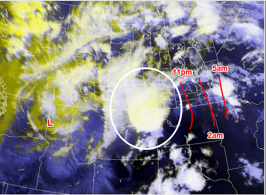
Sadly Tornado potential exists in model runs at 1am for Winnipeg on Friday.

As you can see there appears to be a very high risk for severe weather tomorrow. Let's have a look at the data I came up with.
Moisture - No shortage of moisture. High dewpoints in the mid to high teens, possibly above 20C on Thursday. Humidex values above 35C.
Instability- Extreme Instability is in place for Thursday. CAPES on the order of 3,000 to 4,500 J/kg, Lifted Indicies between -7 to -12. Bulk Richardson Number in Dauphin at 13.26, Brandon (both at 7pm) Winnipeg at 13 (1am). Anything in the teens is optimal for supercells. Total Totals is 68 in Dauphin, 58 in Brandon, 58 in Winnipeg which means scattered severe storms. SWEAT (Severe weather threat index) is 490 in Brandon,  847 in Dauphin, 595 in Winnipeg overnight altogether means supercell potential.
Shear- Significant shear is possible on Friday in between 200 to 500 m2 s-2, as well as EHIs of 3 to 8 in the southwest portion of the province. Significant Tornado is at 4 to 6.
T-Trigger Cold Front coming through later in the day time late afternoon out West and late evening to overnight in the Red River Valley East MB.

Severe Thunderstorms and supercells are most likely to fire late afternoon to early evening in Western Manitoba.


Put this altogether we have a explosive environment for severe thunderstorms tomorrow afternoon and evening. To start off once the cold front interacts with the heat and humidity ahead of it expect discrete supercell thunderstorms to fire off late afternoon in the Western half of the province as far North as Swan River they will pose a tornado threat with the highest risk areas being the Dauphin area East towards Lake Manitoba into southwest Manitoba. Supercell potential is very high tomorrow afternoon into the evening and overnight. Alongside with winds in excess of 100km/h, golf ball to base ball size hail, heavy rains with as much as 75mm expected to fall, and dangerous frequent lightning as it moves east southeastwards. Storm Chasers will be out tomorrow afternoon and evening in the West.

Overnight Severe Storms expected in the eastern half of the province.

Possible Evolution of a dangerous bow Echo Overnight into Friday

Winnipeg could be hit by this bow echo on Thursday Night.
High Shear expected Thursday night with decent supercell potential

Supercell potential in the Red River Valley on Thursday Night, nothing as big as the Western half of Manitoba though.
Once that all evolves expect that there will be some kind of straight line wind event with possible embedded tornadoes, the risk of violent tornadoes is present in the Red River Valley and Winnipeg  overnight on Thursday but if anything expect winds in excess of 100km/h, hail up to golfball or baseball size, rains as high as 75mm to 100mm, frequent lightning and of course the usual shelf clouds the system will move east southeast late afternoon to overnight as it moves into either Northwest Ontario or Northern Minnesota. Please make ure you tie everything down that you can in the case of this potentially being a big wind event. Temperatures will stick around twenty degrees overnight on Thursday. Please listen for watches and warnings put out by Environment Canada tomorrow and take shelter when severe weather hits. Never film a tornado when it is coming at you, head to shelter immediately!  You can use these tools to prepare and see what the weather will be like....
https://spotwx.com/, http://scottkehler.powweb.com/june0816/, http://weather.gc.ca/, weather.cod.edu/forecast/ http://www.pivotalweather.com/model.php?m=nam4km&p=refcmp&rh=2016060812&fh=42&r=conus&dpdt=
 and my page.... www.michaelmcgregor7.wix.com/southmbwxcentral


Here is a run down of the areas requested earlier tonight:

West Central: Dauphin,Binscarth, Roblin, Ste Rose, Ethelbert, Amaranth, Sidney, Basswood, Newdale.: High Risk of Severe. Supercells Likely mid afternoon and early evening, Tornadic potential is there with strong tornadoes possible late afternoon and evening. Clearing Mid Evening.

Southwest: La Rivirie, Boissevain, Melita, Glenboro, Brandon, Baldur, Pilot Mound, Treherne, Oak Lake, Hartney, Virden, Cartwright, Miami, Spruce Woods, Somerset, Shilo, Waskada, Neepawa.: High Risk of Severe. Supercell thunderstorms are likely late afternoon to mid evening, Tornadoes are a threat and could be very strong when they develop. Clearing by mid to late evening.


RRV: Erickson, Elm Creek, Culross, Grosse Isle, Ste Agathe, Haskett, Carman, Sanford, Kane, Winnipeg (Saint James, Silver Heights, Transcona, St.Boniface, Downtown, River Heights, Charleswood, East Kildonan, West Kildonan, Wolseslely). East Saint Paul, West Saint Paul, Elie, Portage La Prairie, Emerson, Lowe Farm, Winkler, Morden.: High Risk of Severe. Straight line wind event likely mid to late evening with embedded tornadoes possible albeit weak, winds in excess of 100km/h, hail up to golfball or baseball size, rains as high as 75mm to 100mm, frequent lightning and of course the usual shelf clouds.

SE: Vita, Grunthal, Piney, Sprague, New Bothwell, Steinbach. Moderate Risk of severe. Thunderstorms may very well mis you depending on how far southeast they dig. If you get hit you will be in the main event: winds in excess of 100km/h, hail up to toonies and hen eggs, rains as high as 50mm, frequent lightning and of course the usual shelf clouds.

East MB: Beausejour, Marchand, Seddons Corner, Anola, Whiteshell. Moderate Risk of severe.  Main action may miss you and slide past the border south of you or you will get hit by the main line with winds in excess of 100km/h, hail up to toonies and hen eggs, rains as high as 50mm, frequent lightning and of course the usual shelf clouds.

Interlakes: Fraserwood, Arborg, Gimli, Stony Mountain, Fisher Branch, Selkirk: High Risk of Severe. Supercells and Straight line wind event likely mid to late evening with embedded tornadoes possible albeit weak, winds in excess of 100km/h, hail up to golfball or baseball size, rains as high as 75mm to 100mm, frequent lightning and of course the usual shelf clouds.

More chances of showers and storms run through the end of the week on Friday with a possible severe weather day again as well. The weekend has more severe chances possible, it is just too soon to get into details. Temperatures in the mid to high 20's possible under humid conditions.

Featured Post

Major Rainfall first of the season for Southern Manitoba.

Hello folks of southern Manitoba this is another weather update, we have some interesting weather on the way a low pressure system developin...