Monday, July 26, 2021

Slightly warmer week ahead, thunderstorm chances

 Much of southern Manitoba has been stuck in a period of dry weather as a result of high pressure, that unfortunately has contributed to drought conditions. The trend of dry weather looks to change somewhat as a somewhat active storm track sets up. 


The heat continues!!! Here’s a look at Tuesday’s temperatures. Yikes, low to mid 30’s possible as a trough of low pressure draws in heat and humidity from the south. 

The rest of Monday: Southern sections of Manitoba have had some showers and thunderstorms as part of an area of low pressure sitting over central Manitoba , some lake breeze boundaries have been sinking south from the Manitoba lakes and this has resulted in some thunderstorms at times forming. Hail was also reported in the St vital area of Winnipeg. For the rest of the day today sunny skies are expected, some cloud cover is likely in areas of southeastern Manitoba with some showers possible. Temperatures are forecasted to rise into the mid to high 20’s (23 to 29C)for much of southern Manitoba with areas along the border seeing highs in the low 30’s. (30-32C). are still expected to reach there daytime high by 6pm-7pm. Winnipeg: Partly cloudy: 30% chance of showers with the risk of thunderstorms. High 29C. Brandon: Sunny high 30C. Dauphin: Sunny, high 24C. 

Monday Night: I’m expecting clear to partly cloudy skies with a light breeze out of the NW, overnight low temperatures will likely drop into the mid to high teens (14 to 18C) Tuesday night. Winnipeg: Clear, low 15C. Brandon: Clear, low 15C. Dauphin: Clear low 14C. 

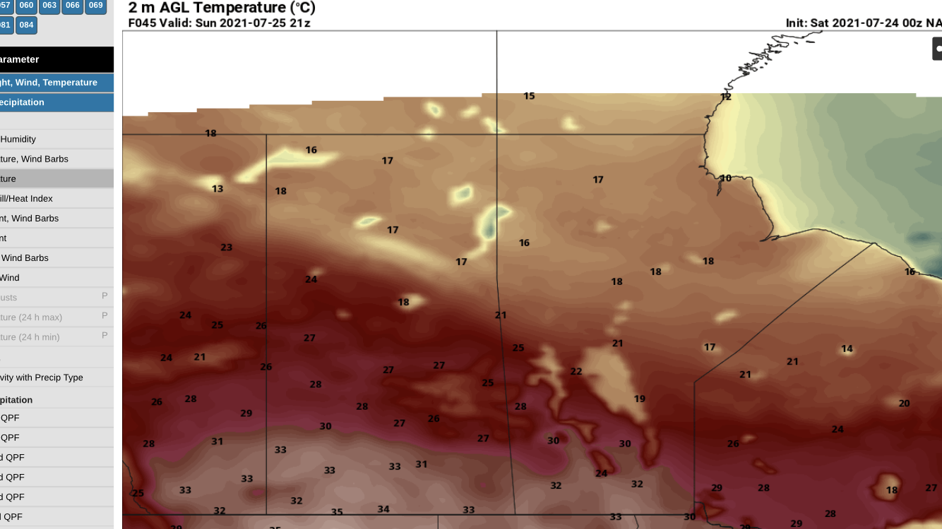
Tuesday: Will be one of the warmest days ahead, sunny skies are expected. However towards the latter half of the day a trough will move into southern sections of Manitoba and create a risk for severe weather. A large area of CAPE from 1,000 to 2,000J/Kg looks possible in areas of the parklands into central Manitoba. The only issue is that capping may prevent storms from forming in the late afternoon and evening. If they do form they will have the capability to be severe. With large hail , damaging winds and intense lightning with the risk of a tornado. The storms will probably form in the parklands and central before moving east south east with the rest of southern Manitoba at risk of thunderstorms in the evening and overnight. There will be a slight risk of severe as they move southeast as hinted by the RDPS and NAM models however I expect mainly remain non severe though. There is a chance they could entirely miss the southern half of Manitoba so prepare for possible dissapointment, Temperatures will soar into the low to mid 30’s (30 to 35C) with high twenties expected in southeastern Manitoba (25 to 30C). Winnipeg: Sunny, then partly cloudy with 60% chance of showers and thunderstorms risk of severe thunderstorms in the late afternoon. High 33C. Brandon: Sunny, then partly cloudy. 30% chance of showers with risk of thunderstorms. High 35C. Dauphin: Partly cloudy with 60% chance of showers and thunderstorms, risk of severe thunderstorms. High 33C. 


Tuesday Night: I’m expecting a chance for the showers and thunderstorms to head south and east into Ontario by mid to late evening leaving clear skies.   Heading into the overnight I’m expecting clearing skies for the overnight period, overnight lows will drop into the high teens and low 20’s (18 to 23C) with an area of low pressure sitting over the area. Winnipeg: 60% Chance of showers/ thunderstorms in the evening with risk of severe then clearing. Low 23C. Brandon: Clear, low 20C. Dauphin: 60% chance of showers and thunderstorms with risk of severe in the evening then clearing low 19C. 

Wednesday: Should be one of the calmer days weather wise, mostly cloudy skies are expected for the first half of the day before sunny skies take over for the rest of the day. High pressure off in BC will give a bit off a westerly flow in the province. Temperatures are expected to soar into the low to mid 30s in areas of southern Manitoba except for the parklands interlakes and eastern Manitoba where high 20’s are likely. Winnipeg: Partly cloudy then Sunny. High 31C. Brandon: Partly cloudy, then sunny high 32C. Dauphin: Sunny high 30C. 

Second half of the week: The hot weather continues and I expect that temperatures will soar into the low to mid 30’s once again on Thursday with our overnight lows in the high teens and low 20’s. There will be a risk for thunderstorms again at the end of the week as a cold front moves through on Friday. 

Friday, July 23, 2021

Seasonal weekend Ahead


Much of southern Manitoba continues to see well below average precipitation, as the majority of low pressure systems that have moved through have brought with them little to no precipitation with most of it falling in northern sections of Manitoba. The weekend ahead will be marked with calm conditions thanks to a zonal flow and slight ridging aloft,  partly to sunny skies are expected with little to no precipitation. Temperatures this weekend look like they will be sitting in the high 20’s to the low to mid 30’s, with overnight lows in the mid to high teens. There are signs that this pattern will change early next week with a active storm track possible over the southern prairie provinces.  I will have a blog update on Monday about that possible outcome. 

Monday, July 19, 2021

Smoky conditions and slightly unsettled weather ahead.


 Much of southern sections of Manitoba is seeing reduced air quality as a result of a a cold front passing through this morning, a northeast to northerly wind is taking over ushering in smoke from the wildfires in northern Manitoba and Ontario. (as seen in this air quality map above).

Monday Night: A cold front will be draped across the northern plains with another area of low pressure sitting over Saskatchewan. Increasing cloud is likely across all of the southern half of Manitoba, as a low pressure system moves into the area from Saskatchewan. Thunderstorms are likely to develop in areas of southwestern Manitoba this evening and drift into areas of southcentral or extreme southern Manitoba late this evening and after midnight with a risk of some severe storms. Most of the thunderstorms will travel east-southeast and will likely clip the border as they move into North Dakota . There is however a risk of some severe storms staying on the Manitoba side. Elsewhere smoke looks to be a major factor in the overnight period as a northeasterly wind comes in play behind these thunderstorms. The southeastern half of Manitoba however will be expecting clear to partly cloudy conditions, with heavy smoke in those areas. Temperatures for the region tonight will vary, low temperatures will drop into the mid teens in the interlakes, parklands (12 to 15C). Temperatures in the high teens in southern sections of Manitoba (15-18C). Winnipeg: Partly cloudy, 60% chance of showers or thunderstorms (some storms may be severe) smoke increasing overnight. Low 17C. Brandon: Cloudy with 60% percent chance of showers and risk of severe thunderstorms. Low 18C. Dauphin: Partly cloudy with 30% chance of showers and risk of a thunderstorm low 15C. 

Tuesday: During the morning hours showers with  thunderstorms some severe will be likely in the regions of the red river valley, that should clear come the afternoon hours. More showers are expected for a large section of the southern half of Manitoba expecting showers starting in the morning in the southwest moving into eastern sections come the afternoon. Smoky conditions will also be sitting over the region as a result of the wildfires in eastern Ontario. Temperatures will not rise much as they have over the past couple of weeks. High temperatures are expected to reach the mid to high 20’s (23 to 29C). Much of the heat is expected to sit over the northern plains. Winnipeg: Partly cloudy with 40% chance of showers, risk of thunderstorms in the morning. High 29C. Brandon: Partly cloudy, 40% chance of showers in the afternoon high 26C. Dauphin: Partly cloudy , 30% of chance of showers. High 27C. 

Tuesday Night: Another batch of showers and embedded thunderstorms are expected to come into areas of southwestern Manitoba during the evening hours , this appears however to be a large area of rain with embedded thunderstorms. This will likely move east through the evening and overnight, exiting the province by morning. No severe thunderstorms are expected however.  Temperatures are expected to drop into the mid to high teens, (15 to 19C). Winnipeg: Cloudy, 60% chance of showers and risk of thunderstorms. Low 21C. Brandon: Cloudy, showers beginning in the evening. Risk of thunderstorms. Low 18C. Dauphin: Cloudy, 60% chance of showers. Risk of thunderstorms. Low 18C. 

Wednesday: Partly cloudy skies with local smoke is likely during the day. Another slightly unsettled day will likely set itself up over the southern half of Manitoba, a low pressure system will be sitting over southwestern Manitoba, with showers and a risk of thunderstorms  developing over the region mainly in the red river valley and southeastern sections of Manitoba. However the chances look much slimmer than on Tuesday night. Temperatures are expected to rise into the mid to high 20s (24 to 29C) with the coolest temperatures expected in the parklands. Winnipeg: Partly cloudy with 40% chance of showers and risk of thunderstorms. Local smoke High 29C. Brandon: Partly cloudy, 30% chance of showers high 28C. Dauphin: Partly cloudy, high 24C. 

Wednesday Night: Clear to partly cloudy skies are expected with a bit of a southerly wind coming in for the region, temperatures are expected to be in the high teens to low 20’s overnight. Winnipeg: Clear, low 23C. Brandon: Clear, low 18C. Dauphin: Clear low 18C.

Second half of the week: It appears we will be in for increasing heat over the second half of the week with day time high temperatures soaring into the mid to  high 20s to mid 30’s for daytime highs and overnight lows in the high teens to low 20’s. The jet stream appears to setup over our area and will be ideal for multiple low pressure systems to ride through our area, with chances at showers and more thunderstorms.    Smoke may be a issue still. Welcome news for those that are suffering from drought.

Sunday, July 18, 2021

Hot and Stormy Weather continues

 Much of southern Manitoba has been experiencing off and on scattered thunderstorms this weekend, some of which have been severe. There was a few thunderstorms that created some hail damage in southwestern Manitoba last night. More unsettled weather is on the way.  Let’s have a look and see what exactly will unfold as a cold front moves through. 


A cold front currently draped across central Manitoba will dig south into a hot and humid airmass, sunny skies and clear conditions have been in place for much of the day. Temperatures have soared into the high 20’s to low 30C range with dew points currently sitting in the high teens and low 20C range. Ahead of the front CAPE values of 2,000 to 3,500 J/Kg with Lifted index values from -5 to -8( meaning thunderstorms are likely some severe) are building in southern sections of Manitoba. Looking at shear values in order for storms to maintain themselves EHI values have been consistent in the 0 to 4 range with shear within 25 to 35 knots. Once this cold front moves into the hot and humid airmass thunderstorms should fire and grow upscale into a line of thunderstorms with the potential for large hail and damaging winds in excess of 100km/h, 2 to 4cm hail and rainfall in excess of 25 to 50mm. Thunderstorms will probably form in areas of the Duck mountain to Dauphin regions and points east into the inter lake regions from 5:30pm to 10pm. Then will probably converge and travel further south into the red river valley, southwestern and southeastern Manitoba from the 9pm to 3am timeframe. Some people may not get a thunderstorm depending on how long they maintain strength for and how large an area of the south they cover. 


Environment Canada Discussion: 


THUNDERSTORM FOCUS SHIFTS INTO SOUTHERN MANITOBA TODAY AS A COLD  
FRONT PUSHES SOUTHWARDS INTO A HIGH-ENERGY ENVIRONMENT. SOUTHERLY  
WINDS WILL CONTINUE TO ADVECT MOISTURE INTO THE REGION WITH A POOL OF  
DEW POINTS OF 20-22C GROWING ACROSS THE PROVINCE WHILE TEMPERATURES  
CLIMB INTO THE 30S OVER THE REGION. MLCAPE VALUES WILL CLIMB INTO THE  
2000-3000 J/KG RANGE WITH 0-6 KM BULK SHEAR VALUES OF 15-25 KNOTS.  
THE COLD FRONT, SITTING ALONG A LINE FROM SOUTH-CENTRAL SASKATCHEWAN  
TOWARDS DAUPHIN, MB (CYDN) THEN EASTWARDS ACROSS THE INTERLAKE THIS  
AFTERNOON, WILL SLUMP SOUTHWARDS LATER TODAY IN THE WAKE OF THE  
PASSAGE OF THE EASTERN SASKATCHEWAN LOW.  
 
THIS ENVIRONMENT WILL BE STRONGLY CAPPED FOR MUCH OF THE DAY, BUT THE  
DYNAMIC FORCING OF THE COLD FRONT WILL LIKELY BE ENOUGH TO TRIGGER  
THUNDERSTORMS ALONG THE FRONT BY LATE-AFTERNOON. THESE THUNDERSTORMS  
WILL PUSH SOUTHWARDS WITH THE FRONT THROUGH THE EVENING HOURS WITH  
PRIMARY THREATS OF DAMAGING HAIL AND WIND GUSTS. THE THUNDERSTORMS  
WILL LIKELY BE ISOLATED IN NATURE OVER SOUTHERN SASKATCHEWAN, BUT IN  
MANITOBA THERE IS ENOUGH DYNAMIC FORCING AND DIRECTIONAL SHEAR TO  
SUPPORT UPSCALE GROWTH INTO A BROKEN LINE THAT PUSHES SOUTHWARDS  
THROUGH THE NIGHT.  


Here’s your forecast for tonight.

Winnipeg: Partly cloudy, then increasing clouds with 60% chance of showers or thunderstorms (some may be  severe). Low 23C. Brandon: Partly cloudy with 60% chance of showers and thunderstorms, some may be severe. Clearing before morning. low 17C. Dauphin: Partly cloudy with 60% chance of showers or thunderstorms some may be severe, clearing before morning. Low 14C.

Justin and I will update you on the thunderstorm threat as it develops over the coming hours. -Mike McGregor

A blog will be done tomorrow talking about the week ahead . 


Wednesday, July 14, 2021

Hot and Dry weather Persists

 Much of southern Manitoba is expected to continue to see drought and calm conditions, along with typical summer instability (possible thunderstorms) a ridge of high pressure will keep our weather calm for the next while. 


Thursday: Much of the day in southern Manitoba will be quite sunny, a high pressure system will sit over eastern sections of the province before it moves into Ontario by evening. There will be enough instability for some pop up showers and thunderstorms in areas of southwestern , south central, southeastern sections of Manitoba. Temperatures are expected to rise into the high 20s to low 30s (27C to 34C). Winnipeg: Partly cloudy, 30% chance of showers and risk of a thunderstorm high 32C. Brandon: Partly cloudy, 30% chance of showers and risk of a thunderstorm. High 31C. Dauphin: Sunny, high 33C. 

Thursday Night: Calm weather conditions are expected, clear skies are also expected, temperatures are expected to drop into the mid to high teens and near 20C for some people (16 to 21C). Winnipeg: Clear, low 20C. Brandon: Clear low 20C. Dauphin: Clear low 21C. 

Friday: This will be one of the hottest days of the week ahead, a southerly flow with the area of high pressure off to the east will boost our temperatures into the MID TO HIGH 30C range. (30 to 38C). Sunny skies are expected during the day. Stay inside if you can and stay cool!!. Winnipeg: Sunny, high 37C. Brandon: Sunny, high 36C. Dauphin: Sunny high 36C. 

Friday Night: A cold front will be sitting over the region in central Manitoba, there is some good news as temperatures will drop enough to cool things off overnight to make it manageable for those without air conditioning. Temperatures will drop into the mid to high teens and low 20’s (16 to 22C). There is a possibility for thunderstorms in the dauphin and swan river regions shortly after sunset. However they will be non severe and will bring meager rainfall. Winnipeg: Clear, low 20C. Brandon: Clear low 19C. Dauphin: Partly cloudy 30% chance of showers and risk of a thunderstorm. Low 20C. 

The Weekend: Unfortunately a persistent westerly to southwesterly flow aloft will contribute to the dry and hot conditions continuing, it’s possible we will see highs in the mid to high 30’s and low to mid 20’s. Low pressure systems will continue to move through northern Manitoba with most of the rainfall missing, southern sections. There may be a change to wetter weather in the next week. Stay tuned !

Monday, July 12, 2021

Heat and Unsettled weather Ahead

 Much of southern Manitoba has experienced a hot and dry weekend, temperatures soared into the low to mid 30s. Fortunately this trend looks like it may have some hope in store, an area of low pressure will move through the region and it may bring a chance for unsettled weather. There might be a threat for severe weather as well. Read on to find out more . 


Monday: Much of southern sections of the province will be basking in the heat, it appears a band of showers and weak thundershowers will move through the southern half of the province early in the morning. Sunny to partly cloudy skies are expected. A cold front and attendant low pressure system will approach the region, by mid to late afternoon. CAPE values are expected to be in the 1,500 to 2,500 J/kg range with bulk shear values only of 20 to 30 knots. Once that front goes through the heat and humidity, there is a chance of severe thunderstorm development come the afternoon period. Model data I have looked over appears to hint at isolated to scattered thunderstorm development particularly after a line of thunderstorms moves through the region currently to 3pm. with a risk of thunderstorms becoming severe in between the hours of 12pm-9pm. The best risk for severe weather will be up into the inter lakes from Portage La Prairie east to the Ontario border south to the USA border. The potential would be mainly gusts to 100km/h, 2 to 4cm hail and heavy rainfall.  Temperatures will soar into the low to mid 30s (30 to 35C). Humidex values more so in the high 30s (35 to 40C). Winnipeg: Sunny, increasing clouds by morning. Then 70 percent chance of showers and risk of thunderstorms (some severe). High 28C. Humidex 35C. Brandon: Partly cloudy , 30 percent chance of showers in the morning and early afternoon. Risk of a thunderstorm early in the afternoon, high 29C. Dauphin: Mainly cloudy with 30 percent chance of showers. Risk of a thunderstorm late in the afternoon. High 27. Humidex 32. Monday Night: It appears that the cold front will move through the region come the late evening, behind it moderating temperatures are expected. Overnight lows are expected to drop into the mid to high teens. Clear skies to partly cloudy skies are also expected. Winnipeg: Partly cloudy. 40% chance of showers in the evening. Risk of a thunderstorm early in the evening.  Low 18C. Brandon: Partly cloudy low 15C. Dauphin: Partly cloudy. Low 17C. 

Tuesday: A cold front is expected to drop south with a northwesterly flow aloft , the unfortunate part of this is that the front will also bring behind it smoke from fires burning in northern Saskatchewan. Sunny to partly cloudy skies are expected there will also be a risk for thunderstorms in the afternoon and evening. Temperatures will soar into the low to high twenties (22C to 27C), with the cooler temperatures in the parklands regions. Winnipeg: Partly cloudy, then 60% chance of showers in the afternoon with risk of thunderstorms. hazy with smoke high 27C. Brandon:  Partly cloudy, then 60% chance of showers in the afternoon with risk of thunderstorms, hazy with smoke high 26C. Dauphin:  Partly cloudy, then 60% chance of showers in the afternoon with risk of thunderstorms  hazy with smoke high 22C. Tuesday Night: Clearing skies are expected, as the front moves south into North Dakota. There may be a few left over showers however that should clear by evening. Temperatures will drop into the low to mid teens, overnight (13 to 16C). Winnipeg: 30% chance of showers in the evening with the risk of a thunderstorm. Low 16C. Brandon: Partly cloudy, 30% chance of showers with a risk of a thunderstorm in the evening. Low 16C. Dauphin: Partly cloudy, 30% chance of showers in the evening. Risk of a thunderstorm. Low 16C. 

Wednesday: Sunny and hot weather is expected to return for the day, high pressure should arrive back in the region. The only thing is that smoke will filter into the region again as a northwesterly flow sits over the area and hazy skies will likely give way to less sunlight coming in. High temperatures will soar into the mid to high 20s once again. Winnipeg: Sunny, hazy with smoke. High 29C. Brandon: Partly cloudy. Hazy with smoke high 26C. Dauphin: Sunny, high 28C. Hazy with smoke. 

Wednesday, July 7, 2021

Summer Weather Makes A Comeback

 Much of southern Manitoba has been seeing a cooler than average weather pattern over the past few days , a northwest flow at first which transitioned into a northeast flow that allowed forest fire smoke into the province. Finally, some good news is that our weather is about to get much warmer into the next couple of days, a southerly flow will take over for the second half of the week. Read on to find out how warm it will get and what we can expect for our weather ahead below.


Wednesday Night: Southern Manitoba will be on the eastern edge of an area of high pressure that will begin filtering a southerly flow into the province. Partly cloudy skies are expected, for the overnight period with some thicker cloud cover across areas of extreme southern Manitoba. Overnight low temperatures will drop into the low to mid teens, 11 to 16C. Winnipeg: Clear then increasing cloud after midnight low 15C. Brandon: Clear, increasing cloud after midnight low 11C. Dauphin: A few clouds overnight low 15C. 

Thursday: An area of low pressure will skirt the border from southeastern Saskatchewan into North Dakota, it will miss our area however. So I expect sunny skies across much of the southern half of the province. There will be a slight risk of thunderstorms across the southern half of Manitoba from the southwest into the Red River Valley regions, mainly west of and including Winnipeg. This is evident on the ECCC thunderstorm outlook risk map. Slightly increasing heat is expected across the Canadian prairies, thanks to a southerly to westerly wind in place will contribute to temperatures within the mid to high twenty celcius range (25 to 29C). Also the smoke will be out of the province and mainly focused in areas near the Ontario border, so the air quality should see improvement. Winnipeg: Sunny, high 28C. Brandon: Sunny, high 28C. Dauphin: Sunny high 27C. Thursday Night: An area of high pressure will move into the northern regions overnight into Friday. Mostly clear conditions are expected into the night. No notable weather is expected. Overnight low temperatures will remain in the mid to high teens, with values from (14 to 18C). Winnipeg: clear, low 16C. Brandon: Clear, low 18C. Dauphin: Clear low 15C. 

Friday: The day on Friday will be fairly calm weatherwise, under high pressure a westerly flow will sit over the region. Sunny skies are expected for the day on Friday, some areas of the province will see more cloudcover off and on under partly cloudy skies. Temperatures will soar into the high 20’s and low 30s, with the hottest weather occurring in the interlakes and areas of western Manitoba. Winnipeg: Sunny, high 30C. Brandon: Sunny high 30C. Dauphin: A mix of sun and cloud high 30C. 

Friday Night: Calm weather conditions are expected overnight with very little in the way of cloudcover or precipitation. Temperatures will drop into the mid to high teens (15 to 19C) with some locations staying around 20C overnight. Perfect night to keep the windows open. Winnipeg: Clear low 19C. Brandon: Clear, low 19C. Dauphin: Clear low 20C. 

The Weekend: It appears there will be an increasing amount of gulf moisture arriving in the region which may aid in the development of unsettled weather meaning showers and thunderstorms into the weekend and the beginning of the week. Temperatures appear, to sit in the twenties to low 30s for the weekend. 

Featured Post

Major Rainfall first of the season for Southern Manitoba.

Hello folks of southern Manitoba this is another weather update, we have some interesting weather on the way a low pressure system developin...