Monday, March 28, 2022

Low Pressure system to impact southern Manitoba, cool weather continues.

 Another developing low pressure system is expected to impact southern sections of Manitoba as well as North Dakota over the next 24 to 48 hours, unfortunately a lot of the precipitation will fall as snow, as river levels in the Winnipeg area are getting close to flood level, but remain below at the moment and properties are currently at risk for flooding along Winnipeg rivers. https://winnipeg.ctvnews.ca/winnipeg-warns-some-properties-may-be-at-risk-of-river-flooding-1.5837981 Regardless read on to find out about the timing, impacts and precipitation amounts as well as how our temperatures will be affected by this system. 

Tonight: The low pressure system is forecast to start moving into  our area overnight into Tuesday with an initial batch of freezing rain and mixed precipitation moving through western Manitoba and the parklands regions during the early morning hours. Tonight temperatures will drop to the low to mid minus single digits (-1C to -6C) under cloudy skies. 

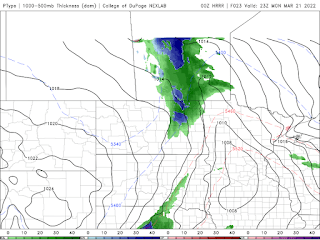
Tuesday: The area of precipitation that moves into the parklands during the morning will move into the interlakes regions by the morning with a intensification of the system by the early to mid afternoon with a transition over to snowfall during the afternoon hours. A brief period of showers is forecast over the red river valley shortly after lunch. Then Snow will fill in from the North to the south throughout the afternoon with a general 5-10cm of snow expected , most of it will melt on contact as temperatures remain mild during Tuesday. There is the exception of areas along the border along highway 75 where showers and a risk for freezing rain or ice pellets will exist shortly after 2pm-5pm before a full transition over to snow by the early evening hours. Temperatures during Tuesday afternoon will rise into the low single digits to around zero degrees celcius (0 to 2C), with areas north of the trans Canada highway seeing high temperatures in the low minus single digits (-1C to -4C). 

Tuesday Night: I’m still expecting the snow to fall in the south central and south eastern portion of Manitoba but it will weaken towards the midnight hours in the south central with some areas in the south east seeing snow and flurries overnight into Wednesday. When all is said and done a general 2-4 extra cm of snow is possible. Winds will begin to increase out of the northwest as this system moves off into Ontario, by overnight into the morning hours winds will be 50 to 60km/h gusting to 70km/h possibly. Overnight low temperatures will drop into the low to mid minus single digits (-2C to -6C). 

Wednesday: The low pressure system will move off into the Lake Superior region leaving residual flurries in the morning and early afternoon hours, as a northerly flow pulls in. Cloudy skies will be in place during the day with sunny skies as well as clearing coming in by the late afternoon and early evening Temperatures surprisingly will not cool off much, with a large area seeing highs in the low to mid minus single digits (-1C to -5C) that’s good news!!

Wednesday Night: Clearer skies are forecast as a weak high pressure system slides through ,, some cloud is possible in the overnight in the southwest. Temperatures won’t drop much at all, with much of the area seeing lows in the low to mid minus single digits (-2 to -8C), with the warmer values occurring in the southeast. 

Second half of the week: Calm weather continues, a clipper system might swing through on Thursday or Friday with minimal precipitation expected. Temperatures will remain mild with day time highs in the low minus single digits on Thursday and lows in the high minus single digits , and Friday where high temperatures will be in the low single digits and low minus single digits for overnight lows. Signs are that this pattern of warmth continues into the weekend, we will keep you updated on any new information by Friday. 


-Mike McGregor 

Thursday, March 24, 2022

Low pressure system to bring Snow and to end the Week

 Much of southern Manitoba has been experiencing a mild and sunny week, as forecast with temperatures in the low to mid single digits, that trend looks to continue. However a high pressure system will work it’s way into the province on Friday afternoon, with calmer weather and cooler weather for the weekend, but not before a batch of snow moves in tonight. Read on to Find out what we can expect for precipitation tonight and where the most impacts will be felt as well as what we can expect for our temperature trend. Blog will include details through the weekend. 


Tonight: Another batch of moisture associated with the low pressure system will move through our area. (Above). As it moves eastwards, a batch of snow will form with a band of rain showers ahead of the snowfall. Snowfall amounts will be limited with only 2cm max expected. Blowing snow can be expected but because of the melt, drifting snow will be limited. There unfortunately will not be much in the way of accumulation as most of it might melt on contact. Tonight temperatures will drop into the low to mid minus single digits (-2 to -8C). 

Friday: Eastern parts of southern Manitoba will still be impacted by a low pressure system with snow still falling in the east until the early afternoon hours, with sunny skies in the western half of Manitoba but clearing will likely take over during the latter half of the day. Temperatures will rise into the mid to high minus single digits (-5C to -10C) with areas in the interlakes seeing highs in the low minus teens (-10 to -15C).

Friday Night: Calm conditions are expected with overnight low temperatures dropping into the low to mid minus teens (-10 to -15C), areas in the southwestern half of Manitoba and the extreme southwestern portions will see lows in the mid to high minus single digits (-6C to -10C). 

Saturday: Mostly cloudy skies to partly cloudy skies are expected on the day Saturday with temperatures warming up into the mid to high minus single digits (-4C to -9C), and over the Manitoba lakes temperatures will hover surprisingly over the low minus teens (-10 to -12C). 

Saturday Night: High pressure will continue to dominate the pattern, as it sinks south over Manitoba. Temperatures will drop well below normal with most locations seeing temperatures in the low to mid minus teens (-10 to -16C), with windchills in the high minus teens and some locales over the parklands and interlakes seeing minus twenty values. That just makes me cold thinking about it . 🥶🥶🥶

Sunday: Warmer weather arrives as our pesky high pressure system moves east into Ontario, as a result a southerly flow will flow over the region. Some periods of cloud and sun can be expected, temperatures will rise into the low to mid minus single digits (-2 to -7C). Much of the same can be expected Sunday night with cloudy skies and low temperatures dropping into the upper minus single digits (-6 to -9C). 

The week ahead: Calmer weather arrives, however there’s signs that this pattern could change by mid week with a potential significant snowfall by Wednesday. Models are differing on timing and amounts but a Colorado low will swing south of us with us on the northern end , we could get a snowstorm next week. We will keep you in the loop on this . 


This is also,, the system that will be the culprit of that weather … 


Slightly below normal temperatures continue, with daytime highs in the low to mid minus single digits for daytime highs, and overnight lows in the high minus single digits. 

-Mike McGregor

Sunday, March 20, 2022

Wet and unsettled pattern to start off Spring

 Much of southern Manitoba will be impacted by a Colorado low system that will bring a significant amount of precipitation over the next 24-48 hours. This forecast will be short as I do have time constraints but we will get to the details that are important. 


On Monday a clipper system (above: Top 4pm. Bottom: 8pm) will be streaming moisture northwards with a Colorado low, to the south. Ahead of this system a large area of rain and mixed precipitation will be moving into our area. Temperature for the southwest part of Manitoba will remain a few degrees or 2 above zero with some sections in the parkland regions staying around 0C likely bringing a chance for mainly snow and rain. The areas in the eastern half of Manitoba will be warm enough for rain mostly as temperatures sit in the low to mid single digits (2 to 5C). As the system moves into the region a batch of rain and snow will impact parts of western Manitoba before moving into the rest of the region, with temperatures warm enough in the eastern half of Manitoba for rainfall. In general a wide swath of 5-10mm of rain can be expected, with a transition over to snow by about 5-7pm in the red river valley. Total snowfall amounts of 5-10cm can be expected, with lesser amounts as you go west of Winnipeg. Please be careful and adjust to road and highway conditions as weather may deteriorate tomorrow , also be careful about ice developing on roads as temperatures drop after the rain and snow . 


This system will exit the province by the late evening into the morning hours.  Overnight low temperatures on  will drop into the low to mid minus single digits with some areas dropping into the upper minus single digits (0 to -8C). 

Tuesday and Wednesday: Both look to be beautiful days, with sunny skies and high pressure. Tuesday temperatures look to sit in the mid to high single digits (2 to 5C). Overnight lows in the region will also sit in the low to mid minus single digits (-2C to -8C), the coldest of the temperatures are expected in the interlakes regions. A little more cloudcover is expected in the afternoon hours our high temperatures will suffer as cloud sits over the red river valley and eastern Manitoba, with highs around zero or a degree or 2 above zero. Areas in western Manitoba will manage to warm up into the mid to high single digits (5 to 8C). Overnight lows on Wednesday Night will drop into the low to mid minus single digits (-2 to -5C). 

Monday, March 14, 2022

Spring Weather finally arrives, Let the Melting Begin ❄️🌊


I have seen signs of positive change in the weather pattern and finally there is hope on the horizon, our polar vortex (Above) which sat over much of the Canadian prairies has finally retreated into the North Pole and Greenland. Some of that cold air will be filtering backwards into Russia, what that means for us is warm pacific air will start moving into our area and we should start noticing the difference over the next few days. Find out how warm it will get, and find out if this trend will last. This outlook is for Tuesday and Wednesday as well as Thursday.


Tuesday: An approaching low pressure system will be moving into Saskatchewan on Tuesday, ahead of it an area of clouds will filter in during the day. No significant weather is expected, until the late afternoon hours when rain and freezing rain will move in from west to east. The risk of freezing rain appears to only be in the interlakes and parklands region. With this system there will be accumulations of 5-10mm of rain. One of the previous weather models I saw mentioned a chance at thundershowers the other day , however that isn’t much of a possibility anymore. As for temperatures highs around the freezing mark, to a few degrees above zero degrees are likely (-2C to +2C)The only areas that may not see highs above zero are in the parklands and the interlakes. 

Tuesday Night: The low pressure system I mentioned will likely exit the province by the mid to late evening, behind it patchy freezing drizzle or rain is possible. Cloudy skies will be in place and a westerly flow will establish itself, with temperatures remaining above zero overnight in the south the only exception being the interlakes and over the Manitoba lakes where lows will sit in the high minus single digits (-2C to -4C). 


Wednesday: Should be a beautiful day, despite cloudcover being out, our daytime high temperatures will soar into the low to mid plus single digits (0 to 4C), the warmth will envelop the interlake regions as well. 

Wednesday Night: A trough of low pressure will swing through behind the low pressure system that affected us on Tuesday, as it does so a brief narrow swath of flurries and snow will move through from Nw to SE. Only a brief 2-4cm is expected. Temperatures will drop into the low to mid minus single digits (-1 to -5C). Not much in the way of windchill will be a factor. 

Thursday: The Beautiful slightly warmer weather continues and our temperatures will rise again above zero for much of the southern half. The only exception being the interlakes where our highs will sit in the low to mid minus single digits (-1 to -3C). Thursday Night will offer low temperatures in the low to mid minus single digits under cloudy skies. (-1C to -4C). 

The weekend: Signs are that this warmer than average trend will continue into the weekend, Friday, Saturday and Sunday all show temperatures remaining in the low to mid plus single digits and overnight lows in the low to mid minus single digits (0 to -6C).. There’s a possibility some areas near the extreme SW corner of Manitoba will see highs above 5C. We’ll see if that continues to show on future models. 

Enjoy the melt and the beginning of spring. ❤️❤️. 

Bonus Treat:

Here’s a small snapshot of all the snow that’s left to melt in my yard. ❤️❤️❤️ 


Friday, March 11, 2022

Snow arrives with Slightly Below Seasonal Weather For the weekend


This update will be brief albeit there is a lot to talk about for our weather this weekend, one of them being another clipper system moving into the region which will bring another round of snowfall (above) which will likely create for another day of impactful weather. I was looking over the forecast discussions from Environment Canada and they mention that the snowfall tomorrow may have more snow water equivalent than earlier in the season. EASTERN PRAIRIES...CLEAR SKIES AND COLD TEMPERATURES WILL GIVE WAY TO  

APPROACHING LOW FROM NORTHERN ALBERTA THIS EVENING. THE LOW WILL  
TRACK SOUTHEASTWARDS OVERNIGHT, PUSHING A SWATH OF SNOW THROUGH THE  
NORTHERN GRAINBELT OF SASKATCHEWAN OVERNIGHT AND INTO CENTRAL AND  
SOUTHERN MANITOBA THROUGH SATURDAY. THE LOW WILL BE MOVING QUICKLY,  
LIMITING SNOWFALL AMOUNTS, BUT WITH HIGH SLRS AND MID-LEVEL  
INSTABILITY, POCKETS OF HIGHER SNOWFALL AMOUNTS ARE LIKELY. GENERAL 
 
ACCUMULATIONS OF 4 TO 8 CM ARE EXPECTED.”” 

What this means is that there will be a period of heavy snowfall from the late morning into the late afternoon period. Snow will likely accumulate to 4 to 8cm with as much as 10cm in some locations. Snow and blowing snow will also likely be a hazard as winds gust to 50 to 60 km/h. Snow will clear by the early evening hours, with gusts of 60km/h likely in the southwest in the evening on Saturday. Temperatures for the weekend will warm up into the mid to high minus single digits this Saturday and Sunday, with temperatures between (-4C and -9C) and our overnight lows between (-5C and -16C). Windchill values on overnights will likely sit in the mid minus teens to low minus 20’s (-15C to -22C), a few areas might see low windchills around -30C). 

There are some signs of warmer weather filtering in for the week Monday into Friday, with temperatures sitting in the low minus single digits and a few degrees above zero for the first time, in over a month. This might help melt the current snowpack, hopefully not too quickly as lows look to remain below zero. 

Well update you more on Monday. 

-Mike McGregor 

Monday, March 7, 2022

Below Seasonal Temperatures ahead, after early week snowfall

 Much of southern sections of Manitoba and our region will be impacted by yet another Alberta clipper, 🤦🏻‍♂️ however this one will only make significant weather in Northern Manitoba and portions of central Manitoba into the interlakes mainly. There will be southward extending impacts such as light snow and strong winds. This system unfortunately will mark a transition over to a weeks worth of cold weather, and maybe longer. Read on to find out if minus twenties or minus thirties are in store. 


Tuesday: During Tuesday morning into the afternoon we should see the waning impacts of a low pressure system as it moves out of the province into Ontario, northwesterly winds gusting to 50km/h should abate by the late morning and early afternoon to light. Snow and light snow will continue throughout the day into the early evening hours, with general amounts of 2-4cm. Temperatures during the day will rise to the mid to high minus single digits with some areas in the parklands seeing highs in the low minus teens (-4C to -12C). Windchills will however sit in the mid to high minus teens , with low minus twenties possible in the parklands regions in small sections (-16C to -21C). Tuesday Night: Cloudy skies and light snow may persist until shortly after midnight in some sections. Generally partly cloudy skies are expected overnight with clear skies in some places at times. Overnight lows will drop into the mid to upper minus teens (-15 to -18C) eastwards away from the west and interlake regions, parts in the southwest to just west of Winnipeg and all points north will see lows in the low minus twenties (-20 to -25C). Windchills accordingly will likely drop into the mid to high minus twenties for most and the low minus thirties in the southwest and western portions. (-25 to -32C). 

Wednesday: During the afternoon a large area of high pressure will drift south into the western Canadian prairies. Sunny to partly cloudy skies are likely this will unfortunately prevent our daytime high temperatures from rising to our normal day time averages, we will likely be seeing high temperatures rise into the mid to high minus teens, (-14C to -17C) with windchill values sitting in the low to mid minus twenties (-21C to -26C). 

Wednesday Night: Much of the region will unfortunately see a significant drop in temperatures with areas seeing lows in the mid to high minus twenties (-24C to -29C), and windchills in the low minus thirties with a high minus thirties values being reached at some point (-32C to -36C). The fact that clear skies are gonna be in play there’s a risk that temperatures could drop below minus 40C but I don’t see that being likely. 

Thursday: Another clipper system 🤦🏻‍♂️🤓🤓 will probably come into the province bringing another round of snowfall, it’s hard to tell right now if the system will bring a risk of blizzard conditions. At the moment a general 5cm can be expected with lesser amounts in other areas especially the western half of Manitoba. Temperatures during the day will rise into the low minus teens (-10 to -12C), with the windchills likely sitting in the mid to high minus teens (-15C to -19C). Everyone will be between those values. I just also looked at the isobarbs after the system passes through and it seems there  could be a risk of a blizzard late Thursday. 

Update coming on Thursday evening or Friday.

-Mike McGregor 


Featured Post

Major Rainfall first of the season for Southern Manitoba.

Hello folks of southern Manitoba this is another weather update, we have some interesting weather on the way a low pressure system developin...