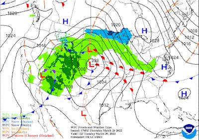
Much of southern Manitoba has been experiencing a mild and sunny week, as forecast with temperatures in the low to mid single digits, that trend looks to continue. However a high pressure system will work it’s way into the province on Friday afternoon, with calmer weather and cooler weather for the weekend, but not before a batch of snow moves in tonight. Read on to Find out what we can expect for precipitation tonight and where the most impacts will be felt as well as what we can expect for our temperature trend. Blog will include details through the weekend.
Tonight: Another batch of moisture associated with the low pressure system will move through our area. (Above). As it moves eastwards, a batch of snow will form with a band of rain showers ahead of the snowfall. Snowfall amounts will be limited with only 2cm max expected. Blowing snow can be expected but because of the melt, drifting snow will be limited. There unfortunately will not be much in the way of accumulation as most of it might melt on contact. Tonight temperatures will drop into the low to mid minus single digits (-2 to -8C).
Friday: Eastern parts of southern Manitoba will still be impacted by a low pressure system with snow still falling in the east until the early afternoon hours, with sunny skies in the western half of Manitoba but clearing will likely take over during the latter half of the day. Temperatures will rise into the mid to high minus single digits (-5C to -10C) with areas in the interlakes seeing highs in the low minus teens (-10 to -15C).
Friday Night: Calm conditions are expected with overnight low temperatures dropping into the low to mid minus teens (-10 to -15C), areas in the southwestern half of Manitoba and the extreme southwestern portions will see lows in the mid to high minus single digits (-6C to -10C).
Saturday: Mostly cloudy skies to partly cloudy skies are expected on the day Saturday with temperatures warming up into the mid to high minus single digits (-4C to -9C), and over the Manitoba lakes temperatures will hover surprisingly over the low minus teens (-10 to -12C).
Saturday Night: High pressure will continue to dominate the pattern, as it sinks south over Manitoba. Temperatures will drop well below normal with most locations seeing temperatures in the low to mid minus teens (-10 to -16C), with windchills in the high minus teens and some locales over the parklands and interlakes seeing minus twenty values. That just makes me cold thinking about it . 🥶🥶🥶
Sunday: Warmer weather arrives as our pesky high pressure system moves east into Ontario, as a result a southerly flow will flow over the region. Some periods of cloud and sun can be expected, temperatures will rise into the low to mid minus single digits (-2 to -7C). Much of the same can be expected Sunday night with cloudy skies and low temperatures dropping into the upper minus single digits (-6 to -9C).
The week ahead: Calmer weather arrives, however there’s signs that this pattern could change by mid week with a potential significant snowfall by Wednesday. Models are differing on timing and amounts but a Colorado low will swing south of us with us on the northern end , we could get a snowstorm next week. We will keep you in the loop on this .
This is also,, the system that will be the culprit of that weather …
Slightly below normal temperatures continue, with daytime highs in the low to mid minus single digits for daytime highs, and overnight lows in the high minus single digits.
-Mike McGregor


"There unfortunately will not be much in the way of accumulation"
ReplyDeleteWhat do you mean "unfortunately"? ��