Much of southern Manitoba will be impacted by a Colorado low system that will bring a significant amount of precipitation over the next 24-48 hours. This forecast will be short as I do have time constraints but we will get to the details that are important.
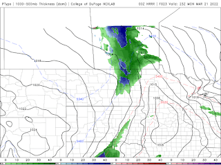

On Monday a clipper system (above: Top 4pm. Bottom: 8pm) will be streaming moisture northwards with a Colorado low, to the south. Ahead of this system a large area of rain and mixed precipitation will be moving into our area. Temperature for the southwest part of Manitoba will remain a few degrees or 2 above zero with some sections in the parkland regions staying around 0C likely bringing a chance for mainly snow and rain. The areas in the eastern half of Manitoba will be warm enough for rain mostly as temperatures sit in the low to mid single digits (2 to 5C). As the system moves into the region a batch of rain and snow will impact parts of western Manitoba before moving into the rest of the region, with temperatures warm enough in the eastern half of Manitoba for rainfall. In general a wide swath of 5-10mm of rain can be expected, with a transition over to snow by about 5-7pm in the red river valley. Total snowfall amounts of 5-10cm can be expected, with lesser amounts as you go west of Winnipeg. Please be careful and adjust to road and highway conditions as weather may deteriorate tomorrow , also be careful about ice developing on roads as temperatures drop after the rain and snow .
This system will exit the province by the late evening into the morning hours. Overnight low temperatures on will drop into the low to mid minus single digits with some areas dropping into the upper minus single digits (0 to -8C).
Tuesday and Wednesday: Both look to be beautiful days, with sunny skies and high pressure. Tuesday temperatures look to sit in the mid to high single digits (2 to 5C). Overnight lows in the region will also sit in the low to mid minus single digits (-2C to -8C), the coldest of the temperatures are expected in the interlakes regions. A little more cloudcover is expected in the afternoon hours our high temperatures will suffer as cloud sits over the red river valley and eastern Manitoba, with highs around zero or a degree or 2 above zero. Areas in western Manitoba will manage to warm up into the mid to high single digits (5 to 8C). Overnight lows on Wednesday Night will drop into the low to mid minus single digits (-2 to -5C).


No comments:
Post a Comment
Thank's for commenting on the blog, I appreciate it...