Wednesday, July 29, 2020

Warmth Gradually returns to Southern Manitoba

Southern Manitoba will have one more day before high temperatures rise and start feeling more summer like as a area of high pressure gradually moves east over the prairie provinces. Get ready for the warmer weather to arrive in the next few days! 


Thursday will be a hot day across Manitoba , high temperatures in the 30’s are possible for the SW portion of Manitoba. 


Southern Manitoba will have an exceptional day weather wise Wednesday, a area of high-pressure will be sitting over Manitoba bringing in calm winds and stable conditions. Partly cloudy skies are expected with high temperatures in the mid to high 20s across much of southern Manitoba areas around the lakes will be in around the low 20s. A high temperature of 26°C can be expected for the city of Brandon and a high temperature of 27°C can be expected for Winnipeg.

Overnight Wednesday into Thursday expects scattered to broken clouds with overnight low temperatures for much of the province dropping into the mid to high teens with areas in the Interlakes dropping to the low to  mid teens. A low temperature of 17°C can be expected for the city of Winnipeg a low temperature of 15°C can be expected for Brandon. 

Thursday the area of high-pressure should be moving east into Ontario so the winds will be out of the south to south south east. The heat starts kicking in on Thursday with High temperatures soaring into the high 20s to low 30s for the majority of the day. Humidex values will be in the 30 to 35°C range, some areas may surpass 37C humidex readings . A high temperature of 31°C is expected for Brandon and a high temperature of 30°C is expected for Winnipeg.  There will also be a risk for some thunderstorms isolated in nature mainly in southwestern Manitoba . 

Heading into the evening and overnight in south western portions of Manitoba an area of low pressure with a trailing cold front is expected to approach the Manitoba border. The risk for thunderstorms and severe weather would start in Saskatchewan with the risk extending east into Manitoba throughout the evening into the overnight hours .  Current model guidance is not showing much indication of organized convective activity,  we at Manitoba weather centre will update any changes to the outlook right now it looks like scattered thunderstorms are going to be possible for the night on Thursday into Friday. Overnight lows are expected in the mid to high teens for the majority of southern Manitoba a low temperature of 17°C can be expected for Brandon and a low temperature of 18°C can be expected for Winnipeg. 

The forecast for Friday gets a bit more complicated , The previously mentioned cold front across southern Manitoba during the overnight hours and will sit in south eastern portions of Manitoba by the morning hours on Friday. Current indications on the position of the front shows there may be a possibility of a severe weather set up with the risk of some severe thunderstorms particularly along and south of the TransCanada highway Into Southeastern Manitoba. If the front moves further north than expected the severe weather threat could extend into regions along and south of the lakes into the Interlake region. Well let you know what evolves on Friday . The front will gradually sag south throughout the day on Friday . So for Friday expect a mix of sun and cloud and a chance for showers or thunderstorms, severe thunderstorms are possible mainly in SE areas and border regions of Manitoba.  High temperatures will be in the mid to high 20s across the majority of southern Manitoba. High temperature of 25°C can be expected for Winnipeg and a high temperature of 28°C can be expected for Brandon. If the front manages to sneak a bit further north temperatures will be more so in the high 20s to low 30s but at this moment it looks like the majority of the heat will be on the other side of the US border. 

Overnight lows on Friday are expected to be in the low to mid teens with some areas in the southwest especially in rural regions Maci overnight lows just in around 10°C. The overnight low of 14C can be expected for Winnipeg and a low of 10°C can be expected for Brandon.

Heading into the weekend an area of high-pressure looks to slide south from northern Manitoba.  Comfortable and stable conditions are expected and high temperatures in the mid to high 20s. The next chance for unsettled conditions is possible by early to mid week next week. 

Saturday, July 25, 2020

Severe Weather Threat for Saturday , seasonable end to the weekend

Southern Manitoba is at risk for another round of severe weather this afternoon and this evening, with extreme heat and humidity in place as a cold front slides through the region . (Below: A photo of what it could look like around supper time for Southern regions including the Red River Valley. Note storms might be a bit more organized as they have developed earlier and further west than this model suggested )


The day ahead will be an active day as a cold front slides through southern Manitoba, high temperatures today are expected to be in the low to mid 30’s, with hunidex values surpassing the 40C mark up to 45C in some locations . As the day progresses there will be a large pool of CAPE of more than 2,000J/Kg and Bulk Shear around 30 to 40 knots , across a large section of the Red River Valley and eastern Manitoba, of concern though will be the CAP a CIN of around 20-50J/Kg could prevent storms from developing. Once the cold front goes through storms might be able to overcome the cap . If they do there’s a chance the storms will become severe enough for large hail up to Golfball or orange size , and wind gusts over 110Km/h. Storms will likely enter the Red River Valley after forming in the far western regions of the Red River Valley by the Manitoba lakes region . Storms will mostly be in a broken line , but if there’s enough time for them to tap into the shear there may be a better probability of forming into a solid line . 

Storms should exit the province by the evening hours. 

Lows tonight will be in the high teens , a low of 16C is expected for Brandon and 17C for Winnipeg . Clear conditions will also be present after the storms blow through . 

Sunday should be a calmer and quieter day weather wise with less humidity . High temperatures on Sunday will be in the low to mid 20’s and overnight lows in the mid teens are expected. A high of 26C is expected for Winnipeg and a High of 24C for Brandon. 

The beginning of the week looks like it’ll be pleasant and sunny . There will be building high pressure into the province as temperatures moderate and instead of reaching the 30’s , they will be more comfortable in the mid to high 20’s with little humidity only for the day Monday. However , the heat really cranks up on Tuesday into Wednesday. Storms are possible towards the middle and end of the week . 

Thursday, July 23, 2020

Heat wave coming to southern Manitoba

Southern regions of the province can expect a increasingly hot end of the week with temperatures heating up through the end of the week into the weekend and the humidity levels will also become more opressive. Get ready to turn up your Fans/ Air Conditioning.


The night ahead for Wednesday nights expect clear conditions and light winds out of the south as an area of high-pressure moves off into Ontario. Overnight lows are expected to drop into the mid to high teens with some areas staying around 20° overnight in extreme regions of southwestern Manitoba mainly.

The day ahead for Thursday will be an exceptionally hot one high temperatures will reach the high 20s for the most part in southern Manitoba there may be some regions in south western regions in Manitoba where temperatures exceed 30°C. Dew points will also soar throughout the afternoon with the majority of dewpoint temperatures getting into the high teens in the SE and  into the low 20s especially in southwestern Manitoba. High temperatures for the day on Thursday expect a high temperature of 28°C for Winnipeg and a high temperature of 31°C for Brandon.  As a result expect humidex values to reach the low to mid 40s in SW regions of Manitoba with values of 35 to 40°C in the red river valley and 30 to 35°C in the white shell.

On Thursday night a warm front will cross into southern Manitoba allowing for increasing amounts of humidity and moisture to flow in from the Gulf of Mexico. Along and ahead of the warm front there is a risk for severe thunderstorms in southeastern Saskatchewan and south western portions of Manitoba. Any thunderstorms that enter the province from Saskatchewan will have a threat for 2-4cm hail, gusts over 90km/h, and 50mm of rain . There will be a general threat for thunderstorms occurring throughout the night as the front moves east, current model trends show the activity moving NE into the inter lakes regions and Central Manitoba. With a risk for general thunderstorms elsewhere. Overnight lows will drop into the low to mid 20s overnight into Friday . A low of 22C can be expected for Winnipeg , and a low of 20C for the city of Brandon . 


Friday will be another hot day with a possibility of morning showers and thunderstorms , before clearing by afternoon .High temperatures for much of the region will be pushing the 30C mark, reaching the low to mid 30s. Humidex values will reach the low to mid 40’s. A high temperature of 34C is expected for Winnipeg and a humidex of 46C, and for Brandon a high temperature of 32C with a humidex of 45C. There may be a chance for a pop up shower or thunderstorm during the day given the heat and humidity in place , any storms that form will have the potential to be severe with the risk for all elements of severe weather including , Large hail and damaging winds , flooding rains also . This will be monitored as a warm front looks to drape itself over central portions of Manitoba during the day, possibly allowing for enough lift for storms to form. 

Friday night expect a risk for thunderstorms with a severe risk possible but the bulk of the energy will be in NW Ontario with the risk for severe storms possible there . Overnight lows won’t drop much with lows in the high teens to low 20s under the presence of a south to southwesterly flow. A low of 18C can be expected for Brandon and a low of 22C can be expected for Winnipeg . 

Heading into the weekend it will continue to be hot with High temperatures still in the mid to high 20’s to low 30’s. There will be a threat for severe weather on the day Saturday as a cold front slices through the heat and humidity , models are still not in agreement in regards to the severe weather setup on Saturday quite yet . Stay tuned ! More seasonal temperatures and calmer conditions are expected for Sunday heading into next week. More heat is possible mid next 
week . 
 

Monday, July 20, 2020

Seasonal week with some unsettled weather mixed in .

Southern Manitoba can expect seasonal temperatures and unsettled conditions for the week ahead with some rain possible as area of low pressure moves through the province. 


A look at possible rainfall accumulation with this system , a possibility exists for another 4 to 5 inches of rain in areas already . Let’s hope and pray that this doesn’t happen. Other models are suggesting that there will only be less than a inch. I shared this to make others aware in case it does happen . 

The week ahead should start on a seasonal note as an area of low pressure sits to the south of Manitoba with a occluded front or trough sitting over south central and central portions of Manitoba with a area of low pressure sitting in Western Manitoba near the Sask Border.  Throughout the day there should be increasing clouds going from partly cloudy to mostly cloudy for much of the day, there should be some periods where the sun pops out . West of this front there will be increasingly unsettled conditions with showers developing in western and particularly south western regions of Manitoba . There will be a chance for embedded thunderstorms in any showers which form. This risk will extend to the Pembina valley (Morris and points south ) from the southwestern regions of Manitoba . Areas in the southwest portion of Manitoba Can expect 1.5 to 2 inches of rainfall. High temperatures will not budge much with most areas only getting into the low to mid 20s. Areas in the southwest portion of Manitoba where rain and thunderstorms occur temperatures will only get into the 15 to 20°C mark. A high of 19°C can be expected for the city of Brandon and A high of 23°C can be expected for the city of Winnipeg. 

On Monday night expect showers to gradually move east south east crossing the international border just south of Winnipeg a small area of showers will likely sneak into the river valley in the evening and overnight hours but it should not give much accumulations. It should remain mostly cloudy for much of the night in southwestern Manitoba and the red river valley . Areas for much of southern Manitoba overnight will drop between 10 and 15°C except for areas in the white shell which may see a 15 to 20°C overnight lows. Expect a low of 14°C for the city of Winnipeg and a low of 13°C for the city of Brandon.


The day on Tuesday should be a similar story although there will not be much rainfall occurring in southern portions of Manitoba. The day should start off under partly cloudy skies with clearing expected towards the late morning to early afternoon. High temperatures will be in the 20 to 25°C range for much of southern Manitoba with a few spots near NW Ontario barely reaching 20°C. High temperature of 24°C can be expected for Winnipeg and a high temperature of 23C can be expected for the city of Brandon.

The night for Tuesday night should be fairly calm and quiet under partly cloudy to clear skies and mild conditions with overnight lows in the mid teens. A low temperature of 14°C can be expected for the city of Brandon and a low temperature of 15°C can be expected for the city of Winnipeg.  


The day on Wednesday will be a much warmer day as a upper Ridge starts building over the prairie provinces, The building ridge will allow for more stable conditions with winds shifting to the south, areas in the south west portion of the province can expect high temperatures in the mid to high 20’s with some areas surpassing 30C. A high of 27C is expected for Brandon and a high of 28C for Winnipeg . 


As we get towards the end of the week temperatures will start heating up as a upper Ridge starts building into the prairie provinces there will also be increasing chances for storms and for severe weather events as the heat cranking up with humidity likely coming out of the Gulf of Mexico.

 I can honestly say considering we’re in mid July we should be getting daily temperatures in the 25 to 35°C range so I expect more of these temperatures be an occurrence over the coming weeks and months just be glad we don’t have to think about what’s coming around the corner . 😆😆 I would take mosquitoes any day over the other stuff yeah you know what I’m talking about. 😄😂😂ðŸĪŠ

Have a good week - Michael McGregor


Wednesday, July 15, 2020

Seasonal temperatures to end the week; Severe Weather Possible to end the week

Southern Manitoba can expect a relatively calm and warm temperature pattern to end the week, there will also be a increasing threat for severe weather as we head into the weekend . 


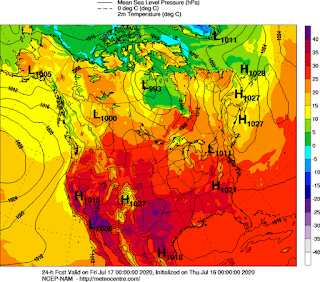
Beautiful warm weather expected across North America , southern Manitoba will be under the presence of warm and stable conditions before things change on Friday. The Low by BC in “L” will be in Manitoba on Friday. (Above) Enjoy the warm dry weather! 


The night ahead tonight looks like it will generally be a calm one as a area of low pressure moves north into Hudson’s bay . A trough hanging south of the system will sit over Southern regions of the province  remaining near stationary. Will bring a threat for showers and non severe thunderstorms in isolated sections , otherwise clear skies can be expected overnight into Thursday . Overnight lows tonight will drop into the 10 to 15C mark for the southwest region of Manitoba and the interlakes. Areas in the southeast will be warmer ahead of the trough with lows reaching into the 15 to 20C range . A low of  15C can be expected for Winnipeg and a low of 10C for Brandon. 

The day on Thursday will be much calmer in comparison to the past couple of days as Pop-up showers and thunderstorms made an occurrence over southern Manitoba. A trough is forecast to be in Southeast Manitoba by the morning hours, gradually moving into northwestern Ontario throughout the day time. There will be a risk for thunderstorms in the mid to late afternoon in extreme eastern portions of Manitoba along the trough. An area of high-pressure situated south of the border will be building into southwestern Manitoba for the majority of the day allowing for stable conditions to build in gradually from west to east behind the trough . That should result in a fairly pleasant day with high temperatures in southern Manitoba reaching The mid to high 20s. High temperature of 27 Celsius can be expected for the city of Brandon, and a high of 28 Celsius can be expected for the city of Winnipeg.

For the night on Thursday expect the area of high-pressure that is in North Dakota to gradually move east. Allowing for Calm and stable conditions ,temperatures for the majority will Drop between 10 and 15 Celsius some areas may only stick around the 10° Mark. For a low temperature Brandon can expect 13°C, and for the city of Winnipeg expect a low temperature of 15°C
 
The day on Friday will be notably more humid and hotter day temperature wise as an area of low pressure that crosses in from Saskatchewan , enters Manitoba with a abundance of gulf moisture ahead of it. This system will also pose a risk for severe weather as a cold front will be slicing through this hot humid air mass through the late afternoon and evening hours. High temperatures on the day Friday can be expected to be in the 25 to 30° range some areas may surpass 30° the humidity will feel more like the mid to high 30s or low 40s.  The National Weather Service has highlighted a slight risk of severe weather for southern Manitoba on Friday in the Dakotas as well. With MLCAPE values exceeding 2,000 J/KG In some regions .A general threat for Friday will be severe thunderstorms with the risk for supercell development depending on the setup and ingredients . Where in Manitoba these will form is yet to be determined by future model trends . A high of 30°C can be expected for Winnipeg Feeling more like 39 or 40°C, and a high of 27 Celsius feeling like 35 to 39°C for Brandon. 

 The outlook for the rest of the weekend into next week looks to calm down as a cold front slides south,  and a area of high pressure builds in with more seasonal temperatures expected in the mid to high 20s some areas may see temperatures in the low 20s especially in forested regions of southern Manitoba . More unsettled conditions may arrive sometime next week .


Monday, July 13, 2020

Seasonal temperatures and Unsettled conditions bring in the week.


Southern Manitoba has had seasonal temperatures and some dry weather for the past couple of days. This looks to change as an area of low pressure will continue moving through southern Manitoba to start the week. 

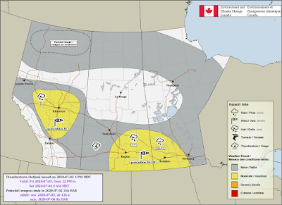
Southern Manitoba will experience a threat for severe weather once again on the day Monday. As detailed by this risk map from Environment Canada. 


To start the week southern Manitoba looks to start on a more unsettled note. A broad trough will be moving through southern Manitoba as well impacting parts of Minnesota and North Dakota, this will be the weather maker for much of the day Monday.  They day will start with a chance for showers and weak thunderstorms as residual convective activity from Sunday overnight in Western Manitoba weakens. Once showers clear, partly to mostly cloudy conditions should remain for the early afternoon before more showers and thunderstorms form in the Dakotas and possibly in Manitoba. These thunderstorms will likely develop from a area of showers and intensify in the afternoon impacting a large area of Western Manitoba into Eastern Manitoba . As CAPE will be anywhere from 1,000 to 2,000 Joules per kilogram there will be a threat for hail from 2-5cm , wind gusts up to 100km/h in eastern sections and 50-75mm of rain or more. Thunderstorms which are notoriously hard to predict where they will strike so I have detailed a chance across much of the south particularly the southeast is where we will have to keep our eyes on tomorrow . There will be a risk for Dauphin, Brandon and Winnipeg . High temperatures for the day on Monday will be in the 20 to 25C range for much of the region . Some areas in the white southwest may reach the 25 to 30C range with more sunshine expected there throughout the day . A high  temperature of 24° is expected for Brandon, and a high temperature of 26 Celsius is expected for the city of Winnipeg.

Expect showers and thunderstorms to clear the province by mid to late evening leaving a chance for showers overnight with cloudy skies and low temperatures in the 10 to 15° range overnight with a low of 11° in Brandon, And a low of 15 Celsius in Winnipeg.


Tuesday: On Tuesday an area of low pressure will be in northern Manitoba,  with a trough drooping south wards into southern Manitoba. CAPE ahead of the trough will rise into the 800 to 1000 Jper kilogram range some early indications are that there will be a risk for some thunderstorms on the afternoon on Tuesday this is the yet to be verified by future models.  In general expect mainly sunny skies with a chance of a pop-up shower or thunderstorm highs will be slightly near seasonal on Tuesday Only reaching between 20 and 25 Celsius. For Winnipeg a high of 23C can be expected and a high of 24C for Brandon . 

There will be a chance for leftover residual showers on Tuesday night with some periods of cloud and clear skies winds. will also be lights out of the west a low of 15 Celsius can be expected for Winnipeg,  and a low of 12 Celsius can be expected for Brandon. 


Wednesday: Calm and pleasant conditions are expected for Wednesday as a westerly flow takes place allowing for warm and stable conditions. High temperatures on the day Wednesday will be between 20 and 26 Celsius some areas in Interlakes maybe a bit cooler with the winds blowing off the lakes. Expect a high temperature of 26 Celsius in Brandon and a high temperature of 26° in Winnipeg.


The rest of the week...
Looks fairly stable with temperatures warming into the high 20’s or low 30’s.  As we head towards the weekend a couple of areas of low pressure will move into the region. Expect a chance for showers and thunderstorms increasing through the end of the week into the weekend. 

Tuesday, July 7, 2020

Seasonal temperatures with Unsettled Conditions

Southern regions of the province have finally shifted to a seasonal temperature pattern with a westerly to southwesterly flow after a long period of heat and humidity , which stuck around for days . That seasonal pattern looks to continue with a chance for some unsettled weather to sneak in . Read on to find out more

 .. 

A Look at what southern Manitoba could possibly experience on Tuesday Night heading into Wednesday . Some severe weather possible . 


The day on Tuesday will be a fairly pleasant day with sunny skies and high temperatures reaching into the mid to high 20s for much of southern Manitoba , the heat will be in southern portions of Manitoba where highs may reach close to 30C. Of note will be the southerly winds as a area of high pressure is just skirting off into The Ontario regions . If you live in SW MB , you might notice the humidity increase gradually through the evening with dew points increasing ahead of a disturbance that will be coming into Manitoba from Montana and North Dakota. Winnipeg can expect a high of 27C and Brandon can expect a high of 25C. 

Tuesday night will be a potentially active one across southern Manitoba , storms look to form in Saskatchewan and drift into Southwestern Manitoba in the late evening to overnight hours . There is a chance that some may drift into the Red River Valley shortly after midnight depending on the speed the storms travel . CAPE values overnight into Wednesday will be anywhere from 800J/Kg to 1,000J/Kg. As a front moves through, “ "Areas across Southwestern Manitoba will be in the higher risk for severe weather while areas East of Carberry will be at a lower risk due to some weakening likely".“ "The line of storms should reach SW Manitoba by 1:30 to 2am and then quickly move east but weaken some while doing so". as mentioned by Justin . There may also be a risk for small hail or up to Toonie size hail . Overnight Lows on Tuesday night will be for the majority in the low to mid teens with some areas in the high teens in the white shell regions . Expect a low of 15C in Brandon and 17C in Winnipeg . 

Wednesday should be one of those more unsettled days with some mixture of sun and clouds , a cold front will be positioned slightly just to the east of Winnipeg and the red river valley . A narrow ribbon of MLCAPE up to 1,500Jkg may be enough to allow for convection to fire up either just slightly west or east of Winnipeg depending on the fronts position by the mid to late afternoon . The most likely risk area will be in southeastern Manitoba where peak heating will allow for thunderstorms to form along the front as it moves into Ontario . Hail , and Strong winds are a threat as the storms possibly move into Ontario in the afternoon . High temperatures will be in the mid to high 20s on Wednesday with a high of 28C in Winnipeg and 25C in Brandon . 


Any thunderstorms within the province should clear on Wednesday night with calm conditions and partly cloudy skies, overnight lows can be expected in the low to high teens. A overnight low of 16C can be expected for Brandon and Winnipeg . 


Heading into the second half of the week looks to bring calm and sunny weather ,  with a chance for showers or weak thunderstorms on the day Thursday . High temperatures will be in the low to mid 20s for much of the region , with eastern regions in the high 20s possibly . 

Heading into Friday and Saturday expect much of the same with some summer like temperatures in the twenties and some possibly more unsettled weather to head into the weekend . 


Friday, July 3, 2020

No End In Sight to Heat and Thunderstorms

Southern Manitoba has entered a exceptionally Hot and humid spell that has lasted for days,  and it doesn’t look like it’s going to end anytime soon. The upper ridge will continue to sit over southern Manitoba as a stagnant upper pattern sits over the eastern Canadian prairies. 


The day on Friday will be a hot one,  The southerly flow will be coming out of the United States allowing for temperatures to boost once again in the 20 to 25° range some regions within southern Manitoba may surpass 30 Celsius. Dewpoint temperatures in southern Manitoba between 10 and 20 Celsius with areas along the American border reaching 15 to 20 Celsius dew points. It’ll make it feel closer to 35 to 40° for a Vast majority of southern Manitoba. For high temperatures expect a high temp of 33 Celsius in Winnipeg with A humidex of 41 Celsius. In Brandon expect a high of 31C and a humidex of 39C. Also southern Manitoba  Particularly southwestern Manitoba will have a risk of severe thunderstorms in the afternoon and evening hours,  the setup is conducive to heavy rainfall up to 75 mm along the Saskatchewan Manitoba border as well there will be a risk for gusts possibly over 100 km an hour. There is also a risk for severe hail with these thunderstorms that develop of note is the already saturated ground in southwestern Manitoba which does not need any more rainfall , which may receive more additional rainfall in In any thunderstorms that develop. Areas further east in central Manitoba and south central Manitoba there is a risk for non-severe thunderstorms in the afternoon and evening hours. 


Expect thunderstorms to weaken overnight and into the early morning hours, There is going to be a lot of humidity in the province of Manitoba overnight, with  lows quite mild and still in the heat warning criteria. There is a possibility for severe weather to stick around shortly after midnight to around 3 AM in the south western part of the province. Temperatures will be in the low to mid twenties overnight with a chance of thunderstorms throughout the southern part of Manitoba . A low of 20 can be expected in Winnipeg , and a low of 17C in Brandon. 

Saturday will be more complicated in terms of upper level setup. It looks like a low pressure system in North Dakota will lift north through the afternoon and evening triggering thunderstorm development likely moving north east throughout the afternoon and evening with further development in Manitoba in the late afternoon and  evening hours.  The SPC highlighted the red river valley at risk of excessive rainfall exceeding flash flooding level 10 to 20% which indicates there is a risk for severe weather in southern Manitoba on Saturday. Right now it’s hard to pinpoint where Exactly thunderstorms are going to occur on Saturday therefore I am going to update this blog on Saturday ,with a map from Environment Canada. At the moment it looks like the weekend will be unsettled with chances of showers and thunderstorms on Saturday in southern Manitoba. Expect a high temperature of 26 Celsius in Winnipeg and 25 Celsius in Brandon .

Saturday overnight Into Sunday expect showers and thunderstorms to continue in the night. Areas in the Red River Valley particularly may see most of the thunderstorms in that region . Expect overnight low of 17 Celsius in Brandon and 19 Celsius in Winnipeg. 

On Sunday a cold front looks like it will go through and bring with it unsettled conditions and possibly thunderstorms. A high temperature of 24C is expected in Brandon and a warmer high temperature of 26C in Winnipeg .

2PM Updates July 3rd: It looks like southern Manitoba will get a break from the humidity beginning of the week to the middle part of the week as dryer air filters into the province and high temperatures will still be in the mid to high 20s making it much more comfortable to be outside. Instead of having humidex values in the high 30s and low 40s they will be anywhere from 30 to 35C. 
 

A return to the heat is possible by the middle to later part of the week, will have to wait on later model guidance for that information.


Featured Post

Major Rainfall first of the season for Southern Manitoba.

Hello folks of southern Manitoba this is another weather update, we have some interesting weather on the way a low pressure system developin...