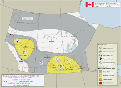
The day on Friday will be a hot one, The southerly flow will be coming out of the United States allowing for temperatures to boost once again in the 20 to 25° range some regions within southern Manitoba may surpass 30 Celsius. Dewpoint temperatures in southern Manitoba between 10 and 20 Celsius with areas along the American border reaching 15 to 20 Celsius dew points. It’ll make it feel closer to 35 to 40° for a Vast majority of southern Manitoba. For high temperatures expect a high temp of 33 Celsius in Winnipeg with A humidex of 41 Celsius. In Brandon expect a high of 31C and a humidex of 39C. Also southern Manitoba Particularly southwestern Manitoba will have a risk of severe thunderstorms in the afternoon and evening hours, the setup is conducive to heavy rainfall up to 75 mm along the Saskatchewan Manitoba border as well there will be a risk for gusts possibly over 100 km an hour. There is also a risk for severe hail with these thunderstorms that develop of note is the already saturated ground in southwestern Manitoba which does not need any more rainfall , which may receive more additional rainfall in In any thunderstorms that develop. Areas further east in central Manitoba and south central Manitoba there is a risk for non-severe thunderstorms in the afternoon and evening hours.
Expect thunderstorms to weaken overnight and into the early morning hours, There is going to be a lot of humidity in the province of Manitoba overnight, with lows quite mild and still in the heat warning criteria. There is a possibility for severe weather to stick around shortly after midnight to around 3 AM in the south western part of the province. Temperatures will be in the low to mid twenties overnight with a chance of thunderstorms throughout the southern part of Manitoba . A low of 20 can be expected in Winnipeg , and a low of 17C in Brandon.
Saturday will be more complicated in terms of upper level setup. It looks like a low pressure system in North Dakota will lift north through the afternoon and evening triggering thunderstorm development likely moving north east throughout the afternoon and evening with further development in Manitoba in the late afternoon and evening hours. The SPC highlighted the red river valley at risk of excessive rainfall exceeding flash flooding level 10 to 20% which indicates there is a risk for severe weather in southern Manitoba on Saturday. Right now it’s hard to pinpoint where Exactly thunderstorms are going to occur on Saturday therefore I am going to update this blog on Saturday ,with a map from Environment Canada. At the moment it looks like the weekend will be unsettled with chances of showers and thunderstorms on Saturday in southern Manitoba. Expect a high temperature of 26 Celsius in Winnipeg and 25 Celsius in Brandon .
Saturday overnight Into Sunday expect showers and thunderstorms to continue in the night. Areas in the Red River Valley particularly may see most of the thunderstorms in that region . Expect overnight low of 17 Celsius in Brandon and 19 Celsius in Winnipeg.
On Sunday a cold front looks like it will go through and bring with it unsettled conditions and possibly thunderstorms. A high temperature of 24C is expected in Brandon and a warmer high temperature of 26C in Winnipeg .
2PM Updates July 3rd: It looks like southern Manitoba will get a break from the humidity beginning of the week to the middle part of the week as dryer air filters into the province and high temperatures will still be in the mid to high 20s making it much more comfortable to be outside. Instead of having humidex values in the high 30s and low 40s they will be anywhere from 30 to 35C.
A return to the heat is possible by the middle to later part of the week, will have to wait on later model guidance for that information.


No comments:
Post a Comment
Thank's for commenting on the blog, I appreciate it...