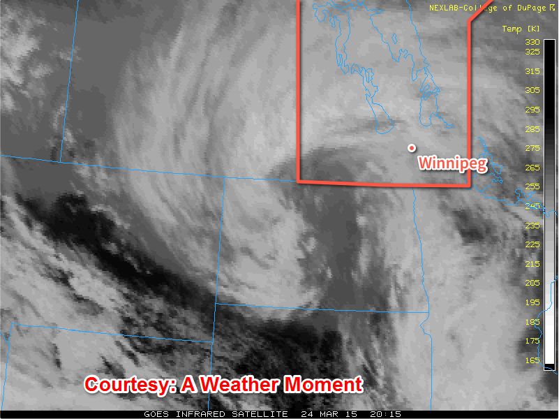
After a period of very warm weather that melted all of our snow last weekend in through the week , the snow came back with a vengence giving southern Manitoba another taste of Winter despite there being rainfa
ll with the system. During the day on Tuesday through Wednesday, the seasons first most potent storm system came through Southern areas giving regions impressive snowfall totals some areas racking up as much as 25cm. This appears to be the last significant snowfall of the season here in Manitoba, let's hope. (Totals shown below).

The snowfall and gusts of 60-70 km/h making visibilities low and highways very slippery, it was quite bad for motorists who were travelling along highway 75, 59 and Highway 1, 6, 16 and 10. 2 Accidents ocurred, one about 5km east of Elie with 2 semi trailers that collided in a jackknife collison. Also along highway 75 a schoolbus rollover occured by Ste Agathe. There were also several other rollovers that occurred which resulted in highway closures. http://winnipeg.ctvnews.ca/treacherous-road-conditions-lead-to-multiple-manitoba-crashes-1.2296304
There were also power outages in parts of Winnipeg, on Inkster and out in the Dugald areas. Southern Manitoba for the most part had numerous power outages caused by heavy snow and wind (which caused power poles to ignite). Manitoba Hydro is working on a fix for towns affected. On top of the snow that we recieved we also picked up about 8mm of rain here in the Winnipeg area. So what will our weather look like for the next few days? Let's have a look below.
The day on thursday will be a fairly cool day with the wind blowing from the Northwest fairly light, although given the strong March sun it may not feel all that bad outside. There probably will be a significant amount of melting given the below zero temperatures that are forecast for the day so it will probably feel nice outside. We cool down a couple degrees past the minus ten mark, overnight. May not all be that bad.
Mix of Sun and Cloud
-3C / -13C
Friday:

Friday will be a sunny day to start off in the red river valley, until a system slides through our region as flurries move out of southwestern Manitoba. Amounts of 1 to 2cm can be expected in the Winnipeg area. There will be a likely chance they will exit the region by around mid afternoon, any snow that falls will likely melt. High's will still be about 2 or 3 degrees below average in the Winnipeg area.
Flurries then Sunny
-2C/-12
Saturday Through Monday
Is it is looking like another storm system will be on our doorstep for the day on Saturday and Sunday. It is still quite far out to say anything yet, although given our model trends with past storm events it's quite likely this will turn out to be a event worth talking about.

However latest model runs are showing that it will be warm enough to support a rain event. That will likely be the case considering we are nearing the month of April, the rainy month. So it may be a cloudy and wet weekend with temperatures sitting above zero for the most part. It has been a dissapointment that our weather has not been dry and mild, however as we get further into Spring our weather will certainly get nicer. So with the look of things we are starting to enter a more typical stormy spring pattern, and hopes are that the weather will get a lot better and not stay gloomy and wet althrough the spring. We aren't in Vancouver after all. :-)


