Sunday, September 18, 2022

Heat and Humidity briefly return, late season severe weather threat arrives.

 Hello folks, this could be an interesting next few days ahead. Our region of the province will likely encounter another round of unusual warmth, humidity and summer like temperatures. Whats unusual is we have to look out for severe thunderstorms at the start of the week. Find out more about the severe weather potential and when this pattern will change and what to expect for the first half of the week. 

Monday: During the day a warm front will be expected to move into southern regions of Manitoba, this low pressure system will lift north into southern sections of Manitoba. Ahead of it a large area of CAPE 1,000 to 1,500 from southwestern Manitoba into the red river valley is likely to take shape. Temperatures during the afternoon will soar into the high teens to low 20’s in much of southern sections of Manitoba, the dew point will not to be too far off from the actual temperature so the humidex values will rise into the high 20’s to low 30’s which gives the average humidity levels close to 50 to 75%.


(Above): HRRR model suggesting the possibility of severe weather in the red river valley and interlakes areas of Manitoba after development in the southwest part of Manitoba. 

NAM model below suggesting similar conditions except later in the evening, and further north.


For the day Monday, model data appears to be in agreement now place in regards to placement and timing, as last night was still all over the place. The HRRR is in agreement with a lot of the higher resolution models and the NAM, which places thunderstorms developing and moving through the southwest part of Manitoba during the morning and early afternoon. By early to mid afternoon most of the instability will have built up. The red river valley, interlakes area in Manitoba should be on the lookout for showers and thunderstorm development during the afternoon, before a slight risk for severe storms moves in by late afternoon. 


(Dave Carlsens Tweet above talking about the severe weather threat possible later tod afternoon into the evening.)
There also will be a risk area in southwestern Manitoba with higher supercell composite values with the risk for tornadic development moving east as the evening goes on. Upscale growth into a thunderstorm complex by evening is possible that could travel east into the red river valley, supercells are still possible. Despite the sun setting earlier now storms will be fuelled by a large area of 1,500 to 3,000 J/Kg of CAPE with Energy Helicity values of 1 to 4 and shear in the range of 30 to 50 knots which will be Centred over the red river valley and southeast Manitoba as the cold front moves through in the evening. Large hail, damaging winds and an isolated tornado will be possible as they move east as a cold front Stay tuned to Manitoba weather center for updates, as well as my twitter page. 

Monday Night: Expect any thunderstorms to clear the area by evening, and late evening a northwesterly flow will take hold. Mostly cloudy skies are expected into the day on Tuesday. Overnight low temperatures will drop into the low to mid teens. 

Tuesday: Another calm sunny day is in store with a cold front moving through on the day Tuesday, a small chance of showers is expected in the southeast part of Manitoba. Temperatures on Tuesday will rise into the mid to high teens. 

Tuesday Night: A high pressure system will begin to dig southwards with a large area of cloud cover, moving southwards with it. Cloudy skies are expected by the morning hours on Wednesday. 

Wednesday: Much of the same weather can be expected with cloudy skies and high temperatures only rising into the mid to high teens. Areas in more rural regions will be in the higher single digits . 

Tuesday, September 13, 2022

Slightly cooler weather with Showers and Thunderstorms

 Southern sections of Manitoba will likely experience a period of unsettled weather over the next 24 to 48 hours, a low pressure system will be moving into southern Manitoba bringing with it another round of unsettled weather with showers and potential thunderstorms. Find out when and where in this weeks blog. 


Wednesday: This is when the pattern begins to change, a low pressure system will be off to our southwest in Montana, ahead of it a large area of cloud cover will filter into the region bringing with it a moist airmass. There will be partly cloudy to mostly cloudy skies as the system approaches, there also will be a large area of showers moving through the central parts of Manitoba in through the interlakes and western Manitoba including southwestern Manitoba. There’s a smaller chance for showers south of the Manitoba lakes. Amounts of 5-10mm is likely in the areas that receive rainfall. Temperatures on the day Wednesday will reach the mid to high teens with areas closer to the American border along and south of highway 1 seeing highs in the low 20’s. 


Wednesday night (Above simulated radar, lightning density, and rainfall amounts in inches for Wednesday Night): This is where the weather gets interesting, by early evening a large area of warm air will move north as a warm front sits just to the south of the border. This will allow thunderstorms to develop over southwestern Manitoba moving into the red river valley and eastern Manitoba. As these sit over the same area with the warm front staying just south of the border there’s the  likelihood of them training and moving over the same area for long periods of time, the reason being the flow will be west to east and the warm air advection will not move much further north than just south of the lakes. This may increase the risk for flash flooding potential. I will monitor this as more data comes in. Temperatures will drop into the high single digits to the low teens, on Wednesday night. 

Thursday and Friday: Calmer weather will arrive , there will be mostly cloudy skies expected on the day Thursday. There will also be cooler temperatures with highs on Thursday reaching the mid teens. Thursday night much of the same with low temperatures reaching the low teens and high single digits. Friday will only see highs in the low teens. 

Wednesday, September 7, 2022

Above Seasonal Temperatures Diminishing, slight chance of showers and thunderstorms to start the week.

 I apologize for not having any blog posts on the hot weather over the last few days. I took some time off for the long weekend, it was enjoyable as I was able to spend time with family and friends. Anyways Southern sections of Manitoba are likely to expect another day or 2 of hot weather, there’s also a chance for some showers and thunderstorms find out when and where in this blog weather update. 


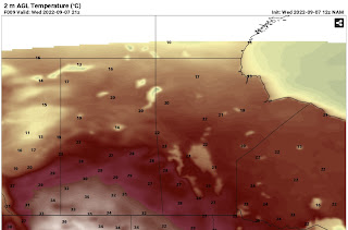
Temperatures above for the day on Wednesday showing the reality of the heat over western Canada. Some areas seeing highs in the low 30’s. 

Wednesday: Will end up being one of the nicest days of the week , high pressure will be off to our east in the northeastern USA which will contribute to a warmer than average airmass over our area. Temperatures during the day will soar into the mid to high 20’s with the hottest of the weather in southwestern Manitoba into the red river valley. 

Wednesday Night: A warm front and low pressure system will move through our area overnight the dynamics however are not as strong for severe weather than previously thought. There’s high amounts of instability with Thunderstorm energy in the 1,000 to 2,000 range but there will be sufficient capping (prevents storm formation as a layer of warm air overtakes areas where cold air is needed for storms) and limited amounts of moisture. If storms do form only isolated non severe thunderstorms are possible, with a very slight chance of a isolated severe storm. Best threat is in the red river valley late night early morning.  Temperatures will sit in the high teens to low 20’s on Wednesday night. 

Thursday: The low pressure system I mentioned will move out of the region bringing with it a chance for some showers or weak thunderstorms in the morning hours. Mainly cloudy skies are possible for the rest of the day with most of the moisture moving off to the east. Temperatures will probably reach the high teens to low 20’s for, the coldest of the air is expected to be in the west with warmer highs in the mid 20’s in extreme southeast Manitoba. 

Thursday night: Calmer weather is likely with a chance of clearing in some areas of the west. The cloud cover, fortunately will sit over the eastern half of Manitoba. With us being on the right side of high pressure it will give us a northerly flow aloft. Our temperatures will drop possibly into the mid single digits (3 to 5C) for the first time this fall especially in western Manitoba, sections of the red river valley and the interlakes. Winnipeg and southeastern Manitoba may see lows in the low teens. 

Friday: Will end up being sunny but a cooler than average day, our highs will only reach the mid to high teens. A persistent northerly flow will be part of the issue. Friday night temperatures will drop into the mid to high single digits across the south, these are more like October overnight lows. Frost is also a risk , once again I hate that darn Jack Frost. 😆😆. 

The Weekend: Warmer weather arrives , on Saturday temperatures in the high teens to low 20’s is possible overnight lows in the high single digits in the west and east and low teens in the red river valley. Most of the warmer weather coming on Sunday, I’m looking at a return to temperatures in the high 20’s on Sunday and into the week where high temperatures in the low 30’s are possible with lows in the mid teens to low 20’s.  Humidity may increase as well so we will have to watch for showers, thunderstorms. However it could end up being a dry heat with current data showing low dew points. That could change especially near the end of the week as a trough of low pressure builds in. That’s another reason why I don’t trust long range forecasts , data is inconsistent. 

Featured Post

Major Rainfall first of the season for Southern Manitoba.

Hello folks of southern Manitoba this is another weather update, we have some interesting weather on the way a low pressure system developin...