Saturday, May 28, 2022

Warm Weekend Ahead with Severe weather Possible LIVE BLOG

 Southern sections of Manitoba have had warmer than average temperatures over the past few days, unfortunately that trend looks to shift over to a wetter and more unsettled pattern over the next 24-48 hours. 


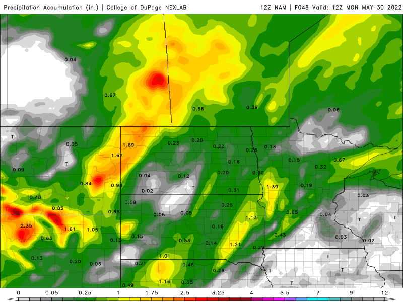
(Above): Total rainfall for the region with upwards of 20 to 40mm in the western half of Manitoba by Monday.

 The rest of today: A low pressure system will move into our area over the next 12 hours ahead of it extensive cloud cover will sit over our area, with periods of sun and heat in between. Most of the unsettled weather is not expected until tonight. Temperatures for today are still likely to rise into the low to mid 20’s in the areas along the American border, areas north of the trans Canada highway will likely see temperatures in the low 20’s and points north in the high teens. Unfortunately the parklands will only see highs in the mid teens due to continuous cloudcover.  

Tonight: As the low pressure system from the southwest approaches tonight, with another low pressure system draped over central Manitoba a large swath of rain will move in overnight into Sunday morning as weakening thunderstorms move in from North Dakota with the bulk of it falling in southwestern sections of Manitoba, before spreading into all of the region by morning. There’s a chance some of the precipitation could contain embedded thunderstorms which would result in higher amounts of precipitation that could fall. By morning a general 5-10mm will likely have fallen. Areas in western Manitoba could see upwards of 10 to 35mm by sunrise ( in southeastern Saskatchewan a rainfall warning has been issued there for significant rainfall as another low to the west affects them). Temperatures tonight should drop into the low teens in the southeast part of Manitoba towards the pembina valley (west of Morden) northeast into the Selkirk areas, areas from Winnipeg and points west can expect to see lows in the low teens tonight. Areas in the parklands can see lows in the high single digits. 


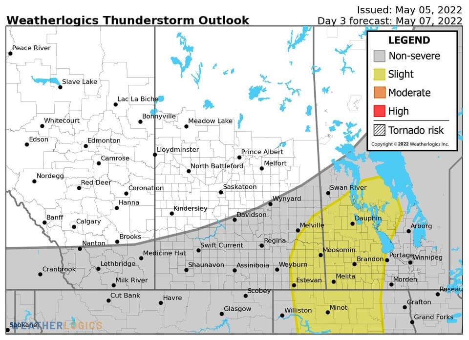
(Above): Severe Thunderstorm risk for Sunday in southern Manitoba. 


(Above): Skew T Graph for around Winnipeg, on Sunday evening. 

Tomorrow (Sunday): By morning there’s a chance that the south could be dealing with rainfall with embedded thunderstorms, it’s difficult to determine where the rain will be the heaviest because the HRRR is only showing it the heaviest over the southwest and some parts of the parklands. Where the NAM is mentioning the heavy rains across the region. I’m expecting showers and thunderstorms in the morning which is a major concern due to the flooding already happening in the red river valley and the parklands, interlakes. Rain and showers will continue on Sunday in the parklands and western Manitoba with upwards of 20 to 40mm of rainfall. Regardless, a general 15 to 30mm is likely in the extreme southwest, with areas further east mainly Brandon to Portage La Prairie seeing 10 to 15mm. Areas in the red river valley only seeing 5-10mm. Then by early afternoon those showers should clear and move into the northern interlakes and parklands. Then cloudy skies are likely across the southwest. The southeast including Winnipeg the red river valley and the southeast part of Manitoba will then likely have to deal with a warm front advancing northwards. It will not only bring in warmer temperatures and humidity, but our dew point temperatures will likely warm into the mid to high teens and the low 20’s in the red river valley with temperatures near or above 20C This will be enough to allow thunderstorm development, with MLCAPE and SBCAPE rising into the 1,000 to 3,000Joules per kilogram and the risk also exists for severe weather although a slight risk. What concerns me is that the low will be really close to the red river valley, the Energy Helicity Index which indicates tornado potential has been between 2 and 4 to 6 on the scale as well as helicity values between 200 to 600m2s2 meaning the risk for tornadoes are there. The result would be a risk for supercell thunderstorms to form by early to mid to late afternoon in the red river valley with initial risks of large hail, damaging winds, intense lightning, and a tornado or 2. Then there would be upscale growth into a line of thunderstorms. A note is that the warm front may not be able to move far enough north to present a risk for severe thunderstorms, and instead may just impact the northwestern Minnesota and eastern North Dakota. Regardless a severe weather threat will be present tomorrow in the southeast part of Manitoba. The southeast could see 20 to 30mm of rainfall in thunderstorms during the afternoon and evening again all dependent on where the thunderstorms form. Temperatures on the day Sunday will rise into the low teens in the parklands and the interlakes, areas in southern sections of Manitoba will see highs in the mid to high teens with the exception of the border areas seeing highs in the low 20’s. 

Sunday Night: Most of the activity should clear out by the evening to the early overnight. Calm weather should overtake the region with temperatures dropping into the low to mid teens with some areas in the interlakes dropping into the high single digits to low teens. 

The week: There will be a chance for more unsettled weather with a chance for showers and thunderstorms in the southeast part of Manitoba, on Monday evening into Tuesday with 20 to 30mm of rain possible. Calmer weather will arrive by the middle week. Temperatures will likely sit in the low to mid teens for daytime highs and high single digits for lows. 

Wednesday, May 25, 2022

Showers and Thunderstorms possible to end the Week

 Southern sections of Manitoba have been experiencing beautiful, calm seasonal weather thanks to a ridge of high pressure that has been building in to southern Manitoba. This trend looks to continue, with mild temperatures expected. The only caveat to this is that a trough might go through sections of Manitoba on Thursday bringing slightly unsettled weather. Find out what this means for Manitoba by reading more below.


 This blog will be shorter and brief as not a lot of active weather looks to occur until the weekend, as for the day today there will be some slight instability in southern sections of Manitoba ahead of a low pressure system. Pop up showers and thundershowers are possible during the afternoon today into the early evening, non severe weather is expected however. As for the rest of the week on Thursday another chance for showers and thunderstorms are possible, although isolated in nature.  Friday much of the same can be expected with minimal precipitation and sunny to partly cloudy skies, except into the evening hours on Friday a frontal system will move into the area bringing a brief chance for showers.With rain expected into Saturday morning.   Temperatures for tonight will drop into the high single digits in southern sections of Manitoba particularly the south central regions, areas in the interlakes and southwest/southeast Manitoba can expect lows in the low teens. During the day on Thursday much of the same for temperatures as it was Wednesday and it will help dry out the waterlogged fields. High temperatures are likely to sit in the low to mid 20’s in the southwest , with the eastern half of Manitoba in the high teens and low 20’s, colder as you go towards the white shell and sandilands. Temperatures on Thursday night will drop into the low teens (10 to 14C) the warmest overnight lows seen in at least 6-8 months. Friday temperatures are expected to rise into the low to high 20’s in all regions of southern parts of the province, areas along the American border have a good chance of surpassing 25C.  The further north you go the more likely you’ll see highs in the low 20’s or high teens especially in the parklands. Temperatures on Friday night will again drop into the low teens, with lows north of Gimli and dauphin (north parklands and interlakes) dropping below 10C. Same thing goes for areas along and around the Manitoba lakes. 

The weekend: Warm Mild weather continues, temperatures will be warm sitting in the mid to high 20’s with low 20’s also possible on Sunday. A frontal system will come through on Saturday evening and Sunday, humidity will be fairly high with dew points in the mid teens. Thunderstorms are possible both on Saturday and Sunday. Details to follow on Fridays blog, 

Wednesday, May 18, 2022

Wetter Weather Continues, showers and thundershowers possible to end the week

 Much of southern Manitoba is experiencing well above average precipitation this spring and this trend unfortunately looks to continue as another low pressure system is expected to impact southern Manitoba after the one we are experiencing moves out. Find out how this will impact our weather over the next 24-48 hours into the weekend. 


Wednesday: Earlier today Showers and Thunderstorms went through the parklands, interlakes, Red River Valley and the southeast parts of Manitoba this morning. The low pressure system that has been impacting us, has now moved into the northwest sections of Ontario. Behind it high pressure will build in briefly, cloudy skies are still expected however. Temperatures for the second half of the day today will rise into the low teens in the southeast (12 to 15C), areas in the southwest into the interlakes will only warm up to (4 to 9C.) 


Wednesday Night: Cloudy skies are expected overnight into the morning hours. An approaching area of low pressure will move into the region by early morning, bringing a chance of showers or rain to extreme western and southwestern sections of Manitoba by sunrise with only 5mm of rain expected by 6am. Temperatures will drop into the low to mid single digits for most overnight, with the coldest weather expected in the interlakes. 


Thursday (Above): By Thursday an area of low pressure will have moved into our region, I unfortunately have some bad news this system is going to drop a lot of rain in a short period of time for areas already struggling with flooding. Rain will begin to fall during the late morning to early afternoon across the western half of Manitoba, reaching the red river valley by the late afternoon with western portions being affected into the evening hours.   rain will persist until early evening in extreme southwest Manitoba, before a break occurs. There’s a chance of some weak embedded thunderstorms occurring during the afternoon and early evening hours in the swath of rainfall. By the early evening hours an entire swath of southern Manitoba and the interlakes will be seeing rain the exception being southwest Manitoba. By the evening a general 10-20mm of rain can be expected for southern sections with areas in the southwest and eastern Manitoba only seeing 5-10mm of rainfall. Areas in the parklands from Winnipeg north through lake Manitoba into Riding Mountains and Assessippi can expect a total from Wednesday morning to Thursday evening a general 30 to 70mm of rain to have fallen by evening, it’s probably adding the rain on top of the thunderstorms seen on Wednesday morning so a general 20 to 30mm can be expected on top of rain already fallen. Temperatures for the day will rise into the mid to high single digits in southwestern Manitoba, (6 to 10C), areas in south central and south eastern Manitoba will soar into the low to mid teens where highs might get as warm as 12C to 15C. 


Thursday Night: The position of the low will move over the American border into NW Ontario, with it the precipitation swath will orient itself west to east.  More rain will fall overnight for a large swath of the southern half of Manitoba, showers are likely closer to the American border. If colder air can wrap into this system overnight, which looks likely a section of southwest Manitoba and the parklands can expect a chance at light snow or flurries. By the morning some of those flurries could envelop parts of the red river valley but that looks a lot less likely than previous model runs. 

Rainfall accumulations Below:

RDPS 


 vs NAM model


Another 10 to 30mm of rainfall is likely by the morning hours on Friday through the parklands, interlakes, red river valley and eastern Manitoba. Lesser amounts of 5-10mm can be expected in the southwest and areas amongst the border regions. There is a chance that this could change however, depending on where the rain situates itself the higher amounts could end up further north with most of the red river valley, south central and southeast missing the rain. There’s a possibility that the heavier swath could also orient itself over and north of the American border with heavier amounts in SW MB, but most consensus is hinting at it being in a central locations of the south. Snowfall accumulations won’t total much , even though the NAM is saying 10-15cm for Dauphin and the western part of Manitoba. It’s an outlier. I would only assume that 5-10cm could fall and this is a long shot because normally we don’t see heavy snowfalls this time of year. Most of it would melt on contact before snow sticks. Based on the NAM model over projecting I’m gonna go with the RDPS solution, a general 1 to 5cm can be expected in any snow that falls in the parklands and in the southwest parts of Manitoba. THE GOOD NEWS IS I DONT SEE ANY SIGN OF A SNOWSTORM HAPPENING LIKE WE SAW IN MAY OF 2004. There’s a chance of seeing some flurries in southeastern Manitoba however the risk is lower. Temperatures on Thursday night will drop into the low to mid single digits, the coldest of the air in the southwest (3 to 7C) with areas in the parklands dropping below zero to around -1C areas in the southwest will be the coldest. 

Friday: Showers or flurries will persist in the morning hours before clearing by the late morning. Cloudy skies are likely as more of a northwesterly flow component moves in. Highs on Friday will be well below normal as temperatures are forecast only to rise into the mid to high single digits and around 10C. Our normals are around the high teens and low 20’s for this time of year. 

Friday Night: Clearer skies should take over with partly cloudy skies expected overnight, a northwest flow will continue to make it cooler than average. Most areas will drop into the low single digits or a degree or 2 or 3 below zero in patchy sections. 

The Weekend and Long Range: Temperatures look to finally rebound as the weekend arrives, there will be a good chance at sunshine returning with our daytime temperatures rising into the low teens and high single digits on Saturday. Saturday night overnight lows will drop a few degrees above 0C and below zero in the interlakes regions. Sunday and Sunday night will feature sunny skies and temperatures in the mid to high teens. Overnight lows in the mid to high single digits. The mild weather continues into next week. Chances at thunderstorms and or severe weather appear more likely as heat builds, GDPS is already hinting at more instability by next week. Will monitor for changes.  

Wednesday, May 11, 2022

Dry Week to End on Soggy Note, Showers and Thunderstorms to Arrive with Another Low

 Well folks as I write this, I know you might be saying “are you serious?!, or enough is enough!, or You’ve got to be kidding me”🤦🏻‍♂️🤦🏻‍♂️🤦🏻‍♂️. Well I’m starting to feel like saying it as well, another Colorado low pressure system still developing over the northern plains is expected to lift northwards over the next 24-48 hours. Another round of unsettled weather is expected as a result of this system. Read further to find out how this system will affect us. 


Thursday (Above: Low Pressure system and forecast rainfall totals with the 18Z RDPS). Southern Manitoba will definitely be impacted by a low pressure system, however model data is all over the place with some of the earlier models. However latest model data is now converging on a idea for the rainfall outlook. A strong Gulf of Mexico flow will result in significant amount of moisture for this system to work with. The day will start fairly sunny with partly to mostly cloudy skies, cloudier as you go into the southwest part of Manitoba. There will be a chance for showers or thunderstorms in the morning hours as a batch of thunderstorms pass over northern North Dakota with showers occurring further north. Western Manitoba will see rainfall occur off and on during the day on Thursday. The main event won’t start until late afternoon or early evening, consensus is showing a batch of showers and thunderstorms developing south of the border in northern North Dakota by late afternoon. A slight chance for showers and thunderstorms may occur in the early afternoon. A general 5 to 10mm of rain is likely by the late afternoon hours as most storms won’t impact the area until later on. Temperatures on the day Thursday will rise into the low to mid to high teens, (11 to 18C) with areas under showers and rain seeing lower day time highs. 

Thursday Night (Above): A large area of thunderstorms will likely develop over the Dakotas, that will impact a large area mostly stateside with Minnesota and Iowa getting the bulk of severe weather. As well there will be a large swath of showers or rain will move in from the eastern half of Saskatchewan that will envelop ALL AREAS of the south by the early evening, with the exception of the red river valley and southeast Manitoba.   There will be enough instability moving north to impact southern sections of Manitoba.


Thunderstorm Energy (Above): As for us we will see MUCAPE values or MLCAPES anywhere from 1,000 to 2,000J/Kg higher as you get closer to the USA border. Regardless another area of thunderstorms appear to develop either in northern North Dakota or southern Manitoba by the early evening, there will be a potential for significant rainfall in a very short period of time, also a threat for hail upwards of 1.0 to 1.5 inch in size. Most of these thunderstorms will hit southeastern Manitoba with the red river valley at risk as well, still yet have to determine where the heaviest of them will hit as models keep shifting overall track of these thunderstorms.The storm threat will persist into the evening hours with the track from south to north northeast, NW Ontario will likely see the storms move into the area as well. Most of the southwest and the parklands will see rain by the evening into the overnight period with embedded thunderstorms. A dry slot will fill in to the red river valley and southeast Manitoba after midnight.  


Rainfall accumulations in general are expected to be anywhere from 20 to 40mm, in southwestern Manitoba higher amounts in thunderstorms. (See the rainfall totals map above): Areas in southeastern Manitoba and the red river valley could see amounts between 30 and 50mm, amounts in localized locations could receive 60mm or more in thunderstorms. Much of the region will see temperatures drop into the high single digits in the southwest part of the province (5 to 10C), areas in the southeast will drop into the low teens (10 to 14C).  

Friday: Much of the south will likely dry, except the southwest and parklands where rain and showers will continue into the afternoon. The only exception winds will be strong on the eastern side of the low, gusts to 60km/h or more is possible in the south central, interlakes and southeast part of the province. Sunny skies are expected during the day in the southeast with temperatures for most of the region rising up into the mid to high teens, areas in the southwest will struggle to reach any warmer than 10C. 

Friday Night: The low pressure system I mentioned will move into far northern sections of Manitoba, calmer conditions are likely during the night. Temperatures will cool significantly cooler with lows averaging out around 4 to 8C. Some areas in the parklands could even drop towards 2 or 3C. 

The weekend: Calmer weather is forecast with high pressure forecast to take over on the weekend with temperatures in the mid to high teens forecast across the south with the exception of the interlakes regions seeing highs in the high single digits on Saturday. Overnight lows on Saturday night dropping well below average into the low single digits to mid single digits. Sunday will be a bit warmer with highs in the mid teens in the south with the warmth in the low teens getting as far north as the interlakes and bissett nopiming park regions. 

Monday, May 9, 2022

Chance of showers and thunderstorms for the week

Much of southern Manitoba has been soaked with rain and thunderstorms over the past week, this pattern looks to continue, unfortunately. Another area of low pressure is forecast to move into our region on the day


(Above): Green is light rain, yellow is heavy rainfall. During this afternoon a batch of showers and embedded thunderstorms will continue to impact southern Manitoba regions with a lot of rain with it, environment Canada has already issued a special weather statement for much of southern Manitoba in regards to this event. Consensus shows there will be a initial batch of precipitation today with some embedded  thunderstorms non severe mainly. 


Then as the low moves into the red river valley with a dry slot another round of possible convection could arrive by evening. 15 to 25mm likely this afternoon with another 5-10mm overnight. A general 20 to 40mm of rain is possible with higher amounts falling, in total. This is a huge concern as areas south of Winnipeg around highway 75 are dealing with serious flooding, the setup weather wise will just increase the flood waters and damage already caused (as noted above with the flash flooding risk map created by the national weather service in the states). 

Temperatures for today will warm into low to mid teens, in southeastern Manitoba while areas in the southwest will only get into the mid to high single digits or the low teens. The low should start moving out of Manitoba by the evening to overnight hours, with showers possible into the overnight period. Temperatures tonight will drop into the mid to high single digits, for most. 

Heading into the rest of the first half of the week calmer weather should move in as a high pressure system builds in, temperatures will rise into the mid to high teens on Tuesday and Wednesday with overnight lows on both days dropping into the low to mid single digits.

Second half of the week: More unsettled weather is possible with another few areas of low pressure forecast to move into our region, on Thursday and Friday. I will be watching closely as more rain and thunderstorms could create a risk of more flood potential. The risk of severe weather is still yet to be determined. Temperatures will continue to be a little more cooler than average with high temperatures in the low to mid teens with some days in the high teens towards the weekend, with overnight lows miss nights dropping into the seasonal averages of the mid to high single digits with some overnight lows especially in the southeast where lows could stay above 10C in the low teens. 


Friday, May 6, 2022

Seasonal weather continues, showers and thunderstorms for the weekend.

What a warm and beautiful week, we have had. You can thank a ridge of high pressure over the northern plains and low pressure systems building in the northwestern united states. However that is about to change as a low pressure system moves in for the 4th consecutive week in a row. This blog will briefly cover what to expect this weekend. 


(Above: Weatherlogics.com Thunderstorm outlook for Saturday from Facebook https://www.facebook.com/Weatherlogics/photos/a.283252022103980/1445751339187370/?type=3 ). Heading into tomorrow a low pressure system will approach southern Manitoba, and as it cuts into a warm airmass there will be a risk for thunderstorm development during the latter half of the afternoon. A general 1,000 to 2,000 J/Kg of CAPE is expected in the southwest part of Manitoba. Of concern will be the shear, the environment will be enough to support supercell thunderstorms in the afternoon and evening hours in southwestern Manitoba. The risk for a tornado is there. A line of thunderstorms will then grow upwards and move on east northeast throughout the evening, likely weakening by the time it hits the red river valley. 


The risks with these storms will be strong winds over 80km/h, large hail, damaging winds and a  tornado are possible (during initial stages of development, tornado or 2 is possible. After this line moves into the red river valley the storms will likely weaken as they enter a weaker environment for thunderstorms. There’s a chance though that they will still impact the red river valley in the evening hours. Temperatures will soar into the low to mid 20’s for the day on Saturday, with humidity making it feel closer to 27C to 29C. 

Saturday night a batch of showers will move up into southern sections of Manitoba, mainly the red river valley but most of the precipitation should be out of the province by the morning hours. Temperatures will likely drop into the low teens in the southeast with lows closer to the 10C mark in the southwest where temperatures in the morning will be in the high single digits. 

Sunday and Sunday Night: Much of Southern Manitoba will expect partly cloudy skies on Sunday with a chance for showers. There’s a chance for showers to persist into the afternoon and early evening hours, with the risk of thunderstorms non severe mainly. Temperatures on Sunday are expected to rise into the mid to high teens in much of the region, temperatures will drop into the mid to high single digits in the southwest and in the southeast in the low teens. 

During the week the GFS weather data model is hinting at another weak low pressure system affecting southern Manitoba Monday and Tuesday, bringing more unsettled weather with showers and thunderstorms likely. Temperatures will warm into the mid to high teens, if rain occurs temperatures will likely be cooler towards 10C. We’ll know more on Monday, long range forecasts are difficult to determine as is. 

-Mike McGregor 

Wednesday, May 4, 2022

Warm Spring Weather Finally Arrives


(Above): After a period of well below average temperatures and significant rainfall which led to flooding, that continues to impact the province a period of above normal temperatures is expected this week. You can thank this warmer weather to a ridge building over the prairies, the good news is that this dry weather period should stick with us for a decent period of time. Temperatures for this week on Wednesday will soar into the low to mid teens in the southeast, interlakes, and the eastern half of Manitoba with areas in the southwest and parklands rising into the mid to high teens . Wednesday night temperatures will drop into the low to mid single digits with areas in the interlakes getting closer to 1 or 2C. 


Thursday (Above): will be a beautiful day as well with temperatures soaring well into the low 20’s in the southwest and western half of Manitoba. Areas further west towards the south central, interlakes and southeast will see temperatures in the high teens with a chance at temperatures above 20C. Over the Manitoba lakes values in the mid to high single digits are likely with areas by the lakeshore closer to 10C. 

Thursday Night will offer temperatures in the mid to upper single digits with the warmest of overnight lows in the eastern forested regions, areas by the lakes will see significantly colder temperatures with lows between 1 and 5C.

Friday will be the warmest of the days of the week with a large and significant area of Manitoba seeing high temperatures in the mid to upper teens with some areas likely getting over 20C in the southern half of the province, it’s likely the NAM is underestimating the warmth expected here with the ridging, the only exception being the Manitoba lakes and areas on the lakeshores again only seeing highs in the low to mid teens or colder. 

Friday Night: Much of southern Manitoba might see some clouds sneak in on Friday night ahead of a system coming in for the weekend, there’s a chance for showers in the southwest during the period but this chance is low. Temperatures will drop into the low to mid teens in the southeast, south central and southeast lows around 12 to 13C are likely. Areas in the southwest and west can see lows in the mid to high single digits. 

The Weekend: Is starting to appear more and more likely that a low pressure system will impact southern Manitoba, this system will form by Colorado and Montana but it will move into central Manitoba by Sunday with our temperatures soaring well into the low 20’s and high teens with overnight lows more normal for this time of year.  There is a good chance at showers and thunderstorms developing over southern Manitoba and the Dakotas. This system will be convectively driven meaning rainfall totals could be enhanced over different regions ⛈⛈⚡️⚡️⚡️. All of the models I’m seeing so far are in agreement that a risk or small possibility of severe thunderstorms. I’m still unsure about the likelihood of that occurring, yet.   We’ll know more in fridays update. 

Featured Post

Major Rainfall first of the season for Southern Manitoba.

Hello folks of southern Manitoba this is another weather update, we have some interesting weather on the way a low pressure system developin...