What a warm and beautiful week, we have had. You can thank a ridge of high pressure over the northern plains and low pressure systems building in the northwestern united states. However that is about to change as a low pressure system moves in for the 4th consecutive week in a row. This blog will briefly cover what to expect this weekend.
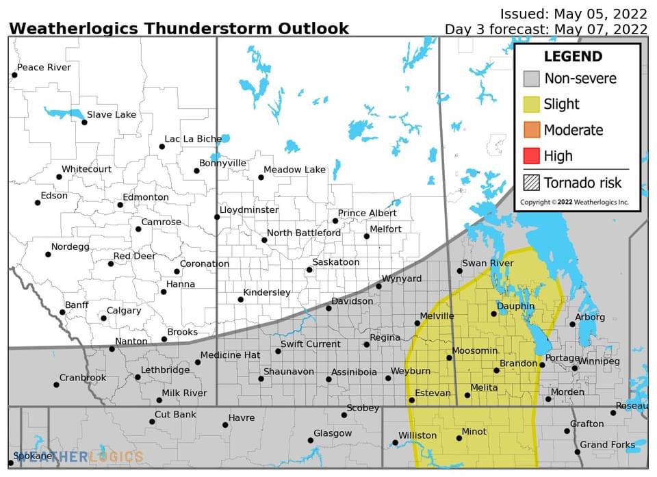
(Above: Weatherlogics.com Thunderstorm outlook for Saturday from Facebook https://www.facebook.com/Weatherlogics/photos/a.283252022103980/1445751339187370/?type=3 ). Heading into tomorrow a low pressure system will approach southern Manitoba, and as it cuts into a warm airmass there will be a risk for thunderstorm development during the latter half of the afternoon. A general 1,000 to 2,000 J/Kg of CAPE is expected in the southwest part of Manitoba. Of concern will be the shear, the environment will be enough to support supercell thunderstorms in the afternoon and evening hours in southwestern Manitoba. The risk for a tornado is there. A line of thunderstorms will then grow upwards and move on east northeast throughout the evening, likely weakening by the time it hits the red river valley.

The risks with these storms will be strong winds over 80km/h, large hail, damaging winds and a tornado are possible (during initial stages of development, tornado or 2 is possible. After this line moves into the red river valley the storms will likely weaken as they enter a weaker environment for thunderstorms. There’s a chance though that they will still impact the red river valley in the evening hours. Temperatures will soar into the low to mid 20’s for the day on Saturday, with humidity making it feel closer to 27C to 29C.
Saturday night a batch of showers will move up into southern sections of Manitoba, mainly the red river valley but most of the precipitation should be out of the province by the morning hours. Temperatures will likely drop into the low teens in the southeast with lows closer to the 10C mark in the southwest where temperatures in the morning will be in the high single digits.
Sunday and Sunday Night: Much of Southern Manitoba will expect partly cloudy skies on Sunday with a chance for showers. There’s a chance for showers to persist into the afternoon and early evening hours, with the risk of thunderstorms non severe mainly. Temperatures on Sunday are expected to rise into the mid to high teens in much of the region, temperatures will drop into the mid to high single digits in the southwest and in the southeast in the low teens.
During the week the GFS weather data model is hinting at another weak low pressure system affecting southern Manitoba Monday and Tuesday, bringing more unsettled weather with showers and thunderstorms likely. Temperatures will warm into the mid to high teens, if rain occurs temperatures will likely be cooler towards 10C. We’ll know more on Monday, long range forecasts are difficult to determine as is.
-Mike McGregor


No comments:
Post a Comment
Thank's for commenting on the blog, I appreciate it...