Hello everyone I am back with your weather update for the next 3 to 5 days, I've been quite busy over the last two and a half weeks I was also sick and down for the count with the old C19 virus I am able to provide a quick little synopsis about what's expected with our weather over the next few days especially as we head into the weekend the weather looks turn a little bit more unsettled and we could also have our first shot at More significant thunderstorms. Read on to find out more in this weekly weather blog from yours truly Mike McGregor.
Above window, simulation of the wind gusts associated with the thunderstorms this evening. Severe weather, is not likely.
The situation for today's weather pattern is we have a trough of low pressure or shortwave off in southwestern Manitoba which will kick off scattered showers and thunderstorms during the afternoon and early evening which will then move east throughout southern parts of Manitoba into the white shell by the evening. These scattered showers and thunderstorms will not be severe however given the fact that we have very strong winds at upper levels that these thunderstorms will tap into that and there is a possibility that some of these thunderstorms could have gusts from 80 to 90 kilometers an hour at times. Given the fact that there will be very little instability to work with these thunderstorms may only produce five to ten millimeters of rain once they impact your location. I coordinated with Justin with some information on this setup and he says that if any thunderstorm does impact the location it could have some very strong wind gusts there is a very low risk of hail associated with these thunderstorms. Regardless I'm seeing a likelihood of our high temperatures soaring into the low 20s for a majority of southern Manitoba once these thunderstorms move through during the late afternoon hours especially in the southwest these temperatures will drop well into the mid teens.
Tonight: as this shortwave moves back to the West in southern Saskatchewan I'm not seeing any significant weather moving into the rest of Manitoba during the overnight, remaining showers and thunderstorms which developed will likely be impacting the white the white shell and eastern Manitoba shortly before midnight. Areas to the west of the trough of low pressure especially in southwestern Manitoba will only see low temperatures between five and 8 degrees Celsius, areas to the east of the Trough of low pressure will see temperatures drop which is more seasonal for this time of year between 10 and 14 degrees Celsius areas that are in rural Manitoba may see temperatures closer to 10 degrees Celsius.
Saturday looks to be gorgeous with our daytime high temperatures soaring into the high teens and low 20s, mainly sunny skies are likely during the afternoon with Winds out of the West between 10 to about 30 kilometers an hour. No significant weather to talk about.
Saturday night will be the transition as an area of low pressure sits off to our South in the North Dakota's, this will be our weather maker for Sunday. Expect an area of increasing cloud cover with a possibility of some cloudy patches during the morning hours, Overnight low temperatures are likely to drop into the low to mid teens there is a possibility that some urban centres may be a bit warmer winnipeg is forecast to get a low of 16 degrees Celsius whereas areas outside the city may see temperatures between ten and fourteen degrees Celsius.
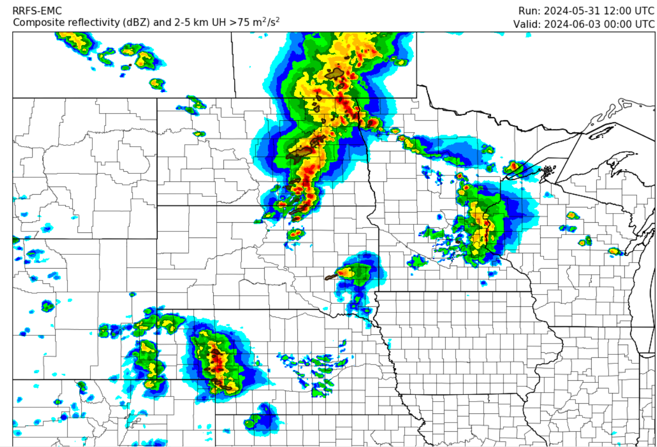
(Above): Thunderstorm complex likely to impact southern Manitoba on the day Sunday. We will let you know further updates as they come in.
Sunday: OK this is the one the weather starts to get a wee little bit Interesting and I've decided to use a little bit of some England accent to start this synopsis for Sunday, I promise you we're not gonna be getting weather that they would get in the United States or their countries what you would call monsoons. A strong frontal boundary looks to impact southern sections of Manitoba during the day on Sunday out ahead of it strong precipitable water values between one to 1 1/2 inches is possible which will be fuelled along a strong low level jet boundary and a general ML capes between five hundred and a thousand will be accessible for these thunderstorms. Models are suggesting a thunderstorm complex developing out ahead of a large broad trough that is sitting over northern Manitoba, only areas seeing that risk is in southeastern and S central Manitoba the highest risk for severe thunderstorms appears during Sunday afternoon and evening. Based on the latest data it appears that thunderstorms will be developing in northwestern North Dakota filling into southwestern Manitoba by the late afternoon hours there is a possibility that depending on where the front lines up that these thunderstorms could fire further to the south if that happens the thunderstorms could be impacting only areas of southeastern Manitoba including the Red River valley and the Winnipeg Interlake regions. Justin I Justin and I had a conversation and it appears that we could have be having a decent risk of another round of severe thunderstorms on Sunday as mentioned a few moments ago. The details of this event are still being ironed out by high resolution models so we will update you on the afternoon or evening on Saturday for this event. Regardless our high temperatures on Sunday will be rising into the mid to high 20s the majority of the Red River valley will be seeing high temperatures in the upper 20s with humidity or humid arcs values likely in the mid to high thirties.
Sunday night/ Clearing is likely with temperatures behind the front, dropping into the low to mid teens. Cloudy to partly cloudy skies are likely overnight .
The week ahead: Showers and storms are likely during the first half of the week with some remaining unsettled weather conditions. Storms are possible again on Tuesday though likely non severe in nature. Temperatures will remain seasonal with highs in the low to mid 20’s. Overnight lows in the mid to high teens.