Wednesday, February 29, 2012

February ends on a mild note with the winter of 2011-2012 being the 4th warmest on record!

(Left: Monthly Data for February from CYWG, showing all the weather elements including wind,temp, and barometric pressure. Notice how the temp fluctuated greatly between now and the first)
 
The month of February 2012 will end on a mild and calm note in Southern Manitoba, with highs today in between -10 and 0C under sunny skies. February will finish with an average temperature near -10C in Winnipeg, about 3.5C above normal. With both a very mild December and January the winter season of 2012 could go into the record keeping as the 4th mildest winter on record in and around Winnipeg, since records began back in 1872. Once Winter finishes Winnipeg's average temperature will be an astounding -10C, an amazing 5C* above the normal (-15.3C). That has been pretty much the same thing across the Red River valley and in SW MB (although a little warmer in those areas). This has been the 8th month of seeing above normal temperatures since July, It will likely not be broken in a while!

Top 5 warmest winters in Winnipeg (since 1872) Courtesy of Rob's blog

1. 1877-78 ............. -7.2C
2. 1997-98 ............. -8.2C
3. 1986-87 ............. -9.5C
4. 2011-12 ............ -9.7C
5. 1930-31 ............ -10.1C


As for the weather over the next week expect above normal temperatures, and below average precipitation as most of the systems will bypass us in the States. The GFS model is also hinting at single digit plus temperatures on the 6th for the Red River Valley. A more detailed outlook into our spring will be coming the second week of March, I have a feeling spring will come early!
Happy Leap Day Everyone!

Severe Weather Creates havoc in the states

Damage from an Apparent Tornado
 in the town of Harveyville in Wabaunsee County Kansas,
early this morning. 
As I told you last night there was a high risk for Thunderstorms and Tornadoes to occur. that's exactly what happened. Yesterday over 160 reports of severe weather were received by the National weather Service including 13 tornadoes in Missouri, Illinois, Kansas and Nebraska.
A potent storm system brought a string of possible tornadoes leaving at least 12 people dead and hundreds injured as it tore roofs from buildings, upturned trailers and created chaos across a broad area of the Midwest. Reports of Numerous homes in rubble, trees and power lines down and gas service out across Harveyville,Kansas.In Branson, Mo., there were at least a dozen injuries including people trapped in their homes. Also an apparent tornado moved through downtown Branson, heavily damaging the city's famous theaters.The owner of a 1950s-style diner in Branson said it looked like the tornado targeted the city's main tourism strip.John Moore owns Cakes-n-Creams '50s Diner in the middle of Highway 76, which runs through the city and is locally known as the Branson Strip. On Wednesday morning someone said that it appeared that the tornado moved down the entertainment district, jumping from side to side, before damaging the convention center.Then it moved across Lake Taneycomo, up what is known as Mount Branson and hit homes in a subdivision. As of Thursday all towns started picking up the peices. Head here for more details, on the storm: /http://kplr11.com/2012/02/29/branson-takes-direct-hit-from-tornado/

In total the NWS issued 65 Tornado warnings since last night. The Threat for Severe weather continues today in the northeast states with a moderate to high risk as highlighted by The Storm Prediction Centre. As well heavy snow continues on the northern part of this system.

Tuesday, February 28, 2012

Colorado low heading for the Northern Plains expect blizzard conditions to the north and Thunderstorms to the South

A potent colorado low is forecast to move across South Dakota into southern Minnesota Tonight and Into Tomorrow, bringing in it's path widespread snow with some off and on blizzard conditions to sections of Eastern North Dakota and Parts Of Minnesota. According to NWS in GF the worst of the conditions will be experienced near or south of Fargo with snowfall accumulations totalling up to, and well past 30cm. Strong north winds and blizzard conditions can be expected in these areas tonight and Tomorrow. Travel is not advised in these areas,expect highway closures in various regions including the I-94 corridor between Bismarck and Minneapolis. The Storm will also affect most of north and central regions of Minnesota. Minneapolis will be affected as well, with a nice wintry mix of snow,rain,freezing rain, ice pellets and sleet are likely. People planning to travel in these regions should prepare to change their Travel Plans. For southern Manitoba there is no threat for snow, Although if you live along or south of the border prepare for a few centimetres, (5 at the most).

As for the Weather In the southern plains it turns more summerlike.
 
With gulf moisture and some high levels of instability along the Colorado Low's Cold Front it is making a perfect recipe for Severe Thunderstorms. Already there have been numerous reports of severe weather across the states creating havoc for citizens, including reports of hail so deep in Mullen, NE that people needed snowplows. Severe Thunderstorms are still rumbling through various regions at the minute as well Tornado watches and warnings have been issued off and on throughout the daytime. Expect a bigger threat tonight as the main push of moisture forms in Arkansas.

Head here to track all the latest on radar:
http://www.ktiv.com/category/162528/stormtrack4?redirected=true

Blog Update Coming Tonight:

Hello everyone, If you are wanting to see the latest on weather in our area you will have to wait until tonight. I will be updating snowfall amounts from our previous storm, and giving information about a new snow threat that will affect the northern plains and parts of Manitoba Tomorrow. Stay tuned!

Saturday, February 25, 2012

System Coming for Manitoba and the Northern Plains

(NOAA Daily Weather Map for Sunday February 26th)

Considering this is my first major post on a storm system I'll try my best!
As expected Winter storm warnings are now in effect for Southern saskatchewan and North Dakota as an area of low pressure will move across the rest of saskatchewan before moving southeast through the northern plains and north dakota. Bringing with it a large area of widespread snow and blowing snow. Current Indications are that the heaviest of the snow will fall near or south of the International Border, while southern manitoba will be on the northern edge of the significant snowfall.

As for accumulations expect around 10-20 cm in north dakota, 5-10 cm across southern manitoba and the border, while in the northern section of the south half of the province expect accumulations nearing 2cm. We could see more if the system travels north. As for road conditions be careful if you are travelling stateside, as visibilities could be reduced to zero at times and prepare for blowing snow in open areas.
The snow should taper off by early monday morning in all areas, as the system moves east into Ontario.

Snowfall totals from Sunday across southern MB.. (Courtesy of Rob's Blog)

Winkler ............ 16 cm
Belmont ........... 13 cm
Miami .............. 12 cm
Altona .............. 10-15 cm
St Labre .......... 10 cm /SE of Steinbach/
Steinbach ......... 5 cm
Winnipeg .......... 4 cm
Oakbank ........... 2 cm


MINNESOTA
SEBEKA 6.0
BEMIDJI 5.0
LONG LOST LAKE 5.0
NEW YORK MILLS 5.0
SABIN 4.8
TAMARAC 4.3
MOORHEAD 4.2
BRECKENRIDGE 3.7
ROTHSAY 3.0
WADENA 3.0
WARROAD 2.2
AGASSIZ REFUGE 2.0
NORTH DAKOTA
LIDGERWOOD 9.0
VALLEY CITY 6.5
PENN 6SE 5.0
STARKWEATHER 5.0
PARK RIVER 4.5
GRAND FORKS SE 4.5
SARLES DHS PORT OF ENTRY 4.3
FARGO HECTOR 4.2
LANKIN 4.0
MICHIGAN 4.0
PEMBINA 4.0
GRAND FORKS NWS 2.2
HAVANA 2.0
GRAND FORKS AIRPORT 1.3

Wednesday, February 22, 2012

Colorado Low Brings the Most Significant Snowfall of the Season

(Radar Image from EC Historical Radar at 10 pm the 20th of February)

After a long stretch of dry weather, the snow drought was finally broken on Monday after a developing Colorado low moved into SE Manitoba bringing with it the most significant snowfall of the year. Although the area of precipitation was narrow it did bring a lot of snow to areas east of Winnipeg, we were unfortunately lucky and received very low amounts compared to the SE RRV. Areas like Lac Du Bonnet, Steinbach and the Whiteshell were affected by this storm system resulting in several municipal school closures on Tuesday, several car accidents due to slippery ice covered;snow covered roads in SE MB and around Winnipeg. As well power outages in SE MB because of all the heavy snow on power lines. Why didn't we pick up any snow? according to A Weather Moment Blog It is something we call a deformation zone (click  a weather moment blog for more info). It was a definitly significant snowfall, but how much did we get?
The Regions of Winnipeg: St.Boniface 6.25cm, Airport 2cm, Charleswood 4cm, Downtown 3cm, East 9cm, and River Park South 8.5cm. East RRV: Beausejour 15cm, Landmark 14cm, Indian Bay 17cm, Oakbank 13.4cm, Pinawa 15.4 cm, Steinbach 21cm, and in Woodridge a total of 20cm was received. Data from A Weather Moment blog. Overall over the next few days expect a few flurries and clearing conditions on Thursday with a return to seasonal weather.

Head To: Weather moment blog and Northern Plains Storm Summary for details on the Snowfall totals

Saturday, February 18, 2012

Update on the AO and Sea Surface Temperatures

While I was browsing through my sites I found this AO Index from and I decided create a writeup on it here it is: After half a month of below seasonal temperatures brought on by the Negative AO, we are now seeing it return to the positive side about (+1) AO.(See AO index to the left). This will allow all of the cold air to be locked up in the arctic rather than be pushed down south into our region. All in part due to a strong arctic jet stream and higher air pressure that will help keep all of the cold air locked up in the arctic. This means that the overall trend for our part of the province will be above seasonal weather and an increased chance for precipitation. In other areas across North America the pattern will be different wetter weather can be expected in Alaska, Scotland and Scandinavia. While the states could undergo drier conditions and a reprieve from the recent storm systems that have gone through the West. As for the rest of Canada cold conditions can be expected in Newfoundland with higher than normal snowfall amounts.While Quebec,Ontario,Saskatchewan,Alberta,Manitoba, and British Columbia can expect above normal temperatures and normal precipitation amounts.


(Left: The Difference between positive and negative AO)


As for the Sea Surface Temperatures we are remaining on the La Nina side of things (see sea surface index to the left) and are pinpointing over the next few weeks and into the spring months we could see a return to Neutral conditions. This will effect our weather pattern by having times of cold and warm periods going with a mix of moist and dry conditions. An example would be 2008 that I can remember when our overall weather pattern was a mix of dry and wet weather. Although the La Nina we are having now will be affected dramatically by the positive AO. Check out this page for details on forecasts and conditions on sea surface temperatures:http://www.cpc.ncep.noaa.gov/products/precip/CWlink/MJO/enso.shtml 

Sunday, February 12, 2012

Back To Seasonable Weather as our Snow Drought Continues


(Top Left: 2012 winter snowbanks, Bottom Left: 2011 winter snowbanks From Winnipeg Free Press) 

After a week of unseasonably cold weather we will now be welcomed with warmer and more seasonable weather for this time of year, as the area of arctic high pressure moves east towards the Atlantic provinces. Temperatures will rise towards the minus single digits for the middle of the week and maybe even close to the freezing mark on Wednesday. The main story of the coming weeks will be the continuning snow drought. All weather models suggest the main areas of precipitation being far away from the Province of Manitoba either all the way up north, or all the way down south. Snowfall has been rare this winter for Winnipeg and The RRV unless you go north, overall we have had well below normal precipitation for the past couple months. From the beginning of winter (Dec 22) all the way through to (Feb 12) we have had about 48 cm of snow, compare it to last year this time where we had 116.6cm of snow.This time last year we were preparing for a major flooding scenario, this year a potential drought.
(Some of the data was taken from Rob's Blog)

(Right: Brett Andersons ECMWF Weekly model


As For the coming weeks expect a few odd cold days, mixed in with several warm periods. Although the Weekly ECMWF model is pointing towards an early start to spring with very warm weather into the beginning of march, as the AO switches over to postive. Who knows spring may just be around the corner. Stay Tuned I'll have my spring outlook coming up in mid march as from the help of Theweathernetwork...........

Sunday, February 5, 2012

Back to Cold Weather!


(Left: GEM-GLB surface analysis forecast 96hr Friday Feb 10th,2012)

After a nice few days with warm temperatures across the prairies, expect a change to cooler than normal weather conditions for the beginning of this week.
A cold front is expected to swing south over the province tonight and early tomorrow morning, bringing with it a chance for some light and local blowing snow across the south part of the province. With the passage of the cold front by Monday afternoon skies will clear and winds will shift towards the north, it could become quite strong (60km/h at times), that will aid in cooling our temperatures throughout the day.Temperatures will moderate on Tuesday and Wednesday, before we see temperatures that will be colder with high windchill values for the end of this week and into the weekend with nice conditions. The arrival of a high pressure system will promote the cold temperatures, as it sits sit over the prairies for a few days. This will allow for our temperatures to fall well below normal. Expect it to clear out by the beginning of next week, giving us a chance to finally get back to our normal pacific weather that we have been experiencing all winter. Till then you will have to brave the cold!

Stay up to date on how cold the weather will get here.......

Thursday, February 2, 2012

Ground Hog Day Predictions

Find Out What the Groundhogs had to say today, are we in for an early spring?http://www.cbc.ca/news/canada/manitoba/story/2012/02/02/mb-willow-woodchuk-ground-hog-spring-winnipeg.html

Severe Weather Outbreak Possible in The Plains Tomorrow!

Details on the potential outbreak for tomorrow,have a look!
http://www.tornadovideos.net/component/content/article/1-latest-news/1415-severe-weather-22-23-much-needed-rain-for-the-plains-coming-who-stole-the-dominator

And

http://www.spc.noaa.gov/products/outlook/day2otlk.html

Another Night of Fog and Low Visibilty, More Warm Weather On the horizon

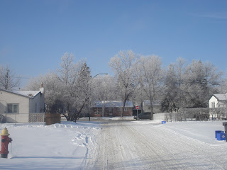
With a Combination of warm snow cover, light winds, high humidity and clear skies we can expect another round of fog, that has pretty much been the same scenario over the past couple of days for much of the Red River Valley and Winnipeg. Areas of dense fog with near zero visibility at times are expected to develop late this evening and continue through till Friday Morning. Although with increasing clouds tonight ahead of a frontal system the fog may not be as bad as the past two nights. Overall fog is still expected to develop.Even though the fog has been a cause for traffic problems it seems to be the creator of these picturesque trees or what we call "hoarfrost"
Just take a look at this picture I snapped outside my house this morning what a beauty eh?
Expect these scenes to become a reality over the next few days as the fog will aid in keeping these beautiful formations, so if you haven't got the chance to take a picture, you are not quite out of luck yet.
Expect an end to the foggy conditions by Sunday, by then a ridge in the jetstream will form across the prairies allowing for a more southerly flow, that in turn could push our temperatures up to record breaking territory. The warmup won't last long though, with another possible push of cold air by next week.

Wednesday, February 1, 2012

January 2012 ends as the 3rd warmest on record!

It has been a warm and very dry one one here in Winnipeg and across Manitoba this January, even though La Nina is still going full power, a strong Jet Stream is aiding and keeping the flow of warm air into our province.

So how did we fare? Well we came in as the third warmest January on record with an average daily high temperature of about -6C, while the actual average high temperature for January is about -13C. The beginning of January did feature a great start with warm weather from the 1st all the way through to the 13th, followed by a brief cold spell with another warm spell before we got hit by a huge blast of arctic air from the 16th to the 21st. Temperatures in this period were in between -15C and -24C.The month of January ended with warm weather and some record breaking temperatures, which continued through to the beginning of February. As for snowfall totals the highest we received last month was only about 10cm on the 5th when a quick system brushed by us. On average we were well below normal in getting precipitation, that trend looks to continue.

It has been another story up in Alaska where temperatures in some places have dipped well below -50C in some cases -60C windchills.

Featured Post

Major Rainfall first of the season for Southern Manitoba.

Hello folks of southern Manitoba this is another weather update, we have some interesting weather on the way a low pressure system developin...