Warm Temperatures will continue to make an appearance in Southern Manitoba as we will rise into the high 20 Degree range every day for the rest of the week. We will continue to see active conditions as multiple systems move over the province for the second half of the week.
Another Powerful Low Pressure System is set to make an entrance into The Province on Thursday Night as it pushes showers and thunderstorms out ahead of it into SouthWestern Manitoba that will last through until the morning when things clear out. The Low will sit over Southern Manitoba on the day Friday likely giving an enhanced severe weather threat given the instabilty that will be in place. Severe Storms with Large hail and damaging winds cannot be ruled out. There will be a chance for heavy rain/thunderstorms on Friday Night as the backside of the system wraps around. Saturday will be fairly cool at around 20C, as cool air filters in behind the system. Although the rest of the weekend will be a lot nicer with temperatures rebounding back up to 30 degrees.
Have A great Second Half of your Week!
Weather Information For All Of Southern Manitoba. With A Focus On The Winnipeg Region and Vicinity. (Follow Me On Twitter @SouthMBWeather)
Showing posts with label Severe Weather. Show all posts
Wednesday, August 1, 2012
Monday, July 30, 2012
July to End Hot and Stormy
After a round of active weather the past couple of days in Southern Manitoba, we can expect a short reprieve with a return to hot and humid weather for the end of July.
![]() |
| A look at Temperatures for the last day in July at 850MB, just add 13C onto the temperature legend you see in your region on the map. |
The month of July will decidedly end just as it started, in the same fashion with the never-ending very warm weather. Sunny Skies and temperatures anywhere from the high twenties to low thirties can be expected for the rest of the day although there may be some cloudcover from general daytime heating. Nothing like what went on Yesterday through the Red River Valley. Winds will make for a comfortable breeze as they blow out of the Northwest, likely blowing some smoke from any ongoing Forest Fires in northern Manitoba southwards into the region. The night ahead will also be fairly nice as winds continue to blow out of the northwest in various locations, any leftover cloudcover will clear as we lose daytime heating. When we lose daytime heating our temperatures cool off so as a result we expect our temperatures to cool down to around 17 degrees tonight in Winnipeg with the outlying regions in the mid teens.
Tomorrow will be a similar day, although we will have to contend with some thunderstorm activity mainly in Southwest Manitoba and the Western Red River Valley as another system decides to slide through the region. Currently it is looking like some of the storms could end up being pop up scattered thunderstorms in the afternoon and evening hours as daytime heating and the system plays a role in triggering the storms. Given that we will have high amounts of instability in place I cannot rule out the possibility of some severe thunderstorms once they get going. By Mid Evening things could turn into a MCS once the storms bundle and organize themselves, this means that the Red River Valley and eastern Manitoba would be at threat as they would move Eastwards from the point of there origination and create threats of Strong Winds in Excess of 100 km/h, Heavy Rain, Intense Lightning and Large Hail. It is unclear as to what exactly what will happen with the Thunderstorm Complex or MCS at this moment, so I will keep everyone informed about the situation as we get closer to the evening hours Tomorrow. As for tomorrow's Temperatures they will once again feel hot and muggy as we approach or surpass the 30C Degree mark in Manitoba Tomorrow.
Friday, June 15, 2012
Another Weekend of Unsettled Weather
(Some Information Provided by Brad From A Weather Moment)
Today will be another beautiful day for the start of the Red River Exhibition as temperatures near the mid 20C range anywhere in the southern part of the province, with very little cloud cover to contend with. Although things are about to turn active for the weekend with the arrival of more low pressure systems that will move over our region.
![]() |
An area of rain/storms will form in SE Sask, Western North Dakota tonight at 6pm and it will drift eastwards throughout the night.
|
An area of low pressure is expected to trek eastwards across the prairies and northern plains today, as a result things will become more favourable for the development of thunderstorms tonight. As the system tracks into SW Manitoba and Western North Dakota tonight, storms should have very little issue popping up. With decent instability, the storms should quickly grow into an area of rain with embedded thunderstorms and likely trek East-Northeast. The area of rain will get to the SW by late evening, Red River Valley late overnight and get through to eastern Manitoba by the morning and afternoon. With little LLJ influence in place it will likely keep the thunderstorm threat to a minimum with the rain that pushes through. Although the odd rumble of thunder cannot be ruled out. Some Models are forecasting up to near 10 and 15mm of rain over the next 3 to 6 hours. This system looks a lot similar to last weekends storm system, so it may end up prompting more stormchasers to head out if severe weather develops. As the area of low pressure tracks through the rest of Manitoba tomorrow, we will see the chance for showers and thunderstorms through much of the Red River Valley in the afternoon. Chances will be higher North of Morris, that would include Winnipeg and areas North.
![]() |
| Another Round Of Storms, Possibly Some Severe On Sunday |
The threat of severe weather returns to Southern Manitoba on Sunday as another powerful low pressure system moves into the area. Dewpoints will rapidly climb up into the high teens/low twenties on Sunday, especially in regions of SW Manitoba as a powerful southerly flow develops out ahead of the incoming storm system. CAPE values will likely climb past 2000 J/Kg with decent shear. Tornado potential exists and looks to be near the Western Red River Valley, including Pilot Mound,Crystal City, Manitou, Pembina Valley Provincial Park, Morden, Winkler, Altona, Emerson and Morris. All areas South and West of Winnipeg. The closer to the USA border you live, the greater the risk for tornado producing Supercells. As the storm system travels eastwards into the Red River Valley by evening things should blow up fairly good, with widespread thunderstorms growing quickly into an MCS. Damaging Winds and large hail will most certainly be a threat for areas in the RRV. Sunday's forecast is sensitive to the systems speed. If it ends up being slower everything will be further West, If faster everything will be further East.
Details on the coming storm systems will be available on Twitter and in my Blog Commentary
Friday, June 8, 2012
Significant Tornado Threat In Southern Manitoba Saturday
A slow moving area of low pressure pushing into our region this weekend will set the stage for the potential of supercell thunderstorms capable of producing dangerous flooding, extremely large hail, damaging winds and possible tornadoes.
![]() |
| A look at the slow moving low pressure system that is set to roll into Southern Manitoba on saturday with the Severe Thunderstorm coverage risk map. |
The main surface low starts to move into our area on Saturday, bringing a warm front up from the Northern plains of North Dakota into Southern Manitoba.
So what will the atmosphere have available for the Storm's Tomorrow? Looking at Data Provided by Brad from A Weather Moment
- Moisture: Plentiful. Surface dewpoints will be sitting near 20°C across Southern Manitoba, with 850mb dewpoints pushing up towards 15-17°C. This deep layer of moisture will provide plenty of energy for storms to work with.
- Instability: The major inhibition to storms will be a layer of warm air at 700mb. Temperatures will climb to 10-13°C at 700mb on Saturday morning, however cooler air will push in later in the afternoon, helping destabilize the mid-levels. LI values of -8 to -11, combined with CAPE values anywhere from 2500 J/kg to 5500 J/kg are evidence of an extremely unstable atmosphere.
- Shear: With a decent upper-level jet pushing in through the day, most areas across southwest and south-central Manitoba will see bulk shear values increase to 30-40kt by evening.
- Trigger: A warm front draped across Southern Manitoba will be strong enough to initiate convection in the mid-to-late afternoon as the cap begins to erode.
Overall models are having a hard time deciding on the speed of this system, but they agree that it has the potential to produce dangerous supercell thunderstorms capable of producing tornadoes. The greatest difficulty is predicting where they will form, current indications are that the greatest threat for tornadoes will likely occur in a the region from North of grand Forks towards and north of the Canadian Border. This would likely include the Red river Valley and into Winnipeg and North. Although if this turns out to be different SW Manitoba might be under the gun, for tornadoes. So overall here is the Risk Map for Saturday:
![]() |
| The Latest Storm Prediction Centre Severe Weather Outlook, areas hatched in red indicates the best chance for severe thunderstorms. |
According to Brad "large MCS will likely develop as the whole system lifts northwards overnight, which will continue to provide a severe weather threat in the form of strong winds and large hail. It will push through the RRV by Sunday morning. We may see the threat for another round of thunderstorms on Sunday afternoon, however they are not expected to be severe. Things will finally cool off on Monday as the main upper low moves through and draws in cooler, dryer air from the west.
Wednesday, May 23, 2012
Back to Nicer Seasonal Weather
After a crazy few days across the Southern Part of the province, we will be in for some calmer seasonal days before the next system moves through our area on the weekend. We will see thing's clear out this morning with our temperatures going up to inbetween 15 and 20C. We will see only a slight chance for showers in all regions this afternoon, they should be able to clear out by this evening. Overnight lows will be in the single digits in the South, near 5 and 10C. Thursday and friday will be much nicer with overall conditions forecast to be a mix of sun cloud towards sunny conditions, with a chance for showers as the system we experienced last night moves out of our province. Forecast temperatures will be near 20C over the next few days, before another significant storm system moves into our area this weekend. Hopefully not during the Teddy Bear Picnic.
Monday, May 21, 2012
Another Round of Stormier Weather Set to Return to Southern Manitoba Tomorrow
After a fairly rainy day with mild temperatures we can expect more possible showers overnight, before more unsettled weather pushes in and lasts through midweek.
![]() | |||||
| Projected Dewpoint Temperature in Southern Manitoba Tomorrow at Midnight, when convection is forecast to roll through the region. |
The upper low will move east on Wednesday, allowing for fairer conditions to take place followed by possible showers and storms by the end of the week.
Update May 22nd,2012
Severe thunderstorms are possible today as a cold front will slide through North Dakota allowing for an area of convection to occur by mid afternoon, which may be severe at times. The storms will likely lift north into Southern Manitoba as the front moves eastward. Overall Southern Manitoba will be at threat for storms this evening, for hail, damaging winds, and intense lightning. (This graphic above from Brad's Blog shows the potential).
Friday, May 18, 2012
More Showers and Thunderstorms on the way for Parts of southern Manitoba
While temperatures will soar to near 30 degrees today, the Red River Valley should be prepared for showers and possible thunderstorms to develop by mid towards late afternoon. This will result from a low pressure system that will move into the area and tap into heat and moisture.
According to A Weather Moment " A strong capping inversion will be in place over the Red River Valley, heat and moisture being pumped northwards will be trapped at the surface, allowing our temperature to soar to the 30°C mark and pooling moisture that will push our dewpoints up to around 15°C". Today will will be a glorious day throughout the morning and early afternoon. Although conditions will start to breakdown by late afternoon as a surface low lifts north into Southern Manitoba.
According to A Weather Moment "The surface low will travel along a pre-existing surface trough and be supported by a shortwave ejecting northeastwards from the main upper trough, still anchored through Montana and Wyoming. As well With the heat trapped near the surface, the Lifted Index is expected to drop to the -2 to -8 values, with the lowest values running along a line from Gretna, MB to Bisset, MB and increasing to the southeast of that line. The heat combined with ample moisture is also expected to produce high CAPE values generally from 2000 to 3000J/kg. Increasing mid-level lapse rates with the approach of the shortwave will provide enough destabilization to erode the capping inversion through the afternoon and allow showers and thunderstorms to develop along and ahead of the warm front, initially concentrated near the triple point of the system. The showers and thunderstorms will expand in coverage as the evening progresses and the low-level jet intensifies."
The severe weather threat is well defined says brad from A Weather Moment,"as EHI values rise to between 1.5-2.0 by late afternoon, which when combined with the presence of 30-35kt of bulk shear certainly presents the chance for supercell storms to develop. A few things hamper my excitement, though:
![]() |
| Temperature outlook from the weathernetwork |
According to A Weather Moment "The surface low will travel along a pre-existing surface trough and be supported by a shortwave ejecting northeastwards from the main upper trough, still anchored through Montana and Wyoming. As well With the heat trapped near the surface, the Lifted Index is expected to drop to the -2 to -8 values, with the lowest values running along a line from Gretna, MB to Bisset, MB and increasing to the southeast of that line. The heat combined with ample moisture is also expected to produce high CAPE values generally from 2000 to 3000J/kg. Increasing mid-level lapse rates with the approach of the shortwave will provide enough destabilization to erode the capping inversion through the afternoon and allow showers and thunderstorms to develop along and ahead of the warm front, initially concentrated near the triple point of the system. The showers and thunderstorms will expand in coverage as the evening progresses and the low-level jet intensifies."
The severe weather threat is well defined says brad from A Weather Moment,"as EHI values rise to between 1.5-2.0 by late afternoon, which when combined with the presence of 30-35kt of bulk shear certainly presents the chance for supercell storms to develop. A few things hamper my excitement, though:
- Bulk shear isn’t really all that impressive; the really good shear moves through Western Manitoba through the day today, lifting northwards into the Interlake. The shear diminishes to the SE and isn’t particularly strong where the greatest CAPE is. When it comes down to it, it’s likely that we’ll end up with marginally strong shear on top of marginally high CAPE this afternoon, with the most favorable conditions missing each other.
- CAPE values may be too high. The NAM & GFS have been forecasting dewpoints slightly higher than have materialized. The amount of energy for storms to work with is going to be heavily dependant on the dewpoints that develop this afternoon, and if they don’t make it as high as forecast then we’ll be seeing weaker storms.
- Too many storms. With so many marginally severe features, we may see quite a few showers and thunderstorms develop this afternoon as the cap erodes. If too many fire off, then it will be difficult for any one storm to oragnize itself into anything that poses a severe weather threat."
![]() |
| Severe Weather threat as highlighted by Brad |
Overall everyone should be on the lookout for severe weather and or Storms, as well updates will be available on Twitter.
Friday, April 13, 2012
Dangerous and Life threatening Severe Weather Outbreak possible on Saturday for the Great Plains
People who are living in the Midwest, tomorrow could be a very dangerous scenario. The Storm Prediction Centre has issued a high risk severe weather threat for most of Oklahoma, Kansas as well as parts of Nebraska and Iowa. The cities that are included within the high risk region include cities such as Oklahoma City, Wichita, Lincoln, Norfolk and Tulsa. Dr Jeff Masters quotes "Warm, moist air flowing northwards from a Gulf of Mexico that has record-warm
waters will collide with cold air funneling down from Canada, creating a highly
unstable air mass capable of creating strong thunderstorm updrafts. An
impressive upper-level low, accompanied by a jet stream with 105 - 125 mph winds
at middle levels of the atmosphere, will create plenty of wind shear, giving the
air the spin it needs to form tornadoes." This is the second time this year the SPC has issued a high risk outlook. Any tornadoes that form could be violent, long lived and long tracked. This could possibly mean F4' and F5' tornadoes for people living in the high risk region. Please stay tuned to your weatheradioes and pay close attention to the weather in your region.Update Saturday April 14th,2012
All of the parameters still appear to be in place for a significant tornado outbreak throughout this afternoon and evening in the plains. According to Zoom Radar Blog "A 100 KT+ jet streak is anticipated to overlap an unstable air mass, where dew points should be well into the 60s and CAPE values will range from 2000-3500 J/Kg. The entrance of that jet streak will bring along 0-6 effective bulk shear values in the 70 KT range, which is more than sufficient (to say the least) to produce rotating super cells". The only thing that has changed is the risk map produced from the Storm Prediction Centre, as they have modified the high risk outlook to cover a more widespread area stretching from parts of northern Nebraska south towards the Oklahoma City area, which is not good for some.
What is more scary the tornado probabilities the SPC put out for today and tonight. They have placed a 45% zone over top of the state of Nebraska and Kansas (of there being a tornado within 25 miles of a point). I believe the last time the SPC issued a 45% region was last year during the super outbreak in Alabama. Before that event, their wasn't really any times that the SPC had forecasted a high risk. According to Zoom Radar blog this is how thing's should develop "The convection should initiate in Nebraska late this morning or early this afternoon around the low, where the forcing is the greatest. Initiation could be earlier than was anticipated yesterday. Models suggested showers would be moving through Nebraska this morning along the warm front; however, that’s not the case. What this means is the surface should destabilize quicker than expected, and storms will fire sooner as a result.![]() |
| A current look at some of the storms at 2pm CDT |
Head to A Weather Moment blog for details on the Tornado Outbreak Aftermath
Tuesday, March 27, 2012
Second Round of March Thunderstorms Rumble Through Winnipeg and some parts Of Manitoba
![]() |
| Radar Image from EC at 0000 UTC |
At the same time there was a cluster of storms forming Near the Black Hills in NW South Dakota, at the ND/SD and CO border. This was the main focus for areas in Southern Manitoba later in the night, as they would be carried North along with the Low Pressure System and the fast flowing LLJ. At approx 12am the storms transitioned into a multi cellular line of storms as they crossed the border into North Dakota generating reports of quarter size hail, gusty winds in excess of 50 mph, intense lightning, and very loud thunder. As a result the NWS issued severe thunderstorm Watches for the Western Half of North Dakota as they travelled northward. Unfortunately the same line of storms split up as they were about to cross the Manitoba border, leaving the more intense activity on more of the western edge of the line. Areas anywhere in between Melita and Winkler were affected. This left the less intense activity on the eastern edge where only showers were falling.
This whole story reversed as the storms crossed the border, in this case the storms on the western edge in areas like Killarney transferred all of the convective energy to the east allowing for more potent storms to form just south of Winnipeg. In this case the storms that formed started travelling to the N and developed rain with lots of lightning ,allowing for us in Winnipeg to see our second thunderstorm event of the year. There were a few reports of dime size hail in St.Vital for 5 to 10 min during the storms. For those who were in and around the storms it sure did bring a really good quality lightshow, one that we won't forget soon. Although all of that lightning did come at a cost, a lightning bolt was reported to have struck a transformer in the River Park South area resulting in 100 people being left without power. The power was restored a short while later, that is a great example of how powerful one flash of lightning can really be whether it be close or faraway. (Right: Youtube- Storm In Winnipeg)
Monday, March 26, 2012
First Major Storm System of the year!
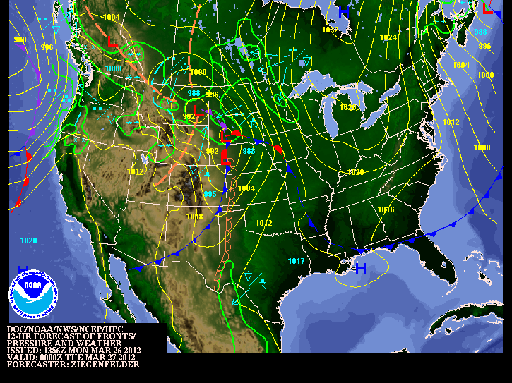
After a short period of warm weather over the past few weeks, it's time to head back to reality. Our first significant storm system of the year will roll through the southern part of Manitoba tonight and throughout tomorrow. This system will follow the cool and seasonable weather we have experienced over the past few days. Let's hope you are starting to get used to what spring really feels like in Southern Manitoba.
NOAA 12Z Wx Map
A strong southeasterly wind will continue to blow out ahead of the low pressure system throughout the rest of the day today. Winds are forecast to be in the range of 40 to 60km/h across the Red River Valley. Later this afternoon spotty showers as well as the odd thunderstorm may develop in general rainfall amounts will be insignificant (small) with only a couple millimetres expected.
This storm system will really get going tonight and into tomorrow morning as strong to severe thunderstorms are expected to develop in the Dakota's. These thunderstorms will be initiated by a potent area of lift asscosiated with the low pressure system. Also a powerful low-level jet stream will provide a 2nd source of lifting and a strong moisture inflow. The result of the LLJ tonight will be the fast movement of air into the Northern Plains and Parts of Southern Manitoba. That movement of warmer and moist air into our area including the Red River Valley will provide support for some strong storms tonight. The possibility for severe thunderstorms definitely exists in portions of North Dakota. It is unlikely we will see any severe storms in Southern portions of the province, although a few stronger storms may sneak across the border. Some with the potential for hail and strong wind gusts, nothing even close to what we experience in our summer months.
The storms that form tonight in North Dakota will eventually move into southern manitoba during the overnight hours, regardless of their strength. Any Storms that travel up from the south will mainly produce heavy rainfall. Accumulations will be in the 5 to 10mm range, although higher in areas where thunderstorms pass by.
Most of the precipitation will be over and done with in Winnipeg and the Red river Valley by Morning, with a risk for storms. Mainly cloudy conditions will persist during the day tomorrow. However, people who live in southwestern Manitoba wont be quite as lucky. Rain will change over to flurries by Tuesday night. The bulk of the snowfall will occur to the north such as riding mountain areas, with general amounts ranging from between 5 to 10 cm. Higher amounts can be expected due to regional upsloping.
Storm total rainfall amounts in Southern Manitoba will vary from place to place. Some estimates are listed below:
- Winnipeg: 10 to 15mm
- Steinbach: 10 to 20mm
- Brandon: 10 to 20mm
- Portage la Prairie: 10 to 15mm
Friday, March 16, 2012
Record Breaking Weekend Ahead!
Southern Manitoba will see a potentially record breaking weekend ahead with potentially the first big heat wave of the year! Since the week began we have broken 3 record temperatures and at least 4 other records are expected to be broken over the next few days. In fact there is also a chance that we will see the warmest weather ever experienced in March at the beginning of next week!

March has been surprisingly warm this year, with temperatures anywhere from 10 to 20C above the normal, after a unpleasant snow storm started the month with more than 15 cm of snow in some parts of the province. With most of the snow around still forecasters had a lot of uncertainty as to how warm the weather could get. The extremely warm air aloft, the warm sun, and a few days of having a southerly breeze has done a great deal in melting most of the snow! In fact just look at how much melted in North Dakota and in our Part of the Province (Left; Top: March 02,2012 snowcover vs. Bottom: March 15,2012 snowcover)There is still some snow left in SW MB. As well as Ice left to melt on the Manitoba Lakes, Rivers, and creeks before we can call it officially all melted. Although there hasn't been enough of it to keep our temperatures back. As a result we have managed to break several temperature records so far this week and that trend looks to continue at least for thenextcouple of days.On Sunday we broke a record that was set back in 1981 at 12.5C making the new record temperature 12.8C, On Monday we broke a record that was set back in 1922 at 7.2C putting in it's place a temperature of 9.7C. Last but not least on Thursday we broke a record that was set back in 1927 at 11.1C making the new record 14.4C
So what exactly is causing this unexpected warmth? As depicted on the map to the right a area of low pressure and a strengthening southerly flow will begin to allow plenty of heat and maybe some moisture into the northern plains including Minnesota, South Dakota, North Dakota, as well here in Manitoba. The Warmth will extend all the way up north into Norway House.
Forecast High's for the next few days!
The top 3 hottest days ever recorded in Winnipeg in March are:
Data and some info is in part from AWM Blog

March has been surprisingly warm this year, with temperatures anywhere from 10 to 20C above the normal, after a unpleasant snow storm started the month with more than 15 cm of snow in some parts of the province. With most of the snow around still forecasters had a lot of uncertainty as to how warm the weather could get. The extremely warm air aloft, the warm sun, and a few days of having a southerly breeze has done a great deal in melting most of the snow! In fact just look at how much melted in North Dakota and in our Part of the Province (Left; Top: March 02,2012 snowcover vs. Bottom: March 15,2012 snowcover)There is still some snow left in SW MB. As well as Ice left to melt on the Manitoba Lakes, Rivers, and creeks before we can call it officially all melted. Although there hasn't been enough of it to keep our temperatures back. As a result we have managed to break several temperature records so far this week and that trend looks to continue at least for thenextcouple of days.On Sunday we broke a record that was set back in 1981 at 12.5C making the new record temperature 12.8C, On Monday we broke a record that was set back in 1922 at 7.2C putting in it's place a temperature of 9.7C. Last but not least on Thursday we broke a record that was set back in 1927 at 11.1C making the new record 14.4C![]() |
| 850mb Temp from the GEM REG Model |
So what exactly is causing this unexpected warmth? As depicted on the map to the right a area of low pressure and a strengthening southerly flow will begin to allow plenty of heat and maybe some moisture into the northern plains including Minnesota, South Dakota, North Dakota, as well here in Manitoba. The Warmth will extend all the way up north into Norway House.
Forecast High's for the next few days!
- Today March 16th: 21C
- Tomorrow March 17th: 17C
- Sunday March 18th: 26C
- Monday March 19th: 26C
The top 3 hottest days ever recorded in Winnipeg in March are:
- March 27, 1946: 23.3°C
- March 23, 1910: 22.8°C
- March 28, 1938: 20.6°C
![]() |
| Overnight CAPE of 2000 J/KG CAPE from NAM is forecast on Sunday |
With the warm weather forecasted and highs in the 20's It looks like we will likely break the all time warmest March temperature Today, Sunday and Monday. There is one more thing that will also be a possible weather maker on the weekend "Thunderstorms"! There is a possibilty into sunday night into monday where we could see some overnight thunderstorms or what we call nocturnal thunderstorms. What we look for when forecasting thunderstorms include Moisture,Instability, Shear, and a Trigger. Here is a breakdown of what we are looking at for Sunday Night. For Moisture: Dewpoints are forecast to be near 15C, Instability: Models vary but we could see 2000J/KG of CAPE,Shear: 50-60kt of 0-500mb bulk shear and for a Trigger we have an advancing area of low pressure from the states that could provide enough energy to get things going. I will keep tweeting Via Twitter and provide you with the latest on the temperatures and thunderstorms!
Data and some info is in part from AWM Blog
Saturday, March 3, 2012
String of deadly Tornadoes hits the United States
![]() |
| Setup for the tornado outbreak of March 2nd,2012 |
Later On in the afternoon a long lived Tornadic Supercell Formed just north of the Ohio river dropping tornadoes in communities of southern Indiana including Marysville and Henryville.The Community of 1000 people in Marysville was completely destroyed, the nearby town of henrysville was also destroyed. One resident describes the scene like a war zone! "Cars were thrown across the road,street signs were down, homes were decimated, the metal in the ground, the railings for the roads were completely ripped out of the ground and some were in cars. As well Semis and Trucks were overturned." Many other communities were affected by the tornadoes in Indiana during the afternoon hours.
![]() |
| Radar Image of the tornado entering West Liberty,Kentucky |
![]() |
| Tornado Damage in West Liberty,Kentucky |
Once the evening hours came around (approx 5pm CDT) another Tornado extensively damaged the downtown region of West Liberty,Kentucky.This Time it was affected by an EF3 Tornado, with winds in excess of 220 km/h.
Data Courtesy of Accuweather.Weathermatrix.com
Death Toll: 31 and rising*
States Affected: 15*
Total Warnings: 660
Area Covered: 38,000 sq. mi.
Tornado Warnings: 281
Severe Thunderstorm: 356
Lightning Strikes: 156,399
Total Spotter Rpts: 809
Tornado Reports: 95
Funnel Cloud: 51*
Wind Reports: 246
Hail Reports: 417
States Affected: 15*
Total Warnings: 660
Area Covered: 38,000 sq. mi.
Tornado Warnings: 281
Severe Thunderstorm: 356
Lightning Strikes: 156,399
Total Spotter Rpts: 809
Tornado Reports: 95
Funnel Cloud: 51*
Wind Reports: 246
Hail Reports: 417
Overall It was a significant Tornado Outbreak, one we will not forget for a long time! there were many stories of survival, courage, and miracles during the recovery efforts, yet they still continue. I can guarantee you those stories will be featured on the news over the next few days. To find out how you can help please visit: http://www.redcross.org/contactus/
Saturday, February 25, 2012
System Coming for Manitoba and the Northern Plains
Considering this is my first major post on a storm system I'll try my best!
As expected Winter storm warnings are now in effect for Southern saskatchewan and North Dakota as an area of low pressure will move across the rest of saskatchewan before moving southeast through the northern plains and north dakota. Bringing with it a large area of widespread snow and blowing snow. Current Indications are that the heaviest of the snow will fall near or south of the International Border, while southern manitoba will be on the northern edge of the significant snowfall.
As for accumulations expect around 10-20 cm in north dakota, 5-10 cm across southern manitoba and the border, while in the northern section of the south half of the province expect accumulations nearing 2cm. We could see more if the system travels north. As for road conditions be careful if you are travelling stateside, as visibilities could be reduced to zero at times and prepare for blowing snow in open areas.The snow should taper off by early monday morning in all areas, as the system moves east into Ontario.
Snowfall totals from Sunday across southern MB.. (Courtesy of Rob's Blog)
Winkler ............ 16 cm
Belmont ........... 13 cm
Miami .............. 12 cm
Altona .............. 10-15 cm
St Labre .......... 10 cm /SE of Steinbach/
Steinbach ......... 5 cm
Winnipeg .......... 4 cm
Oakbank ........... 2 cm
MINNESOTA
SEBEKA 6.0
BEMIDJI 5.0
LONG LOST LAKE 5.0
NEW YORK MILLS 5.0
SABIN 4.8
TAMARAC 4.3
MOORHEAD 4.2
BRECKENRIDGE 3.7
ROTHSAY 3.0
WADENA 3.0
WARROAD 2.2
AGASSIZ REFUGE 2.0
NORTH DAKOTA
LIDGERWOOD 9.0
VALLEY CITY 6.5
PENN 6SE 5.0
STARKWEATHER 5.0
PARK RIVER 4.5
GRAND FORKS SE 4.5
SARLES DHS PORT OF ENTRY 4.3
FARGO HECTOR 4.2
LANKIN 4.0
MICHIGAN 4.0
PEMBINA 4.0
GRAND FORKS NWS 2.2
HAVANA 2.0
GRAND FORKS AIRPORT 1.3
Wednesday, February 22, 2012
Colorado Low Brings the Most Significant Snowfall of the Season
(Radar Image from EC Historical Radar at 10 pm the 20th of February)
After a long stretch of dry weather, the snow drought was finally broken on Monday after a developing Colorado low moved into SE Manitoba bringing with it the most significant snowfall of the year. Although the area of precipitation was narrow it did bring a lot of snow to areas east of Winnipeg, we were unfortunately lucky and received very low amounts compared to the SE RRV. Areas like Lac Du Bonnet, Steinbach and the Whiteshell were affected by this storm system resulting in several municipal school closures on Tuesday, several car accidents due to slippery ice covered;snow covered roads in SE MB and around Winnipeg. As well power outages in SE MB because of all the heavy snow on power lines. Why didn't we pick up any snow? according to A Weather Moment Blog It is something we call a deformation zone (click a weather moment blog for more info). It was a definitly significant snowfall, but how much did we get?
The Regions of Winnipeg: St.Boniface 6.25cm, Airport 2cm, Charleswood 4cm, Downtown 3cm, East 9cm, and River Park South 8.5cm. East RRV: Beausejour 15cm, Landmark 14cm, Indian Bay 17cm, Oakbank 13.4cm, Pinawa 15.4 cm, Steinbach 21cm, and in Woodridge a total of 20cm was received. Data from A Weather Moment blog. Overall over the next few days expect a few flurries and clearing conditions on Thursday with a return to seasonal weather.
Head To: Weather moment blog and Northern Plains Storm Summary for details on the Snowfall totals
After a long stretch of dry weather, the snow drought was finally broken on Monday after a developing Colorado low moved into SE Manitoba bringing with it the most significant snowfall of the year. Although the area of precipitation was narrow it did bring a lot of snow to areas east of Winnipeg, we were unfortunately lucky and received very low amounts compared to the SE RRV. Areas like Lac Du Bonnet, Steinbach and the Whiteshell were affected by this storm system resulting in several municipal school closures on Tuesday, several car accidents due to slippery ice covered;snow covered roads in SE MB and around Winnipeg. As well power outages in SE MB because of all the heavy snow on power lines. Why didn't we pick up any snow? according to A Weather Moment Blog It is something we call a deformation zone (click a weather moment blog for more info). It was a definitly significant snowfall, but how much did we get?
The Regions of Winnipeg: St.Boniface 6.25cm, Airport 2cm, Charleswood 4cm, Downtown 3cm, East 9cm, and River Park South 8.5cm. East RRV: Beausejour 15cm, Landmark 14cm, Indian Bay 17cm, Oakbank 13.4cm, Pinawa 15.4 cm, Steinbach 21cm, and in Woodridge a total of 20cm was received. Data from A Weather Moment blog. Overall over the next few days expect a few flurries and clearing conditions on Thursday with a return to seasonal weather.
Head To: Weather moment blog and Northern Plains Storm Summary for details on the Snowfall totals
Subscribe to:
Posts (Atom)
Featured Post
Active weekend on the way to Manitoba
Well another weekend of active weather is set to impact southern Manitoba this weekend, thanks to a large trough setting up over western Can...
-
Hello folks I am back after not being able to write blogs over the last few months. It has been an interesting summer with sleeper setups, ...
-
A strong and potent low pressure system will be impacting southern and central Manitoba before another cooldown impacts our region, another...
-
Hi everyone, Mike McGregor here. I am here to provide another weather update with details on the next system expected to impact southern an...


