Showing posts with label Above Normal Temperatures. Show all posts

Friday, August 31, 2012

A Mixed Weather Story For The Long Weekend

Some nice weather is on the way for the long weekend with some sunshine and warm temperatures for Saturday. The chance for showers and thunderstorms will come on Saturday night and on Sunday as a low pressure system moves through the interlake and Southern Manitoba.

A low will move through Saskatchewan tomorrow afternoon reaching Manitoba Sunday.
It will continue to be a beautiful evening out there for all folks in the South, with temperatures expected to dip into the mid to high teens and some clear skies. Tomorrow maybe a few degrees cooler than it was today as we see more cloudcover work it's way into the province out ahead of another system that will be moving in from Saskatchewan. We could also see some stronger winds ahead close to 30 km/h.

A possibly strong low level jet (LLJ) is forecast to develop on Saturday evening. According to A Weather Moment  "Current consensus is that a 40kt LLJ will develop over central North Dakota and slowly push eastwards overnight. An area of showers and thundershowers look to develop on the nose of the LLJ, mainly through areas between the International Border northwards towards Riding Mountain Provincial Park eastwards across the Interlake." The problem with this forecast currently appears to be associated with Isaac, as it will be pushing northwards towards Iowa before moving eastwards on Sunday. The moisture that is required for us to see thunderstorms on Saturday Night sits along a boundary left behind across the Northern States. The LLJ that forms tomorrow evening should be able to tap into the pool of moisture and transport it northwards into Southern Manitoba. However if the location of the moisture changes or moves which is Isaac then the LLJ would have little left to tap into and we would be left with no more than scattered showers. Along with little amounts.

A cold front will move through during the day on Sunday sparking up more showers and storms, possibly severe before they clear out during Sunday Night. Highs will be in the high 20's. Holiday Monday looks spectacular with highs in the mid to high 20's and a nice breeze from the Southwest.

Record Heat Hits Southern Manitoba

It was a record breaking day altogether on Wednesday for parts of Southern Manitoba, as a southerly flow pumped pumped up some of the hottest air of the year into the area. Temperatures rose into the mid to high 30's over the Red River Valley and Southwestern Portions of the province. In Winnipeg it was the 20th day this summer with high temperatures of 30C or higher (normal should be 13), Winnipeg's high temperature of 35.4C Wednesday tied July 29th as the hottest day of the year in the city. Record Temperatures were set elsewhere in Brandon at 36.9C, and in Dauphin at 37.9C which was the hottest spot in the country. Even hotter weather was recorded south of the border including minot at 40C in North Dakota and 44C in Chamberlain, South Dakota.


Record temperatures across Southern Manitoba Wed Aug 29... (Courtesy of Rob's Blog)

                        New      old     record  records
Location               record   record    year    began
--------------------------------------------------------
Berens River arpt      28.8     28.5      1991    1905
Brandon arpt           36.9     36.7      1972    1890
Dauphin art            37.9     35.6      1972    1891
Fisher Branch          34.6     32.0      1991    1977
Melita                 36.1     30.1      1996    1993
Pilot Mound            35.5     35.0      1961    1938
Pinawa                 33.4     33.0      1991    1964
Portage la Prairie.    36.6     35.6      1972    1886

Wednesday, August 22, 2012

Hot Sunny Weather Continues For The Rest Of The Week

Southern Manitoba will be lounging in sunny hot weather for the rest of the week as upper level ridging moves east across the prairie provinces. The province will see a chance for thunderstorms on Thursday Morning through until the evening as a cold front pushes through. The Sunny and hot Weather will return for Friday.

850 MB Temperatures for Wednesday at 6pm. Look how warm it is in Southern Manitoba 20C+ 850 MB Temperatures. Meaning 30C Weather! Woohoo!
 A southerly flow ahead of an incoming upper level ridge has already pumped temperatures to the 30C mark in some places yesterday and today. So with 850 MB Temperatures near or above 20C we will see daytime highs soar from 30 to 34C today, before the day is done. The warm air that will be in place over the south will also create warmer overnight temperatures. Considering we have had cooler nights with temperatures in the mid teens, tonight we will barely dip below the 20C mark in some places. Other regions may feel cooler, although only about by 5 degrees (10 to 15C) especially in the Southwest and in the Parkland’s. There also will be a risk of thunderstorms overnight as the cold front advances eastwards in the Western Portion of Manitoba.

Tomorrow will be another warm one, however an approaching cold front will move along the international border through the day, bringing some showers and storms through the morning to SW MB and the risk of more thunderstorms to the Red River Valley from Winnipeg and maybe all the way to Fargo. If storms develop they will likely form in the late afternoon along the surface feature. They will probably develop more in North Dakota then in Manitoba, less of a chance in Winnipeg.

Despite the hot weather that will be in place and daytime high's near 30C, severe weather indicies look fairly weak so I probably won't expect any severe weather when they form. The better chances for severe weather will remain in North Dakota.

We will see our temperatures dip into the mid teens on Thursday Night, and Friday looks beautiful with the sunshine and temperatures near 30C continuing. For the weekend it looks like we could have a cold front sweep through Saturday, bringing the threat of more showers and thunderstorms along with cooler weather. So as a result Saturday's daytime high will be in the mid to high 20's. Temperatures will likely rebound for Sunday with them returning to the high 20's.

After that temperatures look to stay warm and beautiful for next week!

Wednesday, August 1, 2012

Warm Active Weather To Dominate The Start Of August

Warm Temperatures will continue to make an appearance in Southern Manitoba as we will rise into the high 20 Degree range every day for the rest of the week. We will continue to see active conditions as multiple systems move over the province for the second half of the week.
A chance for thunderstorms exits as another trough moves through Southern Manitoba throughout the evening hours. This will be one of the many areas of low pressure systems that will pass through our area.


 We will see a chance for widespread afternoon thunderstorm activity across Southern Manitoba, as a weak disturbance moves through the area. Chances for Thunderstorms will be higher as you go through Western Manitoba and The Interlakes. In fact some are currently making an appearance right now, there is a slight chance a few may reach Winnipeg. The Threat will continue throughout the evening hours as the feature moves through. Before The Day is done temperatures should reach the 24C to 28C mark, along with nice temperatures from 12 to 17C Overnight. We will see nicer weather conditions for thursday with no precipitation expected and temperatures in the high 20's or low thirties.

Another Powerful Low Pressure System is set to make an entrance into The Province on Thursday Night as it pushes showers and thunderstorms out ahead of it into SouthWestern Manitoba that will last through until the morning when things clear out. The Low will sit over Southern Manitoba on the day Friday likely giving an enhanced severe weather threat given the instabilty that will be in place. Severe Storms with Large hail and damaging winds cannot be ruled out. There will be a chance for heavy rain/thunderstorms on Friday Night as the backside of the system wraps around. Saturday will be fairly cool at around 20C, as cool air filters in behind the system. Although the rest of the weekend will be a lot nicer with temperatures rebounding back up to 30 degrees.

Have A great Second Half of your Week!

Saturday, July 21, 2012

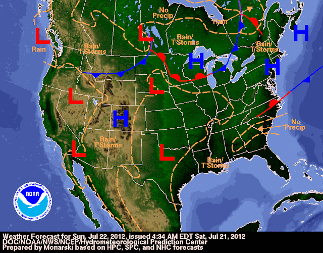
Warm Dry Weather To Continue with Thunderstorm Chances

Potential for Thunderstorms exist over The southern Portion of the province on Sunday as a Low pressure System Flattens the ridge

Precipitation will continue to be non existent over Southern Manitoba as the Warm Temperatures persist and the ridge in the jetstream holds it's place over the Province. Mainly sunny Skies daytime temperatures near 30C and nightime t
emperatures in the teens can be expected over the next 24 hours as a few low pressure systems travel through Northern Manitoba, leaving the rainy weather up there. Humidity levels will be lower and more comfortable today and through the rest of the weekend.

As for our precipitation not much can be expected in the region, although there will still be a couple chances but general amounts will be fairly low. The Chances look like they will be on Sunday as a low pressure system moves eastwards out of Saskatchewan through the Interlake Areas and parts of the Red River Valley. A Weather Moment Noted that "Models are suggesting that a band of nocturnal thunderstorms will push into Southern Manitoba on Saturday night and push eastwards before dying around mid-morning." After the storms clear out, nicer weather will be on the menu with sunny skies and beautiful temperatures near 30C.

Next Week Looks to Continue to Be Hot and Sunny with Thunderstorm Chances returning for the middle of the week into the second half of the week. Details on the thunderstorm potential remains unclear as this is still quite far off. I can tell you if a cold front or trough moves through the region with hot and/or humid weather and with extreme instabilty in place then there would be a risk of severe storms. All given that the cap (warm layer of air at the surface) is not too strong. If you are looking for severe weather chances I would bet on Thursday being the day, in Southern Manitoba as NOAA Weather Models Suggest a trough or front of some kind moving through.

Until then enjoy the Nice Weather, I will be away on Holidays and will not be able to update until the 27th of July or later. Follow my weather Links on the side bar of my blog for weather information while I'm away...

Wednesday, July 18, 2012

Even Hotter Weather On The Way

Most of  Southern Manitoba will become extremely hot for the second half of this week, with a slight chance for thunderstorm activity in some areas.
A Powerful upper level ridge will once again build in over our region
A powerful upper ridge will make it's way into Southern Manitoba over the next 12 hours. As a result heat will start cranking up in the southern half of the province and could last 3 days at the most. Tonight winds will shift to the south with most temperatures remaining in the high teens for overnight lows. The southerly wind will help clear the air of any leftover haze or smoke that has been hovering around. That will also aid more solar heating of the atmosphere resulting in cooking temperatures throughout the next 3 days. How hot exactly will it get? Models indicate temperatures of 37 to 40C over areas along the international border, while the temperatures further North towards Highway 1 along and South you can expect temperatures of 34 to 37C. Although I think that 40C might be a bit of a stretch on Thursday considering that it hasn't happened for a long time into history, as well as dewpoints sit in the 20's. With the temperature and the dewpoint combined humidex values will be from 40 to 45C across a widespread portion of the province, some places may even feel closer to 50C. It is near certain that we will see temperatures in the mid to high 30's with humidity values making it feel like the 40's It will definitely be a hot day in the southern half of the province. 

NOAA Wx Map at 00UTC Friday
Although there will be a potential for some thunderstorms on Thursday afternoon through until 6am Friday in Southern Manitoba as a front slides through, if storms fire along the front they may become severe given the heat and humidity. If nothing fires we will just see sunny skies, but then again there is a risk given the hot weather.


As for things on Friday daytime highs should be closer to 30C and not as hot as Thursday's 30C+ Temperatures. So thing's will feel a little more comfortable given less heat and humidity. As For the weekend hot weather to continue with isolated storm chances. 


Get Out There and Cool off with a Slurpee and or a Blizzard!

Wednesday, July 4, 2012

A Summary of Last Night's Storms; Warmer and Drier Weather On The Way

It was a crazy Night In Southern Manitoba last night, prompting Environment Canada to issue numerous watches and Warnings, Yet this is a view of what caused all of the trouble.
A view of the MCS Complex at it's most intense at around 13:00 UTC.
Some Regions Of Southern Manitoba saw a stormy start to the day as an MCS tracked over the region. The MCS formed around midnight last night in SW Manitoba after a scattered line of storms bunched together from Saskatchewan, it then got itself together and travelled through Southwest Manitoba and the Red River Valley. It Generated Intense Lightning and reports of winds in excess of 50km/h and rainfall rates of 125-250 mm/hr as it moved through. Just have a look at the rainfall totals from some of the locations that received heavy rainfall, especially in the Turtle Mountain region.

Boissevain.... 102 mm
Dunrea ....... 91 mm
Killarney .... 83 mm
Minto ........ 69 mm
Elgin ........ 69 mm

CPC Temperature Forecast for the next 7 to 14 days, the large area of red over Central Canada indicates there is a 70 to 80% chance of seeing above Normal Temperatures. That would be anywhere from 26 to 38C.
This was to be the last bout of rain for at least another 14 days, as another subtropical ridge of high pressure starts building northwards into the Canadian Prairies. This will push plenty of heat and some humidity into Southern Manitoba. Daytime high's could stay in the high 20's to mid 30's through much of the 14 day period, with the odd system bringing some light rainfall but nothing in high amounts. Hopefully this hot stretch will be short lived, we do not need another drought.

Anyways, enjoy the hot weather it is a part of the Summer Tradition.

Featured Post

Showers and Thunderstorms likely tonight

 Southern Manitoba will be likely getting severe weather this evening and overnight as another round of severe storms is possible, thanks to...