Hey everyone it's Mike here writing a brief update on a significant winter storm that is likely to impact will be impacting southern Manitoba this weekend I'm a bit late to the party as I'm just getting over a really bad cold it's going around apparently some other people I know have it. What what I've got from other people over the last six to 12 hours is that there is some pretty hefty amounts of snowfall forecast over southern Manitoba this weekend and this system will be moving into the southern sections of the province by the early morning hours so if you're looking for details this is your place for that. If you're interested I also have something to say about this on the weather comedy report however I had no idea that we were gonna be getting a winter storm models showing next to nothing for Southern Manitoba over this weekend and now we're about to get something really interesting.
Sunday: An area of low pressure will be moving into southern sections of the province during the morning hours ahead of the main stationary occluded front a large area of snow mixed with freezing rain will likely be impacting areas from the Saskatchewan Manitoba border all the way to the Portage La Prairie and Winkler regions. The heaviest snowfall starting at 6:00 AM in Western Manitoba and then 10am in the Red River valley areas. The thing is the heavy snow will likely be persisting in areas of Western Manitoba during the afternoon before tapering during the late afternoon whereas areas in the Red River valley will likely see snow persist well into the evening and possibly overnight time frame into Monday. I have some concerns that heavier snowfall bands visibility will be reduced to well below zero visibility if you have travel plans please consider leaving during the morning hours and not during the afternoon, also highways may likely be also closed. this system is gonna be feeding off some moisture from the Pacific as a Pacific flow will likely transition into a polar northerly flow behind this as cold air wraps in behind it.
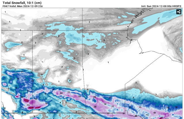
The good thing about this is that I do not have to write nearly as long of a write-up the previous storm system we had had multiple types of precipitation however I'm going to get to the snowfall totals right now. Areas in western Manitoba will bear the brunt of the system with a general 10 to 20 centimeters of snow possible of the areas in the Red River valley and points south including the Interlakes all the way to the American border can expect a general 10 to 15 centimeters or so with possibility of areas receiving more than fifteen centimeters by the end of tomorrow night. The snow will be a heavy wet snow during the afternoon hours and Justin had mentioned that it will be a dryer snowfall during the overnight time frame into Monday regardless this is the first accumulating significant snowfall for areas of the eastern half of Manitoba. I have attached some photos below of the forecast snowfall and the forecast storm.
Temperatures for tonight's Will drop into the low minus single digits tomorrow afternoon a majority of Southern Manitoba will be basking in mild temperatures between minus one and minus 2 degrees Celsius for most. Areas along the American border however will likely see temperatures a degree or two above freezing or around the zero degree mark.
The Week Ahead:. Temperatures will be on a declining mark with the majority of southern sections in Manitoba likely seeing temperatures dipping into the minus single digits to the low minus teens towards the beginning and middle of next week.


Sure appreciate the precise update. Thanks 🙏
ReplyDeleteinteresting and crossing fingers thank you
ReplyDeleteThank you Mike .Appreciate it.Glad you are feeling better.Just getting over that nasty cold as well.
ReplyDeleteAppreciate your precise report! 😊
ReplyDelete