Saturday, June 29, 2019

Severe Weather possible for southern Manitoba, this evening.

Much of southern Manitoba is at risk for severe weather late this afternoon into this evening.


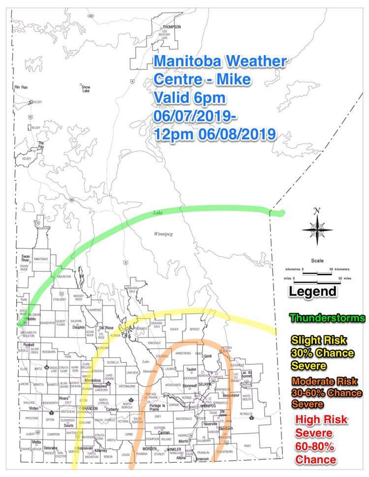
Southern Manitoba will be under the influence of a southerly flow today with temperatures reaching into the mid to high 20's with humidex values near and around 38 to 42C. An approaching trough and cold front to the west of our area will encounter the warm and humid airmass that is in place allowing a potential for powerful storms to occur. Let's have a look at the data.

Moisture: Dewpoints will be in the 18 to 21C range, for the most part with a chance for a few areas to have dewpoints about near 25C. Ample moisture will be in place. The question is the capping, because the moisture and heat may rise high enough in mid levels to prevent storms from forming. The cold front may or may not be sufficent to allow for enough cooling to occur at mid levels. And allow the cap to break.

Shear: Definitely not lacking at all, EHI values of 3 to 5 and Helicity mainly the highest west of Winnipeg into the Red River Valley around 8pmish 300 to 500 m2/s-2. Supercelluar structure is definitely possible, and or high winds. Sufficient enough for storm organization.

Instability: Sufficient instability will be in place for southern Manitoba this afternoon/evening, mlcapes and SBCapea will be on the order of 3,000 to near 5,000. With Lifted indices on the order of -7 to -10.

Trigger: The cold front will be coming in from southeastern Saskatchewan and moving into southwestern Manitoba over the next few hours into the Red River Valley area by the evening. Should provide focus for convective development as well as possible supercells.


The environment in place will end up resulting in severe thunderstorm/supercells formation somewhere between Brandon and the area east of Winnipeg, all depending on the timing of storms firing. If Storms do manage to form there will be a chance for discrete supercells to occur and pose a tornado threat. There is around 1 million or so people in that risk area for tornadic development, including Brandon and Winnipeg. There is a risk for hail up to golfball and or baseball size hail to occur, Once storms organize later on this evening the threat for damaging winds could be present with an ongoing large hail threat (up to baseball size hail), wind threat for winds over 100km/h, rainfall potential up to 50mm or more, and frequent dangerous lightning. Storm threat should ease up somewhat as storms travel into Northwest Ontario or southeastern Manitoba depending on where they form.

I will keep you updated as the evening goes on. -Mike

Friday, June 7, 2019

Severe Thunderstorms likely this evening into the overnight.

Good evening, everyone Mike here. Southern Manitoba looks like it may have one of the first severe weather events of the year this evening as we head into the overnight, a trough of low pressure this evening into the overnight will encounter a  hot and humid airmass in place this evening. This will allow for cooler and more stable conditions to come in play for the rest of the weekend.

A cold front crossing the province this evening into the overnight and morning, will be able to create the potential for severe thunderstorms. Looking at the data I have compiled there is sufficient ingredients available for severe weather to occur in our area, that could last well through the night. Let's use the MIST principle from A Weather Moment.

Moisture: A steady stream of gulf moisture will continue filling in to the area of the Red River Valley into Southeastern Manitoba with dewpoints (a good measure of what the humidity levels are like in the atmosphere, the closer the dew point is to the actual temperature the more likely it feels like a sauna in the summer under hot conditions. In the spring/fall it'll feel more like someone watered your lawn.) averaging between 15 to 20C, there will be no shortage of humidity which will allow the humidex values to peak to about 35 to 42C in areas.

Instability: With sufficient surface heating which occurred today and continues this evening, Instability in general is enough to fire severe thunderstorms. CAPEs will be on the order of 1,500 to 2,500 J/kg, less as the night goes on. Lifted indicies will also be between -2 and -8 at the max.

Shear: Bulk Shear of 20 to 50 knots and EHI values of 1 to 3 will be enough to support storm organization all based on current HRRR data and Data from the RDPS.

Trigger: Will be a cold front stalling out to the west of the Red River Valley and it moving east overnight, and an arrival of a frontal disturbance coming up from Montana and Wyoming overnight.

The photo I used above highlights the threat of severe weather for the area for the evening into tomorrow in Southern Manitoba. I only filled in the map with the lines, versus filling it in with colour so when looking at it your able to see better. In conclusion expect a line of discrete supercells or severe thunderstorms to form west of Winnipeg between 6 to 9pm and travel east northeast with additional storms likely heading into the late evening period. The main risks will be wind gusts over 1000km/h, hail up to the size of quarters, ping pong balls, or  golf balls, Heavy rain in excess of 50mm, frequent and dangerous lightning, and a very small risk of tornadoes. The risk of tornadoes is a 5 to 10% chance, low risk. U

The storms we get overnight will likely travel along the Red River Valley or a bit to the southeast of the valley depending on how things go with the setup. Justin and I will update you as things progress. The storms overnight might be a little less severe as heating from the day is diminished, the good news though is that we will get the needed moisture for this area of the province. A chance for thunderstorms redevelop tomorrow afternoon although non severe with a few sub severe cells possible.  A note a severe thunderstorm watch is in place for Winnipeg and the Red River Valley including parts of Westman. Full details here, for updates: https://weather.gc.ca/warnings/index_e.html?prov=mb

I look forward to tracking the storms with you all, this evening. Stay safe! Pray we get a good rain, God bless- Mike

Featured Post

Major Rainfall first of the season for Southern Manitoba.

Hello folks of southern Manitoba this is another weather update, we have some interesting weather on the way a low pressure system developin...