Friday, January 27, 2023

Extreme Cold Weather Arrives, Polar Vortex will likely influence our weather over the next few weeks.

 Hello Everyone Unfortunately, I have decided to take a hiatus on the blog (meaning weekly blog updates from now on) as not a lot of weather other than the extreme cold will be happening. Until the weather gets more active and if there is a change up in the pattern there probably won't be much in the way of weather updates. I'll still be sharing daily updates in the comments section, something that I havent done since 2014. 


Unfortunately it looks like a polar vortex will likely influence our weather over the next week heading into February. I'm seeing a very cold airmass sitting over much of the region. This same weather features sat over Russia and asia for the last few weeks. It doesn't look like any snowfall or significant weather will occur this weekend into next week. Temperatures will likely only sit in the low to mid minus 20's for day time high temperatures on Saturday this weekend with a likelihood of temperatures overnight into the low to mid minus 30's on the night Saturday. Theres a high chance that windchill values could drop even lower with a majority of the windchills this weekend. I'm seeing windchill values in the low to mid minus 30's during the day on Saturday and Saturday night likely even seeing the low's drop into the mid to high minus 30's. During Sunday similar values in the low -30's are expected.


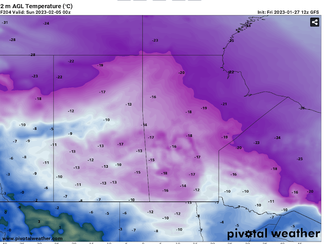
There is a concern that the windchill values on Sunday night could exceed minus 40C and that will be a high risk for areas of southwestern Manitoba. (Above). 


That photo above is the polar vortex sitting right over southern Manitoba on Friday next week, that will likely end up being the coldest period of weather this year so far. Sunny skies and partly cloudy skies are likely during this period. Heading into the week and next week I see a concern for this cold persisting well into the end of the week. The only breif reprieve I see is during the day on Monday when a clipper will likely pass through the region, with our daytime high values rising into the high minus teens with windchill values in the low minus 30's. The cold weather returns next week with a vengeance, overall daytime high temperatures will fluctuate between the high minus 20's and high minus teens.


(Left): Overnight low's will likely persist in the low minus 30's to the high minus 30's with windchills at a risk of dropping well into the minus 40's. Wednesday looks like it will end up being the coldest period of weather during the morning where windchills could exceed minus 40C. 


(Above): There is a glimmer of hope however, a break in this cold weather is possible by next weekend. I see temperatures returning to the high minus teens, you can thank the return of some low pressure systems drawing in some warmer pacific air. How long this pattern will last is uncertain. In the mean time stay warm, maybe even sip on some hot chocolate. 

Wednesday, January 18, 2023

Mild Weather Continues for the foreseeable future.

 Much of our region has experienced a very warm January so far with periods of thick fog patches,  freezing rain, freezing drizzle and cloudy skies. A few weeks ago I even noticed it was misty outside. That is something you don’t see in January. Regardless you can thank this to the colder than average weather with the polar vortex impacting Russia and Siberia. Read onto find out when this pattern could change below…. 

Manitoba and Canada with the warmth across the North American Continent….


Below a photo of the polar vortex enveloping Russia and Siberia currently showing temperatures in the -40 to -50C range… That is cold!!! 


We won’t be seeing this polar vortex move locations for a period of time, thankfully. 

As for our weather this trend of warmer weather looks to continue thanks to the presence of a westerly to southerly flow aloft as high pressure sits to the north of us keeps us in a mild flow. Let’s have a look at the details… 

Rest of today: Temperatures over the next 12 hours will be mild, there will be a chance for freezing drizzle or light flurries this early evening moving up the red river valley into the inter lake regions. Cloudy skies will persist.  By this evening temperatures will range from the high minus single digits in the southeast to the low minus teens in the southwest hovering around the -8 to -12C mark. 

Tonight: Flurries and or freezing drizzle will persist in the overnight period into the morning hours mostly in the south central and southeast regions spreading all across the south by the overnight period . Temperatures will drop into the mid to high minus teens overnight . 

Thursday: Daytime high temperatures will rise into the low to mid minus single digits. Mostly cloudy skies are expected with the chance of fog patches developing later in the day. Still a continued chance at flurries and or freezing drizzle across the region. 

Thursday Night: Overnight low temperatures will drop into the low minus teens and high minus single digits. Cloudy skies will persist for those in the southeast; however clearer skies are likely in the southwest. 

Friday: Temperatures will rise into the low to mid minus single digits with areas still seeing unseasonably warm air some areas may be close to the freezing mark!! Break out your shorts . The cloudy skies will likely persist until the afternoon hours with a chance at clearing skies by the mid to late afternoon hours from west to east.  

Friday Night: Some of the mildest air will stick around with lows only sitting in the mid to high minus single digits a chance at colder values however are possible. A batch of snow showers are likely to move into the western portions of Manitoba overnight into Saturday morning. 

The Weekend: Saturday looks mild with daytime high temperatures remaining in the low to high minus single digits, snow showers are possible on Saturday before clearing on Sunday early morning. The cold weather arrives again on Saturday night as a trough moves through. Overnight lows on Saturday night could approach -20C but will sit in the mid to high minus teens windchills will likely be colder in the minus 20C to -25C range. Sunday the mild weather returns with slightly colder values in the high minus single digits and low minus teens. The same values expected to drop into the low to mid minus teens. 

Friday, January 6, 2023

Mild weather to Start 2023, Where did winter go ???

Hello and Happy New Year Everyone!!! 2023 is likely going to be an interesting year ahead weatherwise, with Manitoba you never know what your going to expect. As we look at the weather this weekend I’ll make this post short and sweet. 


Temperatures above for the day on Sunday. Warm and mild. I like it . 😯😊

Saturday: A warm front will be moving into southern sections of Manitoba and across the region from the start to the latter half of the day. Temperatures will be given a boost, with our values from the mid to high minus teens in the morning warming well into the high to mid minus single digits by the afternoon hours. 

Saturday Night: This warm and mild trend looks like it will continue into the overnight on the night Saturday into Sunday. Temperatures will drop only a few degrees below -10C, with a lot of the warm air centred from the northern parklands, inter lakes and nopiming park eastern regions.  I don’t see any signs of precipitation falling until at least mid week. However increasing clouds then cloudy skies will be in place likely over the area Saturday evening persisting well into the weekend  which will help us remain mild. 

Sunday: Temperatures on the day Sunday will likely rise into the mid to high minus single digits so the -4C to -9C range. Sunday night will feature cloudy skies and fog patches are also possible. 

Sunday Night: Temperatures on the night Sunday into Monday will continue basically just sitting in the values they were in all weekend. I’m only seeing the colder values in the central parts of Manitoba with lows there from -10 to -12C. 

The Week Ahead: Southern sections of Manitoba will continue to experience warm weather for the week, with highs in the low to mid to high minus single digits. However warm weather may end during the second half of the week during the overnight periods with lows reaching the low to mid minus teens. We will watch for any changes to this pattern . In the long range. 

The warming trend will likely stick around for next week this is all thanks to what we call ridging, and this is very unusual in the winter season during a La Niña pattern. 

Featured Post

Major Rainfall first of the season for Southern Manitoba.

Hello folks of southern Manitoba this is another weather update, we have some interesting weather on the way a low pressure system developin...