
Tuesday, April 28, 2015
Monday, April 6, 2015
Thursday, March 26, 2015
Spring Pattern Setting Up
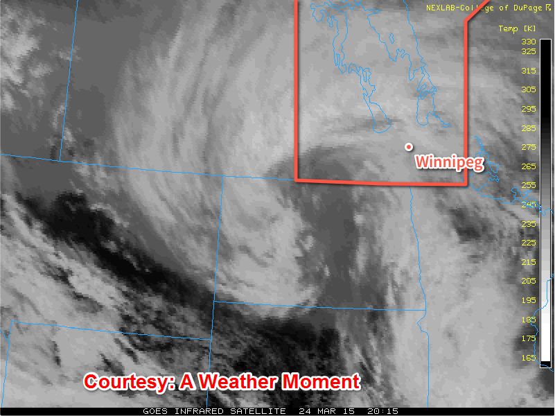
After a period of very warm weather that melted all of our snow last weekend in through the week , the snow came back with a vengence giving southern Manitoba another taste of Winter despite there being rainfa
ll with the system. During the day on Tuesday through Wednesday, the seasons first most potent storm system came through Southern areas giving regions impressive snowfall totals some areas racking up as much as 25cm. This appears to be the last significant snowfall of the season here in Manitoba, let's hope. (Totals shown below).

The snowfall and gusts of 60-70 km/h making visibilities low and highways very slippery, it was quite bad for motorists who were travelling along highway 75, 59 and Highway 1, 6, 16 and 10. 2 Accidents ocurred, one about 5km east of Elie with 2 semi trailers that collided in a jackknife collison. Also along highway 75 a schoolbus rollover occured by Ste Agathe. There were also several other rollovers that occurred which resulted in highway closures. http://winnipeg.ctvnews.ca/treacherous-road-conditions-lead-to-multiple-manitoba-crashes-1.2296304
There were also power outages in parts of Winnipeg, on Inkster and out in the Dugald areas. Southern Manitoba for the most part had numerous power outages caused by heavy snow and wind (which caused power poles to ignite). Manitoba Hydro is working on a fix for towns affected. On top of the snow that we recieved we also picked up about 8mm of rain here in the Winnipeg area. So what will our weather look like for the next few days? Let's have a look below.
The day on thursday will be a fairly cool day with the wind blowing from the Northwest fairly light, although given the strong March sun it may not feel all that bad outside. There probably will be a significant amount of melting given the below zero temperatures that are forecast for the day so it will probably feel nice outside. We cool down a couple degrees past the minus ten mark, overnight. May not all be that bad.
Mix of Sun and Cloud
-3C / -13C
Friday:

Friday will be a sunny day to start off in the red river valley, until a system slides through our region as flurries move out of southwestern Manitoba. Amounts of 1 to 2cm can be expected in the Winnipeg area. There will be a likely chance they will exit the region by around mid afternoon, any snow that falls will likely melt. High's will still be about 2 or 3 degrees below average in the Winnipeg area.
Flurries then Sunny
-2C/-12
Saturday Through Monday
Is it is looking like another storm system will be on our doorstep for the day on Saturday and Sunday. It is still quite far out to say anything yet, although given our model trends with past storm events it's quite likely this will turn out to be a event worth talking about.

However latest model runs are showing that it will be warm enough to support a rain event. That will likely be the case considering we are nearing the month of April, the rainy month. So it may be a cloudy and wet weekend with temperatures sitting above zero for the most part. It has been a dissapointment that our weather has not been dry and mild, however as we get further into Spring our weather will certainly get nicer. So with the look of things we are starting to enter a more typical stormy spring pattern, and hopes are that the weather will get a lot better and not stay gloomy and wet althrough the spring. We aren't in Vancouver after all. :-)
Monday, February 16, 2015
New Website
There is a new website up and online at www.michaelmcgregor7.wix.com/southmbweather, I have added a bunch of new features I was unable to provide here on blogger. They include interactive radar, animated satellite imagery, weather models and weather alerts. If you have any ideas for the new blog please, send me a message on Twitter or email me at michaelmcgregor7@gmail.com. Thank you. Sincerely Michael McGregor.
Sunday, February 1, 2015
Thursday, January 22, 2015
Coming Later Today: What Will Happen When A Tornado Hits Winnipeg?
It's only a matter of time before the big one hits, as the city of Winnipeg expands and becomes a larger target.
Tuesday, January 20, 2015
What Will Happen When A Tornado Hits Winnipeg?
 As you know Winnipeg is a very structured and unique city, that we live in. So many good qualities and cultures thrive here. Although given our geographic location it puts us on the northern fringe of tornado alley, with on average of 13 tornadoes a year in the province. We barely get as much as what the Plain States receives, they pick up as much as 1,000 tornadoes a year, however our summer severe weather can be just as bad as what happens in the plains, under the right conditions. In past history we have had tornadoes strike several towns including Portage La Prairie, Altona, Brandon, St.Adolphe, St.Claude, Brunkild, Pipestone, Turtle Mountain and Elie. Don't forget Winnipeg has had 9 confirmed tornadoes since records began in 1872. I will talk about the Portage La Prairie and Elie Tornado because they are the most memorable events in Manitoba's history. With a interesting scenario on Winnipeg's next tornado. With information from Brock Holowachuk, Impact a history of disasters in Manitoba.
On the night of June 23,1922 a strong progressive derecho thunderstorm line marched across the provinces of Saskatchewan and Manitoba producing damage and several tornadoes that caused damage to several towns and communities. The first report was around midnight in Bradenbury Saskatchewan, it swung southeast through Regina before it headed east for Manitoba. It struck Virden and Brandon at 12:40am, but the greatest of its energy didn't start building up until just west of Portage La Prairie (within the MacGregor area). The 10,000 residents of Portage La Prairie awoke at 2am to a distant roar with the sky to the west bright with lightning. Five minutes later hail pelted roofs with the force of axe blows and windows, walls, and roofs were destroyed. Trees and telephone poles were pulled out of the ground or snapped into pieces, making streets impossible to drive through. Automobiles were picked up and thrown about in the streets, the Kloss family home was lifted cleanly from its foundation and moved 25 yards away with the family and 2 guests inside. The family was ok but the guests were knocked unconscious. After 30 minutes the most severe part of storm passed through town and moved east likely losing tornadic capabilities, although strong winds continued for two hours. Daylight revealed that not a single house in the community had been spared, some homes were completely levelled. Streets were littered with debris and the main business strip was in ruins. Crops were badly damaged outside of town. In one case the Merchants hotel was torn off the building and carried one block east before it settled in front of the post office. One hundred percent of crops were damaged just east in Elm Creek and Carman, alongside more destroyed homes. The storm arrived in Winnipeg at 3:30am even in the darkness it was clear the storm had fury with winds in excess of 135km/h the same strength as in Portage La Prairie, though not tornadic. It still had fury as wind, rain and hail tore apart the city. The most severe damage in Winnipeg was around Logan Avenue, Minto Street, Mcphillips Street, and Notre Dame Avenue. Also the roof at Sapton Creek Church in Hazelridge was lifted one hundred feet away, forty percent of crops in the Tyndall area were lost. The storm weakened as it moved east toward lake Winnipeg, where hail was the size of pennies, compared to the hen egg sized hail in Winnipeg. Power was out for most of the city for a few days, and work crews were sent to Portage La Prairie to help repair the damage. All in all severe weather is a huge occurrence in summer, though this is a sharp contrast to what happened in Elie on June 22,2007.
On the day of June 22,2007 I remember it being hot, humid, sticky and very tropical like. I was in Grade 6 at the time, just starting Middle School. I came home at the end of the day and came to watching the news and The Weather network on tornado watches province that were happening, I also remember watching live updates from John Sauder on CBC. Turns out a tornado was happening I never got to see the tornado, but I did know something big was going on that day by the way the weather appeared here in Winnipeg.
 |
| Elie Tornado Track |
 A frontal boundary was in place the whole day The atmosphere was primed the whole day for severe weather it just couldn't develop because there was a cap in place (a warm layer of air at the middle levels of the atmosphere) that inhibited storm development. The frontal boundary that was in place the whole day in the interlakes finally had enough lift in the atmosphere to overcome the cap, when it did a thunderstorm cell developed just west of Winnipeg along the trans Canada highway. As it tapped into the low level inflow it became a super cell and produced its first tornado, the super cell sat over the same area for quite a long time, forming in the field right next to the trans Canada. It then travelled southeast and hit the flour mill looped around it once and towards town before looping back north hitting four homes and lifting one completely off its foundation before exploding next to the flour mill. A few moments later the tornado picked up a Chrysler fifth avenue and dropped it a hundred feet away. It decided to loop southwest before it died off. The tornado, In a quite a popular area too, right along the trans Canada. The amount of storm chasers was quite outstanding. Justin Hobson's Story on the event can be found here.
Things would have been much worse if this tornado travelled into Winnipeg, or worse if the storm had of initiated 45km west and became tornadic as it did in Elie. Winnipeg is due for another tornado, this time it might be as bad as Edmonton's July 31,1987 tornado. I'm going to debunk the myth that tornadoes cant hit cities they can its just that cities are hit less often given there smaller land mass, compared to the areas of farmland.https://ca.answers.yahoo.com/question/index?qid=20060810205824AAcQ68v It's only a matter of time before a tornado strikes Winnipeg given our situation with severe summer weather events, Im saying it as a fact since we live in the middle of tornado alley. So what will happen?
First we will need these ingredients:
M- Moisture ( Humidex as high as 30C needed, ideally 40C or more)
I-Instability (CAPE of 3,000 J/Kg or more, no capping.)
S-Shear ( enough shear to produce and maintain tornadoes)
T- Trigger we need some kind of frontal feature cold front, warm front, trough, lake breeze to create lift in order for storms to develop. The most likely feature to set off a tornado would be any frontal boundary.


Please Share your thoughts and opinions below, I would really enjoy some feedback. Maybe I'll even join in!
Saturday, January 17, 2015
The Yellowstone SuperVolcano Has Come Back To Life, Eruption Soon?
Yellowstone National Park is home to one of the most beautiful places on earth, with vast hills and valleys, magnificent rock formations and hydrothermal features including the well known old faithful. Also is home to plenty wildlife, but not a lot remain there at the moment. It is also home to one of the largest supervolcanoes on the earth, that could have the potential to affect the world if it erupted. The volcano features a magma chamber that is 14km deep and 88km across, larger than previously thought by scientists.
 |
| Yellowstone Caldera Size |
If it erupted it would be 2,000 times the force of Mount Saint Helens (10,000 atomic bombs) kill everything within a 100km radius instantly. Everything beyond that point would be covered in ash from as much as 5 to >1,000mm. Oh it gets better, it would be enough to destroy or make half of the continental USA and parts of southern Canada including Calgary and Regina uninhabitable. The effects would be felt for a long period of time, thousands of cubic kilometers of ash would block out the sunlight for years and create a volcanic winter making global temperatures plummet as much as 2 or 3 degrees.

What is more concerning though is that the volcano has been showing many signs that it is active and is going into high gear. Earthquake swarms have been taking place since 2009, and have been steadily increasing in intensity and frequency. The number of earthquakes that have been recorded and the amount of energy seismically has been very unusual and worrying to the USGS. Over 2,000+ earthquakes were recorded inbetween 01-17-2010 and 02-03-2010 in Month/Date/Year Format. The figures are alarming!
On top that the mainstream news is no longer reporting events on Yellowstone given a gag order from Barack Obama administration from back in 2009. I even messaged Jillian Taylor of CBC to see if she would be interested in doing a story on Yellowstone, she never responded. USGS has been downgrading and covering up earthquakes to minimize the public's panic. They obviously have something to hide, otherwise they wouldn't be doing it in the first place! If you don't believe me they are lying, to cover up check out Mary Greeleys Channel For Proof.
1/14 Yellowstone Super Volcano Report USGS Hides Lies On Charts Nothing To See Move Along. Hiding Something.
If that doesn't concern you, some graphs are being cut off to hide data on the real earthquake threat and occurrences. They have been doing this for months and continue to do the same to make it look like nothing is happening at all. There is something going on, and the lady Mary Greely has proven it in the video above. They don't want the public to know how bad it is, earthquake swarms are at the highest they have been. Why would they want to erase such data anyway? Harmonic tremors might be why they are deleting data, to prevent the public from noticing. Animals have been staying away from the park, and this website will tell you the truth.... Yellowstone Moose Creek Reports.
 |
| Earthquake data being cut off, for some unexplained reasons. |
Alongside the increased earthquake activity and swarms geysers are erupting that were once extinct in the park. The famous steamboat geyser and a bunch of other mini geysers are erupting. Not one dormant geyser is to be seen, interestingly enough this proves that the geyser basin has become more active in the past years. Pretty soon a whole bunch more will start appearing at this rate. Does that tell you that Yellowstone is getting ready to blow? To me its a sign. It doesn't mean an eruption is imminent but it is showing signs that the basins hydrothermal features are becoming more active,, just like volcanoes when they start spewing steam.
Also yesterday a really concerning situation took place in Yellowstone, the old faithful geyser instead of erupting out in white it came out in black. What does that mean? That means that magma is getting close enough to the surface to start affecting the geysers in causing rocks and materials to burn. That's not a good sign! Never has old faithful come out black before, that significant. Magma has been uplifting and intruding closer to the surface allowing for such an event to take place, if this turns black and stays like that we are in trouble. Odds are that might happen. I am truly concerned that this is a precursor to an eruption, we'll see. Although this may not happen at all. Here is the video.
Mary Greely News: Old Faithful Turned Black
In addition to the geysers erupting another concerning development is the fact that scientists have confirmed that volcano is releasing helium 4 a ancient gas that previous volcanoes have expelled before an eruption, a few underwater volcanoes have done the same before they erupted. There were measurements stating that other elements were being released such as sulfur dioxide CH2. These elements are only released if the volcano is forcing magma closer to the surface then in turn pushing the ancient gasses up with it. This is also one of the many signs of an impending eruption. These Videos describe first hand how bad this is. This is not a good sign!
Reports also include magma rising and getting closer to the surface, also most of the snow melting because of the heat from the volcano below the ground not from sunlight or sidewalks, or air temperatures. That is another indication that something is amiss, the land has been rising at an alarming rate. Roads have been melting, links taken down on stories regarding Yellowstone. Someone also reported according to the bunker report, that they saw a fox get swallowed up by the ground and some orange glow coming from the geysers at night. A report summary is available Including some bulges in some places in the park, there is evidence all over youtube.com. I can honestly say, watch the video below at your own risk.It will change your mind about Yellowstone, in a flash. . A report summary is available here..... http://www.mythi.com.br/moose_creek/moose_creek_body.html
Reports also include magma rising and getting closer to the surface, also most of the snow melting because of the heat from the volcano below the ground not from sunlight or sidewalks, or air temperatures. That is another indication that something is amiss, the land has been rising at an alarming rate. Roads have been melting, links taken down on stories regarding Yellowstone. Someone also reported according to the bunker report, that they saw a fox get swallowed up by the ground and some orange glow coming from the geysers at night. A report summary is available Including some bulges in some places in the park, there is evidence all over youtube.com. I can honestly say, watch the video below at your own risk.It will change your mind about Yellowstone, in a flash. . A report summary is available here..... http://www.mythi.com.br/moose_creek/moose_creek_body.html
More reports will keep coming in from the park I'm sure. I'm definitely keeping my eye on it! So what are the signs of a volcanic eruption?

- Increased Seismic Activity- Check
- Increased amount of gas from the caldera. - Check
- Increase amount of Sulfuric Acid. - Check
- Change in land characteristics (land mass bulging). -Check
- Sudden increase of Geyser activity around the volcano. -Check
- Change in the Geothermal characteristics surrounding the volcano (hot springs & etc) - Check
In Conclusion whether I believe it or not, Yellowstone is long over due for an eruption. Please pray for family that lives in that area and tell them to be wary of the possibility it could erupt. I am going to keep a close eye on any further developments that take place at Yellowstone. Please take care, and be prepared for a disaster!
Update!!!!!!! January 20,2015
All Yellowstone geysers turn black or grey to white. Old faithful erupts longer than usual....
Update!!!!!!! January 20,2015
All Yellowstone geysers turn black or grey to white. Old faithful erupts longer than usual....
Tuesday, January 13, 2015
My windows 8.1 OS, a storm chasers dream come true!
After years of running on the operating system of windows 7, I have decided to upgrade to Windows 8.1. I am unfortunately one of the few people to upgrade to windows 8.1, given most have decided to stay away because of the awkward start screen and metro interface that was meant for tablets only. The fact that there is a clumsy navigation between the desktop and metro interface, bugs others. It doesn't bother me at all. The first feature that I absolutely love about Windows 8.1 is that you can add
There also is a ton of customization features that you can try out on your start screen, I have made mine into a weather centre using all of the best weather apps out there. It is going to be perfect for when our severe weather season arrives. The only thing about the windows store is that there are not a lot of weather apps to run from the Windows Store. I hope that will change in the future, with the integration of windows 10. I myself might create an app to send to the app store for SouthMBWeather would you like that?
Alongside WeatherBug is the next best weatherapp to use, storm chasers would love the features of this OS! Even though there is not a lot of Canadian features such as Enviroment Canada Radar with this. It still notifies you to weather outlooks like it will storm today, foggy today along with a bunch of others. It still might be of good use for my American Storm chasers. If there is anyone that views my site from the states. The forecasts from Weather Bug are ok I guess, but lacking the features for Canadian regions.
Overall I'm rating windows 8.1 a 4/5 ****/***** for weather features and productivity. I am hands down fine with the transition between desktop and start screen. As long as I can get things done without issue. If anybody has complaints about why it is such a bad operating system, please don't bother wasting your time with it there if you haven't even tried it out yet. Your mind will change once you give it a try. If you feel like you want to keep Windows 7, go ahead! I'm just saying that the support from them has ended with the release of Windows 10 in summer.
Another post is on the way tomorrow about some concerns going on about the Yellowstone supervolcano, and severe summer weather concerns for our future ahead.
a start is back feature to allow for a start menu on your desktop. There is also a feature called Areo Glass for Windows 8.1 that you can install on your computer if you want to.
 |
| Windows 8.1 Desktop With StartIsBack |
 |
| Windows 8.1 Start Screen |
Also the Accuweather App is by far the best and will be for storm tracking, the ultimate weather app in windows 8.1! Featuring a Minute cast and monthly weather outlook. Live Tile for Weather Conditions and the outlook ahead. Wonder how I'm gonna feel running a top notch weather centre at the time summer rolls around. Trust me you'll want this, it's better than that of Windows 7 and Accuweather radar online. It's full screen!
 |
| Accuweather For Windows 8.1 |
 |
| WeatherBug Notifications |
 |
| WeatherBug for Windows 8.1 |
Overall I'm rating windows 8.1 a 4/5 ****/***** for weather features and productivity. I am hands down fine with the transition between desktop and start screen. As long as I can get things done without issue. If anybody has complaints about why it is such a bad operating system, please don't bother wasting your time with it there if you haven't even tried it out yet. Your mind will change once you give it a try. If you feel like you want to keep Windows 7, go ahead! I'm just saying that the support from them has ended with the release of Windows 10 in summer.
Another post is on the way tomorrow about some concerns going on about the Yellowstone supervolcano, and severe summer weather concerns for our future ahead.
Subscribe to:
Posts (Atom)
Featured Post
Active weekend on the way to Manitoba
Well another weekend of active weather is set to impact southern Manitoba this weekend, thanks to a large trough setting up over western Can...

-
 Hello folks I am back after not being able to write blogs over the last few months. It has been an interesting summer with sleeper setups, ...
 -
 A strong and potent low pressure system will be impacting southern and central Manitoba before another cooldown impacts our region, another...
 -
 Hi everyone, Mike McGregor here. I am here to provide another weather update with details on the next system expected to impact southern an...