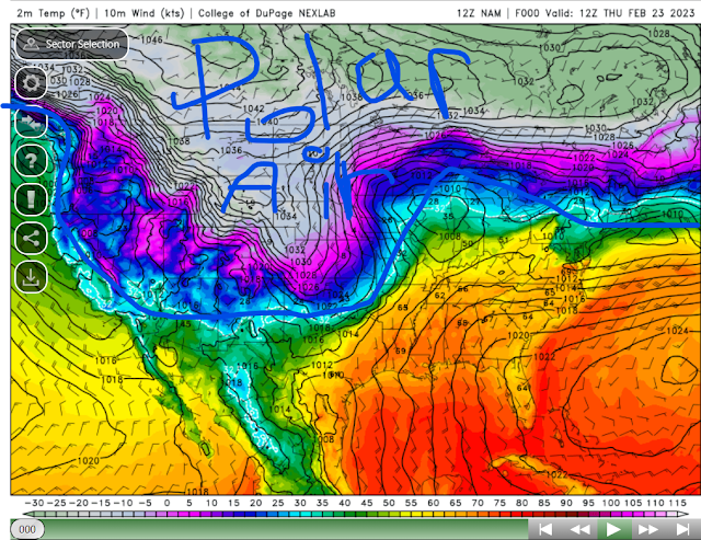
Much of Southern Manitoba and sections of central Manitoba, have been under the influence of extreme cold thanks to a persistent polar vortex sitting over the Canadian prairies. This airmass will likely depart our area over the next few days. I unfortunately had a really bad cold for the past few days, on top of a stomach bug so I wasn't able to post on the extreme cold that was headed for us. It appears this unbearable cold weather trend will likely end sometime later this week. (Below: Photo of the Polar Vortex and extreme cold airmass sitting over much of western Canada. It was cold enough for snow in the Las Vegas Mountain regions this past week I'm not kidding.)
Heading into the second half of the week, not much in the way of weather is likely. There isn't any significant low pressure systems likely heading into the weekend. For the rest of the day today remnants of a low pressure system will drift in with increasing cloud cover and a bit more bearable temperatures with high temperatures today reaching the minus high teens, and low -20's. Windchills will likely be a bit colder with values in the high minus 20's to low minus 30's the coldest of this air will likely be in the Pembina valley into the red river valley.
Thursday overnight into the morning Friday will likely be cold but with values not nearly as bad during the week, overnight temperatures will drop into the low minus 20's with windchills in the high minus 20's to the low minus 30's. Word of advice for those in the Pembina valley and red river southern regions is where the coldest of that air will exist. Clearing skies are also likely heading into the overnight period.
Friday will end up being a very different day, temperatures will rise into the mid to high minus teens -14C to -18C and overall windchills will be well below minus 30C, in general anywhere from -20C to -26C. Under mostly sunny skies before increasing clouds come in during the late evening.
Friday Night: A batch of cloudcover will likely move into the region with a small disturbance moving through ahead of a warm front, a general trace to 5cm can be expected as this system moves through. Unfortunately our snow drought continues. However after that clears our temperatures will likely take a plunge with our overnight lows dropping into the low minus 20's in western Manitoba, and some central regions. Areas further east will see lows in the high minus teens. In general (-18C to -25C) with overall windchills well into the mid to high minus 20's.
The Weekend: "End Of The Cold Streak":
Much of what happened this week is likely due to the influences of a fading La Nina and a polar vortex which did sit over our area for a significant length of time. Temperatures will rebound on the day on Saturday with high temperature values in the low to mid minus teens, (-10 to -14C). There will likely be an area of flurries off in eastern Manitoba during the day. Overnight into Sunday morning low temperatures will drop off again into the mid to high minus teens, with windchills in the mid to high minus 20's. Sunday will end up being the mildest weather we have seen since at least the beginning of the month, with our average day time highs soaring into the low to mid minus single digits some areas may even see highs above zero in the extreme southeast. Increasing clouds are also likely during the latter half of the day. The same goes for Sunday night where our lows will drop into the mid to high minus single digits.
The Long Range: As we transition into ENSO Neutral which means theres neither cold nor hot water off the coast of the pacific in south america will allow for less cold snaps, to develop over our area (Below). The only thing I see next week is a low pressure system on the day Monday along a westerly flow that might bring snow. Fluctuating between the low to mid minus single digits to the low minus teens for day time highs with and the lows dropping from the minus teens to low minus twenties on rarer occasions. Warmer values likely during the first half of the week, with fluctuating values towards the latter half of the week.


