Showing posts with label Storm. Show all posts

Wednesday, June 6, 2012

Our Hot Week Set to End with a Bang!

(Information Provided by Brad from A Weather Moment)

Temperatures are ready to soar for the rest of the week as a heat source from the Gulf of Mexico builds into the southern portion of the province. Everyone across all of Southern Manitoba should begin to prepare for a potentially dangerous end of week powerful low pressure system that will threaten the first significant severe weather outbreak of the season.

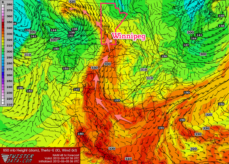
850mb theta-e (a form of measuring temperature) chart valid for 06Z Thursday 07 June


The above picture with the red arrows very well depicts the advection of a warm Gulf of Mexico airmass into our region, (theta-e is basically a form of measuring temperature). A southerly flow aloft, aided by a long wave trough over British Columbia to our west and a blocking high to our East will bring us the hottest days we have experienced this year, throughout the rest of this week. Temperatures are expected to reach the 25C to 30C range through the second half of this week.       
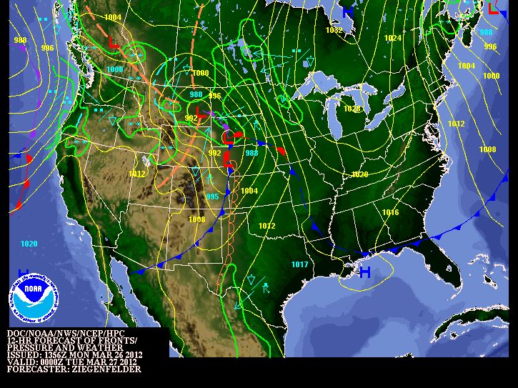
Postion of fronts and weather at 00Z Friday
 A weak low pressure system will move through Southern Manitoba throughout Thursday night, ahead of the main upper level feature. Even though dynamics don't look to great for severe weather, a line of thunderstorms will likely develop during the late afternoon and evening hours they will intensify aqnd slowly move east-northeastwards. While tornadoes will not be likely with the storms on Thursday afternoon/evening, CAPE values near 1250 to 1750 J/kg combined with Lifted Indicies near -5 and 20 to 30 Shear should be enough for large hail according to Brad. The possible slow moving nature of the line of storms could produce a risk for heavy rainfall with as much as 30+mm falling over a short period of time. While showers will be common over the southwest portion of the province on Thursday, the chance for showers does extend eastwards through the Red River Valley in the afternoon. Most of the precipitation will fall with the thunderstorms that will develop in the evening.

Although this is still 36 hours away and things could change a lot between now and then. According to Brad "models still are having a hard degrading the blocking pattern that is in place right now ,and some are much more progressive with features and some are much slower."  If things end up more progressive than the look now, there may be a small storm threat for Thursday night.


Thunderstorm Outlook for Night 2 (00Z to 18Z June 08).
Brad says " That taking into account the various speeds, the current area that might see storms on Thursday afternoon/evening looks to be the area bounded from the US border north to Brandon, up towards Dauphin/Swan River, then eastwards across the Interlake and southwards down the eastern Red River Valley. Storms will exit through the Central/Northern Whiteshell. Friday will yet again be another warm day;debris cloud left behind from Thursday Night's convection should clear around lunch time which will hopefully allow the sunshine to warm us to the mid to high 20's. Dewpoints look to build in the afternoon pushing up to the 18C or 19C degrees making it feel quite humid. The main frontal system is set to move in on the weekend, and what a system it looks to be.

SPC Day 4-8 Severe Thunderstorm Outlook


According to Brad "We’ll be under the influence of two strong shortwaves that will push copious amounts of instability over Southern Manitoba. CAPE values look to exceed 2500 J/kg and potentially be as high as 5000-5500 J/kg; this, combined with a weak cap north of the warm front and favorable shear profiles looks to point at a potent setup for severe thunderstorms with high probabilities of (extremely) large hail, strong winds, and elevated risks of tornadoes." From My perspective it looks like this setup will be similar to June 22nd and 23rd 2007 tornado event that featured Canada's first F5 Tornado in Elie and that also resulted in 6 other dangerous tornadoes in Southwestern Manitoba.

More Details will be available throughout the next couple days on Twitter and some on my blog post on this potentially serious Storm Outbreak.

Friday, May 25, 2012

Cool Stormy Weather on The Way For the Weekend

Manitoban's get ready for a wakeup call, the next few days are going to be ridiculously cold with daytime highs over 10°C below the normal and overnight lows over 5°C below the normal. The sun will make only a couple appearances over the next few days as another forecasted storm system pushes into Southern Manitoba, bringing another round of rain and a few possible strong thunderstorms to the Red River Valley, especially near the border.
The 850 MB Temps forecasted by the GFSX Model for tonight at 00Z ( 7pm), as temps will cool with the passage of a trough.

This downright cool weather has brought late-season snow to several communities in Western Manitoba including The Pas, Flin Flon and higher elevations over SW Manitoba. Areas that received snow in higher elevations were Swan River, Duck Mountain, Porcupine Provincial Forest and Riding Mountain. (Even Rob wrote out an article on the snowfall event, read up on his perspective here) Just be glad we never experienced any snow in our region.

Tonight, there is a high threat potential for frost in most of Southern Manitoba, as we see the arrival of another surface ridge and clearing skies. Areas most at risk for frost tonight appears to be in all of the southwestern portion of the province into the park lands, east into the RRV especially areas north of the transcanada highway. The threat also extends east through Winnipeg towards the Ontario border. Areas not included in the risk for frost are along the American Border. There currently is a frost warning in place for almost the whole southern section of the province view the map here.

 Tomorrow will be a transitioning day with temperatures reaching the 12 to 17C range in all of the south, with cloud streaming northwards from the Dakota's with the next system. Rain will push up towards the American Border by morning, likely staying south of the border all day tomorrow. The rain will stay south of the border until the big northward push comes on Sunday.

Showers and Storms will be likely throughout the day on Sunday in Southern Manitoba, as the system pushes North. As shown by the NWS Weather Maps.
Potential for more showers on Monday


And quite the push it will be! Rain and Isolated Thunderstorms will be going on throughout Saturday night south of the border, although the storms will likely weaken by sunrise and the rain will slowly push northwards across the Red River Valley. Most regions across Southern Manitoba should expect the showers to start fairly early on Sunday and last throughout the day, with the possibility for the formation of non-severe storms especially in the RRV during the late afternoon,evening. The rain and possible storms will taper off west to east overnight and will clear out. With another potential for showers Monday as this significant weekend system brings wraparound showers, while it leaves our province. Overall rainfall amounts in Southern Manitoba can be expected to be in between 5 and 10mm in showers,(at least 30+mm) amounts in storms. And inbetween 20 and 30 mm in western manitoba where you will be closer to the heavier rain.This really isn't the best of news for this year's teddy bear picnic, but hopefully it won't dampen their fun and spirits. 

This likely will be the last cold blast of the season, before we start experiencing some warmer May like weather, and some hot June temperatures. That is a long ways away from now, so let's have a look at the improving weather after this rainfall....  Conditions do look like they will improve through the middle of next week, with temperatures pushing back towards the 20C degree mark and some sunny conditions making an appearance. In the mean time put on some PJ's or slippers and kick back and relax as this weekend will be a stay at home weekend. Except for the storm chasers out there who may want to storm chase on Sunday here or in North Dakota if conditions follow through.

Friday, May 18, 2012

More Showers and Thunderstorms on the way for Parts of southern Manitoba

While temperatures will soar to near 30 degrees today, the Red River Valley should be prepared for showers and possible thunderstorms to develop by mid towards late afternoon. This will result from a low pressure system that will move into the area and tap into heat and moisture.
Temperature outlook from the weathernetwork
According to A Weather Moment " A strong capping inversion will be in place over the Red River Valley, heat and moisture being pumped northwards will be trapped at the surface, allowing our temperature to soar to the 30°C mark and pooling moisture that will push our dewpoints up to around 15°C". Today will will be a glorious day throughout the morning and early afternoon. Although conditions will start to breakdown by late afternoon as a surface low lifts north into Southern Manitoba.

According to A Weather Moment "The surface low will travel along a pre-existing surface trough and be supported by a shortwave ejecting northeastwards from the main upper trough, still anchored through Montana and Wyoming. As well With the heat trapped near the surface, the Lifted Index is expected to drop to the -2 to -8 values, with the lowest values running along a line from Gretna, MB to Bisset, MB and increasing to the southeast of that line. The heat combined with ample moisture is also expected to produce high CAPE values generally from 2000 to 3000J/kg. Increasing mid-level lapse rates with the approach of the shortwave will provide enough destabilization to erode the capping inversion through the afternoon and allow showers and thunderstorms to develop along and ahead of the warm front, initially concentrated near the triple point of the system. The showers and thunderstorms will expand in coverage as the evening progresses and the low-level jet intensifies." 

The severe weather threat is well defined says brad from A Weather Moment,"as EHI values rise to between 1.5-2.0 by late afternoon, which when combined with the presence of 30-35kt of bulk shear certainly presents the chance for supercell storms to develop. A few things hamper my excitement, though:
  • Bulk shear isn’t really all that impressive; the really good shear moves through Western Manitoba through the day today, lifting northwards into the Interlake. The shear diminishes to the SE and isn’t particularly strong where the greatest CAPE is. When it comes down to it, it’s likely that we’ll end up with marginally strong shear on top of marginally high CAPE this afternoon, with the most favorable conditions missing each other.
  • CAPE values may be too high. The NAM & GFS have been forecasting dewpoints slightly higher than have materialized. The amount of energy for storms to work with is going to be heavily dependant on the dewpoints that develop this afternoon, and if they don’t make it as high as forecast then we’ll be seeing weaker storms.
  • Too many storms. With so many marginally severe features, we may see quite a few showers and thunderstorms develop this afternoon as the cap erodes. If too many fire off, then it will be difficult for any one storm to oragnize itself into anything that poses a severe weather threat."
All that being said, a potential for severe weather does exist today across south-central and southeast Manitoba. The main threats should severe weather develop will be hail and/or the possibility of a tornado."
Severe Weather threat as highlighted by Brad

Overall everyone should be on the lookout for severe weather and or Storms, as well updates will be available on Twitter.

Thursday, April 12, 2012

3rd Spring Storm System of the year set to roll in tomorrow

The seasons third storm system will start moving through southern Manitoba tonight through until Saturday afternoon. Bringing with it some seasonal temperatures, breezy conditions and the possibility of rain as well as thunderstorms. Not before we see one more day of nice weather in Southern Manitoba.
Conditions will continue to be pleasant across southern Manitoba, except for the odd couple of showers or storms in the SW, temperatures will be near 20C. There will also be a strong SE wind blowing near 40 km/h, it is a great ending to the beautiful weather we have experienced today.
Tonight an area of low pressure from Montana will enter SW MB and gradually lift to the NE as the night progresses, reaching the red river valley tomorrow afternoon. This will bring an area of rain and possible thunderstorms to southern manitoba tonight and most of tomorrow. Rainfall amounts will fall inbetween 5-10mm or locally higher in thunderstorms. This system will pull out saturday and allow for a NW flow to develop bringing cooler conditions, and possible below average temperatures.

 I will post more details in the comments section...

Friday, April 6, 2012

Springtime Storm System to bring some Cooler Weather to the Province this weekend

An area of low pressure tracking through Western and Central areas of the province will bring wet weather, cooler temperatures and windy conditions to most of southern Manitoba. Although we have one more day of nice weather to spare. Get out there and enjoy it!
 Current Temperatures as of 3pm CDT

Conditions will be fairly typical across the southern Part of the Province for the rest of the day today with forecast conditions ranging from sunny skies to possible thunderstorms. Temperatures will continue to remain in the 20C range, before they cool throughout the evening to end up with overnight lows in the single digits. The winds will also be strong out of the south at 40km/h gusting to 60 km/h at times. It is another amazing end to a beautiful week with regards to the above normal temperatures.
NOAA HPC Weather Map for Tonight at 06Z

Tonight an area of low pressure will move out of Southeast Saskatchewan and will move through the parklands of Manitoba into the interlake. Featured with this low is a very powerful 40kt LLJ, Some Moderate Levels of Moisture and Moderate levels of CAPE, combine them together it will allow for some potential for showers and even areas of elevated convection to occur overnight in some southern sections. This is what we call nocturnal thunderstorms as they occur during the overnight. The main focus for storms tonight will be in Western North Dakota, as some may form in that region and lift northward into Parts of Southern Manitoba as the low travels to the NE. The cold front will go through the southern part of the province Saturday morning, bringing a chance of showers and the odd rumble of thunder or two; indications are that there will be a greater chance for rainfall in central/eastern southern Manitoba then in SW MB. After the passage of the cold front expect mainly sunny conditions with a chance for off and on showers, along with for some strong westerly winds.
Total accumulated precipitation via 48hrs

The wrap-around precipitation will begin to move into the Red River valley on Saturday night, with colder air diving to the south on the backside of the low. Current indications are that most of the precipitation will fall as snow and that the northern regions of the RRV has a higher chance of seeing flurries than the southern half. The low will continue to lift to the NE through the day on Sunday, pulling the wrap- around circulation northwards with it and out of the northern Red River valley. Most areas in the red river valley will likely see a tiny bit of snow on Sunday (about a trace), however the only areas that might accumulate a cm or two would be north of Winnipeg.

Overall we definitely are being spared with this system as the larger amounts of precipitation are forecast to fall from the Moose Jaw/Regina,Saskatchewan region along a line NE to Swan River and the Pas. The GEM-GLB is currently showing up to 75mm of precipitation, which if that were to fall as snow it would likely end up to 2 feet of snow.
Anyone who is planning to travel Saskatchewan today or on the weekend should adjust accordingly to weather conditions, and make alternate routes when necessary.

After that things will clear out for the start of the week and our temperatures will slowly rebound into the low teens by midweek, and the trend will likely continue into mid April.


Monday, March 26, 2012

First Major Storm System of the year!

After a short period of warm weather over the past few weeks, it's time to head back to reality. Our first significant storm system of the year will roll through the southern part of Manitoba tonight and throughout tomorrow. This system will follow the cool and seasonable weather we have experienced over the past few days. Let's hope you are starting to get used to what spring really feels like in Southern Manitoba.
                                                     
                                                       NOAA 12Z Wx Map
A strong southeasterly wind will continue to blow out ahead of the low pressure system throughout the rest of the day today. Winds are forecast to be in the range of 40 to 60km/h across the Red River Valley. Later this afternoon spotty showers as well as the odd thunderstorm may develop in general rainfall amounts will be insignificant (small) with only a couple millimetres expected.


This storm system will really get going tonight and into tomorrow morning as strong to severe thunderstorms are expected to develop in the Dakota's. These thunderstorms will be initiated by a potent area of lift asscosiated with the low pressure system. Also a powerful low-level jet stream will provide a 2nd source of lifting and a strong moisture inflow. The result of the LLJ tonight will be the fast movement of air into the Northern Plains and Parts of Southern Manitoba. That movement of warmer and moist air into our area including the Red River Valley will provide support for some strong storms tonight. The possibility for severe thunderstorms definitely exists in portions of North Dakota. It is unlikely we will see any severe storms in Southern portions of the province, although a few stronger storms may sneak across the border. Some with the potential for hail and strong wind gusts, nothing even close to what we experience in our summer months.


The storms that form tonight in North Dakota will eventually move into southern manitoba during the overnight hours, regardless of their strength. Any Storms that travel up from the south will mainly produce heavy rainfall. Accumulations will be in the 5 to 10mm range, although higher in areas where thunderstorms pass by. 

Most of the precipitation will be over and done with in Winnipeg and the Red river Valley by Morning, with a risk for storms. Mainly cloudy conditions will persist during the day tomorrow. However, people who live in southwestern Manitoba wont be quite as lucky. Rain will change over to flurries by Tuesday night. The bulk of the snowfall will occur to the north such as riding mountain areas, with general amounts ranging from between 5 to 10 cm. Higher amounts can be expected due to regional upsloping.


Storm total rainfall amounts in Southern Manitoba will vary from place to place. Some estimates are listed below:

  • Winnipeg: 10 to 15mm
  • Steinbach: 10 to 20mm
  • Brandon: 10 to 20mm
  • Portage la Prairie: 10 to 15mm
Overall weather conditions will improve later in the week with above normal temperatures expected.


Saturday, February 25, 2012

System Coming for Manitoba and the Northern Plains

(NOAA Daily Weather Map for Sunday February 26th)

Considering this is my first major post on a storm system I'll try my best!
As expected Winter storm warnings are now in effect for Southern saskatchewan and North Dakota as an area of low pressure will move across the rest of saskatchewan before moving southeast through the northern plains and north dakota. Bringing with it a large area of widespread snow and blowing snow. Current Indications are that the heaviest of the snow will fall near or south of the International Border, while southern manitoba will be on the northern edge of the significant snowfall.

As for accumulations expect around 10-20 cm in north dakota, 5-10 cm across southern manitoba and the border, while in the northern section of the south half of the province expect accumulations nearing 2cm. We could see more if the system travels north. As for road conditions be careful if you are travelling stateside, as visibilities could be reduced to zero at times and prepare for blowing snow in open areas.
The snow should taper off by early monday morning in all areas, as the system moves east into Ontario.

Snowfall totals from Sunday across southern MB.. (Courtesy of Rob's Blog)

Winkler ............ 16 cm
Belmont ........... 13 cm
Miami .............. 12 cm
Altona .............. 10-15 cm
St Labre .......... 10 cm /SE of Steinbach/
Steinbach ......... 5 cm
Winnipeg .......... 4 cm
Oakbank ........... 2 cm


MINNESOTA
SEBEKA 6.0
BEMIDJI 5.0
LONG LOST LAKE 5.0
NEW YORK MILLS 5.0
SABIN 4.8
TAMARAC 4.3
MOORHEAD 4.2
BRECKENRIDGE 3.7
ROTHSAY 3.0
WADENA 3.0
WARROAD 2.2
AGASSIZ REFUGE 2.0
NORTH DAKOTA
LIDGERWOOD 9.0
VALLEY CITY 6.5
PENN 6SE 5.0
STARKWEATHER 5.0
PARK RIVER 4.5
GRAND FORKS SE 4.5
SARLES DHS PORT OF ENTRY 4.3
FARGO HECTOR 4.2
LANKIN 4.0
MICHIGAN 4.0
PEMBINA 4.0
GRAND FORKS NWS 2.2
HAVANA 2.0
GRAND FORKS AIRPORT 1.3

Wednesday, February 22, 2012

Colorado Low Brings the Most Significant Snowfall of the Season

(Radar Image from EC Historical Radar at 10 pm the 20th of February)

After a long stretch of dry weather, the snow drought was finally broken on Monday after a developing Colorado low moved into SE Manitoba bringing with it the most significant snowfall of the year. Although the area of precipitation was narrow it did bring a lot of snow to areas east of Winnipeg, we were unfortunately lucky and received very low amounts compared to the SE RRV. Areas like Lac Du Bonnet, Steinbach and the Whiteshell were affected by this storm system resulting in several municipal school closures on Tuesday, several car accidents due to slippery ice covered;snow covered roads in SE MB and around Winnipeg. As well power outages in SE MB because of all the heavy snow on power lines. Why didn't we pick up any snow? according to A Weather Moment Blog It is something we call a deformation zone (click  a weather moment blog for more info). It was a definitly significant snowfall, but how much did we get?
The Regions of Winnipeg: St.Boniface 6.25cm, Airport 2cm, Charleswood 4cm, Downtown 3cm, East 9cm, and River Park South 8.5cm. East RRV: Beausejour 15cm, Landmark 14cm, Indian Bay 17cm, Oakbank 13.4cm, Pinawa 15.4 cm, Steinbach 21cm, and in Woodridge a total of 20cm was received. Data from A Weather Moment blog. Overall over the next few days expect a few flurries and clearing conditions on Thursday with a return to seasonal weather.

Head To: Weather moment blog and Northern Plains Storm Summary for details on the Snowfall totals

Featured Post

Showers and Thunderstorms likely tonight

 Southern Manitoba will be likely getting severe weather this evening and overnight as another round of severe storms is possible, thanks to...