Showing posts with label Below Normal Temperatures. Show all posts

Wednesday, May 6, 2020

Cooler than average spring weather ahead

Southern Manitoba can expect a pretty pleasant rest of the week with fairly sunny skies and below seasonal temperatures. 

Southern Manitoba I will be seeing well below normal daytime high temperatures highs only in the 40s and overnight lows in the 20s which translates to the high single digits for daytime highs and overnight lows a couple degrees below zero. 


Southern Manitoba tonight will be exceptionally cooler than normal as a area of High Pressure and arctic air sits in northern Manitoba.  As a result winds will be light out of the North tonight.  With clear skies expect temperatures to drop below zero for most there may be a few areas that stay above zero but for the most expect temperatures to drop into minus single digits I’m expecting the temperature range between somewhere between -7 and -2 Celsius.  My forecast low temperatures.  Wednesday Night Brandon -2C Winnipeg -2C. 
There will be a risk for frost overnight tonight into the morning so if you have plants it’s best to cover them to prevent them from being affected by the possible freeze. 

Early Thursday should start fairly cold temperatures will only be slightly or a couple of degrees above zero with winds out of the north for most of the day temperatures will not budge much but will not be as cold as the northern portion of the province which will be in the mid single digits to some mid minus double digits  in extreme northern portions of the province. Temperature will warm throughout the day for you in the north expect highs in the minus single digits for the day time meanwhile in the southern portion of province with winds out of the north highs will be anywhere between 5C and 12C. Hi temperature for the day on Thursday in Brandon should be about 10, For Winnipeg a high temperature will be about nine Celsius.

Thursday the winds will shift to the due North as a result cooler than average overnight lows can be expected especially as you go towards the Manitoba lakes with overnight lows they’re dropping to the -5 range further south you go towards Winnipeg and Brandon warmer temperatures will be the case. Overnight low for Winnipeg -2 and for Brandon an overnight low of -3 can be expected. There will still be a risk of frost Overnight into Friday morning.


For the day Friday should be fairly pleasant day it’ll be one of the more cooler days before the weekend arrives which I will talk about shortly.  If you’re in extreme south western portions, of the province into the parklands a couple areas may have a few more clouds and the rest of the province just high level clouds.  Still under the presence of high-pressure that is situated to the north temperatures will not be able to budge much with the north wind. Expect a high temperature on Friday to be similar to that of Thursday. The most part southern Manitoba will see temperatures between five and eight Celsius. High temperature of 8C is expected for Brandon and high temperature of only 6C is expected for Winnipeg.

Friday night expect clouds to increase as a area of low pressure moves into the region and mostly impacts North Dakota with some showers expected there. Overnight lows will drop into the Zero to -5C range. A low of -2 can be expected in Brandon. And -4 can be expected in Winnipeg. 


The weekend will be one of the colder parts of our weather pattern coming up behind an area of low pressure that will be moving south into the Dakotas. A area of cooler than normal temperatures with freeze conditions at night can be expected into the weekend to start our week. General for the weekend expect your day time highs to be between 5 and 9 Celsius for Saturday and for Sunday between 4 and  7 Celsius. With colder temps for the overnight, lows will likely drop into the minus 2 to minus 8C range for most. 


-Michael McGregor

Monday, August 13, 2012

Anyone Order Cooler Weather?

Colder than normal weather conditions will be expected this week over Southern Manitoba as another upper level disturbance crosses over Southern Manitoba midweek, bringing behind it cooler air. This will mark the start of another pattern change that could stay in place for a few weeks.
A powerful low pressure system will cross Southern Manitoba through the Night Tuesday and Through Wednesday, bringing behind it cooler weather for the second half of the week. The Welcome relief banner is published in this picture as the cool air will bring releif to those that experienced unrelenting heat in the upper states. Especially in Chicago. This photo is from The Weather Channel.
 
To start off the night tonight we will experience clear or clearing skies in Southern Manitoba, along with light winds either out of the north or the northwest allowing for our temperatures to drop past the 10 degree mark. So we will likely see temperatures in and around the 7 to 10C mark overnight, however that will allow for some patchy fog to develop considering how warm the ground is and how cool the air will be. Usually in this situation moisture usually develops especially near the ground. Any leftover fog should clear out by sunrise leaving behind sunny skies and temperatures rising into the low to mid 20's (from about 22C to 26C),  before more cloudcover rolls in ahead of the next system in the evening as the high pressure we are under departs. Temperatures in general for this period should be in the high 20's, and in Winnipeg the normal high temperature should be 25C/ low temperature 12C.

Another cold front will move through MB Wed Morning
The pattern change looks like will be in store for us by midweek. It looks like a major cold front will swing through Southern Manitoba through Tuesday Night and into the day Wednesday. The timing on this front may change, so I will update as needed. With the approach of this front expect showers and thunderstorms to generate over the Parkland’s Tuesday Evening and spread south-eastwards as the night progresses. The showers and storms will eventually travel into the Red River Valley, during the morning hours likely in a line and they would possibly exit the province by afternoon. The thunderstorms would likely become non severe with general threats below the severe threshold. Meaning lightning, rainfall in excess of 20 mm or less, small hail, and weak wind gusts. The remnants of this cold front will bring pop up showers and thunderstorms being fairly weak and disorganized in general to most parts of southern Manitoba. Temperatures would likely be in the low twenties throughout the day Wednesday, with cooler weather expected by the end of the day as a cool Northwest wind takes shape behind the front. 

Throughout the second half of the week we will likely see some cooler days with temperatures in the high teens to low twenties, as the low moves eastward. Looking ahead to the next couple of weeks, it appears difficult to predict. (I have found the following using the jet stream forecast model). With a ridge out west and a blocking pattern out East will be stuck in-between the two, meaning the likely trend will be seasonal weather until that blocking pattern moves on. After that, the ridge could either keep moving East or flatten out bringing us the same seasonal weather or another warm period. I will keep an eye on the situation and let you know how it plays out. 

Friday, May 25, 2012

Cool Stormy Weather on The Way For the Weekend

Manitoban's get ready for a wakeup call, the next few days are going to be ridiculously cold with daytime highs over 10°C below the normal and overnight lows over 5°C below the normal. The sun will make only a couple appearances over the next few days as another forecasted storm system pushes into Southern Manitoba, bringing another round of rain and a few possible strong thunderstorms to the Red River Valley, especially near the border.
The 850 MB Temps forecasted by the GFSX Model for tonight at 00Z ( 7pm), as temps will cool with the passage of a trough.

This downright cool weather has brought late-season snow to several communities in Western Manitoba including The Pas, Flin Flon and higher elevations over SW Manitoba. Areas that received snow in higher elevations were Swan River, Duck Mountain, Porcupine Provincial Forest and Riding Mountain. (Even Rob wrote out an article on the snowfall event, read up on his perspective here) Just be glad we never experienced any snow in our region.

Tonight, there is a high threat potential for frost in most of Southern Manitoba, as we see the arrival of another surface ridge and clearing skies. Areas most at risk for frost tonight appears to be in all of the southwestern portion of the province into the park lands, east into the RRV especially areas north of the transcanada highway. The threat also extends east through Winnipeg towards the Ontario border. Areas not included in the risk for frost are along the American Border. There currently is a frost warning in place for almost the whole southern section of the province view the map here.

 Tomorrow will be a transitioning day with temperatures reaching the 12 to 17C range in all of the south, with cloud streaming northwards from the Dakota's with the next system. Rain will push up towards the American Border by morning, likely staying south of the border all day tomorrow. The rain will stay south of the border until the big northward push comes on Sunday.

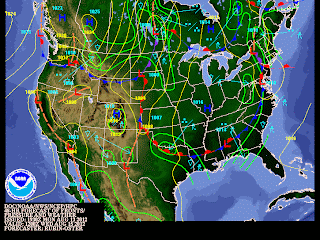
Showers and Storms will be likely throughout the day on Sunday in Southern Manitoba, as the system pushes North. As shown by the NWS Weather Maps.
Potential for more showers on Monday


And quite the push it will be! Rain and Isolated Thunderstorms will be going on throughout Saturday night south of the border, although the storms will likely weaken by sunrise and the rain will slowly push northwards across the Red River Valley. Most regions across Southern Manitoba should expect the showers to start fairly early on Sunday and last throughout the day, with the possibility for the formation of non-severe storms especially in the RRV during the late afternoon,evening. The rain and possible storms will taper off west to east overnight and will clear out. With another potential for showers Monday as this significant weekend system brings wraparound showers, while it leaves our province. Overall rainfall amounts in Southern Manitoba can be expected to be in between 5 and 10mm in showers,(at least 30+mm) amounts in storms. And inbetween 20 and 30 mm in western manitoba where you will be closer to the heavier rain.This really isn't the best of news for this year's teddy bear picnic, but hopefully it won't dampen their fun and spirits. 

This likely will be the last cold blast of the season, before we start experiencing some warmer May like weather, and some hot June temperatures. That is a long ways away from now, so let's have a look at the improving weather after this rainfall....  Conditions do look like they will improve through the middle of next week, with temperatures pushing back towards the 20C degree mark and some sunny conditions making an appearance. In the mean time put on some PJ's or slippers and kick back and relax as this weekend will be a stay at home weekend. Except for the storm chasers out there who may want to storm chase on Sunday here or in North Dakota if conditions follow through.

Wednesday, April 25, 2012

Below Normal Temperatures Return

(850 MB Temps Forecast at 18Z Today)


(NWS GF Wx Graphic for Today)


Hello and we are back in operation, after a full week of waiting. So how is our weather holding up? After enjoying the past few days with temperatures a couple of degrees above the normal, a low pressure system backing into Hudson bay will push a cold front southwards across Southern Manitoba throughout the day today. It will bring along with it cooler weather. The cold front will sweep by southern manitoba early this afternoon, with winds forecast to pick up from the North and increase towards 30 and 40 km/h. Scattered showers will develop along and ahead of the front as it pushes south through the red river valley, from the interlake. So most areas in the red river valley will have a chance of seeing some rain early this afternoon. They won't last long though, and as well cooler air will stream on the backside limiting our temps to only get to the low teens for today across the south. Skies will clear quickly tonight as an Arctic high pressure ridge builds in. This cooler weather will continue until the weekend when we see this ridge move off and slowly allow for our temperatures to rebound, although the day on Saturday still may be cool. I will let you know when we can expect a warm up in terms of temperatures.

Also in Weather News I am watching the potential for development of El Nino by the end of the month in the pacific. This would mean a potential for a hotter/more humid and wetter summer in parts of Southern Manitoba. (As Depicted to the left from NOAA). I will keep everyone updated on this as it unfolds

Featured Post

Showers and Thunderstorms likely tonight

 Southern Manitoba will be likely getting severe weather this evening and overnight as another round of severe storms is possible, thanks to...