Showing posts with label Becoming Mild. Show all posts

Friday, August 17, 2012

Cool Weather For The Next Few Days, Returning to Seasonal Temperatures By the Start of Next Week

We’ll see fairly seasonal weather over the weekend with overnight lows that will start off cool but climb back towards normal as well.
With The Jet Stream Struggling to push eastwards on Saturday the cool air will remain over NW Ontario and Southern Manitoba. Leaving behind the major warmth in British Columbia and Alberta. The Jet Stream will push eastwards slowly throughout the start of the week bringing warmer weather hopefully. 

After a beautiful day today we will see some cloudcover tomorrow as a trough travels south through the Red River Valley with a chance for some showers and maybe a thunderstorm before things clear out by evening. This will result in the temperatures staying fairly cool with them likely being in the low 20's in the Red River Valley, as cool air filters in behind the system. Although warmer weather will be in store for SW Manitoba where the sun will stay out pretty much all day.

The weekend will end sunny with temperatures climbing back into the upper twenties with the trend continuing into next week. Our next chance of precipitation could be on Tuesday Morning at 7am as another cold front slides south, the chances for precipitation at the moment are only looking to be 20%. I will keep everyone up to date on Twitter. Other than that the seasonal weather looks to take over once again!

Wednesday, June 20, 2012

Another Stormy Day On The Way Tomorrow; Warmer Weather on the Way

Possible showers and storms tomorrow will be welcomed with upper level ridging that will allow for our temperatures to start rising into the 20's and even low 30's later this week into the weekend and next week.
Showers And Storms Likely Tomorrow from Noon Through the Evening hours, in the Interlakes, Winnipeg and most of the Red River Valley.
The rest of the showers and storms will taper off this evening as they move into Ontario along with the main area of low pressure, leaving behind it conditions ranging from partly cloudy to clear across the Southern half of the province. Although temperatures won't be too bad, likely near the  low double digit ranges in all regions of the province it will provide for a very comfortable evening if you are heading out. Tomorrow will be a similar story but not as cloudy. The sun will be out throughout the morning and early afternoon hours allowing our temperatures in Southern Manitoba to rise into the high teens and low twenties, before another small front brushes past the province in the afternoon and evening. As this front slides by expect the formation of showers and storms in the Red River Valley and Eastern Manitoba as the daytime heating is combined with an area of lift along the front. Storms will generally be non severe in nature, although a few could reach severe limits for hail up to toonies and heavy rainfall.
Ridging will build into this weekend
Tomorrow will also mark a shift in our weather pattern, as a ridge starts to build into the province getting our temperatures into a warming trend. That ridge will continue to build into the weekend letting Sunshine take hold over the province and aid in getting a boost of our temperatures and humidity levels. It is definitely going to give us some time to dry out, especially for those in SW Manitoba who have received well over 240mm of rain in the past few weeks.

Today's Tip: A look at the legend of the NWS Weather Map (top picture) 

Wednesday, June 6, 2012

Our Hot Week Set to End with a Bang!

(Information Provided by Brad from A Weather Moment)

Temperatures are ready to soar for the rest of the week as a heat source from the Gulf of Mexico builds into the southern portion of the province. Everyone across all of Southern Manitoba should begin to prepare for a potentially dangerous end of week powerful low pressure system that will threaten the first significant severe weather outbreak of the season.

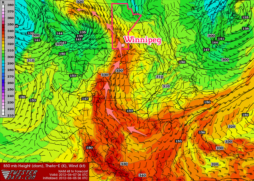
850mb theta-e (a form of measuring temperature) chart valid for 06Z Thursday 07 June


The above picture with the red arrows very well depicts the advection of a warm Gulf of Mexico airmass into our region, (theta-e is basically a form of measuring temperature). A southerly flow aloft, aided by a long wave trough over British Columbia to our west and a blocking high to our East will bring us the hottest days we have experienced this year, throughout the rest of this week. Temperatures are expected to reach the 25C to 30C range through the second half of this week.       
Postion of fronts and weather at 00Z Friday
 A weak low pressure system will move through Southern Manitoba throughout Thursday night, ahead of the main upper level feature. Even though dynamics don't look to great for severe weather, a line of thunderstorms will likely develop during the late afternoon and evening hours they will intensify aqnd slowly move east-northeastwards. While tornadoes will not be likely with the storms on Thursday afternoon/evening, CAPE values near 1250 to 1750 J/kg combined with Lifted Indicies near -5 and 20 to 30 Shear should be enough for large hail according to Brad. The possible slow moving nature of the line of storms could produce a risk for heavy rainfall with as much as 30+mm falling over a short period of time. While showers will be common over the southwest portion of the province on Thursday, the chance for showers does extend eastwards through the Red River Valley in the afternoon. Most of the precipitation will fall with the thunderstorms that will develop in the evening.

Although this is still 36 hours away and things could change a lot between now and then. According to Brad "models still are having a hard degrading the blocking pattern that is in place right now ,and some are much more progressive with features and some are much slower."  If things end up more progressive than the look now, there may be a small storm threat for Thursday night.


Thunderstorm Outlook for Night 2 (00Z to 18Z June 08).
Brad says " That taking into account the various speeds, the current area that might see storms on Thursday afternoon/evening looks to be the area bounded from the US border north to Brandon, up towards Dauphin/Swan River, then eastwards across the Interlake and southwards down the eastern Red River Valley. Storms will exit through the Central/Northern Whiteshell. Friday will yet again be another warm day;debris cloud left behind from Thursday Night's convection should clear around lunch time which will hopefully allow the sunshine to warm us to the mid to high 20's. Dewpoints look to build in the afternoon pushing up to the 18C or 19C degrees making it feel quite humid. The main frontal system is set to move in on the weekend, and what a system it looks to be.

SPC Day 4-8 Severe Thunderstorm Outlook


According to Brad "We’ll be under the influence of two strong shortwaves that will push copious amounts of instability over Southern Manitoba. CAPE values look to exceed 2500 J/kg and potentially be as high as 5000-5500 J/kg; this, combined with a weak cap north of the warm front and favorable shear profiles looks to point at a potent setup for severe thunderstorms with high probabilities of (extremely) large hail, strong winds, and elevated risks of tornadoes." From My perspective it looks like this setup will be similar to June 22nd and 23rd 2007 tornado event that featured Canada's first F5 Tornado in Elie and that also resulted in 6 other dangerous tornadoes in Southwestern Manitoba.

More Details will be available throughout the next couple days on Twitter and some on my blog post on this potentially serious Storm Outbreak.

Monday, June 4, 2012

Hot and Wonderful Start to June....

After a beautiful weekend mixed in with Stormy Conditions, we will end up sticking with the hot weather to start the week. An omega block will start to gradually build in this week, allowing us to keep experiencing the warm weather we have had over the past week.

Omega block building in for midweek
Day 6 and 7 outlook from the SPC
 Tuesday will be the nicest and hottest day of the week with high temperatures cracking the 30C mark, along with sunny conditions, low humidity and a comfortable breeze. Temperatures will be pretty much the same for Wednesday with highs again near 30C, as we grab a little bit of a south-easterly flow. Thursday looks to remain very warm, and continue into the first half of the weekend with an increased chance for storm activity as another low pressure system approaches from the plains. The SPC has even highlighted a day 6 and 7 outlook for our area, mentioning a 30%+ chance of seeing any severe storm within a 25 mile radius. I will keep you up to date as this progresses, and a post will be available on Friday on this storm system.

Wednesday, May 30, 2012

A Look Back At The Month of May, And A Chance For Us To Dry Out A Little Bit......

(Info Provided in part by Brad from A Weather Moment,
and other details by Mike the Author of this blog)


After Seeing deluges of rain over the past 10 days Southern Manitoba is finally forecast to see some sunny dry weather conditions. A high pressure system will move through our area allowing for sunny skies over the next couple of days, with daytime highs pushing back to the seasonal normal. That is about 21C for Brandon, 22C for Portage La Prairie and Winnipeg.
 Overall Precipitation Average through the month of May
Focusing on Winnipeg, we are absolutely soaked, according to Brad from AWM "So far this month, many areas of the city have seen over 100mm (3.94”) of rain, with some areas of the west end seeing closer to 125mm (4.92”)." This is definitely a huge amount of rainfall for a single in Winnipeg; the Manitoba Agricultural department released a report showing that Winnipeg has had 46% more rainfall than normal over the last 30 days. Brandon has also had close to 50% more rainfall than normal in a 30 day period, although a little less up in Dauphin and areas along the International Border where drier conditions persist. This wetter than normal month has broken a 9-month stretch of drier than normal conditions for parts of Winnipeg and the city has already shattered last years total summer precipitation. If summer is considered the months of June, July and August, our 100-125mm of precipitation in Winnipeg this month smashes the 93mm we received throughout the Summer of 2011. As well through the summer last year only 7 days the airport reported thunderstorms in the area. So far in May alone we have reported 5 thunderstorms, put that on top of the other 5 we experienced in March and April altogether we have seen 10+ thunderstorms. Looks like we are leaving 2011 in the dust in terms of our storm activity. Overall we are off to a wet start to the summer that has definitely been more promising on our storm front than last year.

Time for our Weather outlook.....
Positioning of the high pressure system at Noon Today
Over the next couple days, we will see the sun and the return of warmer temperatures. An area of high pressure will continue moving our region tonight before it enters NW Ontario Tomorrow allowing for a southwest flow to take place, bringing some warmer weather for the day. We will see a small chance for some showers and possible thunderstorms on Friday Afternoon as a trough pushes through the Red River Valley, bringing our temperatures up into the mid to high twenties for the weekend.

Featured Post

Active weekend on the way to Manitoba

Well another weekend of active weather is set to impact southern Manitoba this weekend, thanks to a large trough setting up over western Can...