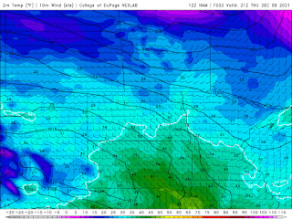
Much of southern Manitoba will be getting a return to warmer weather, all thanks to a warm front moving into southern sections of Manitoba today. There will be a longer period of warmer weather, thanks to a westerly flow with slight ridging occurring. Find out how long this will last for and how warm it will get.
(Above):Warm day ahead for Thursday, temperatures getting close to zero degrees for the day. Temperature unit is in Fahrenheit.
Wednesday: Much of southern sections of the province will deal with cloudy skies during the day , a band of snow will move into the region this late afternoon with a warm front as it moves in. It’ll end up bringing light snowfall with periods of blowing snow. Accumulations will vary between 2-7cm. Temperatures will warm up around the high minus single digits (-5 to -10C) for areas along and south of the Trans Canada highway , areas further north will still have to contend with daytime high temperatures in the low minus teens (-10 to -15C). Wednesday night: Snow should end this evening , then Cloudy skies should dominate the pattern , with a chance of flurries in the south central and southeastern sections. Temperatures will take a boost thanks to a southerly flow establishing itself as a high pressure system moves eastwards, and we end up on the backside of it. Temperatures will warm (Weather joke here: Temperatures they won’t be taking a energy drink , although it will sure feel like it 🤣🤣🤣) up well into the mid to low minus single digits overnight (-7C to -3C).
Thursday and Friday: Much of southern sections of Manitoba can look forward to warm weather, temperatures on Thursday will soar well into the mid to high single digits (-1 to -6C). Sunny skies are also likely as well which will help it feel a little warmer. Temperatures on Thursday night will drop into the low minus teens (-10 to -15C). Friday will be much of the same where high temperatures will rise into the mid to high minus single digits (-5 to -10C) for the day. Heading into Friday night much of the region will unfortunately see lows dipping quite a bit, as a high pressure system sits over the western mountains in the states, giving us a cool northwesterly flow. Temperatures will drop into the low minus teens to the high minus teens. (-10 to -19C). Only the warmer temperatures in the low minus teens will be in the southeast, everywhere else will see the chills of winter. I’m sure the windchills will end up in the minus 20’s overnight.
Weekend Details: Sunny skies are expected through the weekend, another low pressure system will swing through on Saturday and Saturday night. We won’t be expecting any impacts from this system as it moves in. Temperatures will once again hit the high minus single digits to the low minus teens on Saturday (-7 to -12C). Saturday night temperatures will rise into the mid to low minus single digits (-2 to -5C) as the warm front moves in. Temperatures will really end up being on the upswing, Sunday when high temperatures will rise into the low to mid plus side of the single digits (1 to 5C). I was looking over some of the record temperatures and record high temperatures look attainable on Sunday if it gets anywhere over 1C. However because of the sun angle not a lot of melting will take place. This is bizarre for December to say the least. I am seeing the possibility of frigid overnight lows in the low minus teens to high minus teens on Sunday night about -13 to -16C. You can thank this to a cold front swinging through in the evening on Sunday, it might end up bringing a chance for flurries but we’ll know more on the Friday update .
-Mike McGregor


No comments:
Post a Comment
Thank's for commenting on the blog, I appreciate it...