Welcome back to Winter Wonderland in southern Manitoba, the snow is on the ground, the windchill is high and the roads are icy. For those thinking that summer would stay, unfortunately as the tilting of the sun and rotation of the earth winter has to come. Well the reality of it is you can thank this cold weather due to a polar vortex that is beginning to sink south over the Canadian prairies. That is detailed below in probably one of the coldest temperature values I have seen in a very long time, that below is on Friday afternoon 🥶🥶🥶. Find out how cold it will get and what we can expect weather wise, in southern sections of Manitoba.
Tonight: We will be sitting on the edge of an arctic high pressure system as we experience a northwesterly flow aloft our temperatures tonight will be cold, crisp and arctic like. A good majority of our region will see overnight lows in the mid to high minus teens, with windchill values in the mid to high minus 20’s if you are in the Swan River and Assessippi Provincial park regions chances are windchills could be approaching minus 30C. Very little in the way of cloud is expected over all regions tonight.
Extra Feature:

Thursday: For those wondering about some milder temperatures, Thursday is pulling I guess a winter prank. A low pressure system will be skirting the USA border and with that it will bring in a batch of cloudcover, there will be some periods of sun mixed in. So sun and cloud likely on the day. Temperatures will warm up and they will turn out milder than all of this past week, high values will rise into the mid to high minus single digits. Windchills may feel slightly colder than that. In the evening hours a batch of snow and light snow will likely develop in southwest Manitoba.
Thursday night: A low pressure system off to the south of us will pull in a cold arctic airmass as we sit on the north side of the low, a good chance of snow on the backside will likely bring 3-5cm. Depending on the intensity there will likely be some heavier bands but brief. Temperatures on Thursday night will stay mild in the southeast with temperatures in the high minus single digits, and areas just west of Elie seeing values in the low minus teens. Windchills will only be in the low minus teens in the southeast further west with values in the mid to high minus teens. Further north in the parklands a higher chance of values in the low minus 20’s. A large area expected to see snowfall, regardless of temperatures.
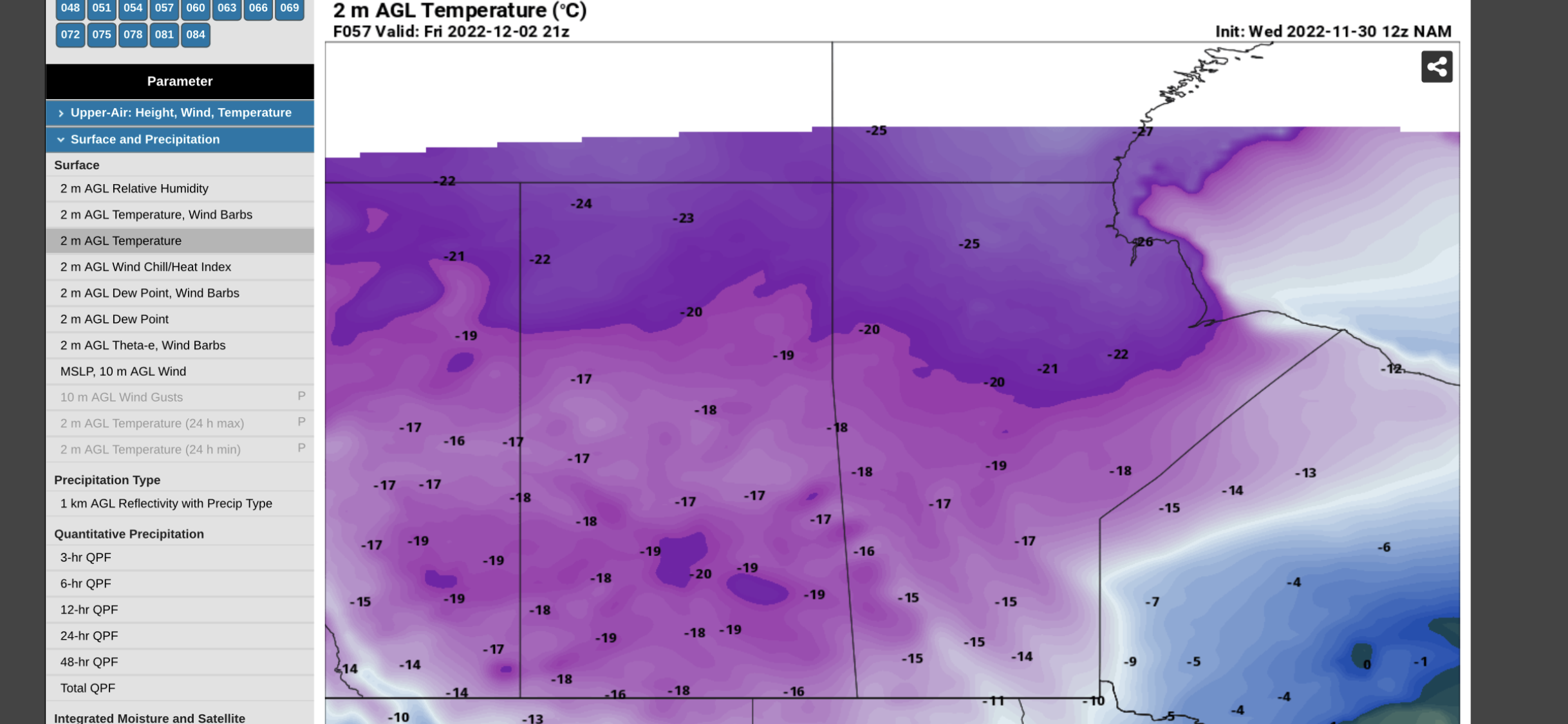
Friday: Remnants of the low pressure system will move over southern Manitoba before going into Ontario in the later half of the day . Temperatures will only get colder behind an arctic cold front that will be sitting over the Canadian prairie provinces snow will begin to taper off towards the late morning hours to early afternoon. High temperatures will only be reached in the late morning to early afternoon hours in the low to teens for most. However most of the temperatures will drop by the late afternoon well into the mid to high minus teens by evening most of our area will be seeing wind chill values well into the mid to high minus 20’s, before dropping close to -30C (I mean -26 to -29C ) for a large majority of the south. Frostbite will be possible in minutes.
Friday Night: Clearing will be likely with a majority of temperatures dropping well into the high minus teens to low minus 20’s. Windchills will likely sit well into the high minus 20’s and low minus 30’s. This is the kind of cold that can cause frostbite and becomes dangerous if skin is left exposed. Please dress warmly and stay indoors if you can.
The Weekend: Another day of sunny skies is likely on Saturday. As well another batch of snow is likely on Sunday with about 1-3cm likely. Temperatures will warm into the high minus single digits closer to -10C on Saturday. Saturday highs should be stable and sit in the mid to high minus teens, Saturday night lows will rise into the low to mid minus teens, as snow builds in. Sunday will see similar temperatures with most areas seeing highs in the low to mid minus single digits. Warmer than earlier in the week. That cold builds right back in overnight well into the mid to high minus teens, areas in the inter lakes and parklands will see values well into the high minus teens with windchills in the minus 20’s.
Enjoy the rest of the week and the weekend. -Mike


Great information, thanks for your time and knowledge!
ReplyDelete