Good evening everyone I have a weather blog update for the weather for the beginning part of the week there's some interesting weather forecast with the potential for some severe weather on the day Wednesday afternoon will get into that shortly. Looks like a broad area of low pressure will be swinging through the central and eastern Prairie provinces with the possibility of bringing with it some unsettled weather and temperatures around normal.
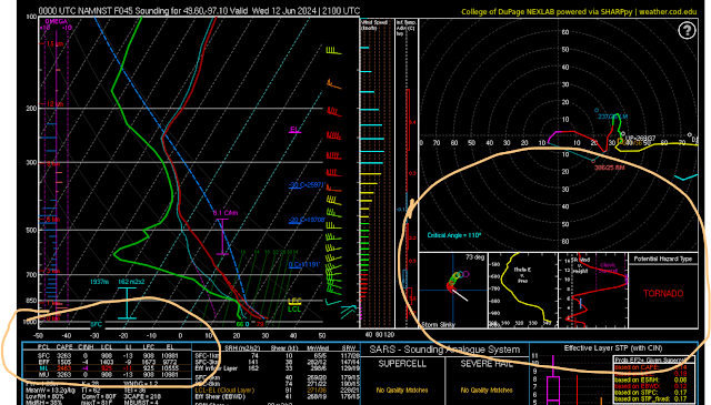
Above photo of severe thunderstorm risk on Wednesday (Top Photo) followed by the NAM weather model on the (bottom photo) showing the SKEW T Graph threat of severe thunderstorms on Wednesday just South of Winnipeg this may also change depending on the updated model runs over the next 24 to 48 hours.
Tonight an area of low pressure will be moving through southern sections of Manitoba with the possibility of mainly cloudy skies and mostly rain heading into the overnight. General rainfall amounts expected to be between, 10 to fifteen millimeters of rain the most rainfall is likely to fall in southwestern parts of Manitoba up into the Manitoba Scarpent and the east part of western Manitoba near Riding Mountain National Park. By morning a majority of the rain should be out of the province there should be a possibility of showers in the Interlake region as the area of low pressure begins To move SE. Temperatures tonight will drop into the mid to low teens areas of the Interlakes and expect to be seeing temperatures closer to the 10 degrees Celsius marked with the cooler lake waters in those areas.
The weather on Tuesday afternoon should clear out with sunny skies forecast temperatures getting into the upper teens and lower 20s especially if you're in areas closer to the American border. There will be a chance for some scattered showers and weak thunderstorms during the afternoon with very little instability in place expect them to be non severe in nature. A more robust chance of thunder storms are possible on the day on Wednesday. Tuesday night looks like a warm front will approach our region ahead of it there will be a chance for some weak showers or scattered showers during the morning hours overnight low temperatures will be in the mid teens with areas of the Inter Lakes again seeing temperatures in the lower teens.
On Wednesday this is when the weather gets concerning a area of low pressure will be off to our north another one be moving through southeastern Manitoba into northwestern Ontario. Temperatures Will be rising into the mid it to high 20s especially in areas of the Red River Valley and Southeastern Manitoba, along with it high levels of instability. We are generally looking at convective available potential energy values between one thousand five hundred and two thousand five hundred along with Bulk shear between 25 and 45 knots. It looks like the threat for severe thunderstorms will develop during the afternoon and evening in south central and eastern Manitoba there is also a possibility that this risk area could shift a bit further to the West depending on how far east the frontal system decides to move on the day Wednesday. There is an indication during the afternoon that thunderstorms will develop in southwestern Manitoba moving east into the more unstable air mass there will be a possibility of tornadoes happening during the afternoon and evening hours. The risk will be low for tornadoes however. I've looked over several models and the super cell composite as well as significant tornado parameter are on the lower end which shows that there is a slight risk for tornadoes. Areas included are from Brandon to Winnipeg, east to the whiteshell then south to the american border. Also we're not looking at anything that would be considered a more substantial level which you would get in July or August. Bottom line if storms can hold off till a little bit later in the day they may be a little bit more significant however they look like majority of the storms will fire shortly after lunchtime or in the early to mid afternoon hours with very little capping in place these storms may not reach the significant levels that we get in the United States. Regardless look for a risk for a severe thunderstorms on the day Wednesday with large hail damaging winds and torrential rain. Will also be quite humid our humidx values will likely reach the mid 30s during the afternoon on Wednesday. Justin or I will have a updates on this weather threat on the morning hours or late morning early afternoon on Wednesday.
Calmer weather is likely for the second half of the week with temperatures in the upper teens lower 20s possibilities of mid 20s as well, there will be a chance for some showers on Thursday followed by calmer conditions on Friday. However more unsettled weather is likely for the weekend as more areas of low pressure move into southern Manitoba with more instability coming in from the United States, it looks like this is a start to what could be our storm season as June is a more active month on average.


No comments:
Post a Comment
Thank's for commenting on the blog, I appreciate it...