Southern Manitoba is expected to be impacted by a Colorado low overnight tonight into early Tuesday, light snow and deteriorating conditions are already occurring with reports of highways being snow covered with blowing snow and poor visibilities. No highways have been closed as of yet, however closures may result as snow accumulates and roadways start becoming difficult and dangerous for travel especially with blowing snow, and poor visibility.
Snow impacting much of Southern Manitoba, as moisture streams in from the south, (from Rain Viewer IOS at 10:05pm)
Snowfall warnings are in place for a wide swath of southern Manitoba including the city of Winnipeg, city of Morden, city of Winkler, city of Steinbach and the city of Brandon.
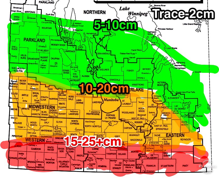
Current thinking is that most areas running from south of the Trans Canada Highway especially from the USA Border towards the corridor of Highway 2 could pick up as much as 15 to 25+cm, areas running from the Trans Canada highway from Elkhorn to just south of Whitemouth including Winnipeg and Brandon could 10-20cm. From the parklands by Russell into the inter lakes, and eastern Manitoba by Bissett could get 5-10cm. Areas by the lakes will get a Trace to 5cm. Keep in mind the snow we get will be light and fluffy, as temperatures remain too cold to hold a lot of moisture in the snow, not a lot of water content in the snow. So it’ll be easier to shovel. Current Guidance suggests that this system will have some brisk northerly winds to about 15 to 30km/h gusting to 50km/h at times. Highway travel will be rough, that is why me and Justin will be posting highway travel updates. I wouldn’t suggest any one travel, but if you are going to please don’t forget to bring your travel kit with you, or youll end up becoming like the abominable snow man while you look for help. 😂😂😂 No one wants to end up seeing you covered in snow with your eyebrows frozen and face snow covered, you may end up causing an accident and both of you may end up becoming like the abominable snow man and stranded for good. 😂😂 Once this system clears out on Tuesday evening we should end up getting light snow behind the system. There will be cold north winds coming in behind this system , windchill values will go from being at minus 20 on Monday into the minus 30s and minus 40’s for the middle of the week into the weekend.
Stay tuned for updates on Manitoba Weather Center with me and Justin.


thanks!great information about pesky weather. our cats wanted the snow in winnipeg to be 3 dogs deep! may all be safe!
ReplyDelete