Much of our region has experienced a lot of winter weather over the past few months, and once again a Alberta clipper will provide significant winter weather conditions that will impact our area. It’s already starting to make it’s presence known as freezing rain has already been swinging through southwestern sections up towards Brandon and Dauphin as it makes its way east. There will be other winter weather impacts, and as a result environment Canada has issued a blizzard warning for this event. Find out when , where and how this winter storm will affect us below.

(Above) During the afternoon today temperatures will warm into the low plus single digits (1 to 3C) in areas of southwestern Manitoba, whereas areas of the southeast will see highs in the low minus single digits (-1 to -4C) a cold front will move across the region associated with an Alberta clipper system, out ahead of it a band of rain, freezing rain and mixed precipitation or snow will continue to make its way east to the red river valley by evening where it will likely transition over to snow. Temperatures in this area will be cooler than the southwest.

Tonight (Above): A large swath of heavy snow will sit over the red river valley and eastern Manitoba, this is when the snow may be at its heaviest with snowfall rates as high as 2-5cm an hour during the evening. The cold front will pass shortly after midnight, allowing for a wide swath of snow to move south and east as winds intensify to 70 gusting to 80km/h. Snowfall totals will range between 5-10cm in the southwest to as much as 10-15cm in the southeast. (Snowfall totals map below)

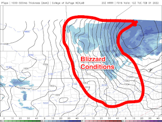
Blizzard conditions are expected to develop in the parklands and western Manitoba before it will move into the Red river valley and eastern Manitoba by the early morning, between 3am and 6am. What this means is that a large portion of our forecast area will see winds at 60km/h consistently with gusts up to 80km/h. Temperatures will also take a nosedive with a majority of the region seeing overnight lows on Monday night dropping into the mid to high minus teens (-12 to -18C), with windchill values in the mid to high minus 20’s (-25 to -29C).
Tonight: Winnipeg: 60% chance of flurries this evening with risk of freezing rain, snow at times heavy with blowing snow beginning early this evening. Blizzard developing after midnight. Reduced visibilities with near zero visibility at times. Low -13C, windchill -25C. Brandon: Snow. Blizzard developing near midnight. Risk of freezing rain this evening. Snowfall amount 5 cm. Wind south 20 km/h becoming west 20 early this evening then northwest 40 gusting to 70 near midnight. Low minus 16. Wind chill minus 29 overnight. Risk of frostbite. Dauphin: Snow. Blizzard developing near midnight. Snowfall amount 5 to 10 cm. Wind becoming north 20 km/h early this evening then increasing to 40 gusting to 70 near midnight. Low minus 16. Wind chill minus 10 this evening and minus 29 overnight. Risk of frostbite.

Tuesday: As the low pressure system exits the province on the backside of the system strong northwesterly winds will continue with winds gusting as high as 80-90km/h. Blizzard conditions will continue into the afternoon, with conditions improving from west to east by late afternoon into the evening hours. Regardless I’m expecting the heavy cloudcover that’s part of the system will also move east throughout the day from around morning in the extreme southwest to around lunch time by Brandon, clearing in the early evening in the red river valley and southeastern Manitoba by the evening hours.
Temperatures on Tuesday will take a nosedive with a large portion of the south seeing temperatures in the high minus teens and the low minus twenties with the coldest of the weather in the southwest. Expect (-18 to -22C), windchills will exceed the high minus twenties and the low minus 30’s (-29C to -34C). Outlook: Winnipeg: Blizzard ending near noon then snow and blowing snow. Wind northwest 60 km/h gusting to 80 diminishing to 40 gusting to 60 near noon. Temperature falling to minus 20 in the afternoon. Wind chill near minus 33. Risk of frostbite. Brandon: Blizzard ending in the morning then mainly cloudy with 60 percent chance of light snow. Blowing snow late in the morning and early afternoon. Wind northwest 40 km/h gusting to 60. Temperature falling to minus 19 in the afternoon. Wind chill near minus 30. Risk of frostbite. UV index 1 or low. Dauphin: Cloudy with 60 percent chance of blizzard early in the morning then 60 percent chance of snow late in the morning then a mix of sun and cloud. Blowing snow late in the morning and early afternoon. Wind north 40 km/h gusting to 70 becoming northwest 20 gusting to 40 in the afternoon. Temperature falling to minus 20 in the afternoon. Wind chill near minus 31. Risk of frostbite.
Tuesday night: Clear skies will allow for a massive drop in temperatures (not literally but it’ll feel like someone flipped a switch and turned on the freezer full blast. Thanks Jack Frost 🤣🤣.), our overnight lows will drop well into the high minus twenties and low minus 30’s (-27 to -30C), with our windchills seeing the high minus thirties and low minus forties (-37C to -42C, or -44C). Extreme cold warnings might be issued as well because of this possibility. Winnipeg: Clearing in the evening. Wind northwest 20 km/h gusting to 40 becoming light overnight. Low minus 30. Wind chill minus 30 in the evening and minus 39 overnight. Risk of frostbite. Brandon: A few clouds. Wind northwest 20 km/h becoming light overnight. Low minus 28. Wind chill minus 29 in the evening and minus 39 overnight. Risk of frostbite. Dauphin: Partly cloudy. Wind northwest 20 km/h becoming light in the evening. Low minus 25. Wind chill minus 29 in the evening and minus 35 overnight. Risk of frostbite.
Wednesday and Wednesday Night: Much of the region will be under the presence of arctic high pressure which will allow for sunny skies and cold temperatures which will continue to stick around. Temperatures will stick in the low to mid minus twenties (-20 to -25C), windchills will likely sit in the low to mid minus thirties for the day (-32 to -36C). Wednesday night will offer much of the same, overnight lows will plummet well into the mid to high minus thirties (-35 to -39C), a likelihood that our windchills will see a return to the low minus forties and low minus fifties, yes you read that . -50S. There is a chance a few locales near Brandon and Dauphin could surpass minus 50C windchill. Thanks Jack Frost 🥶😩😩. Winnipeg: Sunny. High minus 21. Night: Clear. Low minus 33. Brandon: Sunny. High minus 20. Night: Clear. Low minus 37. Dauphin: Sunny. High minus 19. Night: Clear. Low minus 31
A full update on the second half of the week will come on Thursday. -Mike McGregor


No comments:
Post a Comment
Thank's for commenting on the blog, I appreciate it...