Tuesday, April 25, 2023

Mild Spring Weather Pattern Continues

 Well it’s true much of our region has been well below normal this season, that pattern has thankfully finally changed. We now begin this half of the week with more normal temperatures, however there once again is a caveat to this. We have another chance at getting a low pressure system that will begin effecting our weather outlook, the good news however is that this will likely come in the form of rain. Find out where, when and how much rain is expected as well what we can expect for our temperature pattern. Which I am glad to say in that we are done with winter weather terms, I look forwards to posting about convection and thunderstorms in the coming months. I really enjoy this part of my job, maybe the next few months you’ll hear some weather jokes from me . 😊😊. 


We’re gonna keep this post short and simple. Wednesday looks to be one of those days you want to bring your rain jackets and umbrellas, There will be an increasing cloud cover over the region as a frontal system approaches our region. A general 5 to 10mm is likely as the front moves through from west to east.


Another thing to note is the intensity of the rainfall, theres a possibility that there will be thunderstorms (Above photo) embedded with the rainfall however it’ll be occasional lightning and thunder as a chance. Temperatures will vary from being in the upper single digits in the southeast to the low teens in the southwest and parklands thanks to sunny skies in the west after the clipper passes. Wednesday night will feature a chance for isolated showers and weak thunder showers in the interlakes during the first half of the evening before clearing overnight. Temperatures will stay a degree or 2 above zero except for areas in the interlakes, red River valley and southeast where a chance for lows below zero (-1C to -2C) possible.

Thursday:  Sunnier skies are likely for most, except areas of extreme south there will be a chance for showers in extreme southwestern Manitoba and areas along the border as a low pressure system travels southeast into North Dakota. Temperatures will likely rise into the mid to high single digits in the south along the border and areas in the parklands by Dauphin up to Swan River. Areas across the southern half of Manitoba will do well again with values pushing past the 10C mark, if we get values 10-12C it would be in cloud free locations mostly all of the south including the interlakes. Thursday night: Mostly cloudy to partly cloudy skies are likely with overnight lows dipping into the low plus single digits (1 to 4C) with areas varying in values. Unfortunately this time of year a rural area can be a lot cooler than an area in the city limits, temperatures at night are still running well below the average. 

Friday and Friday Night: Another area of low pressure will likely sit along the border and a small chance of showers will likely present itself as a northwest flow sits over our area towards the evening. Temperatures are likely to rise into the high single digits, with some areas in the east rising to near 10C. Mostly cloudy skies are likely, again heading into Friday night a likelihood of scattered showers moving southeast and a small chance of flurries in the northern parklands by Swan River. Temperatures will drop on the night into the low single digits. 

The weekend and next week: Temperatures will remain cooler than average as we remain on the backside of a strong low pressure system, temperatures will struggle to reach the 10C mark for day time highs and overnight lows may plunge to the low single digits or a few degrees below 0C for overnight lows. However there is good news that by next week our daytime highs will finally rise to where they are supposed to be , and May in fact rise towards and possibly above 20C for the first time this year. This warmth may be the first real summer heat of the season. 

Tuesday, April 18, 2023

Get Ready for Another Snowstorm??!! Colorado Low Pressure System Set To Impact Manitoba, Again??

Much of southern Manitoba will likely be under the gun again for significant winter weather and the likelihood of snow and blowing snow, there will be a colorado low coming up from the United States which will feed on gulf moisture on the south end of the system. I honestly hope this will be the last snowstorm to talk about this coming year. Anyways let’s have a look at the latest information that I have been able to look at through the HRRR, NAMNest and the NAM4km. 

Tonight: South of the border an area of thunderstorms will develop in North Dakota and will impact areas around Fargo. Further North snow and blowing snow will be impacting areas of western North Dakota which will likely not impact our region until morning. So there will be a bit of reprieve before the main event begins. Overnight low temperatures will drop into the low minus single digits, except for areas of the red River valley where lows will stay around 0C. Below are photos of precipitation for Wednesday morning, in 2 scenarios, and Wednesday afternoon as well. 

Scenario 1: Above

Scenario 2 Below:


Scenario 1: 


Scenario 2:


Wednesday: This is by far a tricky forecast so expect 2 scenarios for the day.  During the morning (above) a squall line of heavy snow could develop and push through southern Manitoba which would be the first scenario, (Above) with it there will be a hazard of freezing rain for areas along the border. Which later in the day, snow will likely move through the entire half of Manitoba.  Scenario 2: A large swath of snow moves into Manitoba with areas along the international border showing a risk for freezing rain and or sleet/ice pellets. As this lifts North the risk of freezing rain and rain will begin to fill in across the southeast and south central parts of Manitoba. There is some concern for extended periods of freezing rain in western Manitoba during the day time. Mixed precipitation will be likely in areas of the red river valley west towards Brandon and the parklands until about later on in the day. Things will likely taper off by the evening. Areas further west will be under the brunt of the heavy snowfall,, snow and blowing snow there will reduce visibility to near 0km at times. Highway travel will be impossible at points, however Saskatchewan looks to bear the brunt of the heavy snow on Wednesday. Read to the end to find out rainfall and snowfall totals. Temperatures on the day Wednesday will rise into the low minus single digits for some areas a degree or 2 above zero. 


Wednesday Night (Above): A full transition over to snowfall is likely as temperatures drop overnight, the snow will be covering pretty much all of the region as far North as the north interlakes. The low pressure system moves further east we will begin to switch over to the backside of the system. Snow and blowing snow at times may be heavy, winds will also gust to over 60km/h at times. Temperatures will likely stay at or slightly below zero for a large region of the south (-2C to +1C).   


Thursday (Above): Heavy snowfall will likely develop across southeastern regions of southern Manitoba, before it reaches all of southern sections Manitoba. It will also likely be a wet snow as temperatures will be close to the freezing mark, near the -1 to -3C range. I am concerned about the chance that given such tight gradients that winds could likely exceed 50-70km/h. Highway travel will not be advised during the day Thursday. 


Thursday Night (Above): Snow and blowing snow will continue as a double barrled low pressure system will spill moisture in from Ontario, if you’re wondering on the night Thursday if any of the snow will be less heavy. The good news is that I can tell you that it will likely be more on the moderate strength. The only concerns I have is given the prolonged nature of this snow as you will read more below is highway closures. Overnight low temperatures will drop into the low minus single digits varying temperatures (-1 to -4C). 


Friday (Above): Snow and blowing snow will be less severe on the day Friday, there will be periods of heavier snow however winds will likely still gust up to 70km/h at times. This system will not wane down until at least Friday night. Winds will also begin to blow out of the northwest, word of encouragement if we were to go back 2 months a northwest wind would give us windchills of -20C or more. So I consider +1C to +3C a blessing, which will be our day time highs on Friday.


Friday night (Above): Snow will begin to taper off, and calmer weather will arrive finally. Overnight clearing is possible and low temperatures will drop from as warm as -4C in the east to as cold as -8C in the west. Simply put well below average. 


Snowfall Totals: Much of southern sections of Manitoba look to have totals of 10 to 20cm from the border to the interlakes regions. A swath of snow from the pembina valley towards the parklands could get upwards of 30 to 40cm. Red River valley and the southwestern half of Manitoba 10 to 25+cm. So in general if melting occurs there could be a lot less accumulation than forecasted. 

 I know given that temperatures will be so close to above freezing this will be heavy wet snow. So there is a possibility of power outages across the south. Have a power outage plan in case you do lose power. Also do not travel unless you have to . 

Please stay tuned to Manitoba weather centre for updates as the storm evolves. 

Warmer weather will be arriving by the weekend with temperatures above the freezing mark likely, and overall higher values mid week next week. Same as well with overnight lows gradually rising. Our normals are around 12C and 3C for overnight lows. 

Saturday, April 8, 2023

Spring Melt Well Underway.

 The melt has begun over southern sections of Manitoba and the good news is that finally this trend looks to continue, I know a lot of you were very unhappy when I had wrote about snow and cold temperatures over and over again. Guess what?? You can now all be nice to me again . A strong pacific flow is allowing warm weather to move into our region. Let’s get into details for the weekend,, and the week ahead. You won’t want to miss it!! This blog will be short and brief. 😊


This weekend will be marked, by average temperatures with some of the warmest weather we have experienced in at least well since last year. A strong pacific flow has developed which is typical of spring weather patterns, this same jetstream pattern is what allows for that warmth to happen in BC during the winter months and that shift in the jetstream (above) will allow for that warmth to spread eastwards. 

This weekend a ridge will begin developing which will aid in temperatures reaching the mid to upper single digits for day time high temperatures, (5 to 8C) overnight low temperatures will be sitting a few degrees below zero on Saturday night and Sunday night with average temps of (0 to -5C). 

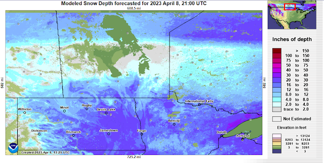
Overnight lows will gradually warm throughout the week with lows staying above zero degrees. There could be days this week where our high temperatures get above the 10C mark, especially on Tuesday-Thursday. The unfortunate thing however is given the fact we still have snow on the ground there is no way to tell how the snowpack will interact with the warmer temperatures, there is a risk that because of the amount of moisture being thrown into the atmosphere fog may become a common occurrence until the snow melts. Why is this?? for those wondering our dewpoint temperatures which I just had a glance at will sit above zero both overnight and during the day time, sitting fairly close to the actual temperatures. This means that the air will not freeze but will allow for liquid to stay in the air as the ground heats up then cools you get these fog patches at lower levels. That could hinder our day time high temperatures if fog develops. However either way you put it there will be a significant risk for flooding as the snow pack diminshes. The following graphics give you an idea of how much snow is left to melt. 


Unfortunately given that there is still between 2 to 16 or 18 inches of snow left to melt with snow water content from 1-10 inches and the ground is still frozen there will be a high chance that water may not be absorbed given the saturated ground. Please keep in mind that flooding will likely occur as the snow pack dissapears rapidly next week and given overnight low temperatures will stay above zero rapid melt is likely. Here is a place you can go to follow the flood situation: Hydrologic Forecast Centre | Manitoba Infrastructure | Province of Manitoba (gov.mb.ca) 

Looking at the long range this steady temperature pattern of highs in the mid to high single digits will continue with overnights possibly seeing lows below zero, but for the majority will remain above freezing. Next weekend there is a chance that there could be another colorado low at the end of the week on Friday with rain as a possibilty mainly. The chance of Snow is quite unlikely or low however. After that temperatures cool slightly with highs between 3 to 9C. I will watch this and update as the event draws nearer. 


Monday, April 3, 2023

Major Colorado Low Arriving, Winters Last Blast 💥 Warmth Likely to follow

UPDATE ON FORECAST SNOWFALL: Read the middle of the post please. 

Well, looks like this winter isn’t done yet, I know a lot of you are royally tired of winter and I am too. I don’t like these long drawn out updates on winter weather but here I am again with another weather update to make sure that at the end of this you smile and leave informed. I am not a meteorologist but a weather specialist so I don’t have knowledge in exact details on this storm. That is why I write these updates. Anyways what we are expecting is a major Colorado low and this system will not only impact a large portion of southern Manitoba but it will have a variety of weather impacts. It’s clear Mother Nature is having a bad temper tantrum or she’s throwing a really bad late April fools joke on us. 😕😕. 


A photo of the Colorado Low Pressure system, that will be sitting over Michigan by Wednesday morning. (above)

For those that just want an idea of what the storm is expected to bring. Here’s info to make it easier for you to know what details are in this post: Details on day to day weather conditions. Storm timing and weather impacts. Snowfall totals and wind outlook. 

Tuesday: A strong low pressure system will likely begin to develop south of the border, Tuesday will be a transition day with cloud cover increasing from the south ahead of the system. For those wondering the likelihood of significant winter weather likely won’t happen until at least Tuesday night. Temperatures on the day Tuesday will likely rise into the low to mid minus single digits (-1C to -5C).


Tuesday Night (Above): Much of southern Manitoba, will be included in the risk of increasing dangerous weather conditions by the morning hours. The Colorado low will be situated over Minnesota however the thing is with these systems is that they draw up moisture from the Gulf of Mexico and as a result the cold air on the backside of the system is entrenched in moisture and as a result can create heavy wet snow which will likely be the outcome of this system. Snow and blowing snow will begin lifting north of the border by the early evening to late evening and will likely occur as far north as highway 1 and the inter lakes into the southeast part of Manitoba, some areas of western Manitoba may see this system impact them as well. Models are predicting a northerly track which will reach as far North as the Ashern regions into central Manitoba. Highway conditions will be hazardous as the system hits our region. Overnight low temperatures will drop into the mid to high minus single digits (-4 to -7C).  

Wednesday (Above): This is when the bulk of the system will impact the areas included in the southeast and interlake regions, winds on the backside of this system will likely be very strong given the fact tight isobars or thermal gradients will be in place. There is a risk as mentioned by environment Canada for blizzard conditions to develop in some areas of the red river valley on Wednesday or earlier. Snow will be expected to be the heaviest during the earlier part of the day, before tapering off to moderate snow by the afternoon and evening. Do not go out unless you have to , I won’t be volunteering at Siloam mission on Wednesday because of the storm. Temperatures on the day Wednesday will rise into the mid to high minus single digits (-5 to -2C). 


Wednesday night (Above): Lingering snowfall will likely happen as this system begins to depart off to the east however, a strong northerly flow will still be present and there will be a risk for blizzard conditions or squalls. The good news is that it will begin to weaken as it moves off into Ontario and the eastern states as forecasted. Clear weather will be likely off in western Manitoba which will contribute to a cooler than expected overnight lows more typical of March where values will likely sit in the low to mid minus teens. 🥶🥶🥶. Areas further east under the heavier cloud cover can expect low temperatures in the mid to high minus single digits (-5 to -8C). 


Overall Snowfall Totals: A majority of southern Manitoba will be seeing a heavy swath of snow. Main areas will likely get hit hardest from portage la prairie points east to the Ontario border north into the inter lakes where 15 to 25cm of snow could fall. 1PM Tuesday UPDATE ON SNOWFALL TOTALS: West/Southwest Manitoba, 5-10cm. Lake Manitoba to Pilot Mound and Killarney 10 to 15cm of snow. Red River valley, interlakes and Winnipeg to Emerson as far east as Beausejour and Steinbach 15-20+cm. White shell and Sprague 25 to 30cm of snow likely. 

Higher amounts are likely south of the border. Have a look with that information here: https://www.pivotalweather.com/model.php?m=nam4km&p=sn10_acc-met&rh=2023040400&fh=loop&r=ca_c&dpdt=&mc=

Thursday: The winter storm should be out of our region by Thursday morning, with most of our region seeing sunny skies. A large area of our area will likely see temperatures in the low minus single digits. With overnight lows in the low to mid minus teens and high minus single digits. (-8C to -14C). 

Friday and the weekend: Temperatures will return to a more normal level by Friday and for the weekend. With overnight low values in the mid to high single digits and above zero for overnight low temperatures. 

An update will come for Friday on the weekend weather. 


Saturday, April 1, 2023

Below average Temperatures continue. Snow ahead for Weekend. When Will Spring Bloom??

 Hello and welcome back to my weather blog, we are going full throttle into Spring now with the melt well underway. Interestingly enough though over the last few weeks overall temperatures have been below normal and below the freezing mark, we are still experiencing melting as the spring sun is higher up and is warmer. For those wondering where our spring weather went to, its been hanging around in BC as usual. There unfortunately is a change up in the dry weather pattern expected as a trough begins to develop with low pressure likely to swing through Sunday and will bring us more snowy weather, maybe even some rain mixing in. There are hints at a colorado low ahead for the week. Regardless a unpleasent end to the weekend is likely, lets look at what we can expect as we head into the weekend. This blog will be smaller as were only going to cover into Tuesday. 

Saturday: Today expect sunny to partly cloudy skies as we sit on the east side of high pressure. Winds should remain out of the south quite light. Temperatures ahead of the low pressure system today will rise into the low to mid minus single digits (-1 to -3C) by around 5pm, some areas in the southwest ahead of the low pressure system may rise into the low plus single digits (1 to 3C).


Tonight (Above) there will undoubtedly be increasing clouds as the low pressure system moves in. There is also a threat for freezing rain mainly in southwestern sections of the province as the warm sector interacts with colder air at lower levels this threat will move east through the morning hours. Overnight low temperatures will drop into the mid minus single digits for a large portion of the region (-3 to -6C). 


Sunday (Above): Snow is expected to begin as a low pressure system sits along the international border, snow and blowing snow is more likely in areas of southwestern Manitoba than areas of south central and southeast sections. Areas in the southeast will likely be in a dry slot before a chance at rain and snow develops during the afternoon hours as the warm sector sits over southeastern areas. However there will be a good chance of heavy snow in the interlake regions during the day. A transition to snow should occur in the early evening hours. It appears the heavier snow will fall in southwest and western, interlake portions of Manitoba where snow will be more persistent. High temperatures on Sunday will warm into the low plus single digits in the southeast (1 to 4C), areas further west will only manage to reach the low minus single digits from Portage la Praire westwards.


Sunday night (Above):! we begin to move on to the backside of the low as winds begin blowing out of the north there is a component for blowing snow lower risk than other systems we’ve experienced. Snow will begin to taper down by the late overnight into the early morning hours. Overnight low temperatures will likely drop in the low minus teens in southwest, western , interlake, and parklands regions (-10 to -12C).  Areas in the extreme south central and border regions can see those lows drop into the high minus single digits (-6 to -8C). 


Snowfall totals: A general swath of 10 to 20cm is likely from the American border in the pembina valley region into western sections of Manitoba. This includes the parklands, riding mountain national park and pretty much all areas west of Portage La Prairie. Elsewhere outside these zones a general 5 to 10cm can be expected north of and east of areas of the pembina valley and east of western Manitoba. 

(Some meteorologists humour :.I always get questions about these systems, let’s put this in simple terms Alberta clippers are called clippers because they whizz and they act as annoying little brothers or sisters they only annoy you a little before they leave you alone. Weather in a sense is like your annoying but lovable siblings. 😆. )

Monday and the week ahead: A chance of flurries continues as the system departs, depending on the setup and where the backside of the low moves to a slight chance that some cloud cover could stick around. Regardless Monday night into Tuesday a low pressure system will develop over Colorado and begin to deepen or intensify as it begins to lift north. This system needs to be watched as it has concerns for significant impacts on our overall weather, Minnesota, North Dakota will be impacted as well. Temperatures will remain below normal to start the week with signs that we will still be stuck in the mid to high minus single digits.  Lord help my patience please. 😆. 


SPRING BLOOM SOON? Good news though there are signs that the overall temperature pattern will begin to shift by the middle of next week, with our average high temperatures rising into the low to mid plus side of high temperatures. Still awaiting confirmation on this with new model runs. Yay!!!

-Mike McGregor 

Featured Post

Happy New Year, Significant Winds Likely with Blizzard Conditions this weekend. Cooler weather arriving next week.

 Everyone welcome back to a new year in the weather scene hello everyone mike mcgregor here returning for the first post of 2025 and we'...