The melt has begun over southern sections of Manitoba and the good news is that finally this trend looks to continue, I know a lot of you were very unhappy when I had wrote about snow and cold temperatures over and over again. Guess what?? You can now all be nice to me again . A strong pacific flow is allowing warm weather to move into our region. Let’s get into details for the weekend,, and the week ahead. You won’t want to miss it!! This blog will be short and brief. 😊
This weekend will be marked, by average temperatures with some of the warmest weather we have experienced in at least well since last year. A strong pacific flow has developed which is typical of spring weather patterns, this same jetstream pattern is what allows for that warmth to happen in BC during the winter months and that shift in the jetstream (above) will allow for that warmth to spread eastwards.
This weekend a ridge will begin developing which will aid in temperatures reaching the mid to upper single digits for day time high temperatures, (5 to 8C) overnight low temperatures will be sitting a few degrees below zero on Saturday night and Sunday night with average temps of (0 to -5C).
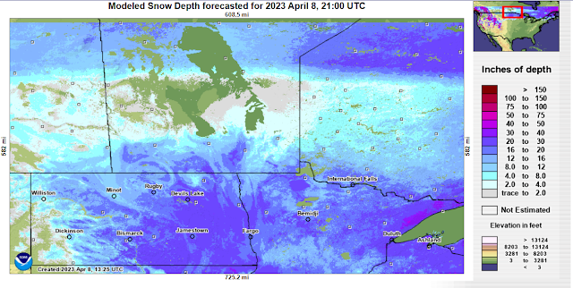
Overnight lows will gradually warm throughout the week with lows staying above zero degrees. There could be days this week where our high temperatures get above the 10C mark, especially on Tuesday-Thursday. The unfortunate thing however is given the fact we still have snow on the ground there is no way to tell how the snowpack will interact with the warmer temperatures, there is a risk that because of the amount of moisture being thrown into the atmosphere fog may become a common occurrence until the snow melts. Why is this?? for those wondering our dewpoint temperatures which I just had a glance at will sit above zero both overnight and during the day time, sitting fairly close to the actual temperatures. This means that the air will not freeze but will allow for liquid to stay in the air as the ground heats up then cools you get these fog patches at lower levels. That could hinder our day time high temperatures if fog develops. However either way you put it there will be a significant risk for flooding as the snow pack diminshes. The following graphics give you an idea of how much snow is left to melt.


No comments:
Post a Comment
Thank's for commenting on the blog, I appreciate it...