Friday, February 11, 2022

Cold Weather For Weekend

 Much of southern Manitoba has been through a period of warm weather,, and a unsettled weather pattern. This pattern looks to shift. A large area of arctic high pressure will move into our area, bringing with it cool and calm conditions. 


On the day Saturday mostly cloudy skies are likely in the afternoon temperatures in the mid to high minus teens are likely across the region (-15 to -20C), This airmass will contribute to temperatures in the mid to high minus teens (-15C to —19C), and temperatures in the low to mid minus 20’s in the southeast with the warmer temps in the southwest on Saturday. Windchill values in the upper minus teens are likely (-18 to -20C) in the southwest, and western Manitoba, areas in the south central and south east will see a decent chance at windchills in the low to mid minus twenties (-20 to -26C). 

Saturday night a large area of the region will see clear skies but increasing cloud by morning and will probably encounter temperatures in the upper minus teens in the southwest (-15 to -18C), with areas in the south central and southeast seeing the low minus 20’s to mid minus 20’s (-20 to -26C). Windchills in southern sections of Manitoba will exceed the high minus twenties in the SW (-27 to -30C) and low minus thirties in the SE (-30 to -36C). The worst of the cold will hit the south central and south eastern half of Manitoba. 

Sunday: An Alberta clipper will move into the region which will bring a swath of snow that will move quickly from west to east, it’s possible that due to the high pressure system off to the south winds will once again contribute to snow and blowing snow, and reduced visibility at times. A quick 3-5cm of snow is possible. Temperatures will also be on the milder side in southwestern Manitoba, where highs in the mid to high minus single digits (-6 to -10C) are likely, with areas in the south central and south east will see highs in the mid to high minus teens (-15 to -18C). Windchill values will only be felt in the Brandon area just to the east into the rest of southern Manitoba except the escarpment ( with values ranging from -15C to -28C). 

Sunday Night: Clearing skies are likely for a large portion of the region, temperatures will drop into the mid to high minus teens with low minus twenties (-16 to -23C) possible in spots. Windchill values will drop into the mid to high minus twenties (-23 to -28C). 

First half of the week: Much of the region can expect high temperatures* and overnight low temperatures in the mid to high minus teens (-10C to -15C)* and overnight lows in the low minus 20’s (-20 to -25C).  There’s a chance at a few clippers moving through our area during the week too, well keep you updated on that  

Monday, February 7, 2022

Milder weather arrives

 This write up will be brief as I don’t have a lot of time, 

Temperatures on Tuesday in Manitoba based on The NAM model. (Above) Seeing highs in the low plus single digits . ❤️❤️. 

Much of southern Manitoba will encounter a period of warmer weather as a mild pacific airmass,, moves into southern sections of Manitoba. Temperatures will rise into the high minus single digits to low plus single digits for daytime highs, with highs on Tuesday surpassing the 0C mark with most regions seeing a chance for rain and snow on the day as well. Snowfall accumulations will mostly sit in the 3-5cm range in the southeast and more around 2-4cm in the southwest. On Tuesday night cloudy skies will clear and cooler temps will filter in with most areas seeing highs in the minus mid to high single digits to low minus teens by morning (-7C to -10C). Temperatures will take a bit of a drop on Wednesday as cool air filters in behind the low pressure system, temperatures will sit in the upper minus single digits and the low minus teens (-6C to -12C). 


Temperatures on Thursday in Manitoba based on The NAM model. (Above) We will be seeing highs in the low plus single digits again as well, but not until the late afternoon early evening hours. 


Wednesday night into Thursday cold air will sit over the area with lows in the mid to high minus teens (-12C to -18C) windchill values might be higher than that with most areas seeing values in the minus 20’s. Thursday will see a return to milder weather thanks to another approaching low pressure system , temperatures during the afternoon will rise in to the low to mid single digits, with a chance at snow, freezing rain and rain. Exact details of this event are uncertain yet , however it appears there will be a initial band of snow , followed by freezing rain and rain. Then overnight into Friday a cold front will swing south making a transition into the mid to high minus teens for lows around (-10 to -15C) and colder with lows closer to minus twenty by morning in some places. 


I hope you have a great rest of your week. Update will be coming in on Friday. -Mike 


Monday, January 31, 2022

Significant winter storm to impact southern Manitoba.

 Much of our region has experienced a lot of winter weather over the past few months, and once again a Alberta clipper will provide significant winter weather conditions that will impact our area. It’s already starting to make it’s presence known as freezing rain has already been swinging through southwestern sections up towards Brandon and Dauphin as it makes its way east. There will be other winter weather impacts, and as a result environment Canada has issued a blizzard warning for this event. Find out when , where and how this winter storm will affect us below. 


(Above) During the afternoon today temperatures will warm into the low plus single digits (1 to 3C) in areas of southwestern Manitoba, whereas areas of the southeast will see highs in the low minus single digits (-1 to -4C) a cold front will move across the region associated with an Alberta clipper system, out ahead of it a band of rain, freezing rain and mixed precipitation or snow will continue to make its way east to the red river valley by evening where it will likely transition over to snow. Temperatures in this area will be cooler than the southwest. 

Tonight (Above): A large swath of heavy snow will sit over the red river valley and eastern Manitoba, this is when the snow may be at its heaviest with snowfall rates as high as 2-5cm an hour during the evening. The cold front will pass shortly after midnight, allowing for a wide swath of snow to move south and east as winds intensify to 70 gusting to 80km/h. Snowfall totals will range between 5-10cm in the southwest to as much as 10-15cm in the southeast. (Snowfall totals map below)

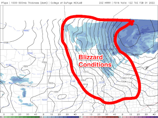
Blizzard conditions are expected to develop in the parklands and western Manitoba before it will move into the Red river valley and eastern Manitoba by the early morning, between 3am and 6am. What this means is that a large portion of our forecast area will see winds at 60km/h consistently with gusts up to 80km/h. Temperatures will also take a nosedive with a majority of the region seeing overnight lows on Monday night dropping into the mid to high minus teens (-12 to -18C), with windchill values in the mid to high minus 20’s (-25 to -29C). 

Tonight: Winnipeg: 60% chance of flurries this evening with risk of freezing rain, snow at times heavy with blowing snow beginning early this evening. Blizzard developing after midnight. Reduced visibilities with near zero visibility at times. Low -13C, windchill -25C. Brandon: Snow. Blizzard developing near midnight. Risk of freezing rain this evening. Snowfall amount 5 cm. Wind south 20 km/h becoming west 20 early this evening then northwest 40 gusting to 70 near midnight. Low minus 16. Wind chill minus 29 overnight. Risk of frostbite. Dauphin: Snow. Blizzard developing near midnight. Snowfall amount 5 to 10 cm. Wind becoming north 20 km/h early this evening then increasing to 40 gusting to 70 near midnight. Low minus 16. Wind chill minus 10 this evening and minus 29 overnight. Risk of frostbite.


Tuesday: As the low pressure system exits the province on the backside of the system strong northwesterly winds will continue with winds gusting as high as 80-90km/h. Blizzard conditions will continue into the afternoon, with conditions improving from west to east by late afternoon into the evening hours. Regardless I’m expecting the heavy cloudcover that’s part of the system will also move east throughout the day from around morning in the extreme southwest to around lunch time by Brandon, clearing in the early evening in the red river valley and southeastern Manitoba by the evening hours.

Temperatures on Tuesday will take a nosedive with a large portion of the south seeing temperatures in the high minus teens and the low minus twenties with the coldest of the weather in the southwest. Expect (-18 to -22C), windchills will exceed the high minus twenties and the low minus 30’s (-29C to -34C). Outlook: Winnipeg: Blizzard ending near noon then snow and blowing snow. Wind northwest 60 km/h gusting to 80 diminishing to 40 gusting to 60 near noon. Temperature falling to minus 20 in the afternoon. Wind chill near minus 33. Risk of frostbite. Brandon: Blizzard ending in the morning then mainly cloudy with 60 percent chance of light snow. Blowing snow late in the morning and early afternoon. Wind northwest 40 km/h gusting to 60. Temperature falling to minus 19 in the afternoon. Wind chill near minus 30. Risk of frostbite. UV index 1 or low. Dauphin: Cloudy with 60 percent chance of blizzard early in the morning then 60 percent chance of snow late in the morning then a mix of sun and cloud. Blowing snow late in the morning and early afternoon. Wind north 40 km/h gusting to 70 becoming northwest 20 gusting to 40 in the afternoon. Temperature falling to minus 20 in the afternoon. Wind chill near minus 31. Risk of frostbite.


Tuesday night: Clear skies will allow for a massive drop in temperatures (not literally but it’ll feel like someone flipped a switch and turned on the freezer full blast. Thanks Jack Frost 🀣🀣.), our overnight lows will drop well into the high minus twenties and low minus 30’s (-27 to -30C), with our windchills seeing the high minus thirties and low minus forties (-37C to -42C, or -44C). Extreme cold warnings might be issued as well because of this possibility. WinnipegClearing in the evening. Wind northwest 20 km/h gusting to 40 becoming light overnight. Low minus 30. Wind chill minus 30 in the evening and minus 39 overnight. Risk of frostbite. Brandon: A few clouds. Wind northwest 20 km/h becoming light overnight. Low minus 28. Wind chill minus 29 in the evening and minus 39 overnight. Risk of frostbite. Dauphin: Partly cloudy. Wind northwest 20 km/h becoming light in the evening. Low minus 25. Wind chill minus 29 in the evening and minus 35 overnight. Risk of frostbite.

Wednesday and Wednesday Night: Much of the region will be under the presence of arctic high pressure which will allow for sunny skies and cold temperatures which will continue to stick around. Temperatures will stick in the low to mid minus twenties (-20 to -25C), windchills will likely sit in the low to mid minus thirties for the day (-32 to -36C). Wednesday night will offer much of the same, overnight lows will plummet well into the mid to high minus thirties (-35 to -39C), a likelihood that our windchills will see a return to the low minus forties and low minus fifties, yes you read that . -50S. There is a chance a few locales near Brandon and Dauphin could surpass minus 50C windchill. Thanks Jack Frost πŸ₯ΆπŸ˜©πŸ˜©. WinnipegSunny. High minus 21. Night:  Clear. Low minus 33. BrandonSunny. High minus 20. Night:  Clear. Low minus 37. DauphinSunny. High minus 19. Night:  Clear. Low minus 31


A full update on the second half of the week will come on Thursday. -Mike McGregor


Wednesday, January 26, 2022

Brief warmup followed by risk of extreme cold ☹️☹️

 It appears southern Manitoba may be in for a very brief but extremely warm period of weather over the next 24 hours, you can thank this change to a warm front moving through in the morning hours as a low pressure system moves into the region. This system unfortunately will bring in another round of unsettled weather before colder weather returns behind it. (I’ll be going back to forecasting individual cities in the province by the weekend. (Including Winnipeg Brandon and Dauphin.) Read on to find out about your outlook for the second half of the week 😊. 


Above: The CMC model , showing the 2M temperature anomaly for the day Wednesday. Temperatures will be well above there seasonal averages with some places being as warm as 8 to 12C above  normal. This trend will be short lived however. 

 Today: Much of southern Manitoba can expect cloudy to partly cloudy skies as a we are in the warm sector of a low pressure system moving through southern sections of Manitoba, by mid afternoon a swath of snow should be setting itself up over the region. It will however be a brief but quick period of snowfall,, only about 3-5cm of snow can be expected across the southern half of Manitoba. Temperatures this afternoon will soar into the low minus single digits with some areas along and south of the trans Canada highway seeing highs in the low plus single digits between 0 and 3C. Tonight: A cold front will begin to cut through the region by the early evening hours, bringing in a chance of some flurries and a risk of blowing snow. Afterwards clearing skies will allow for temperatures will drop drastically, with overnight lows plummeting into the high minus teens (-15 to -20C) and windchills in the high minus twenties (-25 to -30C). 

Thursday: Expect one of the nicer days of the week, sunny skies and partly cloudy conditions in the presence of a arctic high pressure system will bring high temperatures back into the mid to high minus teens (-15 to -19C),, with windchills in the low to mid minus twenties (-20 to -25C). By Thursday night a large swath of the region will see more cloud roll in ahead of another warm front temperatures in the high minus teens to low minus 20’s (-17C to -22C) with windchills in the high minus 20’s and low minus 30’s (-26C to -32C). Before temperatures moderate by morning towards the high minus teens (-15 to -19C). 

Friday: Partly cloudy to mostly cloudy skies are likely during the day ahead of a warm front forecast to move closer to the region, cloudy skies are likely in the western half of the region with some sun and cloud in the eastern half of the area. Nothing in the way of precipitation is expected, maybe a slight chance of flurries for those in the west. Temperatures will sit in the low to mid minus teens (-10 to -16C) in the eastern half of Manitoba and areas in the western half of Manitoba will see highs in the high minus single digits into the low minus teens (-8C to -14C). Windchills will sit in the low minus teens to high minus teens across the board (-10 to -18C). Friday Night: Much of the region will see temperatures warm overnight into the mid to high minus single digits (-5 to -10C), with the exception of the eastern half of the south where overnight lows will only warm into the low minus teens (-10 to -13C). That is usually our average daily high temperature, surprisingly enough.

Saturday and Sunday: A brief period of warm weather is expected on Saturday with a chance of flurries forecast, with highs in the mid to high minus single digits (-5 to -9C). Overnight lows on Saturday will drop again for the southeast and south central with lows in the mid to high minus double digits (-15 to -19C). In the west overnight lows will stay in the mid to high minus single digits (-5 to -10C). Sunday will be a beautiful day with highs once again in the mid to high minus single digits across the south (-4 to -8C). Overnight Sunday expect low temperatures not to budge much as cloudy skies will linger and provide that ingredient to keep the warmth at ground level . Overnight lows will drop into the low minus teens in the pembina valley (-10 to -15C), and areas in the southeast seeing lows in the high minus single digits (-5C to -8C) with areas in the southwest seeing highs in the high minus single digits and low minus teens -8 to -12C). 


Enjoy the rest of your week 

-Mike McGregor

Thursday, January 20, 2022

Brief Warm up brings Blowing snow Risk

 This blog will not be your usual blog post , I’ll have a brief summary of the warnings issued for snow and blowing snow that will be accompanied by warm temperatures. As I have been feeling a bit under the weather lately with my mental health. 

Warm weather arriving, for tomorrow during the afternoon as we enter the warm sector where temperatures might surpass the 0C mark in some areas (Above). 

Much of southern sections of Manitoba is expected to see a brief but very warm period of weather, as a clipper system swings through which will bring the influence of the chinook that went across the Canadian prairie provinces. Temperatures will soar into the low to mid minus single digits with some areas getting as warm as the freezing mark or slightly above zero . 

Extreme cold weather arriving again for the weekend. (Above). 

There also appears that there will be a another surge of arctic air for the weekend, with calm weather but there will be a high risk for frostbite given that windchills will approach or even surpass -40C. As for the snow and blowing snow situation this is what Environment Canada put out for a blowing snow advisory: 


Blowing snow advisory in effect for:


  • City of Winnipeg
  • R.M. of Cartier incl. Elie St. Eustache and Springstein
  • R.M. of Dufferin incl. Carman Roseisle and Homewood
  • R.M. of Grey incl. St. Claude Elm Creek and Fannystelle
  • R.M. of Headingley
  • R.M. of Macdonald incl. Brunkild Starbuck and La Salle
  • R.M. of Portage la Prairie incl. St. Ambroise
  • R.M. of St. FranΓ§ois Xavier
  • Cartwright-Roblin Mun. incl. Mather
  • Mun. of Killarney-Turtle Mountain
  • Mun. of Lorne incl. Notre Dame and Swan Lake
  • Mun. of Louise incl. Pilot Mound and Crystal City
  • Mun. of Pembina incl. Manitou La RiviΓ¨re and Snowflake
  • R.M. of Argyle incl. Baldur Glenora and Greenway
  • R.M. of Prairie Lakes incl. Margaret Ninette and Belmont
  • Mun. of Rhineland incl. Altona Plum Coulee and Gretna
  • R.M. of Montcalm incl. St. Jean Baptiste
  • R.M. of Morris incl. Rosenort and Aubigny
  • R.M. of Roland incl. Jordan and Myrtle
  • R.M. of Stanley incl. Winkler and Morden
  • R.M. of Thompson incl. Miami Rosebank and Deerwood
  • Mun. of Emerson-Franklin incl. Roseau River
  • R.M. of De Salaberry incl. St-Pierre-Jolys and St. Malo
  • R.M. of Hanover incl. Steinbach Niverville and Grunthal
  • R.M. of La Broquerie incl. Marchand
  • R.M. of Ritchot incl. St. Adolphe and Ste. Agathe
  • R.M. of Ste. Anne incl. Richer
  • R.M. of Stuartburn incl. Zhoda Vita and Sundown
  • R.M. of Tache incl. Lorette Ste-GeneviΓ¨ve and Landmark

“Poor visibility in snow and blowing snow is expected or occurring in some locations.

An approaching trough of low pressure will result in increasing southerly winds late this evening into the overnight hours.

Winds will strengthen to 50 km/h with gusts to 70 km/h overnight tonight into Friday morning. These strong winds will cause reduced visibilities in blowing snow, especially in open areas overnight tonight into Friday morning. In addition, snow will begin falling by Friday morning, which will aid in reducing visibilities.

Southerly winds will ease by mid day with the passing of the trough but will quickly switch to northwesterly by late afternoon, which may cause further reductions to visibility on Friday evening.

Overall, 4 to 8 cm of new snow is forecast. An inverse temperature trend will also accompany the approaching trough, as temperatures will rise steadily tonight, reaching the mid minus teens overnight followed by falling temperatures tomorrow afternoon.

Travel is expected to be hazardous due to reduced visibility in some locations. Visibility may be significantly and suddenly reduced to near zero. Be prepared to adjust your driving with changing road conditions.

Blowing snow advisories are issued when winds are expected to create blowing snow giving poor visibility to 800 metres or less for at least 3 hours.

Please continue to monitor alerts and forecasts issued by Environment Canada. To report severe weather, send an email to MBstorm@ec.gc.ca or tweet reports using #MBStorm.“


  After the snow moves through much of southern Manitoba will again experience highs between -15C and -29C with windchills between -25C and -35C with overnight temperatures in the high minus 20’s and low minus 30’s windchills of -43C or more. Please dress warm and stay inside if you can . 

-Mike McGregor 

Monday, January 17, 2022

Winter Storm and blizzard conditions to usher in arctic air for the middle of the week

 Much of southern Manitoba will encounter some very unsettled weather over the next 48 hours or so, a low pressure system moves in from Alberta and impacts the eastern prairie provinces. The low currently sitting at 998MB will spread a large area of snow out ahead of it, which will inevitably create hazardous weather and driving conditions that is expected through Tuesday. This low will also usher in colder temperatures behind it, read more to find out what conditions are expected, when the snow will end and what temperatures we can expect after the storm.


A glance at snowfall totals for the southern half and central regions of Manitoba. Heavier amounts will likely miss the south. Much of southern Manitoba is in store for a significant winter storm as a result of a Alberta clipper moving into the area, this system will result in significant winter weather hazards. One of them being snow and blowing snow. Snow has already started in areas of western Manitoba and it will make its way east through the overnight period, the heaviest of the snow will setup in a line from Dauphin all the way through the interlakes region into the Nopiming provincial park areas. According to Justin “Looks like where the low pressure centre is areas north or it stand the best chance at heavy snowfall”, and that low pressure area will move from southwestern Manitoba into North Dakota shortly after midnight when the bulk of the snow moves into the area. Heavy snow will impact a large portion of the province into the central regions. In regards to snowfall amounts this is what we are expecting for totals (Estimations made by Justin):

Brandon - 5-8cm 

Dauphin - 10-15cm

Melita - 2-3cms

Killarney - 3-5cm

Portage la Prairie - 5-10cm

Winnipeg - 10-15cm

Gimli - 10-15cm 

Steinbach - 8-12cm

The heaviest amounts will fall in areas from the parklands regions into the interlakes with lesser amounts in the far south. Highway travel will not be recommended during the night and into Tuesday, Snow and blowing snow will contribute to poor highway travel. Another thing to note is a swath of 10 to 15cm is likely from just south of the Manitoba lakes including Winnipeg all the way east to Brandon, with a swath of 20 to 30cm possible in the interlakes into the Dauphin areas. 5-10cm is also a possibility south of the trans Canada highway. Temperatures during the overnight will stay fairly warm with lows in the high minus single digits (-5 to -10C) in areas along and south of the trans Canada highway with low temperatures in the mid to high minus teens (-12C to -17C) in areas north of the trans Canada mainly where the heaviest of snow is expected to fall.  

Tuesday: Snowfall is expected to continue through the day on Tuesday with lighter snowfall rates expected by the afternoon hours, the only issue is the winds. Winds will begin to increase in speeds from the western half of Manitoba by morning with the tighter gradients moving east into the red river valley by the afternoon. Blizzard conditions are likely in the red river valley by the afternoon with winds gusting upwards of 70 to 80km/h. There is a chance winds could gust up to 90km/h over the Manitoba lakes and downwind of the lakes, as well it may be possible that blizzard like weather occurs in the rest of the south, so please stay tuned to our Facebook page for updates. Regardless travel on roads and highways is not recommended on Tuesday. Highway closures may end up being possible as well. Temperatures will start out mild in the morning from where they were at the values above minus 10C in the south, before cold air filters in south during the afternoon. Temperatures will drop down to the mid to high minus teens (-14C to -19C), with windchill values in the mid to high minus 20’s possible. 

Tuesday Night: Possible blizzard conditions may continue through the evening, before clearing during the overnight period. It will signal the end to the snowstorm, unfortunately brittle cold will filter in. Temperatures will drop into the low minus 20’s (-20 to -25C) in the southeast with lows in the high minus 20’s in the southwest (-25 to -30C). Windchills in the mid minus 30’s in the east and the -40C range in the west. 

Wednesday: Will end up being one of the coldest days of the week, high temperatures will only end up warming up to the low minus 20’s (-20 to -25C), windchills will sit in the low to mid minus 30’s. Yikes!!! Much of the same is expected for the second half of the week. 


The next blog is scheduled for Friday . -Mike McGregor πŸ™πŸ˜ŠπŸ˜Š. 

Monday, January 10, 2022

Warm Weather Arrives Finally!

 Much of southern sections of Manitoba has been through a deep freeze,, as a result of a constant area of arctic high pressure or what we call a polar vortex. 

There is good news , there is signs that this pattern will start to break down during the next 24 hours as a westerly flow allows warm air from out west to move in. Temperatures will soar into the low to mid minus single digits over the next few days , with some areas possibly seeing highs above the zero degree mark in areas of southwestern Manitoba. There is a chance at some flurries as well on the day Wednesday. Overnight low temperatures will likely also sit over the mid minus teens, daytime high temperatures will plummet again on Thursday with highs in the low to minus teens possible again and overnight lows in the mid to high minus teens. There is a chance that by Friday our temperatures will moderate to more normal values, with highs in the low minus teens. Friday night will see lows in the mid to high minus teens and the low 20’s. This slightly warmer than normal pattern will continue into the weekend with the chance of more unsettled weather . 

-Mike McGregor

Featured Post

Unsettled weather returns to Manitoba, severe weather risk returns

 Southern sections of Manitoba will be seeing a return to wetter than average conditions with the possibility of severe thunderstorms thanks...