Saturday, June 12, 2021

Blog Will Be Updated Soon

 After getting over COVID and recovering I feel as though I can start writing weather blogs again. The next blog will be written on Sunday afternoon for the beginning of the week. I may not do day to day forecasts for the Dauphin region I’m looking at using environment Canada forecasts if need be . I look forward to seeing you all again this week!!! 


-Mike McGregor

Friday, May 7, 2021

Cooler than Average weather continues

 Southern Manitoba and much of the region can expect a cooler than average weekend,, a persistent and stubborn arctic high pressure system will continue to draw in a northerly to northwesterly flow. Normally this time of the year we should be seeing a much warmer pattern. Is there any hope on the horizon, we’ll have a look and see if this temperature trend has any chance of ending anytime soon. 


An area of high pressure will move off into Ontario by Sunday evening. Should help to finally bring in a southerly flow. 

Friday: Much of southern Manitoba will be in the presence of sunny skies on Friday; a northwesterly flow aloft will inhibit temperatures from soaring to our normal day time high temperatures. All of southern sections of Manitoba will see highs in the low teens (10 to 14C), with temperatures over the lakes seeing low to mid single digits (3 to 7C). Heading into Friday night, a calm night is expected some light cloud is expected in areas of southwestern Manitoba however. Temperatures will drop into the low minus single digits (-1 to -3C) in areas of southwestern Manitoba with areas in the southeast staying at the 0C mark. Friday,, Winnipeg: Sunny high 12C. Brandon: Sunny High 12C. Dauphin: Sunny high 11C. Friday Night: Winnipeg: Clear . Low 1C. Brandon: Partly cloudy. Low 0C. Dauphin: Clear low -1C. 

Saturday: During the day Saturday a system with rain and snow will cross from south central Saskatchewan into North Dakota no rain will fall however, there appears that there might be some broken to partly cloudy skies for areas of extreme southwestern Manitoba. The extent of it should only travel as Far East as portage la prairie. Temperatures for the afternoon will rise into the low teens once again (10 to 14C) with the exception of the parklands where highs will stay in the high single digits (7 to 9C). Saturday Night much of the cloudcover that which was in the southwest will clear out and once again I’m honestly not a huge fan of these overnight lows they will drop below zero (-1 to -4C) for areas of the inter lakes and southwestern Manitoba, with the southeast staying above zero, (1 to 3C). Saturday. Winnipeg: Partly cloudy. High 11C. Brandon: Cloudy in the early afternoon, becoming partly cloudy late in the afternoon. High 11C. Dauphin: Sunny high 9C. Saturday Night: Winnipeg: Clear, low 1C. Brandon: Partly Cloudy, low 0C. Dauphin: Clear, low -1C. 

Sunday: Much of southern Manitoba will likely see similar conditions to Saturday, the area of high pressure that will be off in northern Manitoba will start moving south and east this will ultimately allow a northerly flow to take place. Im expecting some off and on clouds throughout the day. Temperatures for some areas of the inter lakes , eastern, and parklands regions of Manitoba will only sit around 10C (9-10C).  Elsewhere for the rest of the south expect high temperatures to rise into the low teens (10 to 12C). Heading into Sunday night I’m finally expecting that pesky high pressure system off in the north that’s been keeping our temperatures cool to finally move over our region into Monday morning. I expect clear skies overnight with partly cloudy skies by morning in the interlakes. Our overnight lows will drop below zero for the Manitoba lakes into the red river valley. (0 to -3C). Elsewhere overnight lows will drop from (1 to 2C). Sunday: Winnipeg: Sunny, high 10C. Brandon: Partly cloudy in the morning then Sunny. High 11C. Dauphin: Sunny high 9C. Sunday night: Winnipeg, clear low 0C. Brandon: Clear, low -1C. Dauphin. Clear low 0C. 

Heading into next week it appears that the area of high pressure that was causing our cooler than normal temperatures will move east into Ontario and the north eastern United States, this will ultimately give us a southerly flow with temperatures returning to seasonal values highs in the high teens to low 20’s, and overnight lows in the mid to high single digits. This would bring along a possibility of us seeing more low pressure systems with a chance that will bring us much-needed precipitation. It’s still a ways out but model trends need to start being a bit more consistent with this, in order for us to have more confidence. Hoping and praying we get that well needed moisture. 

Monday, May 3, 2021

Below Seasonal week ahead

 Southern Manitoba will once again be in a fairly seasonal pattern with a northwesterly flow in place, fortunately high pressure will also be in place allowing for calm conditions. This area of high pressure will be fairly stationary and will not move much over the coming week. Read on to find out how this will impact our temperature pattern, below.


Monday: Much of southern sections of Manitoba can expect calm conditions on the day Monday, mostly  cloudy to partly cloudy skies are expected with some areas south of lake Manitoba seeing some sun mixing in during the afternoon hours. Temperatures will only rise into the mid to high single digits (4 to 9C) on Monday with sections of the interlakes only rising into the mid single digits. (3 to 5C).  Heading into the overnight into Tuesday temperatures will take a nosedive as persistent northwesterly winds kick in, overnight. Clear skies will allow for overnight lows to drop into the low minus single digits (-1 to -3C). With some places even dropping into the mid minus single digits , with lows in the low single digits (0 to 3C)in western Manitoba around by Brandon east southeast into the pilot mound areas as well as Dauphin. 

Monday: Winnipeg: Mainly cloudy. High: 9C. Brandon: Mainly Cloudy: High 8C. Dauphin: Mainly cloudy. High 8C. Monday Night: Winnipeg: Clear, low 0C. Brandon: Clear, low 1C. Dauphin: Clear, low 1C. 

Tuesday: High pressure looks to be in place for the day on Tuesday with a consistent northwesterly flow in place some areas of cloudcover, in the interlakes region and into some sections of the south.Temperatures will rise into the mid to high single digits (5 to 9C) with areas in southern sections reaching the low teens (5 to 10C). Heading into Tuesday night not much in the way will change with the weather, clear skies along with a cool northwest wind will once again allow temperatures to drop below zero (-1 to -4C) with some patchy sections in the southeast and southwest staying above zero. 

Tuesday: Winnipeg: Partly cloudy. High 9C. Brandon: A mix of sun and cloud, high 10C. Dauphin: Partly cloudy. High 9C. Tuesday Night: Winnipeg: Clear 0C. Brandon: Mainly clear, low 1C. Dauphin: Mainly Clear low 1C. 

Wednesday: A large area of high pressure will sit over the prairie provinces on Wednesday which will eventually dive south over Manitoba into North Dakota by Wednesday evening. A low pressure system will bring an area of snow to areas of northern North Dakota however the consistent northwesterly flow will keep most of it south the border. Mainly sunny skies are expected however for the day on Wednesday with the possibility of some cloudy periods, as some areas of heavier clouds filter in from the northwest. There could be some thicker clouds in the southeast in the inter lakes, and southeastern Manitoba. Temperatures will rise into the high single digits in southeastern Manitoba and in eastern portions, with a few small localities in western Manitoba (5 to 9C). Areas further west into the southwestern and western half of Manitoba can expect high temperatures in the low teens (10 to 12C). Heading into Wednesday Night, that area of high pressure I mentioned will be south of us in North Dakota, clear skies are expected for the night on Wednesday with an area of heavier cloud expected to move into areas from just west of Brandon east into Winnipeg. Showers are possible for Brandon into the portage la prairie area. Overnight low temperatures will drop a couple of degrees above zero for most. (1 to 6C). 

Wednesday: Winnipeg : Mainly sunny. High 9C. Brandon: Partly Cloudy High 11C. Dauphin: Mainly sunny High 11C. Wednesday Night: Winnipeg: Clear, increasing clouds by morning. Low 3C. Brandon:  Clear, becoming cloudy before morning with 60% chance of showers. Low 4C.  Dauphin: Clear becoming cloudy overnight with 30% chance of showers. Low 3C.

Second half of the week: Calm weather conditions look to continue with high pressure off in the northern prairies. As for the second half of the week, temperatures will rebound with highs reaching the low to mid teens. And overnight lows will sit in the mid to high single digits. 


Wednesday, April 28, 2021

Warm weather continues,

Much of Manitoba has experienced shift to warmer than weather finally thanks to a shift in the jet stream to a westerly flow, which as a result is pushing the Arctic air mass further north. This pattern looks to continue however there appears, to be some unsettled weather on the horizon. Will we get some well needed moisture ?? Read on to find out more . 


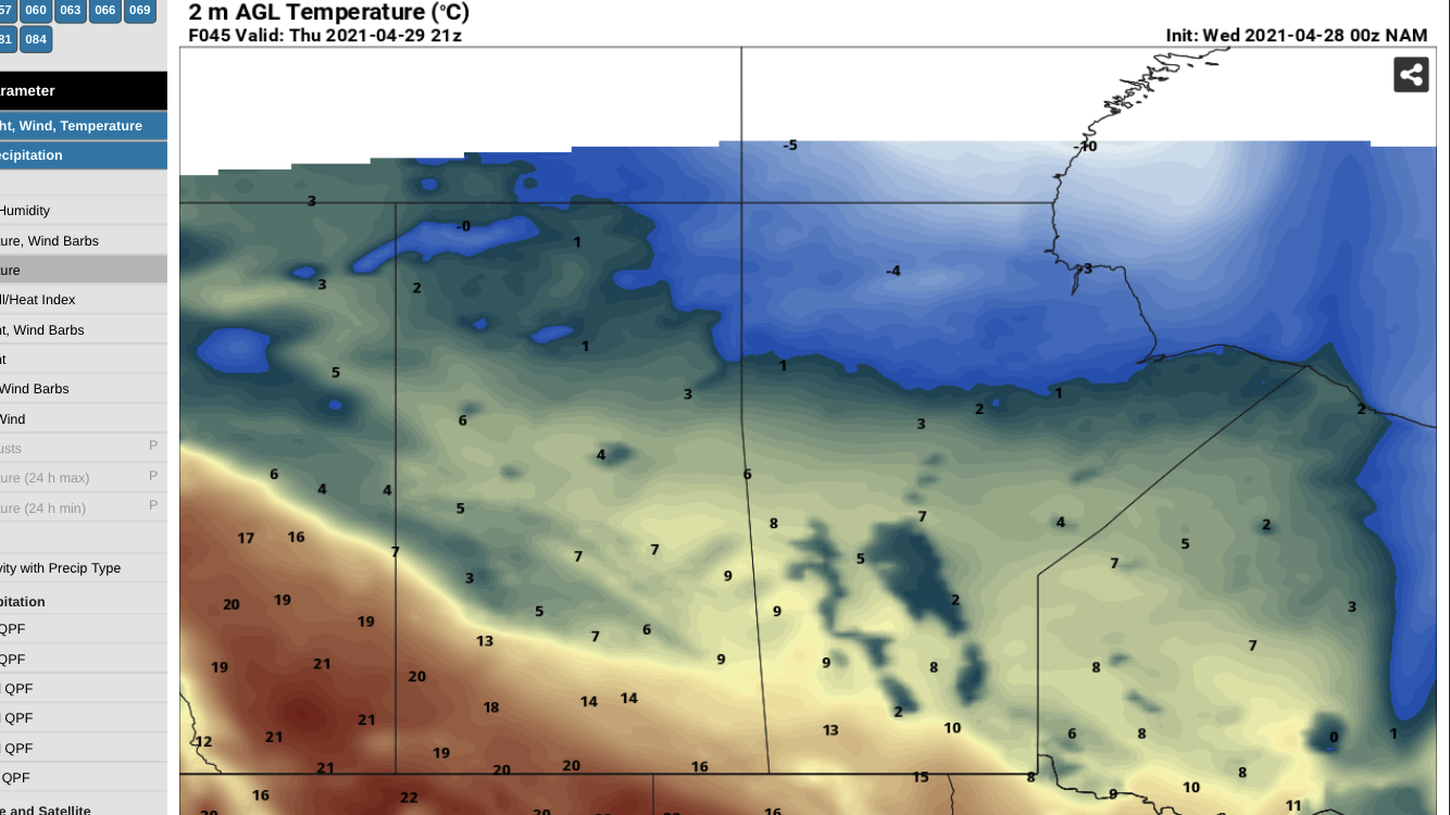
Wednesday: Will start off sunny for most. Then cloudy skies are expected. A cold front and low pressure system will be sliding through the region tomorrow afternoon and evening, this system will be responsible for bringing snow into the parklands, interlake regions in the morning to early afternoon hours. As well this will bring rain to areas south of the Russell region from along a line west to east into Ontario meaning much of southern Manitoba is expecting showers throughout the afternoon into the evening. There is enough CAPE energy for some rumbles of thunder in areas of southeastern Manitoba however I am not expecting any sort of heavy thunderstorm activity. As for temperatures it appears that areas of Southeastern Manitoba will see temperatures in the low to mid teens (10 to 15C).with adjacent areas in Southwestern Manitoba, the interlakes, and central eastern Manitoba seeing temperatures in the mid to high single digits (4 to 9C). Areas along the American border splitting into Winnipeg and  eastern Manitoba by bissett will see temperatures around 10C. Heading into Wednesday night at appears that the system will move off into Ontario behind it a small high pressure system will allow for clearing skies overnight into Thursday with patchy clouds in areas of southwestern Manitoba. Much of Manitoba can expect to see temperatures in the low minus single digits overnight into Thursday, (-1 to -5C). The only portions that will see lows a few degrees above zero (1 to 3C) will be the parklands into the Winnipeggosis area. Forecasts: Winnipeg: Cloudy, 60% chance of showers in the afternoon high 10C. Brandon: Cloudy, 60% chance of showers  in the afternoon high 8C. Dauphin: Cloudy 60% chance of flurries in the morning then 60% chance of showers in the early afternoon high +1C. Wednesday Night: Winnipeg, cloudy 60% chance of showers in the evening, clearing near midnight. Low -1C. Brandon:  Cloudy 60% chance of showers in the evening then clearing low -2C. Dauphin: Clear then cloudy, low 2C. 

Thursday: Much of southern sections of Manitoba including the interlakes will be back into a northwesterly flow thanks to a area of high pressure building in allowing for some partly cloudy to mostly cloudy skies, a slightly cooler temperature trend than on Wednesday also. Temperatures for the day on Thursday will rise into the low to mid teens from areas of southwestern Manitoba into the red river valley and western portions of southeastern Manitoba (10 to 15C). Areas further north of that including the parklands, interlakes and eastern southeastern sections and eastern Manitoba can expect highs in the high single digits (6 to 9C). Heading into Thursday night an area of high pressure will move over the area bringing with it calm weather conditions, increasing cloud is expected as we go into the overnight period. The good news is that our temperatures will remain above zero overnight into Friday (0 to 5C) with lows reaching the low single digits only place where lows below zero will occur is over the Manitoba lakes (0 to -2C). Thursday: Winnipeg: Partly cloudy high 11C. Brandon: Partly cloudy high 12C. Dauphin: Sunny high 9C. Thursday Night: Winnipeg: Clear, increasing clouds before morning. Low 3C. Brandon: Clear, increasing clouds before morning low 4C. Dauphin: Clear, then increasing clouds before morning. Low 4C. 

Friday: A low pressure system riding the border will likely swing through in the morning with a attendant warm front along this heavier cloud is expected to roll in, in the morning as well a brief but heavy swath of rain is expected in the morning into the early and mid afternoon hours in the parklands, interlakes and the eastern sections of Manitoba. The rain should clear the province by late afternoon. A few showers may fall near the Winnipeg region , clearing skies will gradually take place with eastern sections seeing clearing by supper time. Daytime highs will soar into the low 20’s in the southwest (20 to 23C) in a few locations as well as high teens in the parklands and southwestern sections (16 to 19C).  Only low to mid teens are expected in the interlakes, Winnipeg and eastern/southeastern sections (11 to 15C). Overnight into Saturday a ridge will start building and this will be more prevalent on Saturday, clear to partly cloudy skies are expected. Overnight lows for the first time in a long time will match our previous daytime high temperatures and I am talking about the low to high single digits colder as you go further north (2 to 9C), a few sections in the parklands will sit around( 9-10C). A good reason to open your windows I guess !  Friday : Winnipeg: Cloudy then partly cloudy early in the afternoon , 30% chance of showers late in the morning. High 15C. Brandon: Cloudy in the morning clearing in the afternoon. High 23C. Dauphin: Cloudy, 60%chance of showers in the morning then clearing in the afternoon. High 20C. Friday Night: Winnipeg: Partly cloudy, low 6C. Brandon: Partly cloudy low 10C. Dauphin: Partly cloudy low 10C. 

The weekend: It appears that this weekend we will have another low pressure system come in with the chance for showers and or thunderstorms, with temperatures rising into the mid to high teens and low 20’s, overnight lows in the mid to high single digits. It may be a bit cooler for the second half of the weekend however confidence is low . 

Wednesday, April 21, 2021

Warm weather ahead, for a short time. Trough of low pressure to invade the region late week.

 Southern Manitoba will be on the northern end of a area of high pressure over the northern plains, a westerly flow will develop as a result of this system. Warm weather will arrive for the second half of the week the bad news however is this will be short lived, a low pressure system will arrive for the second half of the week. Will it cause us to see rain or snow ??!!! Read on to see what kind of weather we’ll be seeing for the latter half of the week. 


Wednesday Night: Much of southern Manitoba will be under the influence of an area of high-pressure or a weak ridge. The good news is that this will allow for calm weather throughout the overnight. Unfortunately temperatures will drop off into the low minus single digits (-1 to -3C) for a majority of the area with some areas in southwestern Manitoba seeing lows in the low single digits (0 to 2C). Winnipeg: Clear, low -1C. Brandon: Clear, low 0C. Dauphin: Clear low 1C.  

Thursday: An approaching area of low pressure will slide gradually into Manitoba and will be in the region towards the latter half of the day. There is good news however it shouldn’t spoil our chances at seeing a pleasant day weather wise. Sunny skies are expected with our temperatures soaring into the mid to high teens some areas will see highs near or at 20C, for a majority of the southern half of Manitoba (14C to 20C). Cloudy skies are expected in the interlakes and parklands overnight , increasing cloud elsewhere by early morning or sunrise. The action comes in on Thursday night as a trough of low pressure swings into the region, I’m not gonna make people happy with this one but it looks like a short but strong band of snow will be likely heading into the late overnight Thursday. Snow looks to start in the parkland sections of Manitoba by the midnight time frame moving east southeast into the early morning hours reaching portage la prairie or Carberry by sunrise. Accumulations shouldn’t be too much in general varying swaths of 2 to 4cm is possible. Overnight lows on Thursday will drop into the low minus single digits (0 to -5C), with warmer temperatures in the low single digits of (0 to 4C) from Steinbach on southeastwards. Thursday: Winnipeg: Sunny, high 17C. Brandon: Sunny, high 18C. Dauphin: Sunny. high 15C. Thursday Night: Winnipeg: Clear, increasing clouds before morning low 0C. Brandon: Clear , then cloudy after midnight. 60% chance of snow before morning. Low -2C. Dauphin: Cloudy, snow beginning in the evening. Low -5C. 

Friday: A large area of low pressure will swing through on Friday morning with a cold front along with it. It’ll move into Ontario by lunch time.  Mostly cloudy skies are forecast for Friday, snow will move into the Portage la prairie area by sunrise. The Red river valley area by 7am-9am into Ontario by shortly after lunch. Temperatures on Friday will unfortunately not rise that much spotty sections of temperatures a few degrees above zero (1 to 3C) in the interlakes and southwestern Manitoba and southeastern Manitoba including the parklands. From sections of southwest Manitoba, the red river valley and southeastern Manitoba will see swaths of temperatures from -1°C to -3°C. Heading into Friday night there will be clearing skies with much cooler temperatures resulting from this cold front,, overnight lows will sit well below the normal overnight temperature pattern. There is a possibility of seeing lows in the low minus single digits in the parklands and the southwestern sections of Manitoba (-1 to -3C). The mid to high minus single digits for the rest of southern sections of Manitoba (-3 to -7C). Friday:. Winnipeg: Snow in the morning ending early in the afternoon then cloudy, high -1C. Brandon: Snow ending in the morning then cloudy high 1C. Dauphin: 30% chance of flurries in the morning then Cloudy, high 0C. Friday Night: Winnipeg: Clear, low -5C. Brandon; Clear, low -6C. Dauphin: Clear low -3C. 

The weekend: Looks like much of a southern Manitoba will be on the northern end of an area of low pressure temperature is well wildly fluctuates from being in the middle teens on Saturday to the single digits on Sunday. There could also be a chance for some rain and snow late Sunday afternoon and evening into Monday.

Weather Update On The Way

 Hello everyone after a short but well needed break I am back and ready to keep you in the loop with the weather as we head into summer. Only less than 3 months away and we are going to be in storm season. 

I’ll have a post up and ready for you come 2 or 3pm tomorrow afternoon. I’m gonna need some time to work on getting the data, in case you wonder where I get my information from I use https://home.pivotalweather.com/,, https://www.wpc.ncep.noaa.gov/# and https://weather.cod.edu/forecast/# . I’m also implementing more pages as the spring goes on, which will probably end up being satellite data and ground temperature observations. Let me know what you all think of this. May the Lord Jesus richly bless you !!


Tuesday, April 13, 2021

Relaxing and calm weather returns, with a chill in store.

 Much of southern Manitoba has experienced a powerful winter storm which left snowfall totals in the 25 to 30cm range in regions of the interlakes, parklands and western sections of Manitoba. Lesser amounts fell in the south the good news however is that the system which affected us has moved off into Ontario, an area of high pressure off in Alberta will create a northerly flow ahead of it. Read on to Find out how that will affect us.


Above: Much cooler weather conditions expected for the day Wednesday thanks to a recent snowstorm that will be inhibiting temperatures from warming too much. Only sitting in the low single digits or slightly below zero. 

Wednesday: During Wednesday much of southern Manitoba will be enveloped in cloud cover, there will be a potential for periods of snow in the early morning hours. As we get towards the afternoon there is a likelihood of off and on flurries into the evening with the risk of freezing drizzle. The only bad news is that the snow cover that is currently on the ground will inhibit temperatures from rising to above zero or our seasonal normals. Much of the region temperature wise will only warm slightly, with a large section of the parklands and western Manitoba seeing highs below zero (0 to -2C). Areas around that including southeast, southwest and parts of eastern sections of Manitoba will see highs a few degrees above zero (0 to 3C). In the evening to overnight. Any leftover flurries will clear the region, mostly cloudy skies expected for a majority of the night into Thursday. Overnight low temperatures will likely stick in the lower minus single digits, mainly seeing the temperature values between -1°C and -4°C. 

Wednesday: Winnipeg: Mainly cloudy with 30 percent chance of flurries and risk of freezing drizzle. Wind north 30 km/h gusting to 50. High zero. Wind chill minus 11 this morning. UV index 5 or moderate. Brandon: Cloudy with 30 percent chance of flurries and risk of freezing drizzle. Wind north 20 km/h gusting to 40 becoming light this afternoon. High minus 1. Wind chill minus 11 this morning and minus 6 this afternoon. UV index 4 or moderate. Dauphin: Cloudy with 30 percent chance of flurries and risk of freezing drizzle. Wind north 20 km/h becoming light this afternoon. High zero. Wind chill minus 9 this morning. UV index 4 or moderate.

Wednesday Night: Winnipeg: Mainly cloudy with 30 percent chance of flurries. Wind north 30 km/h becoming light this evening. Low minus 4. Wind chill near minus 8. Brandon: Cloudy with 30 percent chance of flurries. Wind north 20 km/h becoming light this evening. Low minus 7. Wind chill minus 12 overnight. Dauphin: Cloudy with 30 percent chance of flurries. Wind up to 15 km/h. Low minus 7. Wind chill minus 6 this evening and minus 12 overnight.

Thursday: Looking ahead to the day Thursday it appears that an area of high pressure will approach the province of Manitoba sitting mainly in Eastern Saskatchewan. Mainly cloudy skies are expected for the day on Thursday there is a possibility for a small swath of snow to move through the western portions of Manitoba and particularly the parklands in the afternoon hours. A trace to 2 cm is possible. Good news for Thursday is that the temperatures will finally rise above freezing for a majority of southern sections, looking at the Data it appears that our temperatures will warm into the low to mid single digits (0 to 5C). This will be beneficial as we are looking to hopefully see the snow melt. Heading into Thursday night it appears there may be a small section and extreme south western Manitoba with a potential for some heavy flurries in the evening hours. Clear skies are possible in south eastern Manitoba with heavier cloud cover in southwestern sections of the province with the chance for spotty showers in the evening. Overnight low temperatures for Southwestern Manitoba May see a few patchy areas where temperatures drop above zero. However a majority of southwestern portions of Manitoba will see overnight lows just below 0°C likely -1 or -2°C. 

Thursday: Winnipeg: A mix of sun and cloud. Wind becoming north 20 km/h in the afternoon. High plus 3. Wind chill minus 8 in the morning. UV index 6 or high. Brandon: Cloudy with 30 percent chance of flurries. Wind up to 15 km/h. High plus 3. Wind chill minus 11 in the morning. UV index 3 or moderate. Dauphin: Cloudy with 30 percent chance of flurries. Wind up to 15 km/h. High plus 3. Wind chill minus 11 in the morning. UV index 3 or moderate.

Thursday Night: Winnipeg: Partly cloudy. Wind north 20 km/h becoming light in the evening. Low minus 6. Wind chill minus 10 overnight. Brandon: Mainly cloudy with 30 percent chance of flurries. Fog patches overnight. Wind up to 15 km/h. Low minus 7. Wind chill minus 11 overnight. Dauphin: Mainly cloudy with 30 percent chance of flurries. Fog patches overnight. Wind up to 15 km/h. Low minus 7. Wind chill minus 11 overnight. 

Friday: Southern Manitoba will continue thanks to the presence of an area of high-pressure which will allow a persistent northern flow allowing for slightly cooler temperatures than average. Cloudy skies are forecasted in extreme Southwestern portions Manitoba which may give some off and on showers in the late morning and afternoon. Sunny skies are expected for the day on Friday with a potential for some cloud cover in extreme Southern portions of Manitoba particularly near the border. Daytime high temperatures for the day on Friday will finally rise into the mid to high Single digits (4 to 7C). The only exception being the Manitoba lakes for temperatures which will likely sit in the low single digits (0 to 3C) thanks to cooler lake temperatures and recent snowfall. Friday night expect mostly clear conditions as a result our temperatures will take a plunge below zero again. Our Temperatures will drop, into the low to mid minus single digits (-1 to -5C), areas over the Manitoba lakes may be closer to -7 or -8°C. Friday: Winnipeg: Sunny. High plus 4. Brandon: Sunny, Clearing. High 8. Dauphin: Clearing. High 8.

Friday Night: Winnipeg: Clear. Low minus 7. Brandon: Clear. Low minus 8. Dauphin: Clear. Low minus 8. 

Into the weekend: We will continue to be on the eastern side of an area of high-pressure in Western Canada, A cold front looks to sweep through the region on Sunday night into Monday with a brief temperature drop likely. Will update you on Friday as the weather models come in.  It appears that the warmest weather will remain stateside with they continue to trend of temperatures remaining in the mid to high single digits for daytime highs and overnight lows in the low to mid minus single digits as well. 


Please note that the forecast numbers I use currently are from environment Canada until I can get a better handle on figuring out temperatures from weather models

Featured Post

Unsettled weather returns to Manitoba, severe weather risk returns

 Southern sections of Manitoba will be seeing a return to wetter than average conditions with the possibility of severe thunderstorms thanks...