A warm and unseasonably above normal air mass will arrive this week, boosting our temperatures up to potentially record breaking values on Tuesday through Wednesday. There will also be another system rolling in on Wednesday-Friday bringing out some unsettled weather. Find out what that means for us.

Tuesday: Will end up being one of the first hottest days of the week, sunny skies and a southerly flow all ahead of an area of low pressure will boost our temperatures well into the high twenties and the low thirties for a large portion of the south (27-34C). The exception will be the interlakes regions, you may only get up to 25C. It’s possible a few areas may see high temperatures above thirty degrees, that’s looking possible in the Dauphin-Assesippi regions as well as extreme southwestern Manitoba and areas along
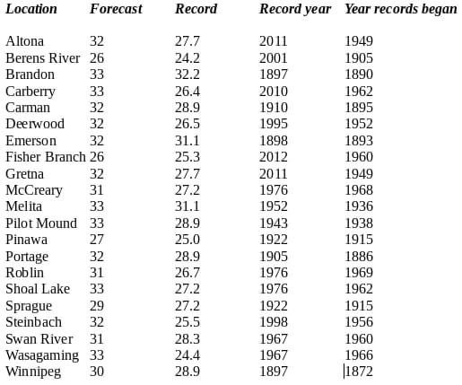
the American border. There’s a chance that records could get broken as well, with a lot of areas seeing high temperatures forecast higher than there previous record Information From @ecccweatherMB on twitter: https://t.co/1pcYXqDTfm Winnipeg: Sunny high 29C. Brandon: Sunny High 33C. Dauphin: Sunny high 31C.
Tuesday Night: Mild air will continue to sit over our area, by morning a warm front should be draped over the eastern half of Manitoba with a cold front sitting over western Manitoba at the SK/MB border. Clear skies are likely over a large section of the province with the exception of the southwest where some scattered clouds are possible overnight. Temperatures will sit around the mid to high teens (14 to 18C), unusually mild for lows as we normally see lows this time of year below 10C or slightly above. Winnipeg: Clear, low 17C. Brandon: Clear, low 16C. Dauphin: Clear, low 15C.
Wednesday: Will end up being one of the last days of the heat, a cold front will advance into the southern sections of Manitoba during the late afternoon hours. Ahead of it increasing amounts of cloud cover are possible, also increasing amounts of instability are possible during the afternoon and evening mainly in the middle levels of the atmosphere. Anywhere from 800-1,200J/Kg of CAPE (Storm Energy) is possible. There will be a risk for thunderstorms to develop in the late afternoon hours into the early evening period before sunset. The best risk area appears to be in the red river valley into eastern sections of the province. Storms will have a slight chance of becoming severe, if not I’m only expecting they will remain below severe limits on the strong side. The American border just east of Pilot mound through the Winnipeg area north into the interlakes and east to the Manitoba border all the way south to Sandilands , are at risk for storms on Wednesday. There will be a chance for showers in the southwestern half of Manitoba, however it won’t be a washout . Temperatures for the day will soar into the mid to high twenties again; the exception being that the southeast will see the hottest weather where some locations can expect highs to soar into the low thirties. Winnipeg: Sunny, then partly cloudy with 60% chance of showers late in the afternoon, risk of strong thunderstorms late in the afternoon. High 32C. Brandon: Sunny, then partly cloudy with 60% chance of showers. High 21C. Dauphin: Sunny, then partly cloudy with 60% chance of showers. High 22C.
Wednesday Night: It looks as though a cold front will be moving through the eastern sections of Manitoba. The good news is that this will drop our temperatures the unfortunate part of this , is that it will also bring in unsettled weather. There may be some strong thunderstorms before sunset, however they will weaken as the sun sets. As the front slowly moves through a large batch of showers and embedded thunderstorms might move through overnight into Thursday if it does so there may be enough rainfall to lessen the drought stricken areas of Manitoba. However consensus shows only 5-15mm max. Temperatures will drop into the low to mid teens overnight. Winnipeg: Cloudy with 60% chance of showers and risk of thunderstorms ⛈. Low 15C. Brandon: Cloudy with 60% chance of showers, early in the evening. 🌧 Low 14C. Dauphin: Partly cloudy with 60% chance of showers in the evening. Then cloudy. Low 10C.


No comments:
Post a Comment
Thank's for commenting on the blog, I appreciate it...