Southern sections of Manitoba can expect a hot and humid weekend ahead, an approaching low pressure system will draw a humid airmass up from the Gulf of Mexico. This system will be the culprit for increasing humidity levels and higher temperatures. The risk for severe weather will also increase. This unsettled pattern is expected to continue into the weekend. Read on to Find out more about the increasing severe weather risk and the heat expected.
Friday Night: Tonight fairly calm conditions are expected ahead of the low pressure system. Winds will be light out of the south to southwest, an area of showers and weak thunderstorms are likely to occur in southwestern Manitoba by early morning. Severe weather however doesn’t look likely. Temperatures tonight will drop into the mid to high teens.
(Above) Severe weather outlook map for the day on Saturday. High risk of severe weather during the day into the evening.
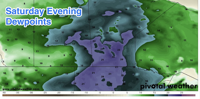
Saturday: This is when the forecast gets interesting, a low pressure system will be moving into southern Manitoba by the later afternoon. Some left over showers will move through in the morning hours with some left over cloud cover. Depending on clearing, sufficient heating may be inhibited. Also this severe weather outlook is conditional. Regardless Increasing humidity will come into the region by the afternoon, with dew points rising into the high teens to low 20’s. Possibility of dew points rising to 25C. Temperatures will rise into the high 20’s to low 30’s, with the hottest of the weather happening in the southwest. Temperatures might rise past 30C in the south central part of Manitoba but that chance is lower. Humidex values will feel close to the mid to high 30’s. The main concern comes later in the day with CAPE (Thunderstorm Energy) from 2,000J/Kg upwards to 4,500J/Kg in areas of western Manitoba by early evening. The potential exists for capping to be in place during the day before a general weakening by mid to late afternoon. An approaching warm front will be the trigger for thunderstorms, and there’s a good chance there will be some isolated severe thunderstorms by the late afternoon and evening. Right now models are all over the place on where they will pop, but if they do they will become severe quite quickly. Environment Canada has southern Manitoba in a moderate to high risk area for severe weather on Saturday. If thunderstorms develop they will likely produce very large hail, damaging winds, frequent lightning, flooding rains and the potential for a tornado or 2. The best threat area for that is in the red river valley, into western Manitoba.
Saturday Night: Any thunderstorms left over on Sunday evening that develop or form will be severe,, heading late into Saturday night and early Sunday morning a complex of thunderstorms will develop in Saskatchewan and or Montana and will likely impact southern Manitoba by the early morning hours. These thunderstorms could be severe it’s all dependant on how much CAPE will be in place by morning. Again I will not know more until later on the day Saturday when models verify. Which is why I will likely update on Manitoba weather centre, during the day. Temperatures on Saturday night will drop into the high teens to low 20’s.
Sunday: Expect possible thunderstorms in the morning hours, then gradual clearing by the afternoon as the cold front moves into northern Ontario. Temperatures will drop significantly with most of the region seeing highs in the high teens and low 20’s. Theres a possibility that if cloud clears out sooner than predicted by the NAM that the area will see highs in the low to mid 20’s. With high 20’s possible in only a few locales.
Sunday Night: An area of showers or thunderstorms may move into southwestern sections of Manitoba with the possibility that extreme southwestern areas of the region may see some strong thunderstorms in the early evening hours. The possibility exists that there will be showers in the south western and south central regions in the morning hours on Monday. Sunday night overnight low temperatures will drop into the mid to high teens.
First half of the week: Showers and thunderstorms look possible to start off the week, with another cold front moving southwards. Calmer weather arrives afterwards as high pressure builds in with cooler temperatures in the low to mid 20’s and overnight lows in the low teens to mid teens. A ridge of high pressure will build in allowing our temperatures to reach the high 20’s by mid week.


No comments:
Post a Comment
Thank's for commenting on the blog, I appreciate it...