Wednesday, March 2, 2016

Seasonal Temperatures Finally Return (Information Compiled by Rob's Blog, A Weather Moment, and Environment Canada.

*No Copyright Intended*

It has been a very cold past couple of days here in Southern Manitoba thanks to a arctic airmass that was in place, that has now cleared out allowing for seasonal temperatures to return. It is a welcome return. However as we approach the weekend our weather could become more active as warmer and more above seasonal air starts moving into our area.


Chance of flurries and sun.
High -5 to -10C
The rest of the day today will offer light winds for most and some cloudy skies and flurries off into the southwestern areas of the Red River Valley into Westman and the riding mountain areas, clearer skies will be in place elsewhere. The flurries are in part due to a system sliding through in North Dakota. High temperatures will be in the mid minus single digits for most with a high of minus five in Brandon, Dauphin will have a high of minus nine. Winnipeg will be closer to minus ten, with a high of minus eight. Bissett and Gimli will be inbetween minus five and minus eight.


Chance of Flurries
Lows -23C to -17C.
Tonight a chance of flurries will linger in areas of Westman, Southwest Red River Valley, and into the Riding Mountain areas. That should clear out by shortly after midnight, low temperatures will dip to minus eighteen in Winnipeg, minus twenty three in Bissett, minus seventeen in Brandon and Dauphin.


Increasing Clouds
High's -4 to -6
Thursday will be a bit of a sunnier of a day as an area of high pressure moves in from the northwest before cloudcover moves in later in the day as an area of low pressure approaches from the west. Winds will be light as well. High temperatures will be a bit warmer with high's instead of being around minus ten they will be closer to minus five. A few places to name Bissett will be sitting at minus six, Brandon at minus four, Winnipeg at minus six, and Dauphin at minus five.

Mainly Cloudy
Lows -12 to -20C

Thursday night should be a bit warmer with cloudcover and lows will only be getting into the mid minus teens and slightly above minus ten, a low of minus nine can be expected in Dauphin, minus eighteen in Gimli, minus twelve in Brandon, minus twenty in Bissett. Minus thirteen in Winnipeg.


Snow on the way for the day Friday, not much expected though. 2 to 4cm at least.


Snow Amount 2 to 4cm,
except for Northern regions.
Highs -1 to -6C.
Friday will be a different story an area of low pressure will move through areas of southern Manitoba through the morning to late afternoon and early evening, it will bring a swath of snow with it that will clear out by shortly after supper time. The bulk of it should fall before the noon hour. Amounts should be fairly light with about to 2 to 4cm expected. Areas in the northern interlake and towards Bissett will miss the snowfall, and will experience cloudy skies. Environment Canada is forecasting flurries for now, but I think that the light to moderate snowfall would be a better bet.
High temperatures will be in the mid minus single digits, Winnipeg about minus five celcius, Brandon about minus one, Dauphin minus six, Gimli minus one, and Bissett minus six.

Long Range: Mild Weather Returns As Predicted

Long Range models are continuing to show mild weather on the way for all of southern Manitoba into eastern Canada. There is barely any signs of a cooldown in the near future either.


850mb temperature anomaly Sunday March 6th


850MB Temperature Anomaly Tuesday March 8th


850MB Temperature Anomaly Wed March 9th
850MB Temperature Anomaly Thur March 10th
 
NAEFS 8 to 14 day outlook, showing above seasonal temperatures sticking around
 
 As I have been talking about all this time above seasonal weather is expected as their appears to be a major pattern shift on the way. The arctic airmass that was in place for weeks will finally move out of the area and won't come back anytime soon.  A ridge collapsing out on the west coast will allow for a more zonal flow to take place allowing for pacific air to rush in, as a result much of the country will benefit from warmer air. The pattern shift was also mentioned on TheWeatherChannel in the states.
As a result we will see temperatures above normal for this time of year, with high temperatures around zero to even above freezing through the weekend into next week. We may see a few days of temperatures below zero, but for the most part above zero. High temperatures at times may even approach ten degrees, yes you heard that right plus ten. Along with the warm March sun and highs above freezing our snowpack should quickly diminish. Normal high temperatures are now inbetween -5 and -10C, normal lows between -10C and -20C. Winnipeg's normal is now high -5C and Low -15C.

  Increased Precipitation Chances

Potential for rain on Monday Night,
with lows above freezing.
If you are interested the Jetstream will favour a trough on the west coast which will divert the stormtrack further south into California where the rain is desperately needed. The zonal flow in our country will also allow for an increased chances of rain and snow as the stormtrack is lined up straight west to east through us. In fact we may see some rainfall on Monday night changing over to snow on Tuesday but it should melt, it will be a stronger system that we haven't seen in a long time, but it will be something to watch for. Stay tuned for updates!

Monday, February 29, 2016

Could this be the last cold blast of Winter? Information Provided by A Weather Moment

This week could very well be the last and final blow of winter as we experience another week of below normal temperatures, but it appears that spring may be around the corner.

At the moment we have about 107cm of snow on the ground and it is the 8th warmest winter in history according to robsobsblog.blogspot.com. Read the full article here... http://robsobsblog.blogspot.ca/2016/02/cold-end-to-mild-winter-warmer-weather.html

 Tuesday will be a bit warmer than that of Monday which in fact was our coldest day of the week. High temperatures on the day Monday were in the minus twenties with windchills in the minus thirties near minus 40C. Why? Thank's to the arctic cold front that slipped through Sunday evening, that was responsible for bringing the blizzard like conditions that made for near zero visibilities in blowing snow. Luckily it didn't stay long. 

 
 Warmth out west waiting to expand further east, although the arctic airmass is continuing to hold it back.
Expect the warmth to gradually move east.


Tuesday will be a bit warmer with highs in the low minus teens, along with windchills near minus twenty. Skies will remain clear with arctic high pressure nearby off to the north, unfortunately that will be keeping our warm temperatures at bay until it clears out. Winds will be light out of the west as well with the main warm temperatures staying west of us.


Wednesday will be a similar day to Tuesday, except there will be winds out of the north rather than the west, clear to partly cloudy skies will be in place with high temperatures in the low minus teens near minus ten.
 
2M Temperature Anomaly March 6th to 11th
 
 
500MB Height Anomaly March 8th to 13th 
 
 
Snowcover February 28th
Here Is The Good News: Spring Weather Likely Next Week and Beyond
 
The long range is looking promising, various weather models are coming into strong agreement on warmer weather (above seasonal temperatures) arriving from the west starting this weekend, I double checked and I am not dreaming or am I making this up. Once the ridging out west comes into the province snow will likely melt quite quickly as there is a likelihood of temperatures surpassing the freezing mark we may even see days of near plus ten degrees. Given that there is a lack of snow cover out west and south of us including extreme southwestern Manitoba, there will likely be a very fast transition to spring weather. The warmth looks to persist into the Spring Equinox. If you don't believe me you can have a look at the weather models yourself at michaelmcgregor7.wix.com/southmbwxcentral.


Wednesday, February 24, 2016

Warm Week Continues, Cold or Snow For The Weekend! Information provided by A Weather Moment

It will continue to be a warm week this week as mild air from the pacific continues filtering in, before we arrive in another coldsnap to start the weekend into next week. Highs getting 3 to 6C above average before the coldsnap arrives. As tough as the weather may sound it will not be a long coldsnap at all.

For the night ahead expect clear skies as a cold front slumps southwards with winds blowing from the north. Overnight lows expected at and slightly below minus ten for most people in the south.

Thursday will be a bit cooler with a weak ridge of high pressure moving in behind the cold front that passed through on Wednesday night, high temperatures around and slightly below minus five expected through the day on Thursday. A high of minus six can be expected in Winnipeg on
Thursday. There is a chance of flurries during the day but expect that to clear out by the evening timeframe for the region.

Friday will be the warmest day of the week as temperatures soar with the Jetstream sitting off to the North


Friday will be the warmest day of the week as an area of low pressure enters the central Manitoba region bumping our high temperatures as light westerly winds take hold. High temperatures expected around the freezing mark in the southeastern half of the province including the red river valley, but getting slightly above freezing for the Westman and Dauphin regions up towards the Swan River and Saskatchewan border. A cold front will slump southwards during the evenin bringing a chance for flurries and snowfall, winds will shift to the north around 30km/h. Temperatures will unfortunately dip down to near the minus ten mark overnight.

Long Range: Potentially Cold and Unsettled

Looking ahead in the long range various models have differing ideas on the way a low pressure system may track. Temperatures may stay cool and the weather may be clear if the system stays south, or it may possibly travel through the area, bringing with it seasonable temperatures and some snow. It all depends on how the system travels. At this moment though based on what I'm seeing from the NAM model (the most accurate short range model) it looks like the system will travel through our area and give us snowfall. That would favour warm temperatures for us but I will keep you all updated on this on Twitter.


Warmth returns March 2nd, 850MB Temps show that on this ECMWF model run.

Potentially Above Seasonal For The Start Of The Week


Looking ahead to next week if we see a cooldown and the system does not go through our area our temperatures will quickly switch from below seasonal to near and above average based on the latest ECWF run. It also agrees on Brett Anderson's weather outlook with mild to above average temperatures. Keep in mind our average daytime high is about -6C so if we see above average temperatures we will probably be around zero to even above zero at times. Our weather may end up being variable though if this ridge that is out west doesn't move east, and we remain in a northwestern flow providing periods of warmth and cold with numerous low pressure systems sliding through. I do agree more on a above seasonal temperature trend though. Spring is definitely on the way!


Information provided by A Weather Moment, Brett Anderson of AccuWeather and Environment Canada Weather

Monday, February 22, 2016

Week Of Warm Weather Brings Weekend Coldsnap

 
Manitoba will enter a phase of warmer weather this week before we end up in another arctic airmass to start the weekend.


The warm weather and south winds we saw today was in part due to a trough of low pressure that is hovering over our area. Tonight an area of snow will develop as the trough of low pressure moves through, switching our winds to the north by the morning Tuesday.
 
For the day Tuesday "winds will be out of the North at 20 to 30km/h with a few flurries persisting during the day along with cloudy skies" according to Scott from A Weather Moment. Despite having winds out of the north the temperatures will remain mild around the mid minus single digits for most.
 
Wednesday will also be cloudy and mild with clearing conditions later on in the day, highs closer to zero at around -5C to -2C. It will still be a decent day but those who hate grey days it will be one of those. Pacific Air will dominate for the remainder of the week here, while southern ontario deals with a major snowstorm and strong winds out of the north. They are expecting up to 30cm in some areas they can have it, I feel bad for them as winter will stick around longer because of the increased snow cover.
 
 Long Range
 

                                                              Cold Blast to end the Week


                                                   850mb temperature anomaly Feb 29


                                                  850mb Temperature Anomaly Mar 1st


                                                  850MB Temperature Anomaly Mar 2nd


After a week of warmer than normal temperatures we will likely be greeted by another blast of arctic air to start the weekend and by the looks of the ECMWF weather model it may end around the 1st of March to the 3rd of March. Theweathernetwork also latches onto this idea. So it will be very brief as to previous years we would be stuck in it for weeks, thank you El Nino!
 

Thursday, March 26, 2015

Spring Pattern Setting Up


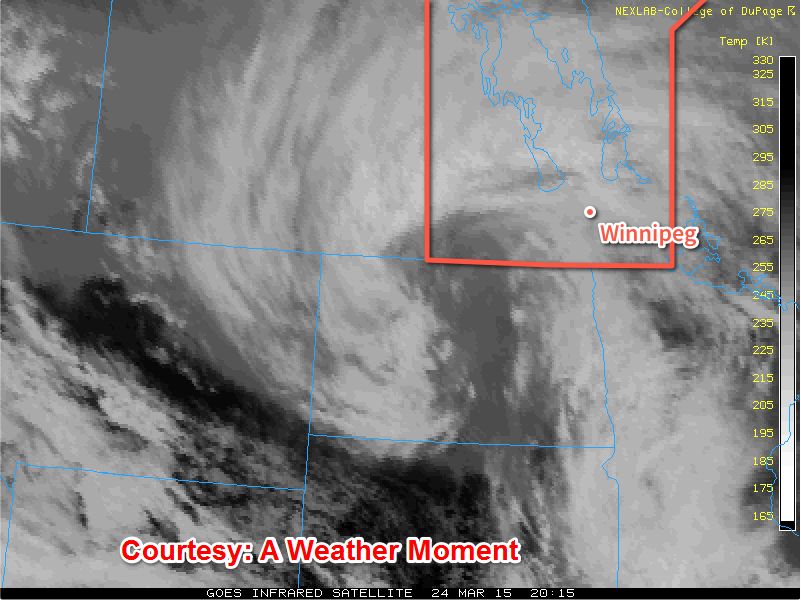
After a period of very warm weather that melted all of our snow last weekend in through the week , the snow came back with a vengence giving southern Manitoba another taste of Winter  despite there being rainfa
ll with the system. During the day on Tuesday through Wednesday, the seasons first most potent storm system came through Southern areas giving regions impressive snowfall totals some areas racking up as much as 25cm. This appears to be the last significant snowfall of the season here in Manitoba, let's hope. (Totals shown below).


The snowfall and gusts of 60-70 km/h making visibilities low and highways very slippery, it was quite bad for motorists who were travelling along highway 75, 59 and Highway 1, 6, 16 and 10. 2 Accidents ocurred, one about 5km east of Elie with 2 semi trailers that collided in a jackknife collison. Also along highway 75 a schoolbus rollover occured by Ste Agathe. There were also several other rollovers that occurred which resulted in highway closures. http://winnipeg.ctvnews.ca/treacherous-road-conditions-lead-to-multiple-manitoba-crashes-1.2296304 
There were also power outages in parts of Winnipeg, on Inkster and out in the Dugald areas. Southern Manitoba for the most part had numerous power outages caused by heavy snow and wind (which caused power poles to ignite). Manitoba Hydro is working on a fix for towns affected. On top of the snow that we recieved we also picked up about 8mm of rain here in the Winnipeg area. So what will our weather look like for the next few days? Let's have a look below.


Thursday: 
The day on thursday will be a fairly cool day with the wind blowing from the Northwest fairly light, although given the strong March sun it may not feel all that bad outside. There probably will be a significant amount of melting given the below zero temperatures that are forecast for the day so it will probably feel nice outside. We cool down a couple degrees past the minus ten mark, overnight. May not all be that bad. 

Mix of Sun and Cloud
-3C / -13C

Friday:
Friday will be a sunny day to start off in the red river valley, until a system slides through our region as flurries move out of southwestern Manitoba. Amounts of 1 to 2cm can be expected in the Winnipeg area. There will be a likely chance they will exit the region by around mid afternoon, any snow that falls will likely melt. High's will still be about 2 or 3 degrees below average in the Winnipeg area.                                                                                                     


Flurries then Sunny
-2C/-12

Saturday Through Monday
Is it is looking like another storm system will be on our doorstep for the day on Saturday and Sunday. It is still quite far out to say anything yet, although given our model trends with past storm events it's quite likely this will turn out to be a event worth talking about.


However latest model runs are showing that it will be warm enough to support a rain event. That will likely be the case considering we are nearing the month of April, the rainy month. So it may be a cloudy and wet weekend with temperatures sitting above zero for the most part. It has been a dissapointment that our weather has not been dry and mild, however as we get further into Spring our weather will certainly get nicer. So with the look of things we are starting to enter a more typical stormy spring pattern, and hopes are that the weather will get a lot better and not stay  gloomy and wet althrough the spring. We aren't in Vancouver after all. :-)

Featured Post

Unsettled weather returns to Manitoba, severe weather risk returns

 Southern sections of Manitoba will be seeing a return to wetter than average conditions with the possibility of severe thunderstorms thanks...