A quick note, I will be updating these blogs with a summary on days that weather is calm or not significant. With days getting hotter in the summer I will be writing more detailed blogs to inform people of the heat and humidity as well as severe weather events that occur. This weeks mid week update is below.
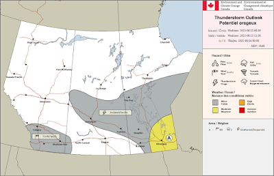
Much of southern Manitoba has seen a below normal temperature pattern over the past few days , the warmer weather did arrive back on Tuesday and that trend looks to continue. There will be a cold front driving through the southern half of Manitoba, a large area of SBCAPE in excess of 800-1000J/Kg will encompass areas of southern Manitoba. A General threat for severe thunderstorms exists for southern sections of Manitoba from 4pm-10pm. A higher chance for severe storms exists in areas of eastern Manitoba, as the cold front kicks up with the heat and humidity in place. Expect. A threat for large hail, heavy rain, and strong winds current model data suggests gusts 80 to 100km/h are possible with thunderstorms. High temperatures are expected to rise into the mid 20’s to low 30’s. Heading into the rest of the week, high temperatures look to sit in the mid to high 20’s, some days may see low 30C values. There will also be a good chance at seeing overnight lows in the mid to high teens as well.
I’ll update this blog, later this week on Friday. -Mike McGregor


No comments:
Post a Comment
Thank's for commenting on the blog, I appreciate it...