Tuesday, October 26, 2021

Unsettled weather makes a return.

 Much of southern Manitoba has been experiencing average temperatures and calm weather over the past week and a half, that trend looks to continue. The only thing is that we can expect some slightly unsettled weather and possibly a tad colder weather. Read on to Find out what we can expect weather wise and how cold things will get. 


(Above: Rain is expected for the day on Wednesday into Thursday. Amounts will vary, it won’t be a wash out but in general I’m only expecting 5-10mm maybe even 15mm in sections of the white shell)

Wednesday: Will end up being a cool and cloudy to start off, an approaching area of low pressure and trough off in southwestern Manitoba in the morning will move into the red river valley and eastern sections of the province by afternoon. Ahead of it a southerly flow will bring in showers for the afternoon and some of them may end up being heavier in some regions of the southeast. On average amounts are expected to be between 5-10mm, with 15mm possible in some localities. Temperatures will only rise into the mid to high single digits (5 to 10C). The exception being southwestern Manitoba , where the sun might be able to come out with those places seeing highs in the high single digits to the low teens (10 to 15C). 

Wednesday Night: Showers are expected to continue for the evening hours in the red river valley and the southeast, with the exception of the southwestern half of Manitoba seeing clear skies. Cloudy skies are expected to stick around in the east overnight into the morning hours. Temperatures will drop into the low to mid single digits overnight (2 to 5C), some places may even get as cold as the low minus single digits (-1 to -3C) especially just west of lake Manitoba.

Thursday: A northwesterly flow will take over and as a result cloudy skies are expected in the southeastern half of Manitoba during the day, the good news is that this will clear by the late afternoon hours. Sunny skies are expected in western Manitoba including the pembina valley just west of the red river valley. Temperatures will suffer however and won’t rise much in areas with heavier cloud, high single digits and low to mid teens are likely in the southwest part of Manitoba (8 to 14C). Areas in the southeast, interlakes and eastern sections can only expect to see highs in the mid to high single digits (5 to 9C). Dress Warm!! 

Thursday Night: Clear skies are likely for a majority of southern Manitoba, the exception being southeastern sections where fog is possible. It’s hard to tell on the cloud cover forecast model. Regardless, I’m expecting temperatures to drop into the low to mid minus single digits overnight. (-1 to -4C) The exception will be areas of parts of the parklands, and the Manitoba lakes where lows will stay above freezing in the low single digits (1 to 4C).

Friday: The forecast gets a bit more tricky on Friday an area of low pressure will be moving into the region not only bringing increasing clouds on the north side of it with a chance of showers for some sections, but also helping boost temperatures for parts of the south. Larger areas of showers will develop in the second half of the day towards the late afternoon in the interlakes and western and eastern central Manitoba. Temperatures on the day Friday will soar into the low to mid teens with areas as far north as Dauphin seeing those temperatures as Far East as Winnipeg and just east of the Red River Valley. The exception being the interlakes and parts of eastern Manitoba where highs will only reach the high single digits (7 to 9C). 

A peak at Friday Night and the weekend: Rainy conditions are expected with a majority of that happening on Friday night, on the backside of that system on the weekend cloudy to partly cloudy skies are likely. Maybe even a chance for flurries on Sunday. Temperatures will once again sit in the low to mid single digits for daytime highs and overnight lows a couple degrees below or above zero during the overnight. Sunday will of course be the coldest of the weekend. We’ll talk about the snow more on Friday’s blog more in detail though. 

Monday, October 18, 2021

Warm Weather comes to an end

I just got back from a bike ride and I really enjoyed the  summer like weather we’re getting for the second time this fall. As you know much of southern Manitoba has been experiencing warmer than average temperatures with the average daytime highs getting 10-15 degrees above average, that pattern looks to break down however. A cold front will be cutting across Manitoba tonight into Tuesday. The unfortunate part of this is that our second summer will disappear. Better get out your pumpkin spice coffee or tea, and your warm blankets. Maybe might even need to turn on your furnace. Ugh the dreaded slow but deadly return to winter, I guess we don’t have to worry about Michael Meyers running around.  If you dare to read about Frosty the snowman . Find out how cold it will get and how long it will last for read on. 


Monday Night: An advancing cold front will move through the region over night into Tuesday, with it increasing cloud cover will fill into the area. A small chance of showers may come along with it as well. As for temperatures, we’re looking at temperatures dropping into the low to mid single digits (2 to 7C). The coldest of the temperatures look to be mainly in the extreme western half of Manitoba, the warmer side of temperatures look to be in parts of the southwest into the eastern half of Manitoba and the interlakes. 

Tuesday: A arctic high pressure system will begin moving into the province, bringing in temperatures cooler than what we have been used to. Add on that cloudy skies are expected on Tuesday. Much of the region will see highs in the mid to high single digits (5 to 7C). It appears our daytimehigh numbers are pulling a April fools joke. 

Tuesday Night: A northerly flow will aid in clearing cloud cover mainly in southeast Manitoba, however western Manitoba cloudy skies are likely once again. The northerly flow will allow temperatures to drop drastically especially in the southeastern half and western portions, where lows will drop in the low minus single digits (-1 to -3C). Areas in the western half of Manitoba might even see lows of -5C. Areas from just west of Winnipeg into the interlakes regions and parts of western Manitoba will see lows in the low single digits (1 to 2C). 

Wednesday: An adjacent area of high pressure will be sitting over the northern prairies, a northwesterly flow will be in place during the day. Cloudy skies are likely in the early afternoon, before sunny skies expected to filter in. Unfortunately a mix of sun and some cloud cover will prevent any significant warming occurring in the southwest.  Sunny skies are still expected in the southeast. Temperatures for the day are likely to end up being in the mid single digits (5 to 8C), talk about a cold fall day. 

Wednesday Night: Clear skies are expected however a batch of cloud cover will develop in the southwestern half of Manitoba overnight into the early morning with cloudy skies filling in for the rest of the region. Temperatures will vary from being a couple degrees above zero in the pembina valley, and just south and southwest of Lake Manitoba (1 to 3C) Areas in the red river valley, interlakes and western Manitoba will see lows in the low to mid minus single digits (-3 to -6C). Areas in the assessippi regions may even see lows down to -9C. 

Second half of the week: Much of the region will continue to see temperatures in the low, mid and high single digits for daytime highs. Sunny to partly cloudy skies are also expected under the presence of high pressure. No significant rainfall or snowfall is on the horizon. 

Wednesday, October 6, 2021

October Heat Continues, Unsettled Weather to Follow?

 Much of our region has been experiencing an unusually warm start to October, temperatures on Tuesday soared to 32C in Brandon. The hottest October temperature ever recorded, since records began in 1941. According to Justin Oertel “the previous record happened on October 5th, 2011 the High was +30.9C and October 1st, 1992 the High was +30.9C” This trend looks to continue only for a few days, as a persistent ridge of high pressure sits over our area, a trough of low pressure will move into the region by Thursday and that will begin our transition to more seasonal temperatures. Find out what this means for the weather ahead and find out what that transition will look like. 

Wednesday: During the day a large area of low pressure will sit off to our west ahead of it a southerly flow will contribute to sunny skies with some clouds in the southwestern half of Manitoba and warm temperatures for the day, again another day to get out and enjoy what’s left of summer. Temperatures for the afternoon will soar into the mid to high twenties for the area, with a chance at seeing some areas approaching or surpassing 30C (25 to 31C). Winnipeg: Sunny High 28C. Brandon: Sunny: High 27C. 

Wednesday Night: A stationary front will be sitting over central Manitoba by the overnight hours. The southerly flow will continue and not much in the way of cloudcover or precipitation is expected, temperatures will drop only into the low to mid teens, with the cooler weather expected in the western half of Manitoba. (12-14C western Manitoba), (14 to 16C eastern Manitoba). Winnipeg: Clear, low 14C. Brandon: Clear low 12C. Dauphin: Clear low 14C. 

Thursday: Some cloudy skies are likely in the morning hours ahead of a cold front for a large section of south central and southeastern Manitoba, heading into the afternoon sunny skies should begin to take over.  A cold front will begin crossing into western Manitoba come the afternoon hours, this front will begin allowing northwesterly winds to move into only the western half of Manitoba. Get outside because this will end up being the last day for any summer like warmth. Temperatures for the day will soar into the low 20’s (21-24C) in the southwest with temperatures in the southeastern half seeing highs in the mid to high 20’s (25-28C). Winnipeg: Mainly cloudy in the morning, then sunny. High 26C. Brandon: Partly cloudy in the morning, then sunny. High 22C. Dauphin: Cloudy in the morning, becoming sunny with partly cloudy skies in the afternoon. High 21C. 


This is a snapshot of what could be thunderstorms and showers moving into the south central region of Manitoba on Thursday night. We’ll be keeping you informed on this. 

Thursday Night: During Thursday evening, a cold front will be sitting over the south central areas of Manitoba from mainly just south of lake Manitoba and points east. This front will move east southeast throughout the overnight, along and ahead of this front partly cloudy to mostly cloudy skies are expected, with heavier cloud expected in the southwest mainly behind the cold front. Increasing amounts of instability will be moving into the Red River Valley and southeastern Manitoba during the overnight period. Generally 800-1,000 J/KG of CAPE can be expected, with only 100-300m2s2 for shear which means if there’s storms they won’t be organized and may only be scattered to isolated in nature. I’m expecting showers and thunderstorms to be a potential overnight from Portage La Prairie south to the American border north into the interlakes east to the MB/ON border, and south and west looping back through Winkler and Pilot Mound. The bulk of the activity occurring west of and in the Red River Valley. No severe weather is expected however, some storms could become strong however. Thunderstorms should clear by the early morning hours to near sunrise. Temperatures will drop into the low to mid teens in the southeast (12 to 15C) , with areas of the western half of Manitoba dropping anywhere between the mid single digits and low teens (6 to 14C).  Winnipeg: Clear, increasing cloud in the evening then mainly cloudy with 60% chance of showers and thunderstorms overnight. Low 15C. Brandon: Clear, increasing cloud in the evening then mainly cloudy with 30% chance of showers overnight. Dauphin: Mostly cloudy, clearing before morning. Low 6C.  

Friday: Will end up being one of the more unsettled days of the week, during the morning hours a batch of precipitation will be moving through the southeastern portion of Manitoba as the cold front moves into Ontario. Behind it a secondary low pressure system in North Dakota will start shifting north and a warm front attached to the cold front may end up moving north into our region. If not it will end up missing southern Manitoba but there still is a likelihood of us expecting precipitation. Regardless I’m expecting mostly cloudy skies, before another area of precipitation moves into the area during the late afternoon in southern sections of Manitoba, model data is all over the place in regards to precipitation placement and amounts. The GDPS shows a batch moving up from the dakotas in the afternoon through the evening in the southwest to the Red River Valley, while the NAM is showing nothing on Friday until late Friday evening into the overnight. Looking over the fronts and the fact that there is a marginal risk of severe storms south of the border I cannot discount a chance some or most of the showers and storms may cross over into Manitoba. Regardless expect partly cloudy to mostly cloudy skies and a chance of showers and thunderstorms in the late afternoon and towards suppertime for the Red River Valley and southeastern sections, with a smaller chance of showers and thunderstorms occurring towards the latter half of the day in the southwest. Temperatures will soar only into the mid to high teens across the board with areas struggling to reach 20C. (15-18C)  Winnipeg: Cloudy with 60% chance of showers and thunderstorms late in the afternoon high 18C. Brandon: Partly cloudy then cloudy, 30% chance of showers in the afternoon. High 18C. Dauphin: Mainly cloudy, with 30% chance of showers in the afternoon high 15C. 

Friday Night: That low pressure system I mentioned about on Friday will be sitting stationary over North Dakota overnight, with it a large area of showers and possibly thunderstorms are expected in the eastern red river valley through eastern portions of Manitoba in the early evening before clearing. The unfortunate news however is that behind this system cooler weather will filter in with it being a cooler night than expected for most. Clearer skies in the southwest will contribute to cooler than average temperatures overnight, with lows in the mid to high single digits (5 to 9C) and areas in the southeast seeing more in the way of heavier cloudcover so lows will only drop into the low teens (10 to 14C). Winnipeg: Cloudy with 40% chance of showers and thunderstorms in the evening, then clearing. Low 12C. Brandon: Cloudy in the evening then clearing low 8C. Dauphin: Partly Cloudy, low 7C. 

The weekend: Much of Southern Manitoba will likely be seeing cloudy skies with some sun mixed in, another low pressure system looks to start moving into the area on Saturday with a chance at substantial rainfall in the Red River Valley, east/southeastern Manitoba and parts of the Pembina Valley with another chance at thunderstorms. Calmer weather is likely on Sunday as the low moves into Ontario. Daytime highs will sit in the low to mid teens, and overnight lows in the mid to high single digits with Saturday nights lows being a tad warmer in the southeast around 10-15C than on Sunday Night. 


Monday, September 27, 2021

Heat in a Hand Basket returns with Thunderstorms?! 🧐

A warm and unseasonably above normal air mass will arrive this week, boosting our temperatures up to potentially record breaking values on Tuesday through Wednesday. There will also be another system rolling in on Wednesday-Friday bringing out some unsettled weather. Find out what that means for us. 


Tuesday: Will end up being one of the first hottest days of the week, sunny skies and a southerly flow all ahead of an area of low pressure will boost our temperatures well into the high twenties and the low thirties for a large portion of the south (27-34C). The exception will be the interlakes regions, you may only get up to 25C. It’s possible a few areas may see high temperatures above thirty degrees, that’s looking possible in the Dauphin-Assesippi regions as well as extreme southwestern Manitoba and areas along


the American border. There’s a chance that records could get broken as well, with a lot of areas seeing high temperatures forecast higher than there previous record Information From @ecccweatherMB on twitter: https://t.co/1pcYXqDTfm Winnipeg: Sunny high 29C. Brandon: Sunny High 33C. Dauphin: Sunny high 31C. 

Tuesday Night: Mild air will continue to sit over our area, by morning a warm front should be draped over the eastern half of Manitoba with a cold front sitting over western Manitoba at the SK/MB border. Clear skies are likely over a large section of the province with the exception of the southwest where some scattered clouds are possible overnight. Temperatures will sit around the mid to high teens (14 to 18C), unusually mild for lows as we normally see lows this time of year below 10C or slightly above. Winnipeg: Clear, low 17C. Brandon: Clear, low 16C. Dauphin: Clear, low 15C. 

Wednesday: Will end up being one of the last days of the heat, a cold front will advance into the southern sections of Manitoba during the late afternoon hours. Ahead of it increasing amounts of cloud cover are possible, also increasing amounts of instability are possible during the afternoon and evening mainly in the middle levels of the atmosphere. Anywhere from 800-1,200J/Kg of CAPE (Storm Energy) is possible. There will be a risk for thunderstorms to develop in the late afternoon hours into the early evening period before sunset. The best risk area appears to be in the red river valley into eastern sections of the province. Storms will have a slight chance of becoming severe, if not I’m only expecting they will remain below severe limits on the strong side. The American border just east of Pilot mound through the Winnipeg area north into the interlakes and east to the Manitoba border all the way south to Sandilands , are at risk for storms on Wednesday. There will be a chance for showers in the southwestern half of Manitoba, however it won’t be a washout . Temperatures for the day will soar into the mid to high twenties again; the exception being that the southeast will see the hottest weather where some locations can expect highs to soar into the low thirties. Winnipeg: Sunny, then partly cloudy with 60% chance of showers late in the afternoon, risk of strong thunderstorms late in the afternoon. High 32C. Brandon: Sunny, then partly cloudy with 60% chance of showers. High 21C. Dauphin: Sunny, then partly cloudy with 60% chance of showers. High 22C. 

Wednesday Night: It looks as though a cold front will be moving through the eastern sections of Manitoba.  The good news is that this will drop our temperatures the unfortunate part of this , is that it will also bring in unsettled weather. There may be some strong thunderstorms before sunset, however they will weaken as the sun sets. As the front slowly moves through a large batch of showers and embedded thunderstorms might move through overnight into Thursday if it does so there may be enough rainfall to lessen the drought stricken areas of Manitoba. However consensus shows only 5-15mm max. Temperatures will drop into the low to mid teens overnight. Winnipeg: Cloudy with 60% chance of showers and risk of thunderstorms ⛈. Low 15C. Brandon: Cloudy with 60% chance of showers, early in the evening.  🌧 Low 14C. Dauphin: Partly cloudy with 60% chance of showers in the evening. Then cloudy.  Low 10C. 

Friday, September 24, 2021

Warmer weather arrives for Weekend.

 Well, I just finished celebrating my 26th birthday party. I had a lot of fun and got some nice gifts. As well I haven’t been on here in a while. My plan is to get back to more regular updates. As for this update I’ll be keeping it simple with basic details. Less of the big words . 


Fall weather has been working it’s way into southern sections of Manitoba over the past few weeks, unfortunately summer looks to make a comeback, with some heat and the possibility of breaking record temperatures. Find out how long that will last and how hot it’ll get.. Read on for more.

Much of this weekend should be pleasant, during the morning on Saturday a batch of showers will move through the southeastern half of Manitoba during the morning with partly cloudy conditions expected for the day. An area of low pressure is expected to approach Manitoba, during the day on Saturday. Temperatures will soar into the mid to high 20’s, in much of southern sections on Saturday, the warmest weather will happen in southwestern Manitoba, the parklands into the Red River valley. Highs will end up in the (25-27C) range. Areas in southeastern Manitoba and the interlakes will be in the high teens (17 to 20C) and however will struggle to reach 20C. Heading into Saturday Night it should end up being calm, clear skies are expected in the southeast with some scattered showers and heavier cloud expected . Temperatures will drop into the mid to high single digits (7 to 9C) overnight into Sunday. The Manitoba lakes may end up being a bit warmer closer to 10-15C). Sunday an area of low pressure will move into North Dakota by the afternoon, the warmer weather will end up staying stateside. Beautiful sunny skies are likely during the day. However I’m still expecting our forecast temperatures to still rise into the low to mid 20’s (20-25C). The odd place may see temperatures lower than 20C, especially in the southeast. As well the Manitoba lakes will end up being cooler, more like the mid teens. Sunday night, will end up being more average for overnight lows. Areas in the southeast will sit in the mid teens (10 to 14C), elsewhere overnight lows will end up sitting in the low teens or high single digits (8 to 12C). 

Early Next Week: An area of high pressure off to our east and an approaching warm front will aid in warmer and milder air to drive into the region. In other words unseasonably warm air will arrive, Dog days of summer me thinks. Also the heat will intensify and likely soar into the mid to high twenties, with the possibility of a few areas seeing 30C Monday-Wednesday. There will end up being the possibility, of some showers or thunderstorms on Wednesday to Thursday. Until then enjoy the warmth!

Have a good weekend!!

-Mike

Saturday, September 18, 2021

Beautiful, above seasonal weather continues

Much of southern Manitoba is seeing above seasonal temperatures thanks to a large area of low pressure bringing in a southerly to southwesterly flow, along with it, it’ll bring calm weather will make for a fairly nice weekend. Unfortunately some unsettled weather is possible, read on to find out where and when and what to expect. 


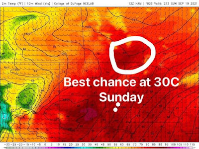
Good chance at seeing highs in the high 20’s and near or slightly above 30C on Sunday in the white circled area. There is a chance elsewhere but it’s less evident or probable as it’s only the RRV/SE on the NAM model I’m using. 

Saturday: Sunny skies are expected for Saturday, temperatures will rise into the mid to high 20’s (24-27C) the warmer temperatures will be in the parklands,with more moderate temperatures in the rest of the region. Saturday night:  there may be some more cloud on Saturday night as the warm front passes through. A few showers are possible in southern Manitoba overnight , a few rumbles of thunder are also possible but because of capping no organized storms are expected. Temperatures will drop into the mid to high teens, (14-17C) closer to our normal day time highs, oddly. 

Sunday: Will be one of the warmest days we will probably see this season, and probably not again until next year. A cold front will likely cross through the red river valley and the eastern half of Manitoba by afternoon, despite this we will still have calm weather conditions with a majority of the unstable weather occurring in NW Ontario. There is a solid chance at seeing our daytime high temperatures soar into the mid to high 20’s with some areas seeing 30C (25-31C). The best areas for seeing the 30C mark include the Red River valley, Winnipeg and eastern Manitoba. Winnipeg definitely has a chance at seeing 30C on Sunday. 

Sunday Night: An approaching trough of low pressure will sink south ahead of it it’ll allow for a batch of heavier cloud cover with showers and some rumbles of thunder to move into our area, mainly from North Dakota late overnight into the morning period. Temperatures will drop into the low to mid teens (12 to 15C). 

First half of the week: Showers and embedded thunderstorms will occur for the first half of the day and last into the early evening. Severe weather is not expected however. Much cooler weather is anticipated as a northwesterly flow takes over, temperatures will change and drop well into the low to mid teens for daytime highs (11 to 15C). The coldest air appears to sit in the western half of Manitoba where a northwesterly flow will be present. Milder weather is likely for Tuesday with calmer weather conditions expected thanks to a building area of high pressure, even warmer weather possible on Wednesday as the high pressure moves off into Ontario bringing a southerly flow back to our area. I’m seeing a chance at us seeing the 20-25C range again . 


Monday, September 13, 2021

Seasonal week ahead, increasing threat for storms midweek?!

 Much of our region has experienced seasonal to slightly above normal temperatures over the past few days, this trend looks to continue as a persistent zonal flow sits over the region. A trough will sit over our region which will inhibit our temperatures from rising into the 20’s. 


Monday Night: An area of showers and weak thunderstorms are expected to rumble through the southeastern half of Manitoba , with some spotty thunderstorms in the southwestern half of Manitoba by Melita east into the Killarney regions. The cold front looks to exit the province overnight, there is a chance of a stray shower or 2 before it leaves our region. Clearing skies are expected for the evening into the overnight period. Temperatures will drop well into the high single digits, (8 to 10C) in areas of southwestern Manitoba and low teens (11 to 14C) in the southeastern Manitoba region. Winnipeg: Partly cloudy 30% chance of showers early this evening. Then clearing. Low 10C. Brandon: Clearing, low 6C. Dauphin: Clear. Low 9C. 

Tuesday: Will end up being one of the nicest days to come this week, sunny skies thanks to high pressure in the northern plains will contribute to this. There’s a good chance at seeing the 20-25C mark for a large section of the south, the only exception is the interlakes north of Teulon where highs will be in the high teens (17-20C). Manitoba lakes might manage to reach the 20C mark or slightly warmer. Winnipeg: Sunny, high 23C. Brandon: Sunny, high 22C. Dauphin: Sunny, high 21C. 

Tuesday Night: Clear skies are likely as a high pressure system to our south keeps the weather stable, alongside with a southerly flow if we were in the middle of the summer we would be talking about lows in the teens or 20’s. However because we are approaching fall even with a southerly flow in place our temperatures will not sit in the teens overnight instead they’ll be much cooler than what we are used to. Lows into the mid to high single digits are likely (6 to 10C), with the exception of the Manitoba lakes and eastern Manitoba seeing lows a degree or 2 above 10C. Winnipeg: Clear, increasing clouds before morning. Low 9C. Brandon: Clear, increasing clouds before morning. Low 6C. Dauphin: Clear, increasing clouds by morning. Low 11C. 

Wednesday: A low pressure system will be coming into Manitoba with the warm front hovering over the red river valley area by late afternoon and this will be a difficult forecast, a lot of uncertainty with the timing and impact of precipitation expected. However, it appears possibly that cloudy skies with a chance for showers will come through in the morning. However the NAM appears to be the outlier on this, the RDPS and the GDPS show a chance for mostly cloudy skies to patches of sun in areas of the south. Regardless, there will be a chance for showers in the morning. Then partly cloudy to mostly cloudy skies in the afternoon, increasing amounts of instability will be present 1000J/Kg or Joules per kilogram (amount of energy per kilogram in the atmosphere) Moisture won’t be lacking either with the dewpoints, sitting at 13C increasing to 15-16C by early evening. Also there will be adequate shear, with around 40-50knots of bulk shear, enough to support storm Organization. Once the warm front and attendant cold front come through in the evening an increasing risk for thunderstorms may occur if enough daytime heating can occur. The risk for thunderstorms will be in the red river valley and eastern Manitoba during the late afternoon. We should know more about the severity of storms possible by Tuesday evening. My best weatherman’s guess is the risk for large hail, damaging wind gusts over 90km/h because of the shear present as well as torrential rainfall. There also is a chance the best dynamics could move into Ontario. We will keep you updated. Winnipeg: Mainly cloudy, with 30% chance of showers in the morning and near noon. Becoming partly cloudy in the afternoon. 60% chance of showers with the risk of thunderstorms late in the afternoon. High 25C. Brandon: Cloudy with 30% chance of showers in the morning, then partly cloudy. High 26C. Dauphin: Mainly cloudy, with 60% chance of showers in the morning. Becoming partly cloudy in the afternoon. High 26C. 

Wednesday Night: Showers and or thunderstorms will likely occur in the early evening in the red river valley into Ontario, will probably exit the province by evening. Forecast may change if the timing of the system changes. Temperatures will of course drop into the low teens (10 to 15C) for areas of southeastern Manitoba, the parklands and the Manitoba lakes. Areas in the red river valley, southwestern Manitoba, and the interlakes will once again drop into the mid to high single digits (6 to 10C). Winnipeg: 60% chance of showers in the evening with the risk of thunderstorms, some may be severe. Clearing in the evening. Low 10C. Brandon: Partly cloudy 30% chance of showers early in the evening with the risk of a thunderstorm. Clearing in the evening. Dauphin: Partly cloudy low 13C.

Second half of the week: Sunny skies are likely on Thursday and Friday , with increasing cloud possible on Friday night. I’m also seeing a large swath of precipitation develop on Friday night into Saturday on the GDPS, the NAM hasn’t caught on to it yet. There may be a possibility that we could see a batch of thunderstorms on Friday night ahead of a warm front. Other than that our day time highs will vary from sitting in the high teens and low 20’s, (16 to 22C) with our overnight lows in the high single digits and the low teens. 

Featured Post

Showers and Thunderstorms likely tonight

 Southern Manitoba will be likely getting severe weather this evening and overnight as another round of severe storms is possible, thanks to...