NEW INFO: The blogs from here on out will have shorter overnight forecasts unless there is significant weather expected.
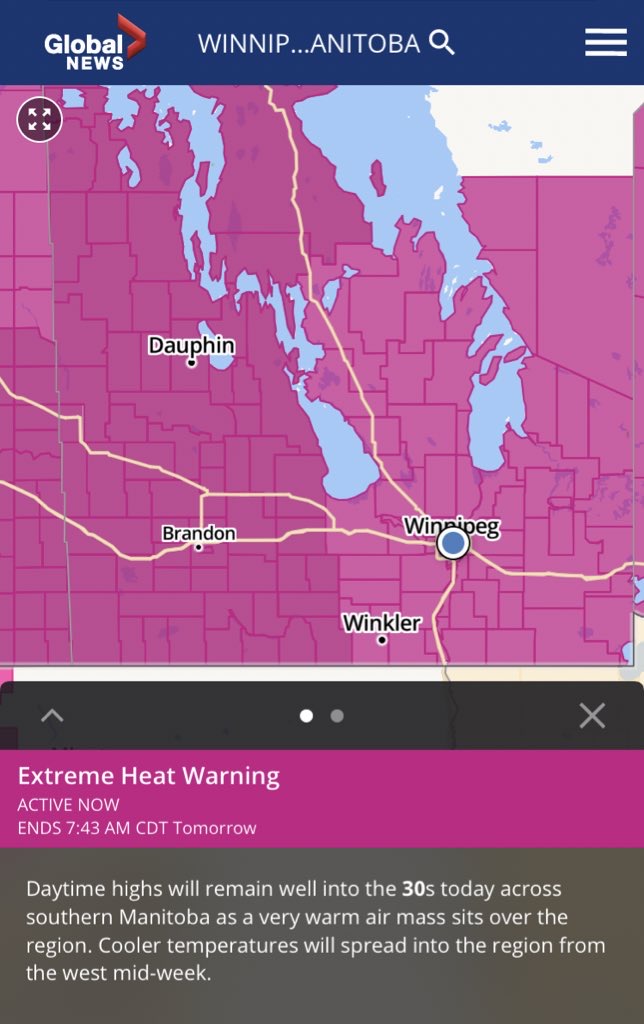
Much of southern Manitoba is in store for very hot conditions over the coming days, and it’s no surprise considering how our summer has been so far we have had already 5-10 heatwaves. A high pressure system off in the NE USA and Ontario is resulting in this persistent heat, with ridging over our area. This heat will likely come to an end over the coming days as a cold front pulls through. Find out when this heat will end and what we can expect for thunderstorms , below.
Monday Night: A cold front will be sitting over the region tonight into Tuesday, there will be a risk for thunderstorms in areas of the Red River Valley into eastern Manitoba. There is a possibility that some of them might end up being severe, however capping appears to be present so there will be a very low risk of anything developing. Overall hazy conditions are likely as smoke drifts in from the fires in British Columbia, which may result in smoke being brought down to ground level at times. Temperatures will drop into the high teens to low 20’s (17 to 23C) for a majority of the south with the warmest weather occurring in the southeastern half of Manitoba and the coolest occurring in the western half of Manitoba by Dauphin. Winnipeg: Risk of a thunderstorm this evening, clear low 21C. Brandon: Clear, local smoke and haze. Low 19C. Dauphin: Clear, local smoke and haze. Low 18C.
Tuesday: Will end up being hot again, sunny skies and local smoke will once again be in play. A cold front will be sitting by the American border during the afternoon It will also be one of Temperatures will soar into the high 20’s (25 to 30C) and low 30’s (30 to 35C)for much of southern Manitoba. The dividing line of temperatures from high 20’s and low 30’s will be through just south of Riding mountain national park , into the interlakes to just south of Bissett. Winnipeg: Mainly sunny, then 30% chance of showers in the late afternoon with risk of thunderstorms. High 32C. Humidex 38C. Brandon: Sunny, then partly cloudy with 30% chance of showers. Risk of thunderstorms in the late afternoon. Local smoke high 32C . Dauphin: Sunny , then partly cloudy with 30% chance of showers. Risk of thunderstorms late in the afternoon high 32C.

Tuesday Night: Indications are that there will be enough instability built up from in the afternoon to evening for thunderstorm development some severe by mid to late evening. (Photo above shows the amount of most unstable CAPE available for thunderstorms on Tuesday night if the cap breaks). However because of capping there will be a low risk for any thunderstorms to develop. There will be a risk for large hail, damaging winds, heavy rainfall and as stated by ECCC a risk for gusts of 90-100km/h (IF storms can break the xap and develop) The risk for thunderstorms and severe weather appears to be from Riding mountain national park south to the American border east towards Winnipeg and eastern Manitoba with CAPE in excess of 2,000J/Kg. Essentially all of southern Manitoba will be at risk for thunderstorms and some severe thunderstorms during the evening into the overnight. Temperatures will drop into the mid to high teens (15 to 20C) in the southwestern half of Manitoba while , low to mid 20’s (20 to 25C) are forecast in the southeastern half of Manitoba. Winnipeg: Clear, then partly cloudy with 30% chance of showers with risk of thunderstorms in the evening. Low 21C. Brandon: Partly cloudy with 60% chance of showers and risk of thunderstorms in the evening and after midnight. Low 15C. Dauphin: Partly cloudy, then 60% chance of showers with risk of thunderstorms. Low 15C.
Wednesday: Will be one of the less unstable days, a small band of showers and thunderstorms will move through central portions of Manitoba , and parts of the interlakes in the morning hours. Sunny skies are expected for the afternoon, capping will prevent thunderstorms from developing despite there being a low pressure system sitting over the area. Areas in all of southern Manitoba will have a chance at showers and thunderstorms during the day, lower risk further east. Whether they will be severe depends on the dynamics. We’ll look more on Wednesdays post. Temperatures will soar into the mid to high twenties to the low 30’s (25 to 35C). A few areas in extreme southern sections of Manitoba may have a chance at seeing high 30C temperatures. Winnipeg: Sunny. High 33C. Brandon: Sunny, then partly cloudy with 40% chance of showers and risk of thunderstorms. High 25C. Dauphin: Partly cloudy, then 60% chance of showers with risk of thunderstorms high 17C.
Wednesday Nigbt: Clear skies are expected for the night however areas through southwestern Manitoba into the parklands and interlakes regions have a chance at showers and thunderstorms during that period. If the front moves far enough south there is a chance the southern half could see showers and thunderstorms that chance is low though. There is a likelihood they could stay there for the overnight period in a line mainly through the parklands into east central Manitoba. Temperatures will drop into the mid to high teens (13 to 18C). Winnipeg: Clear, risk of thunderstorms in the evening. Low 20C. Brandon: Clear, then partly cloudy with risk of thunderstorms in the evening. Low 16C. Dauphin: Clear, risk of thunderstorms in the evening. Low 15C.
Second half of the week: The trough of low pressure that sat over our area during the first half of the week, will start advancing further east allowing for multiple low pressure systems to move through our area. There will be a much higher risk of seeing showers and or thunderstorms. The risk for severe weather may be there as well, it remains to be seen in the model data. Temperatures will vary from being in the mid to high twenties and low 30’s on Thursday to the high teens and low 20’s on Friday. Overnight lows even cooler sitting well into the mid to high teens for the second half of the week .


No comments:
Post a Comment
Thank's for commenting on the blog, I appreciate it...