Tuesday, June 28, 2022

Calm Seasonal Weather to turn Unsettled, Severe Weather Returning?

 Calm seasonal weather has been in place this past week since that bout of severe weather arrived last Friday, that is forecast to change as a low pressure system is forecast to move into southern Manitoba on the day Wednesday. Read on to Find out what that means for us and the second half of the week. 


Wednesday: A developing low pressure system will move into southern sections of Manitoba, during the morning a warm front will bring a batch of showers through the region with most of the unsettled weather clearing the area by late morning. The attention then comes towards the afternoon and evening hours when a warm and increasingly humid airmass will move into the area. Temperatures will rise into the mid to high 20’s with the warmest of the weather happening in the southern half of Manitoba, areas in the interlakes and the parklands will reach the low 20’s. The dew points will reach the mid to high teens possibly low 20’s. Also with the SBCAPE and MUCAPE expected to approach the 1,000 to 2,500 J/Kg mark. Shear values reaching the 100 to 500m2s2 will result in the risk for severe weather during the afternoon and evening. A cold front will slam into this unstable environment, unfortunately or fortunately wherever you go for storms there appears to be a cap in place which may inhibit thunderstorm development until the late afternoon and early evening when the cold front goes through with the risk persisting into shortly after midnight. What this means is that all modes of severe weather is possible with supercells being possible with damaging winds, large hail, and flooding rains. Tornadoes are also possible. The best risk areas as shown above from the Graphic from Environment Canada. Model land is still all over the place on where thunderstorms will impact the region, with most of the southern half of Manitoba at high risk of severe weather, the exception being the interlakes and the parklands where the risk is moderate. We at Manitoba weather centre will update you on the severe weather risk expected during the day if any alerts get issued. 

Wednesday evening: Showers and thunderstorms are likely during the evening hours and early overnight with the risk of severe weather  before a general clearing can be expected into the late evening hours or early overnight. If storms go through earlier in the evening clearing can be expected overnight. Temperatures on Wednesday night will drop into the low to mid teens. 

Thursday should be a much calmer day weather wise with sunny skies expected for the region except some cloud and possible showers in the morning. Temperatures on the day will rise into the high teens, possibly low 20’s. Thursday night should be much of the same with overnight lows dropping to the high single digits in the southwest to the low teens in the rest of southern Manitoba. 

Friday (Canada Day): Should end up being a fairly nice day, there may be a few showers or weak thunderstorms  possible as another cold front moves through. Nothing severe is expected though. Temperatures will rise into the high teens to low 20’s. Friday night: A clear and cool airmass will take over and it’ll end up being a bit colder than normal with overnight lows in the high single digits expected to low teens. 

The weekend: Quiet and sunny weather expected with a chance for showers and thunderstorms are possible on Saturday albeit low, temperatures will rise into the low 20’s to high 20’s on Saturday with overnight lows on Saturday dropping into the high single digits in the SW to the low teens in the southeast. Sunday much of the same expected with highs in the high teens and lows in the low teens to high single digits. 

Thursday, June 23, 2022

More heat and humidity to fuel Multi Day Severe Thunderstorm potential

 Southern Manitoba will experience a multi day thunderstorm threat today through into the first half of the weekend, increasing heat and humidity ahead of a few low pressure systems will increase the severe weather potential. Find out where the hottest of the weather means for us and where the severe weather will be located. 


Severe Weather threat expected on Thursday evening, risk area above, that moves south and east on Thursday night. 

Thursday: Much of the region will be basking under sunny skies today ahead of a low pressure system arriving from Saskatchewan. The low pressure system and will be the culprit of a severe weather threat arriving in the region late this afternoon and early evening. Temperatures today will soar into the low high 20’s and the low 30’s across the southern half of Manitoba with the highest temperatures along the American border. Most of the active weather isn’t expected to arrive until this evening, however there may be some scattered severe thunderstorms developing late this afternoon with some large hail possible with tornadoes a threat into the parklands. 


(Above: The HRRR is hinting at a squall line of some kind moving through Winnipeg overnight, latest model runs have it moving through between 10pm-2am.) This is just a possible outcome.

Thursday Night: The low pressure system I mentioned will enter the province this evening bringing with it a large area of instability and shear supportive of severe thunderstorm and supercell development which will likely occur in Saskatchewan. A general area of 1,000 to 3,000J/Kg of CAPE (Thunderstorm Energy) is forecast to move through the southwest parklands and western half of Manitoba this evening. This energy could extend far enough east and south into the south central part of Manitoba this evening to support thunderstorms in the region some of which may be severe. Severe Thunderstorms and Supercells could form in western and southwestern Manitoba and travel east southeast through the evening, it’s hard to tell where they will develop but when they do a risk for large hail. Some of the high resolution models have shown an area of thunderstorms moving through the southern half of Manitoba particularly the red River valley overnight as the supercells transition over to a squall line. There’s a risk with these thunderstorms for gusts over 80km/h, hail up to the size of loonies or golf ball size hail. Overall overnight low temperatures tonight will drop into the low 20’s in the southeast to the the mid teens in the western half of Manitoba and the interlakes where lows will drop into the low teens.


Friday below….


 (Forecast Severe Weather Map above for Friday, courtesy of ECCC Thunderstorm outlooks). 

Possible thunderstorms and severe weather for the day on Friday, this model from weatherlogics.com suggests a setup for a squall line moving through later in the day. Will monitor this for changes. As well the NAMNEST below is showing something similar but earlier in the day. 


Friday: This is where the forecast gets a little more complicated, model data is all over the place with regards to thunderstorm development and the system coming in tomorrow afternoon. Regardless another low pressure system will be coming into southwestern Manitoba gradually moving east through the day time. Temperatures in the south central and southeast will soar into the mid to high 20’s with some areas in the low 30’s, areas in the southwest will soar into the high teens low to mid 20’s. Dewpoints will also be in the mid to high teens and low 20’s , higher in the southeast.  Ahead of it a warm moist airmass will be in place, with moderate to high CAPE levels (Convective Available Potential Energy) if showers in the morning can clear soon enough and thunderstorms don’t develop stateside and push the energy south of the American border, There should be enough room for a squall line to form in the western part of the red River valley or pembina escarpment. Mainly between MacGregor and Elie south to the American border or the red River valley. Severe thunderstorm are possible with all modes of severe weather likely to develop tomorrow, for southwest Manitoba into the interlakes, red River valley and the southeast part of Manitoba. With a high risk area in the southwest to the red River valley into southeast Manitoba including the possibility of 90-110km/h wind gusts, 3-5cm hail, 50mm of rain or more and a tornado threat. A moderate risk area into the parklands and the interlakes and east central MB with 90km/h winds possible, 2cm hail and 30mm of rain or more. ***Note: Much of the severe weather should occur stateside if thunderstorms don’t form on our side of the border.**   


(Above): Forecast rainfall amounts for by Friday night: information and map from https://viewer.weatherlogics.com/models.html Significant rainfall likely in thunderstorms that develop on Friday and Friday evening.

Friday Night: Showers and Thunderstorms will likely persist in the southern half of Manitoba, the latest RAP model is showing a swath of showers and thunderstorms moving through the southeast in the early evening. Before a general clearing takes place in the evening hours. Temperatures on Friday night will drop into the low teens into the mid teens, with lows around the lakes dropping down to around 10C.

Saturday: A generally cooler day will be in store with high temperatures in the high teens to low 20’s. The warmer air appears to be in the southeast on Saturday. There may be a resurgence of showers and thunderstorms in the south in the afternoon but non severe thunderstorms are expected, if at all. 

Saturday night: Increasing cloud cover is expected with a likelihood of showers as a low pressure system builds southwards and we flip around to the backside of the low. There may be some rumbles of thunder. Temperatures will drop into the high single digits in rural areas, with a majority of the region seeing lows in the low teens. 

Sunday: Partly cloudy skies are likely on Sunday with a brisk northerly flow in place. Temperatures are likely to rise into the high teens into the low 20’s. Sunday Night: Clear conditions are likely overnight into Monday, with temperatures in the low teens.  

Monday, June 20, 2022

Heat and humidity give way to cooler and unsettled conditions, showers and thunderstorms possible.

 Much of southern sections of Manitoba have experienced a wild weekend full of heat and humidity, temperatures in Winnipeg soared to highs in the high 30’s yesterday with the humidity feeling more like the mid to high 40’s. 

This is the following information from Environment Canada on the heatwave from yesterday including records broken. Details here: https://weather.gc.ca/warnings/weathersummaries_e.html


Winnipeg Area 
New record of 37.0 
Old record of 33.3 set in 1888 
Records in this area have been kept since 1872 

Carberry Area 
New record of 35.7 
Old record of 33.5 set in 1995 
Records in this area have been kept since 1962 

Carman Area 
New record of 36.9 
Old record of 32.8 set in 1911 
Records in this area have been kept since 1895 

Deerwood Area 
New record of 36.5 
Old record of 32.5 set in 1995 
Records in this area have been kept since 1952 

Dominion City Area 
New record of 38.0 
Old record of 34.5 set in 1995 
Records in this area have been kept since 1942 

Emerson Area ( 
New record of 38.0 
Old record of 34.5 set in 1995 
Records in this area have been kept since 1893 

Fisher Branch Area 
New record of 33.8 
Old record of 32.5 set in 1995 
Records in this area have been kept since 1960 

Gimli Area 
New record of 33.6 
Old record of 31.0 set in 1995 
Records in this area have been kept since 1944 

Gretna Area 
New record of 36.9 
Old record of 34.5 set in 1988 
Records in this area have been kept since 1949 

Mccreary Area 
New record of 32.5 
Old record of 31.0 set in 1988 
Records in this area have been kept since 1968 

Melita Area 
New record of 34.8 
Old record of 31.7 set in 1938 
Records in this area have been kept since 1936 

Morden Area 
New record of 36.7 
Old record of 34.0 set in 1986 
Records in this area have been kept since 1895 

Oak Point Area 
New record of 33.8 
Old record of 32.0 set in 1986 
Records in this area have been kept since 1970 

Pilot Mound Area 
New record of 35.1 
Old record of 31.3 set in 1986 
Records in this area have been kept since 1938 

Pinawa Area 
New record of 35.3 
Old record of 33.3 set in 1995 
Records in this area have been kept since 1915 

Pine Falls Area 
New record of 33.5 
Old record of 32.5 set in 1995 
Records in this area have been kept since 1922 

Sprague Area 
New record of 34.8 
Old record of 34.4 set in 1933 
Records in this area have been kept since 1915 

Steinbach Area 
New record of 35.9 
Old record of 32.0 set in 1995 
Records in this area have been kept since 1956

Please note that this summary may contain preliminary or unofficial 
information and does not constitute a complete or final report.

End/PASPC


Some wild weather, came through the interlakes however it was further north than I had previously expected. Regardless a pattern change can be expected to some cooler and more unsettled weather conditions. Read on to find out what that means. 


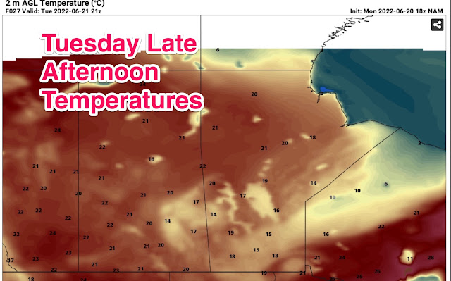
Above:) Forecast temperatures for the day on Tuesday. Much of southern Manitoba will be dealing with cooler weather on Tuesday thanks to a cold front moving through the region. This weather will be welcome after the heat we experienced. 


Tonight: An area of showers are currently moving through the red River valley and the southeast part of Manitoba, a cold front dragging southwards into the Dakotas with a warm front in Minnesota and NW Ontario will fuel a severe weather threat stateside. There’s a chance some of that activity could move northwards into southeastern Manitoba but that chance is low. Overnight tonight another low pressure system will swing into southwestern Manitoba, that will bring with it a batch of showers and embedded thunderstorms with it. There’s a chance they could stay strong as they move east into the red River valley where showers and a chance of thunderstorms are expected overnight into the morning. So mostly cloudy to partly cloudy skies are expected overnight before showers move in from the west. Temperatures tonight will drop into the high teens. 

Tuesday: Showers and thundershowers are still possible into the early afternoon heading from the southwest to the southeast. Mostly cloudy skies and scattered showers take place throughout the south, with clearing west to east by late afternoon and early evening. A cold front will move through in the early afternoon hours.Temperatures will be fairly warm in the southeast with highs reaching the low 20’s before they drop into the mid to high teens for a majority of the region. (15-19C).  

Tuesday Night: Showers should clear out by the evening with high pressure moving into the region, overnight lows will drop around 10C in the western half of Manitoba, with lows elsewhere between 11 and 16C. No sign of significant weather for the period is expected. 

Wednesday: A building ridge of high pressure will begin to fill into our region, temperatures will begin to rise again with a strong southerly flow. A trough of low pressure however is forecast to move into the western half of Manitoba sparking the potential for showers and thunderstorms to develop later on in the day. There’s a possibility some of them may become severe, whether or not it’ll turn out is still yet to be determined. This far out it’s hard to tell. Temperatures are expected to rise into the low to mid 20’s with the warmest of the air expected in the southwest part of Manitoba and the pembina and red River valley. 

Wednesday Night: Expect a possible chance of showers and thunderstorms to persist into the early evening hours,  before clearing conditions. If thunderstorms don’t happen expect calm and mild weather conditions. Temperatures overnight on Wednesday night will drop into the mid to high teens. 

Second half of the week: It looks like the heat might return with more unsettled weather conditions possible, again it’s dependant on how far north the heat dome moves up. Regardless expect normal to above normal temperatures to return for the second half of the week with chances of showers or thunderstorms. 


Friday, June 17, 2022

Heat and Humidity Return , severe weather as well??

 Southern Manitoba get ready for the heat and humidity through this weekend. It’s gonna be a hot and muggy one , it could also potentially be a very active weekend weather wise as a ridge builds over the province. Find out how hot it will get and where the severe weather potential is possible. It’s basically the reason there’s a special weather statement in place is the combined heat expected on Saturday and Sunday. 


(Above: Extreme heat and humidity will be in place on Sunday). Highs above 30C are possible with humidex values reaching the mid to high 40’s). 

Friday Night: The heat and humidity will begin to build tonight, a low pressure system in the western Canadian prairie provinces will begin to pump a hot and humid airmass into southern portions of Manitoba. Mostly clear conditions are likely overnight. Temperatures for a majority of the region tonight. Overnight lows tonight are forecast to drop into the mid to high teens with the humidity increasing it could even feel closer to the low 20’s overnight. 

Saturday: During the morning a front will go through ahead of the system expected for the weekend, a passing shower or non severe thunderstorm may go through. Nothing major is expected. Temperatures on Saturday will soar into the mid to high 20’s, humidex values will exceed the 30C mark in southwest parts of Manitoba, with a chance of that spreading eastwards depending on how high the dew point values will be further east.  

Saturday Night: Overnight an approaching low pressure system, will move into the dakotas ahead of it a very warm southerly flow will establish itself, dew points on Sunday night in the southwest will reach the high teens to low 20’s. 


Above: Graphics are showing intense heat and humidity with the projected humidex above , showing 40C or more on Sunday. 

 Sunday: Will be the hottest day of the week a low pressure system will move into the region on Sunday ahead of it a warm front will pass through bringing in a very hot and humid airmass into the region. Temperatures are also expected to soar into the low to mid 30’s, with some areas seeing values in in the high 30’s.  Dewpoints are expected to reach the high teens to low 20’s, with a chance of some locales seeing dewpoints in the mid 20’s even the high 20’s. This means the humidex values will likely exceed the 40C mark, with the average being between 41-46C. If conditions permit they could near 50C. 


Sunday Night (Above): The attention then turns to a passing low pressure system which will move through the southwest part of Manitoba during the early evening, and the rest of the evening across the south. *This will be a all or nothing event* There’s s chance the cap could hold and nothing forms, if the capping doesn’t hold then we could be dealing with explosive thunderstorm development* The details Scenario 1: High and extreme amounts of energy over the region, Thunderstorm Convective Available Potential Energy values of (3,000 to 6,000) in some cases 7,000J/Kg. With ample shear at upper and middle levels I cannot discount the risk of Tornadoes, with supercell thunderstorms  especially in the southwest part of Manitoba into the red River valley, before a damaging wind threat and severe hail with a line of thunderstorms. This could be one of those days and evenings to watch, for severe weather. Scenario 2: If nothing forms then we’ll be dealing with humid and hot conditions going into the night with clear skies.   

Temperatures on Sunday night will drop quite a bit if thunderstorms can form and go through that soupy environment, which would drop our overnight lows into the mid to high teens and low 20’s. Versus lows in the low to mid to high 20’s and humidex values in the low 30’s. Brutal. We’ll know more by Saturday evening about this outlook so I’ll have a detailed post for Sunday tomorrow evening . 

First half of the week: There’s still some uncertainty in the timing of the fronts but if it goes as predicted, there could be a potentially stormy day on Monday with a threat for severe weather again before cooler weather arrives for the second half of the first part of the work week. Temperatures on Monday will rise into the mid to high 20’s and low 30’s before a front goes through and cools off the temperatures  into the high teens to low 20’s. 


Monday, June 13, 2022

Unsettled Weather with Severe Weather Threat Possible for the week.

 Hope you all are doing well, summer severe weather season is on the way and it’s no surprise that another round of humid weather will possibly lead to another round of severe weather. You can thank this to a low pressure system moving into the western Canadian prairies which is bringing very heavy rainfall to provinces such as Alberta and Saskatchewan. For us there’s a good chance that low pressure system will affect us in some ways and it could be significant. Find out where and what areas are at risk in this blog. (I also have decided to simplify the information, so it should be a quicker read.)


Risk map tonight (Above: Severe Weather potential for southern Manitoba with severe thunderstorms a possibility in the overnight, I’m thinking that moderate risk area might expand more into Winnipeg and the red river valley areas as well as portions of eastern Manitoba.)

Tonight: A low pressure system will be sitting off to the west and the south which will be increasing the amounts of humidity from the southern states, dew point temperatures will sit in the mid to high teens which basically supplies a juicy airmass for thunderstorms to live on along with significant amounts of energy for thunderstorms to form, energy will be in the moderate to high range 2,000 to 3,000 Joules per kilogram. As that low reaches the international border and lifts north and east overnight more active weather looks likely. 

Details:

Round 1 Southwest and south central Manitoba including interlakes and Red River valley: A initial batch of thunderstorms could develop in southwestern and western Manitoba during the evening hours and early overnight which includes anywhere from Lake Manitoba west to Saskatchewan south to the American border, there’s a good chance that these will move from southwest to northeast with a chance they could enter the Red River valley into the overnight including areas from the American border north into the interlakes and including Winnipeg. If they move through they could bring large hail and heavy rainfall as well as strong winds. It’s hard to tell what will happen but if they do move through the second batch of storms may not be as severe. 

 Round 2 South central and southeastern Manitoba including the red river valley: This is when some concerns arise another batch of convection could move through the Dakota’s overnight and reach Manitoba by sunrise. The HRRR has been consistent at bringing them north through the red river valley and southeast Manitoba with weakening possible as it moves north, with the more severe parts moving through the southeast. Regardless if the MCS (Mesoscale convective system) can manage to sneak up into our area these thunderstorms could have bowing segments that would bring a possibility of wind gusts over 90km/h, with nickle size hail and larger as well as the threat of flash flooding. Tornadoes aren’t likely. 

In general a large swath of the southern half of Manitoba including the southwest , south central and southeast part of Manitoba has a risk of severe weather. Refer to the Instant Weather maps posted above, with environment Canadas map above as well. Temperatures tonight will sit around the mid to high teens with the humidity feeling more like the mid 20’s. 


Tuesday (Above: Severe Weather Threat in the morning). The initial batch of thunderstorms as mentioned will probably linger in the southeast part of Manitoba, with areas south and east of Winnipeg seeing a chance at severe weather in the morning and north and east of the city seeing a chance at thunderstorms. There could be a redevelopment of thunderstorms acrosss the south during the late morning and afternoon it’s difficult to say as there’s some disagreement on model data right now. There’s also a chance at a line of thunderstorms that could develop in southwestern Manitoba during the late morning hours into the early afternoon which may lift north and east. As for the rest of the province sunny to partly cloudy skies are likely during the afternoon. Temperatures on Tuesday will rise into the low to mid 20’s, with temperatures in the southwest dropping by the late afternoon into the mid teens. 

Tuesday Night: The low pressure system I mentioned earlier will move north into northern areas of Manitoba and will leave with it clearing skies and calmer conditions as we start switching over to more of a southwesterly flow. Temperatures for the period will be mild and slightly cooler with temperatures in the low teens and some areas in the high single digits. 

Wednesday: During Wednesday the low pressure system that I had mentioned will be moving into southwestern Manitoba and will move east throughout the day. Temperatures will rise into the low 20’s in the southeast part of Manitoba with temperatures in the southwest only reaching highs in the mid to high teens where cloudy skies are likely. Sunny skies are likely in the southeast. There’s a chance that during the day thunderstorms could form in the southeast part of Manitoba as the trough moves through with it, the threat for severe thunderstorms will be significantly lower than  tonight and on Tuesday but some marginal hail and heavy rainfall could be possible especially from late morning to early to late afternoon. 

Wednesday Night: Showers are likely with some periods of possibly heavier rainfall possible . Temperatures on Wednesday night should drop into the low teens with some area in the mid teens. A slight chance that some rural areas could see lows in the high single digits. 

Second half of the week: Temperatures will remain slightly below normal, as a cooler air mass sets in. Our daytime highs will feel more spring like with most places seeing temperatures in the mid to high teens on Thursday and on Friday we will see a return to the low 20’s with lows in the low teens on Thursday night and lows in the high teens on Friday Night. A sign of more significant heat and humidity looks to build in by the weekend but we’ll know more when we get closer to the second half of the week and the weekend. 

Saturday, June 11, 2022

Warm Weather leads to Thunderstorm potential. Severe weather possible.

 Hello everyone. I have finally gotten back to being online and I will be trying my best to cover the active weather over the next 24-72 hours and longer. I’ll be doing a brief but quick update on the weather for the this weekend. Here it goes… Much of Southern Manitoba will be in for some unsettled weather this weekend and the risk for severe weather will also increase along with the heat and humidity. Find out where and when the worst of the weather can be expected in this latest blog. 🙏🏻. 


Saturday: The day will start sunny, there will be a possibility of some cloud cover in the early morning hours throughout the afternoon with clearing gradually across from west to east as a low pressure system approaches. Capping fortunately will prevent storms from developing until later on. There will also be a risk for showers and pop up thunderstorms as the afternoon hours roll in with a slightly unstable airmass. Severe weather isn’t expected however the chance of some heavy downpours are possible. During the day temperatures will soar into the low 20’s to mid 20’s. 

Saturday Night: Overnight into Sunday an approaching low pressure system will drag in a occluded front which will be in the eastern part of Manitoba by morning. There’s a possibility overnight that there will be a swath of 1,000 CAPE (Storm Energy) that develops mainly in the Red River Valley and south of lake Manitoba to eastern Manitoba. As this front passes there will be a small chance of showers and thunderstorms that move through with Winnipeg and the red river valley at risk for thunderstorms. There will be a risk some of them could briefly become severe. I’m thinking the threat area will generally be from Carberry up to Gladstone down to the American border east to the Ontario border. Temperatures on Saturday night should drop into the low to mid teens with temperatures averaging our normal overnight lows. 

Sunday: This is when the forecast gets a little complicated and when I mean complicated it does get difficult. During the morning a possibility of showers and thunderstorms exist then partly cloudy to mostly cloudy skies are possible. Another low pressure system will move into our area bringing a threat for thunderstorms and ahead of it dewpoints will soar into the mid to high teens with temperatures in the high teens in the southeast to the low 20’s to mid 20’s in the red river valley to southwestern Manitoba. The threat for thunderstorms is conditional as cloud cover from morning showers and thunderstorms may inhibit daytime heating especially in the southeast. If any clearing takes place severe weather risk will increase substantially from what is expected, especially if temperatures rise into the mid 20’s. A general 1,000 to 2,000J/Kg of CAPE can be expected in the southwest to the red river valley, with lesser values of 700J/Kg to 900J/Kg in the southeast. 

Slight severe weather Risk area southwestern Manitoba, Red River Valley, Pembina Valley. Lower risk with general thunderstorms for the parklands and the interlakes regions.

Regardless I’m expecting thunderstorms tomorrow afternoon and early evening mainly scattered in nature and a slight risk for a severe weather threat to tomorrow with the risk of marginal to large hail, heavy rainfall and strong wind gusts, tornadoes are not likely as previously thought. The risk for severe weather will exist from southwestern Manitoba into the red river valley, with the highest chances along the Canadian border. There’s a chance that the severe weather could stay stateside. Again if it gets into the low 20’s instead of the high teens in the southeast part of Manitoba severe weather will exist there as well. I’m expecting any thunderstorms that develop to travel east with them dying out as the sun sets. Again temperatures in the high teens to low to mid twenties are possible. 

Sunday Night: There will be a chance for showers and thunderstorms during the evening before clearing skies takes over, with partly cloudy skies overnight. Temperatures will drop into the low to mid teens, with the chance some areas over lake Manitoba will drop to around 10C. 

Next week: Attention will turn to a developing low pressure system that could bring substantial amounts of rainfall as well as multiple rounds of thunderstorms. It’s too early to nail down the full details of this system, as model data is still yet to come in on this event. Temperatures however will soar into the mid to high 20’s during this period with overnight lows in the mid to high teens. With cooler weather possible on Tuesday with highs in the high teens and low 20’s. 

Tuesday, June 7, 2022

Warmth and Dry Weather Continues

Warm and sunny weather has finally set into southern Manitoba and it’s been consistent, something we haven’t seen in a long time. You can thank this warmer weather to an area of high pressure that has been sitting over our area for the last week, with a consistent trough of low pressure over the western part of Canada. Will this pattern break down ? How warm will it get ?? Read on to find out. 


Wednesday: Should end up being a beautiful day with sunny skies under the presence of high pressure. There may be a few pop up showers with day time heating especially southwest Manitoba where thunderstorms are possible between 12pm and 6pm. Temperatures during the day on Wednesday will warm up into the low to mid 20’s. With some areas in the southern red river valley seeing highs in the mid 20’s. Overnight partly cloudy skies are expected with some periods of cloudy skies in the southwest lows will drop into the low to mid teens with an area around Brandon dropping below 10C.  

Thursday: High pressure still in place for the area with calm weather continuing. Sunny skies and partly cloudy skies are possible in spotty sections in the region, temperatures are likely to sit in the low twenties with some regions in the southwest to the southern red river valley reaching the mid 20’s. Thursday Night: Clear skies are likely with some cloud cover in the south west part of Manitoba, temperatures in the low teens are likely overnight with areas around the lakes dropping down to around 10C. 

Friday: The morning will start out clear and sunny but by the early afternoon hours a band of showers will move in from Saskatchewan, there’s a chance that by late afternoon this could transition into showers with embedded thunderstorms mainly non severe. Amounts however  will only be in the 5-10mm range. Temperatures on Friday in the southwest will rise into the high teens to low to mid twenties with a possibility they could drop to the low twenties once the showers move in late afternoon. Temperatures on Friday elsewhere will rise into the mid to high twenties in the south central part of Manitoba with the same expected in the interlakes and the southeast. 

Friday Night: Most of the showers should clear out by the evening hours, weakening as they move into the red river valley. Thundershowers are possible still but nothing severe is at all possible. Temperatures on Friday night will drop into the mid to high teens.

The Weekend: Some unsettled weather will arrive for the weekend with an increasing chance for showers developing, temperatures will rise into the low to mid to high 20’s with a possibility of higher temperatures on Sunday. Overnight lows on Saturday night will likely drop to the mid teens to high teens and Sunday night lows might drop into the high teens to low 20’s. Thunderstorm and severe weather chances increase during the first half of the week next week as a trough sets up to our southwest. 

Featured Post

Happy New Year, Significant Winds Likely with Blizzard Conditions this weekend. Cooler weather arriving next week.

 Everyone welcome back to a new year in the weather scene hello everyone mike mcgregor here returning for the first post of 2025 and we'...