Friday, January 27, 2023

Extreme Cold Weather Arrives, Polar Vortex will likely influence our weather over the next few weeks.

 Hello Everyone Unfortunately, I have decided to take a hiatus on the blog (meaning weekly blog updates from now on) as not a lot of weather other than the extreme cold will be happening. Until the weather gets more active and if there is a change up in the pattern there probably won't be much in the way of weather updates. I'll still be sharing daily updates in the comments section, something that I havent done since 2014. 


Unfortunately it looks like a polar vortex will likely influence our weather over the next week heading into February. I'm seeing a very cold airmass sitting over much of the region. This same weather features sat over Russia and asia for the last few weeks. It doesn't look like any snowfall or significant weather will occur this weekend into next week. Temperatures will likely only sit in the low to mid minus 20's for day time high temperatures on Saturday this weekend with a likelihood of temperatures overnight into the low to mid minus 30's on the night Saturday. Theres a high chance that windchill values could drop even lower with a majority of the windchills this weekend. I'm seeing windchill values in the low to mid minus 30's during the day on Saturday and Saturday night likely even seeing the low's drop into the mid to high minus 30's. During Sunday similar values in the low -30's are expected.


There is a concern that the windchill values on Sunday night could exceed minus 40C and that will be a high risk for areas of southwestern Manitoba. (Above). 


That photo above is the polar vortex sitting right over southern Manitoba on Friday next week, that will likely end up being the coldest period of weather this year so far. Sunny skies and partly cloudy skies are likely during this period. Heading into the week and next week I see a concern for this cold persisting well into the end of the week. The only breif reprieve I see is during the day on Monday when a clipper will likely pass through the region, with our daytime high values rising into the high minus teens with windchill values in the low minus 30's. The cold weather returns next week with a vengeance, overall daytime high temperatures will fluctuate between the high minus 20's and high minus teens.


(Left): Overnight low's will likely persist in the low minus 30's to the high minus 30's with windchills at a risk of dropping well into the minus 40's. Wednesday looks like it will end up being the coldest period of weather during the morning where windchills could exceed minus 40C. 


(Above): There is a glimmer of hope however, a break in this cold weather is possible by next weekend. I see temperatures returning to the high minus teens, you can thank the return of some low pressure systems drawing in some warmer pacific air. How long this pattern will last is uncertain. In the mean time stay warm, maybe even sip on some hot chocolate. 

Wednesday, January 18, 2023

Mild Weather Continues for the foreseeable future.

 Much of our region has experienced a very warm January so far with periods of thick fog patches,  freezing rain, freezing drizzle and cloudy skies. A few weeks ago I even noticed it was misty outside. That is something you don’t see in January. Regardless you can thank this to the colder than average weather with the polar vortex impacting Russia and Siberia. Read onto find out when this pattern could change below…. 

Manitoba and Canada with the warmth across the North American Continent….


Below a photo of the polar vortex enveloping Russia and Siberia currently showing temperatures in the -40 to -50C range… That is cold!!! 


We won’t be seeing this polar vortex move locations for a period of time, thankfully. 

As for our weather this trend of warmer weather looks to continue thanks to the presence of a westerly to southerly flow aloft as high pressure sits to the north of us keeps us in a mild flow. Let’s have a look at the details… 

Rest of today: Temperatures over the next 12 hours will be mild, there will be a chance for freezing drizzle or light flurries this early evening moving up the red river valley into the inter lake regions. Cloudy skies will persist.  By this evening temperatures will range from the high minus single digits in the southeast to the low minus teens in the southwest hovering around the -8 to -12C mark. 

Tonight: Flurries and or freezing drizzle will persist in the overnight period into the morning hours mostly in the south central and southeast regions spreading all across the south by the overnight period . Temperatures will drop into the mid to high minus teens overnight . 

Thursday: Daytime high temperatures will rise into the low to mid minus single digits. Mostly cloudy skies are expected with the chance of fog patches developing later in the day. Still a continued chance at flurries and or freezing drizzle across the region. 

Thursday Night: Overnight low temperatures will drop into the low minus teens and high minus single digits. Cloudy skies will persist for those in the southeast; however clearer skies are likely in the southwest. 

Friday: Temperatures will rise into the low to mid minus single digits with areas still seeing unseasonably warm air some areas may be close to the freezing mark!! Break out your shorts . The cloudy skies will likely persist until the afternoon hours with a chance at clearing skies by the mid to late afternoon hours from west to east.  

Friday Night: Some of the mildest air will stick around with lows only sitting in the mid to high minus single digits a chance at colder values however are possible. A batch of snow showers are likely to move into the western portions of Manitoba overnight into Saturday morning. 

The Weekend: Saturday looks mild with daytime high temperatures remaining in the low to high minus single digits, snow showers are possible on Saturday before clearing on Sunday early morning. The cold weather arrives again on Saturday night as a trough moves through. Overnight lows on Saturday night could approach -20C but will sit in the mid to high minus teens windchills will likely be colder in the minus 20C to -25C range. Sunday the mild weather returns with slightly colder values in the high minus single digits and low minus teens. The same values expected to drop into the low to mid minus teens. 

Friday, January 6, 2023

Mild weather to Start 2023, Where did winter go ???

Hello and Happy New Year Everyone!!! 2023 is likely going to be an interesting year ahead weatherwise, with Manitoba you never know what your going to expect. As we look at the weather this weekend I’ll make this post short and sweet. 


Temperatures above for the day on Sunday. Warm and mild. I like it . 😯😊

Saturday: A warm front will be moving into southern sections of Manitoba and across the region from the start to the latter half of the day. Temperatures will be given a boost, with our values from the mid to high minus teens in the morning warming well into the high to mid minus single digits by the afternoon hours. 

Saturday Night: This warm and mild trend looks like it will continue into the overnight on the night Saturday into Sunday. Temperatures will drop only a few degrees below -10C, with a lot of the warm air centred from the northern parklands, inter lakes and nopiming park eastern regions.  I don’t see any signs of precipitation falling until at least mid week. However increasing clouds then cloudy skies will be in place likely over the area Saturday evening persisting well into the weekend  which will help us remain mild. 

Sunday: Temperatures on the day Sunday will likely rise into the mid to high minus single digits so the -4C to -9C range. Sunday night will feature cloudy skies and fog patches are also possible. 

Sunday Night: Temperatures on the night Sunday into Monday will continue basically just sitting in the values they were in all weekend. I’m only seeing the colder values in the central parts of Manitoba with lows there from -10 to -12C. 

The Week Ahead: Southern sections of Manitoba will continue to experience warm weather for the week, with highs in the low to mid to high minus single digits. However warm weather may end during the second half of the week during the overnight periods with lows reaching the low to mid minus teens. We will watch for any changes to this pattern . In the long range. 

The warming trend will likely stick around for next week this is all thanks to what we call ridging, and this is very unusual in the winter season during a La Niña pattern. 

Wednesday, December 28, 2022

Merry Belated Christmas and Happy Early New Year!

Merry Belated Christmas Everyone and I hope you had an amazing Christmas, I am hoping you all have a joyous holiday season. I am taking a break from blogging for a week or 2. I know that theres some significant freezing rain happening today across southern Manitoba. However I won't be covering this as I am taking some holidays. Justin Oretel on Manitoba Weather Centre is keeping up with it. I wish you all the best in this holiday season. As well I hope your new years 2023 will be blessed and amazing!!! Ill have a 2022 Year in Review sometime in the new year. Remember that the reason for the holidays, is Jesus being born to be the saviour of the world more than 2,000 years ago. The Gospel is 1 Corinthians 15:1-4  God Bless. 

1 Corinthians 

15 Moreover, brethren, I declare unto you the gospel which I preached unto you, which also ye have received, and wherein ye stand;

By which also ye are saved, if ye keep in memory what I preached unto you, unless ye have believed in vain.

For I delivered unto you first of all that which I also received, how that Christ died for our sins according to the scriptures;

And that he was buried, and that he rose again the third day according to the scriptures:


Tuesday, December 13, 2022

Significant Colorado Low Set to Slam Southern Manitoba

 Southern Manitoba will likely get impacted by a significant Colorado Low Pressure system over the next 24-48 hours. Unfortunately it looks like this system might stick around until at least Thursday. This system will have significant impacts, a batch of freezing rain ahead of the system went through southern sections of Manitoba during the overnight period into the morning today, and it’s beginning it’s impacts on southern Manitoba. This may end up being the first significant storm of the 2022-2023 winter season. Read on to find out more. 


Tuesday: Much of the day will remain cloudy and mild as we sit in the warm sector of the low pressure system, for those who sit around today wondering where all the snow is. It’s on the way. Today will be the calm before the storm, much of the snow at the moment is spiraling over northern North Dakota with snow lightly falling in western Manitoba. Winds will be light out of the south today with temperatures soaring into the high minus single digits, areas in western sections of Manitoba may see highs in the mid minus single digits. 


Tuesday Night (See above for reference): Heavy Snowfall will begin to develop over southern sections of Manitoba tonight, most of that will likely start by at least 9pm to midnight. Conditions will begin to deteriorate rapidly, snow and blowing snow will start mainly along and north of the international border. It’s hard to tell where the heaviest snowfall will occur, there’s a chance it stay’s stateside or lifts north of the border slightly. By morning it will finally reach the northern red river valley and the interlakes. This will be a multi day event so I will post snowfall totals expected at the end of this summary for the storm. Temperatures will drop into the low minus single digits.  So not a lot of cold weather expected. 


Wednesday: Snowfall will continue across much of southern sections of Manitoba this will likely move into the interlakes, parklands and much of northern Manitoba by the afternoon. Travel isn’t advised during the day on Wednesday. (See Photo for snowfall imagery above). Mild temperatures will continue for us, and bizzare enough that they will rise above zero for extreme southern parts of Manitoba near Winkler. 


Snowfall Totals: Southern sections of Manitoba especially along the American border may see as much as 20 to 30cm of snow including western portions of Manitoba. Areas along and north of highway 1 will see upwards of 10 to 20cm especially in areas of western Manitoba. Amounts will vary and if the snowfall area shifts the heavy amounts could very will shift . 

By the end of the Storm, including additional snow that falls on Wednesday night and Thursday a total of 10 to 15cm can be expected along and north of the Trans Canada Highway. 

Wednesday Night: Much of the southern sections of Manitoba will likely experience blowing snow continued with the low sitting over southern Minnesota. A brief reprieve from snow will happen heading into the overnight period before another batch of snow moves in from northwestern Ontario by morning. Temperatures will remain on the mild side as most areas only see lows in the low to mid minus single digits (-2 to -5C). 

The second Half of The week: Remnants of the low pressure system will begin to move east, and more snow and light snow will impact southern sections of Manitoba with another 2-5cm of snow likely into Friday. Temperatures will begin to drop on Thursday with highs in the upper minus single digits with the same on Thursday night. Friday and Friday night lows will drop into the high minus single digits and low minus teens right behind the low. 

Thursday, December 8, 2022

Colder Weather Ending, Warmer Weather arriving. ❤️❤️

 I know how all of you are thinking; this week and past several days has been a cold one. It is no surprise as much of our region has been locked in a cold airmass, as part of the polar vortex broke off and plunged into much of central and northern Canada. Can you brave one more day of cold weather?? Southern sections of Manitoba will likely experience one more day of cold temperatures before we finally reach some mild December temperatures, how will this happen, how warm will we get, how long will this last for??  Read on to find out more in the latest blog. 


Thursday: The warmth will be likely to take some time to move into southern Manitoba, Thursday will be one of the last coldest days of the week we will still be under the influence of arctic high pressure which will cause our daytime high temperatures to still sit below normal. It’s not until Friday that high pressure system moves east and will establish a southerly flow over our region. Sunny skies are likely during the day today with high temperatures rising into the low minus teens along and south of the trans Canada highway all the way to the American border from Sask border to the Ontario border. Mainly in extreme far southwest regions will be near -10C. Areas further north in the parklands and in the interlakes and Manitoba Lakes will see values in the low to mid minus teens windchills closer to the -25C mark. 

Thursday Night: The coldest weather will likely hit us tonight before a reprieve on Friday, much of southern sections of Manitoba tonight will likely see low temperatures in the mid to high minus teens and low minus twenties especially in western sections of Manitoba along the escarpment. Partly cloudy skies are likely with much of the region seeing some periods of heavier cloud. 

Friday: Much of that warmth I promised you will finally be moving into our area, thanks to a southerly flow on the east side of high pressure. A warm front will also be advancing north ahead of low pressure. High temperatures will likely rise into the low to mid minus single digits for most. The only exception will be areas over the Manitoba lakes where values will sit in the low to mid minus teens. Windchills will be in the low to mid minus teens for most, the only areas with colder windchills will be the Manitoba lakes where that will likely be in the high minus teens. 


Friday Night: Much of southern sections of Manitoba won’t cool down much on Friday night as we sit on the western side of a high pressure system. A batch of cloud should work its way west to east during the evening with clearing in the southwest but remaining cloudy in the southeast. Also a trough will move through on Friday night. Another round of snowfall is likely with varying intensity and snowfall rates, however only 2-5cm is likely and mainly areas from Portage La Prairie, Winnipeg, east to the Ontario border up into the Gimli and Ashern areas can expect to see snowfall. Blowing snow may be an issue as well because this system will be bringing gusts up to 10-30knots which is 30-50km/h. See photo above, for reference. Temperatures will rise into the low to mid minus single digits on Friday night. Barely any windchill. 

Saturday: During the day Saturday, for those in the eastern sections snow will continue with blowing snow and travel difficult in the extreme southeast part of Manitoba. Flurries are likely for a good part of south central Manitoba and interlakes on Saturday. Temperatures will rise into the high minus single digits close to 0C in the south central and southeast part of Manitoba, areas in the southwest and west will drop into the high minus single digits. Saturday night snow will taper off leading to partly cloudy skies overnight . Overnight lows will sit in the mid to high minus single digits. Lakes may be a bit colder than that. 

Sunday: Mostly cloudy skies are expected during Sunday, there will be flurries developing later in the day with a southerly flow in place. So high temperatures will rise, well into the low to mid minus single digits. Sunday night will also be very mild with high temperatures sitting pretty much where they were during the day, only some areas may drop a degree or 2 past -5C to -6C. Windchill will not be as bad either with values closer to -10 to -16C.  

The Week Details Coming in a Seperate Blog. Snowstorm is possible coming next week on the 14th, so I will have more details soon, as the day gets closer. That will be shared in a special blog on Sunday . So far though it looks like this warmer weather pattern continues into next week. 

Wednesday, November 30, 2022

Cold Weather arriving. Polar vortex on the way

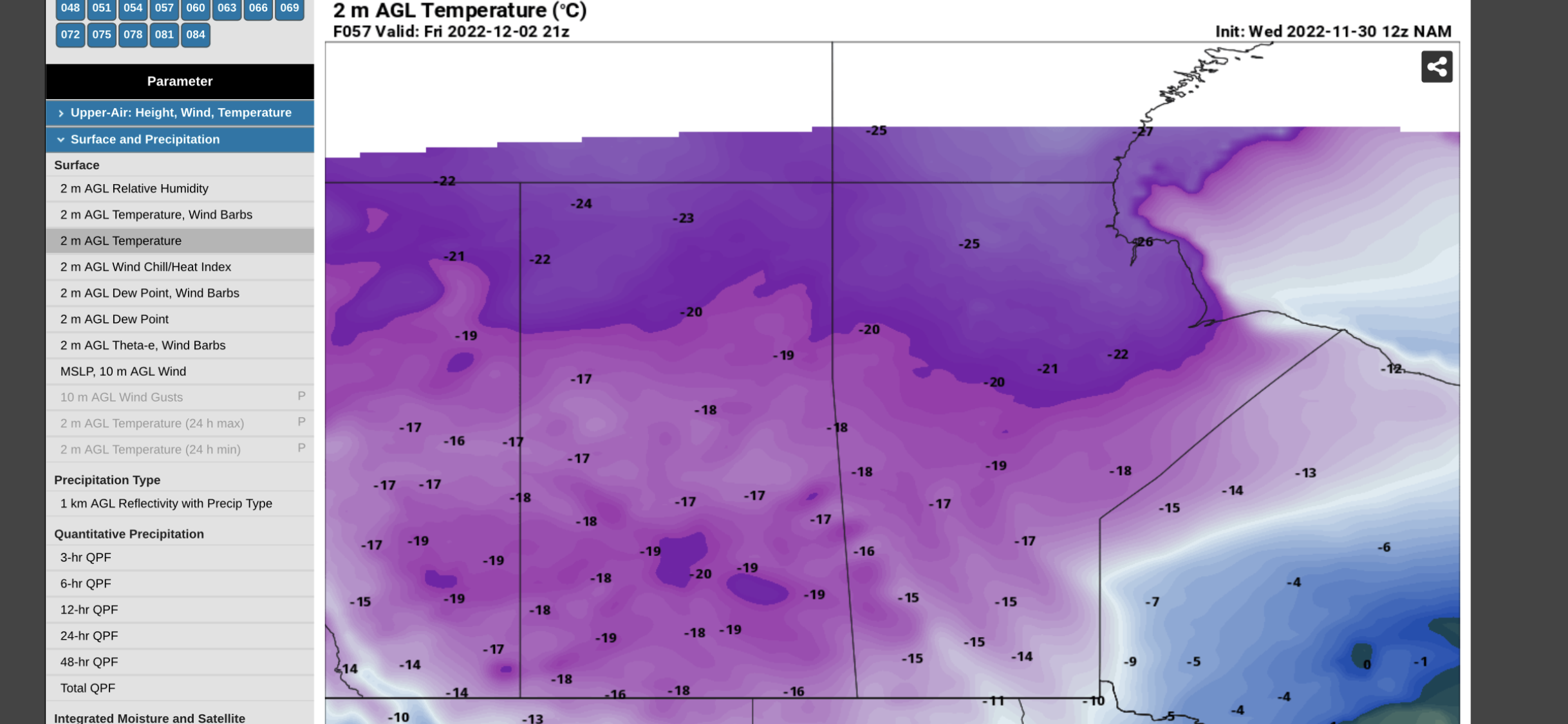
 Welcome back to Winter Wonderland in southern Manitoba, the snow is on the ground, the windchill is high and the roads are icy. For those thinking that summer would stay, unfortunately as the tilting of the sun and rotation of the earth winter has to come. Well the reality of it is you can thank this cold weather due to a polar vortex that is beginning to sink south over the Canadian prairies. That is detailed below in probably one of the coldest temperature values I have seen in a very long time, that below is on Friday afternoon 🥶🥶🥶. Find out how cold it will get and what we can expect weather wise, in southern sections of Manitoba. 


Tonight: We will be sitting on the edge of an arctic high pressure system as we experience a northwesterly flow aloft our temperatures tonight will be cold, crisp and arctic like. A good majority of our region will see overnight lows in the mid to high minus teens, with windchill values in the mid to high minus 20’s if you are in the Swan River and Assessippi Provincial park regions chances are windchills could be approaching minus 30C. Very little in the way of cloud is expected over all regions tonight. 


Extra Feature: 

This is one of those well known facts that the polar vortex becomes a yearly occurrence, the above image is a model run image of the polar vortex that is expected to impact a large portion of Canada next Tuesday. The arctic and the northern part of the United States. It will likely have impacts on our weather pattern over the next couple of weeks. Don’t worry; the polar vortex has been around for centuries but only has been brought into the mainstream recently thanks to the media bringing attention to it a few years ago. It is usually mainly over the arctic but it recent years it’s been displaced by warming in the stratosphere. Read more on the polar vortex here: https://www.weather.gov/safety/cold-polar-vortex I am seeing signs of a pacific push of air over western Canada come mid to late December, we’ll see if this verifies. 

Thursday: For those wondering about some milder temperatures, Thursday is pulling I guess a winter prank. A low pressure system will be skirting the USA border and with that it will bring in a batch of cloudcover, there will be some periods of sun mixed in. So sun and cloud likely on the day. Temperatures will warm up and they will turn out milder than all of this past week, high values will rise into the mid to high minus single digits. Windchills may feel slightly colder than that. In the evening hours a batch of snow and light snow will likely develop in southwest Manitoba. 

Thursday night: A low pressure system off to the south of us will pull in a cold arctic airmass as we sit on the north side of the low, a good chance of snow on the backside will likely bring 3-5cm. Depending on the intensity there will likely be some heavier bands but brief. Temperatures on Thursday night will stay mild in the southeast with temperatures in the high minus single digits, and areas just west of Elie seeing values in the low minus teens. Windchills will only be in the low minus teens in the southeast further west with values in the mid to high minus teens. Further north in the parklands a higher chance of values in the low minus 20’s. A large area expected to see snowfall, regardless of temperatures. 

Friday: Remnants of the low pressure system will move over southern Manitoba before going into Ontario in the later half of the day . Temperatures will only get colder behind an arctic cold front that will be sitting over the Canadian prairie provinces snow will begin to taper off towards the late morning hours to early afternoon. High temperatures will only be reached in the late morning to early afternoon hours in the low to teens for most. However most of the temperatures will drop by the late afternoon well into the mid to high minus teens by evening most of our area will be seeing wind chill values well into the mid to high minus 20’s, before dropping close to -30C (I mean -26 to -29C ) for a large majority of the south. Frostbite will be possible in minutes. 

Friday Night: Clearing will be likely with a majority of temperatures dropping well into the high minus teens to low minus 20’s. Windchills will likely sit well into the high minus 20’s and low minus 30’s. This is the kind of cold that can cause frostbite and becomes dangerous if skin is left exposed. Please dress warmly and stay indoors if you can. 

The Weekend: Another day of sunny skies is likely on Saturday. As well another batch of snow is likely on Sunday with about 1-3cm likely. Temperatures will warm into the high minus single digits closer to -10C on Saturday. Saturday highs should be stable and sit in the mid to high minus teens, Saturday night lows will rise into the low to mid minus teens, as snow builds in. Sunday will see similar temperatures with most areas seeing highs in the low to mid minus single digits. Warmer than earlier in the week. That cold builds right back in overnight well into the mid to high minus teens, areas in the inter lakes and parklands will see values well into the high minus teens with windchills in the minus 20’s. 

Enjoy the rest of the week and the weekend. -Mike 


Featured Post

Active weekend on the way to Manitoba

Well another weekend of active weather is set to impact southern Manitoba this weekend, thanks to a large trough setting up over western Can...