Monday, June 19, 2023

Heat, humidity, and thunderstorm chances return. Severe weather also makes a return.

 Southern Manitoba, will experience a very hot and humid airmass over the next few days we will be sitting over a very strong southwest flow as a ridge of high pressure sits off to the east in Ontario. Given the favourable upper pattern much of the region here will see a threat for severe thunderstorms as an amplified trough sits on the west coast and low pressure systems sit over our area. There will be concerns as this pattern develops, there is the potential for heat and humidity with severe weather and tornado threats. 


Monday early evening (Above): Today: mA complex weather situation will be working out today, a low pressure system sitting over southwestern Manitoba will increase the risk for severe weather as a cold front sits over the western half of Manitoba. Temperatures will rise into the high 20's and low 30's, dewpoint temperatures will also be a lot higher than the average lately with high values reaching the high teens and low 20's. There is a concern that because shear will be in the 50-60knots range that a tornado or 2 could happen. Instability will also be in the 1,000 to 2,000J/Kg CAPE range which increases the prospects that thunderstorms will develop. Overall there is a risk later in the to mid evening today for isolated to scattered supercell thunderstorms to develop with the risk for winds over 100km/h, golf ball to soft ball size hail, and heavy rain over 50mm likely. The best threat areas right now appear to be from the Saskatchewan Border east to Shilo or just west of MacGregor along a north south line from the North Dakota border to the northern parklands by Winnipegosis. After storms form there will be upscale growth into clusters or a MCS which will move north and may provide a risk for tornadoes after sunset into the early overnight hours. 


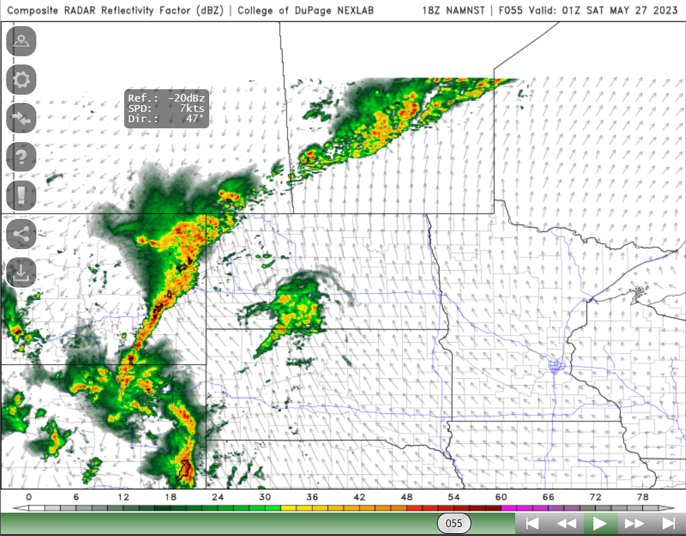
Monday Night (Above simulated radar images): Storms are once again forecast for the overnight period as another upper wave moves in from North Dakota, which will allow a mesoscale convective system to develop in western North Dakota. This same complex will move through southern Manitoba and it has an opportunity of bringing heavy rainfall in excess of 50-75mm, hail up to golf ball size wind gusts over 100km/h max could be as high as 120km/h this would be a result of bowing segments along the main line. There would also be a risk for a tornado or 2 especially earlier in the night in southwestern Manitoba. Main points are that this system will move from the southwest to northeast and move from the corner of the Melita and Coulter areas northeast into lake Manitoba and portage La prairie areas into the inter lakes and the red River valley. I have seen a few model runs bring it through the red River valley as far south as Morris. If it doesn’t hit the red River valley it has a higher chance of moving into the interlakes as it follows the LLJ or low level jet. Temperatures tonight will drop into the high teens and in the southeast ahead of the front most likely low 20’s are a strong possibility. 

Tuesday (Above): Is going to be one of those days you will definitely have to watch for; for severe weather (Threat map from EC above). This threat is going to be considered conditional as it’s all dependent on the convection from last night. If convection can clear in time and allow for sufficient heating then storms will also be a higher probability of being significant, also there could be outflow boundaries leftover from the storms during the night on Monday night and instability may be lower than expected. Regardless if these factors don’t play in then we can expect things to get wild tomorrow afternoon. I’m looking over model data for this event and dew point temperatures will more than likely rise into the low 20’s, and high teens across the south part of Manitoba. I am seeing temperatures rise into the high twenties and low to mid 30’s hotter in the southeast ahead of the front. Of concern will be a cold front sitting over the southern part of Manitoba which will provide a focus area for severe thunderstorm development. Based on what I’m seeing CAPE values will be over 3,000J/Kg and the EHI values are well within an area I would have concerns for supercell and tornado development. Overall during the latter half of the day there will be thunderstorms developing along a line from Pilot Mound to the Winnipeg region, moving into the interlakes and down into central North Dakota. These storms will move east southeast with initial threats of tornadoes, large hail up to Golf ball or larger  , damaging winds in excess of 100km/h. These storms will move into the southeast part of Manitoba during the evening hours.  We will know more as new model data comes in. Regardless rain and severe thunderstorms remain possible tomorrow. You can read up about the threat areas, from EC right here: https://umanitoba.ca/environment/envirogeog/weather/conv_otlk/ 

You can learn more about the convection values I used here: https://www.theweatherprediction.com/severe/indices/

Tuesday Night: Remaining convection from the storms earlier remain possible, and they will leave the province or weaken by 10pm-12am. Overnight low temperatures are likely to drop once again into the low 20’s in southeast Manitoba as far east as Portage La Prairie with lows westwards in the high teens. 

Wednesday: Another unsettled day is in store across southern Manitoba this time for south central and southeast Manitoba, a chance for early afternoon showers and thunderstorms are possible with a threat for some of them to become severe. The threat will then shift into eastern Manitoba into the afternoon as the front cuts through however this front again remains stationary so the threat for thunderstorms may continue in the red River valley towards the evening hours. Scattered thunderstorms are more than likely than organized severe weather. Temperatures on the day Wednesday will rise into the high 20’s in the south central and south east before dropping into the mid 20’s during the day. 

Wednesday Night: Another chance at convection moving into the red River valley and southeast part of Manitoba remains likely, possibly in the form of a MCS or thunderstorm complex which would bring a risk for damaging winds, hail and flooding rains. Details on this are still being worked out but we will know more as the data comes in through the next 12-24 hour period. Temperatures on Wednesday night will drop into the mid to high teens. 

Second half of the week: Calmer weather is in store as high pressure moves in which allows a stable airmass to return. Temperatures for the period will more than likely return to more normal values giving us a break from the heat with temperatures in the mid to high 20's and low to mid teens for overnight lows. 

Thursday, June 15, 2023

Warmer Temperatures and some Humidity Return for weekend, chances for showers. Hotter weather, soon?

 Hello again and welcome to southern Manitoba's weather update for the weekend, calm weather will be likely over the coming days as we end up on the eastern side of high pressure. This pattern will slightly change as we start our weekend, as the ridge moves east systems will begin to move eastwards over the canadian prairies along a branch of the pacific jetstream but will however weaken as they dump a lot of rain on alberta as they move east. Find out how this will impact our temperature pattern over the coming days and what we can expect for the coming weekend ahead. 

(Above: Temperatures forecast for the day on Sunday, highs are likely to reach the upper 20's and low 30's. Very Little in the way of humidity is likely as most of it sits off to the east). 

Thursday: A sunny and warm day can be expected as we start seeing a southerly flow over southern sections of Manitoba. There will be a chance for showers in the southwest during the afternoon, however that chance at the moment is less than 30%. There will be hazy skies due to smoke sitting over our area, and this is expected to persist through the evening, with some clearing in the west towards the latter half of the day. Temperatures will likely rise into the low to mid 20's, as a bit of cloudcover sits over the western half of Manitoba low 20's are likely. Thursday Night: A frontal system will likely develop and move through the southwest and southcentral part of Manitoba, there will be increasing cloudcover through the overnight. Temperatures during the overnight will likely drop into the low to mid teens for most.

Friday: During the early part of the day, there will be a chance for showers and weak thunderstorms over a portion of southern Manitoba, especially the southcentral and southeast parts from just south of lake Manitoba into the whiteshell. According to the models I have looked at there will not be much in the way of accumulations with only 2-4mm or 5mm at most. Moisture flow into this system is lacking significantly. Temperatures will more than likely rise into the low 20's and mid 20's. Friday Night: Clearing is likely as the frontal system moves out of our region, some residual cloudcover is likely over extreme southern Manitoba, this should help keep our temperatures quite mild overnight that is more typical of June with lows in the mid to high teens a very distinct possibility.  

Saturday: Some beautiful weather is likely for the weekend, the day on Saturday will be marked by warm temperatures, and increasing amounts of humidity which I see a possibility as Friday wasnt as  humid Saturday will be. There will be a risk for thunderstorms in areas of southeastern Manitoba on the west side of a trough of low pressure, mostly non severe thunderstorms are a possibility. Temperatures will rise into the low 20's to mid 20's, cooler in the southeast part of Manitoba. Saturday Night: Overnight clear skies are likely as the system moves off into Northern Ontario, this same setup will allow temperatures to drop again into the low to mid teens, with the warmest areas in the parklands by Dauphin.

Sunday: Calm weather is again likely, however we will be south of a area of low pressure centered over Northern Manitoba. Temperatures will likely rise into the mid to high 20's or low 30's, with sunny skies likely during the afternoon. Low pressure will sit off to the west of us, which means a nice westerly flow will be present. Sunday Night: Much of the region will see clear skies again, there will be some smoky or hazy skies, overnight lows will likely remain very mild on Sunday night with areas seeing values in the mid to high teens. A few areas may see lows hanging around 20C in urban areas, especially in cities, towns in the Red River Valley. 

The Week Ahead: Yes Hotter and more humid conditions will return! Some chances for storms returning during the week, a ridge will sit off to the east of us with a southwesterly flow present over Saskatchewan and SW Manitoba bringing a more southerly flow to our area. Temperatures will likely return into the low 30's to start the week, with a few systems of low pressure to watch for thunderstorms I'll know more by Sunday/Monday. Chances for sun and heat will continue. No Wonder the Ex is in town. 


Have a good weekend. -Mike.


Friday, June 9, 2023

Seasonal temperatures, calmer and stable weather arriving. Hints at the long range.

 Much of southern Manitoba is expecting a shift over from very unsettled weather conditions and a streak of multiple days of severe weather. That pattern looks to finally end by this weekend, cooler more seasonal temperatures are likely. Let’s find out what is happening with the pattern and how long this might last for. As we get into the next few days, a welcome reprieve from stormy weather is likely.There will be a risk for haze and smoke to filter in as wildfire smoke moves along with the jetstream that will move over us, through the weekend. 


Friday Night: Clear skies are likely across southern Manitoba on Friday night overnight low temperatures will likely drop into the mid teens in the southeast, low teens in the southwest and around 10C in the parklands and interlakes in Manitoba. Strong north winds will also be likely during the night after the passage of the cold front. 

(Left): Photo Showing forecasted smoke plumes into the weekend, from wildfires in Alberta and BC on Saturday afternoon with clearing in the early evening. Link to the smoke forecast map is available here: Smoke Forecast - FireSmoke.ca

Saturday: Sunny skies are likely as high pressure once again sits over our area. High temperatures for our day will rise into the high teens and low 20's in western Manitoba and areas further east will more than likely see high values in the low 20's. Drier air will also be present as dewpoints sit below the 15C range. 

Saturday Night: Clear conditions are once again likely as high pressure contimues to sit over our region, overnight low temperatures will once again cool again and drop below the 10C mark in areas of the southwest, areas in the east and southeast will drop into the low teens. Some smoke will likely clear the region heading into the overnight period as the plume travels into the central United States. 

Sunday: Very pleaseant and beautiful weather conditions are likely for Sunday, values will warm into the mid 20's in areas of Swan River south towards Dauphin and Neepawa. Low to mid 20's are likely across the southeast and the interlakes regions. I wouldnt be surprised if the areas by the Manitoba lakes stay a bit cooler, I only see a high of 17C for St Ambroise north of portage La Prairie on Sunday.

Sunday Night: Looking like much of southern sections of Manitoba and the interlakes will see lows in the low to mid teens, with clear conditions. As well areas north of Dauphin by the parklands will see lows in the high teens. 

The Week Ahead: A warmer weather pattern returns during the first half of the week, a ridge may develop during the first half of the week bringing our high temperatures again into the high 20's and low 30's with overnight lows in the upper mid teens and high teens, some nights may not drop below 20C. There will also be increasing humidity as a southerly flow from the gulf of Mexico returns and this would bring a risk for thunderstorms developing towards the middle of the week. We will also see a shift in the pattern to a potential southwesterly flow which would aid in the possibility of more gulf moisture being available for severe weather events and the first of the season possibly starting late week next week. 


Anyways have a good weekend, I will have a summer outlook made on youtube sometime at the end of this weekend or the end of next week. -Mike McGregor.. 


Friday, June 2, 2023

Heat and Humdity Persist, ongoing chances for showers and thunderstorms.


This Blog will be a little bit shorter as I have some things to work on this evening, once again our region pretty much all of southern Manitoba is dealing with significant heat. A large ridge of high pressure and a strong southerly flow over southern Manitoba will aid in high humidity values this weekend. Saturday expect high temperatures to rise into the low to mid 20's, humidity values will rise into the mid to high 30's. The same boat is in store for the day on Sunday where daytime high temperatures will again rise into the high 20's and low 30's, for much of our area with the humidity making it feel more like the mid to high 30's as dewpoint values rise into the high teens. There will be a chance at showers and thunderstorms with not everyone seeing rain and heavy rainfall, the higher risks will be in western Manitoba where a persistent low pressure system will sit in southern Saskatchewan so in that part of the province there may be a higher risk for severe thunderstorms on the day Saturday and Sunday. There will also be a risk for thunderstorms as we go into Sunday evening as well. Points show a cold front slicing into that hot humid airmass in the afternoon on the day Sunday. I dont have a lot of details other than that a risk for severe weather may present itself on Sunday in the interlakes and the red river valley well into southwestern Manitoba as the CAPE values surpass 1,000 to 2,000 J/Kg. Overnight lows for saturday and sunday night will only drop into the low to mid 20's. 


The Week Ahead: Significant heat will continue into the week, however more unsettled weather will be likely as a trough and shortwave move through heat and humidity with highs in the high 20's and low 30's. Overnight lows still in the high teens and low 20's. The upper trough by the start to the middle of the week will increase a risk for thunderstorms and possible severe thunderstorms. I should know more by the end of the weekend. 


Stay cool! A full in detail blog will be back on the day on Monday!

Monday, May 29, 2023

Heat Wave Continues, showers and thunderstorm threat persists well into the week.

Southern Manitoba continues to be impacted by a hotter than average weather this week, according to the latest weather models a strong ridge remains in place just east of us. This pattern despite the ridge east of us and our jet stream flattening, a southerly flow will again build north over our area as multiple low pressure systems ride over top of it. Find out what this means for our weather pattern over the coming days, as we start experiencing the risk of thunderstorms.


(Above):  The current upper pattern shows slight troughing on the west coast, with ridging on the east coast. That ridge will build in again mid week bringing more heat and humidity to the prairie provinces. 

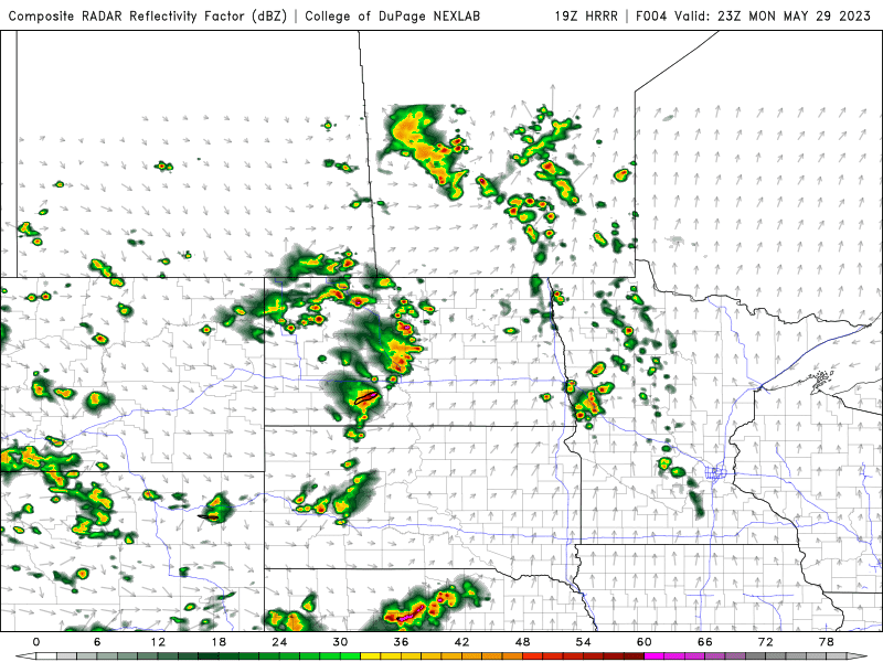
Monday (Above): Today we will see increasing cloud cover as cold front and stationary front approach the red river valley, areas in southwestern Manitoba are already seeing scattered showers and thunderstorms in the region. Mainly non severe thunderstorms are possible spreading into the red river valley and southeast Manitoba as marginal instability builds into those  regions, there is a risk of severe thunderstorms as well in all areas of the south however lower than 40% chance. Temperatures in the red river valley, southeast will remain mild with high temperatures in the mid to high 20’s. A few areas may be as warm as 30C or so, its possible Winnipeg may see its 5th day of temperatures above 30C. Areas only reaching the mid 20’s in the southwest and western part of Manitoba due to convection.  Tonight convection should weaken as the sun sets and overnight low temperatures will for the majority of our region drop into the low to mid teens for southwest Manitoba. Areas in eastern Manitoba will see lows in the mid to high teens. 

Tuesday: Another round of unsettled weather is possible as a cold front moves through in the afternoon hours in the red river valley, this frontal system will encounter higher instability values of 1,000 to 2,000 J/KG. in the red river valley and southeast Manitoba. Scattered non severe and potentially severe thunderstorms are possible with large hail and damaging winds. However nothing organized looks possible due to lack of moisture and shear present. Not everyone will see a thunderstorm due to the very scattered nature of the storms. Temperatures will again rise into the mid to high 20’s with most areas being again close to the 30C mark. Tuesday Night: Any storms left over should clear the province as the system moves into Ontario, temperatures will drop into the low to mid teens for the majority of the region. A few areas may see overnight lows around 15 or 16C. 

Wednesday: A calmer weather pattern will move in for us as we start seeing a more stable weather pattern for us for the second half of the week despite there being low pressure systems in our vicinity. There will be showers and thunderstorms as a possibility in central Manitoba, but that won’t affect the rest of the region. Temperatures on the day Wednesday will rise into the high 20’s across the south. Areas in the interlakes seeing highs in the high teens or low 20’s. Wednesday night: Calm weather continues with lows in the low to mid teens. 

The second half of the week: Another round of unsettled weather is possible as more instability builds in with high temperatures in the mid to high 20’s and low 30’s returning, more low pressure systems will also move through this airmass so we will have to watch for severe weather if it develops. 

Wednesday, May 24, 2023

Hot weather arriving, chances of multiple rounds of showers and thunderstorms

 Get ready folks, southern sections of Manitoba will be experiencing a switch over to hot and dry weather over the coming days, a persistent ridge over the canadian prairies and a trough on the east coast and off the west coast of california will allow for heat to move in and stay for the course of the next several days. This pattern is stubborn as the upper level winds dont want to change much. As well due to a lack of persistent winds from the gulf of mexico there wont be much in the way of humidity, this makes for a complicated forecast as systems are set to move over that ridge bringing multiple rounds of showers and thunderstorms, but some areas may not see this happen at all. This blog will look at this upcoming pattern. 

Heat Incoming!!!! Hotter weather is on the way for Friday and it is coming earlier than average, enjoy these well above average temperatures (which are 10 to 15 degrees above normal) Wooo!!

Wednesday Night: Today much of our region including areas of central Manitoba are dealing with hazy conditions from wildfires in Alberta, the good news is that a large portion of Alberta is no longer being influenced by significant fires there still is some burning but not to the extent where it was last week. Today expect scattered showers over southern sections of Manitoba with, a small cahnce at thundershowers. Temperatures today will go from being in the mid to high teens, into the low teens and high single digits tonight.


Thursday: On Thursday the humidity will increase likely, dewpoints will go from being in the high single digits to the low teens. A frontal system will stall out in western Manitoba, with that frontal system a warm front will be draped over southwestern Manitoba that will occlude and then with the cold front over western Manitoba during the afternoon and evening in Swan River and the parklands regions. Ahead of it CAPE of 1,000 to 2,500 and SRH values between 100 and 250 present posing a risk of severe thunderstorms and weak supercell thunderstorms. As there will be a ridge in place as this storms form, instead of a gradual east movement, expect these storms to move northeast and weaken as they do. There will be inital risk of supercell thunderstorms scattered in nature before storms congeal into a line by mid evening. Severe weather threat areas appear to be from Dauphin north to Swan River, eastwards and northeastwards with large hail and damaging winds as the primary threats. General amounts of 5-15mm are likely. Temperatures will take a soaring on Thursday with places seeing high values soar into the high 20's and low 30's, the highest values will be in southwest Manitoba, and the parklands.

Thursday Night: Expect showers and thunderstorms to continue in the parklands and northern interlakes regions. Showers will be likely for the remainder of the night as they weaken. Overnight lows will be mild with most areas likely seeing lows as warm as the high teens and low 20's in the west and areas further west in the mid teens. 


Friday: The same weather setup presents itself with more humidity and moist air coming up from the western USA and Gulf of Mexico, dewpoint temperatures will return in our region into the mid teens, to high teens in western Manitoba. A frontal system will sit over western Manitoba. Another round of severe weather will present itself this time from the parklands into the interlakes regions of Manitoba, and areas mainly along a line northeast from Dauphin south to Minnedosa, east to Eriksdale and north through Ashern and Arborg into the north side of the south basin of lake Winnipeg. The CAPE values are forecast to be in the range of 1,000 to 2,500J/KG, SRH between 200-300 may support some supercell development initially in the areas of Dauphin and in the parklands followed by a weakening trend with showers and thunderstorms scattered in nature with large hail and damaging winds as a threat. From then onwards they should move ENE with the upper flow. Temperatures for the day on Friday will rise into the mid to high 20's in areas north of Dauphin including Swan River, with areas further south and east experiencing the brunt of the heat with values as hot as 30-32C in the red river valley, southeastern Manitoba, eastern Manitoba.  Areas of western and extreme southwestern Manitoba will see highs in the mid to high 20's. 

Friday Night: Another round of active weather may come in from Saskatchewan during the overnight into the parklands with showers and thunderstorms a possibility. Another area of convection may sneak up from the USA border in southwestern Manitoba on Friday overnight. However that may not happen until morning. Clear skies are likely across the south except ehere thunderstorms are occurring. Overnight lows in the mid to high teens are likely, getting warmer as you move east of Neepawa and Brandon. 


The Weekend (Above): An unsettled pattern will continue with chances of showers and thunderstorms continuing, where that will happen is still yet to be determined. The frontal system as mentioned will move east with additional areas of low pressure impacting southern Manitoba. There is some signs that the red river valley and eastern Manitoba may start seeing convection especially based on the ECMWF model. Ill be keeping an eye on that pattern. Temperatures will likely remain warm with values in the mid to high 20's and low 30's overnight lows will also drop into the mid to high teens, with areas in the west seeing lows in the mid teens. 

Details for next week remain unclear, however there will be multiple chances for thunderstorms with the heat and humidity dissapearing as well as the trough begins moving east with the ridge ahead of it flattening. Another update coming on Saturday!

Saturday, May 20, 2023

Warmer than average Long Weekend, first Hot weather of the season arriving.

Welcome to the victoria day long weekend, southern sections of Manitoba will likely see the warmest weather this year as well with above seasonal temperatures returning. Our overall pattern is drier than average right now and that may change as we get into the second half of the weekend. High pressure will dominate the picture, however smoke may likely make a return as the wildfire smoke shifts. There is a sign that the heat will really ramp up by the end of the weekend, will that lead to more storms? Find out. 


Saturday: Will be a very nice day, as it has been already. High pressure will be off to our south, the only concern is wildfire smoke which will be moving through our region from north to south with more of it forecast to come through by this evening. Temperatures will likely soar into the mid to high twenties across the south, with the warmest of that air centred over the red river valley with a high of 27C in the Headingly neighborhood. Skies will be hazy as a cold front moves through from the north part of Manitoba into southern sections this evening. Tonight: southern Manitoba will see northwest winds which may bring in smoky conditions, overnight lows will drop into the high single digits in southwestern Manitoba 8-10C. Areas further east in the red river valley and eastern Manitoba will see lows in the low teens (10 to 14C). 

Sunday: Another beautiful day is likely on Sunday, with a wind ENE to northeast wind in place a low pressure system will be sitting off to our south. Temperatures will rise into the low 20’s to mid 20’s across the south. Sunday night: A warm front will move through, the overnight period shifting our winds to the south. As a result our temperatures should stay warm with our values for once as warm as 10-14C across the south but as far north as the Pas, even though I don’t forecast that far north it is something to be aware of. Also as winds shift out of the south smoke will move into central and Northern Manitoba. 

Victoria Day Monday: This is when the weather pattern will begin to shift, southern sections of our region will experience southerly winds between 35-50km/h, with weaker winds in the Brandon and Neepawa regions. Sunny weather will end up across the south, high temperature values will approach or surpass 30C. Humidity may be lower at this point in time because of the lack of high dew points suggested to only be 10-15C and then below 10C later in the day. If you are in the northern interlakes however showers and possible thunderstorms are a possible occurrence. Monday Night: Overnight low temperatures will drop only into the mid to high teens (15 to 19C) there is a chance Winnipeg may see its first overnight low near 20C this year. Areas in the parklands/interlakes may only drop into the low to mid teens (10 to 14C). 

The week ahead: Our temperatures will sit in the mid to high 20’s, and possibly above 30C, with overnight lows in the mid to high teens.  A more unsettled weather pattern is likely this week for showers and thunderstorms especially on Tuesday. Too early to know the exact details of this yet. Also as the 500MB winds over western north America change severe weather is possible as a trough develops over the western Canadian prairie provinces and a ridge over the west central united states, this would put us in a favourable position for Gulf of Mexico moisture to stream northwards. Lately that pattern has been nonexistent because the United States has been cooler than average in the south, however the gulf should begin opening up northerly flow soon. This pattern will likely continue into June but with dry periods as we approach the wetter season. According to world weather there is a chance this pattern will continue into June. Seasonal outlook for June is below. Temperatures and Precipitation in a graphic. Link to the article here: https://worldweather.cc/cron_jobs/images/2023/05/07/canada_prognostic_050823.pdf  


Have a great long weekend!! - Mike McGregor

Featured Post

Unsettled weather returns to Manitoba, severe weather risk returns

 Southern sections of Manitoba will be seeing a return to wetter than average conditions with the possibility of severe thunderstorms thanks...