Monday, June 10, 2024

Seasonal weather continues, heat and humidity arrive briefly. Severe weather threat possibly arriving midweek.

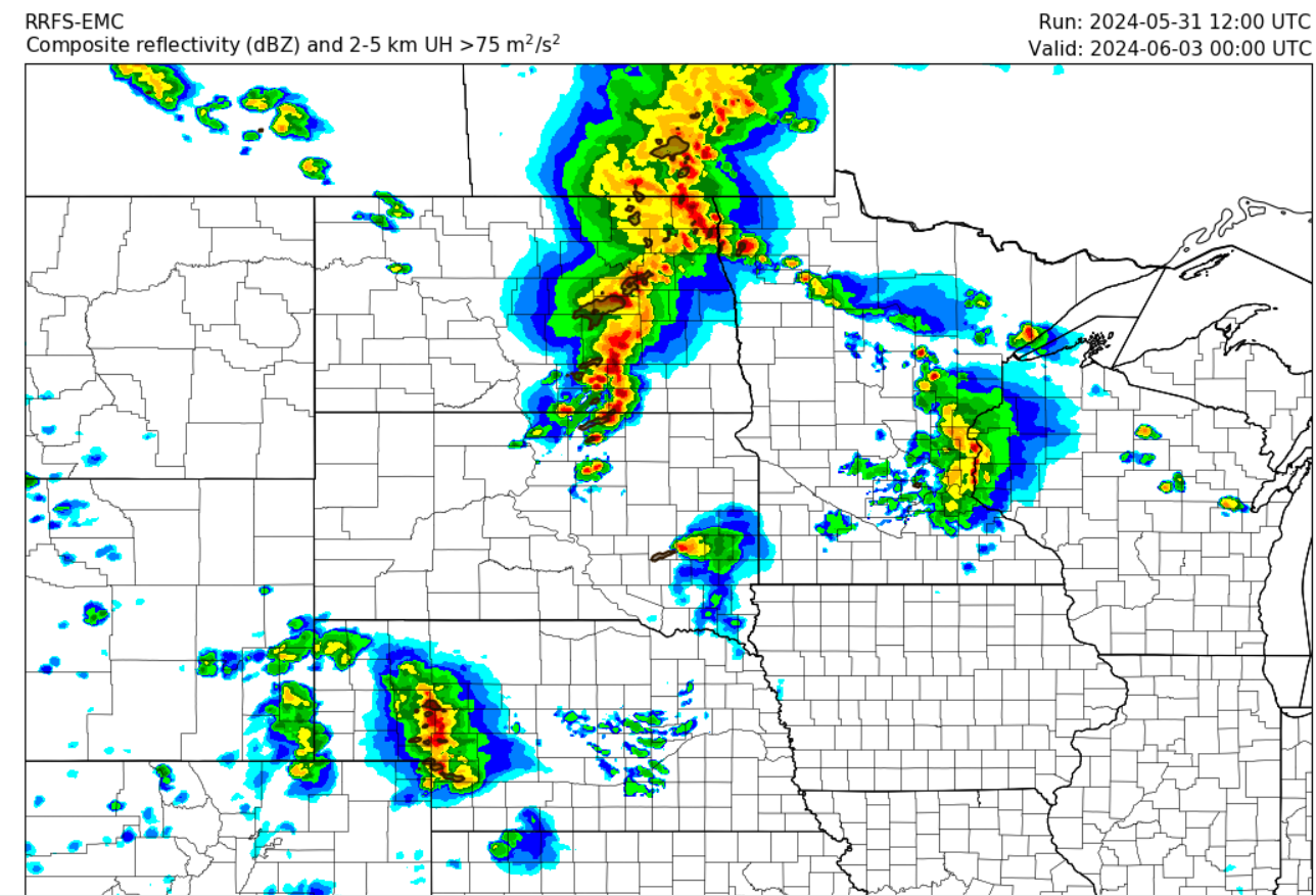
Good evening everyone I have a weather blog update for the weather for the beginning part of the week there's some interesting weather forecast with the potential for some severe weather on the day Wednesday afternoon will get into that shortly. Looks like a broad area of low pressure will be swinging through the central and eastern Prairie provinces with the possibility of bringing with it some unsettled weather and temperatures around normal. 


Above photo of severe thunderstorm risk on Wednesday (Top Photo) followed by the NAM weather model on the (bottom photo) showing the SKEW T Graph threat of severe thunderstorms on Wednesday just South of Winnipeg this may also change depending on the updated model runs over the next 24 to 48 hours.

Tonight an area of low pressure will be moving through southern sections of Manitoba with the possibility of mainly cloudy skies and mostly rain heading into the overnight. General rainfall amounts expected to be between, 10 to fifteen millimeters of rain the most rainfall is likely to fall in southwestern parts of Manitoba up into the Manitoba Scarpent and the east part of western Manitoba near Riding Mountain National Park. By morning a majority of the rain should be out of the province there should be a possibility of showers in the Interlake region as the area of low pressure begins To move SE. Temperatures tonight will drop into the mid to low teens areas of the Interlakes and expect to be seeing temperatures closer to the 10 degrees Celsius marked with the cooler lake waters in those areas.

The weather on Tuesday afternoon should clear out with sunny skies forecast temperatures getting into the upper teens and lower 20s especially if you're in areas closer to the American border. There will be a chance for some scattered showers and weak thunderstorms during the afternoon with very little instability in place expect them to be non severe in nature. A more robust chance of thunder storms are possible on the day on Wednesday. Tuesday night looks like a warm front will approach our region ahead of it there will be a chance for some weak showers or scattered showers during the morning hours overnight low temperatures will be in the mid teens with areas of the Inter Lakes again seeing temperatures in the lower teens.


On Wednesday this is when the weather gets concerning a area of low pressure will be off to our north another one be moving through southeastern Manitoba into northwestern Ontario. Temperatures Will be rising into the mid it to high 20s especially in areas of the Red River Valley and Southeastern Manitoba, along with it high levels of instability. We are generally looking at convective available potential energy values between one thousand five hundred and two thousand five hundred along with Bulk shear between 25 and 45 knots. It looks like the threat for severe thunderstorms will develop during the afternoon and evening in south central and eastern Manitoba there is also a possibility that this risk area could shift a bit further to the West depending on how far east the frontal system decides to move on the day Wednesday. There is an indication during the afternoon that thunderstorms will develop in southwestern Manitoba moving east into the more unstable air mass there will be a possibility of tornadoes happening during the afternoon and evening hours. The risk will be low for tornadoes however. I've looked over several models and the super cell composite as well as significant tornado parameter are on the lower end which shows that there is a slight risk for tornadoes. Areas included are from Brandon to Winnipeg, east to the whiteshell then south to the american border. Also we're not looking at anything that would be considered a more substantial level which you would get in July or August. Bottom line if storms can hold off till a little bit later in the day they may be a little bit more significant however they look like majority of the storms will fire shortly after lunchtime or in the early to mid afternoon hours with very little capping in place these storms may not reach the significant levels that we get in the United States. Regardless look for a risk for a severe thunderstorms on the day Wednesday with large hail damaging winds and torrential rain. Will also be quite humid our humidx values will likely reach the mid 30s during the afternoon on Wednesday. Justin or I will have a updates on this weather threat on the morning hours or late morning early afternoon on Wednesday.


Calmer weather is likely for the second half of the week with temperatures in the upper teens lower 20s possibilities of mid 20s as well, there will be a chance for some showers on Thursday followed by calmer conditions on Friday. However more unsettled weather is likely for the weekend as more areas of low pressure move into southern Manitoba with more instability coming in from the United States, it looks like this is a start to what could be our storm season as June is a more active month on average.
Friday, May 31, 2024

Beautiful weekend to end on Unsettled note, chances for showers and thunderstorms.

 Hello everyone I am back with your weather update for the next 3 to 5 days, I've been quite busy over the last two and a half weeks I was also sick and down for the count with the old C19 virus I am able to provide a quick little synopsis about what's expected with our weather over the next few days especially as we head into the weekend the weather looks turn a little bit more unsettled and we could also have our first shot at More significant thunderstorms. Read on to find out more in this weekly weather blog from yours truly Mike McGregor.


Above window, simulation of the wind gusts associated with the thunderstorms this evening. Severe weather, is not likely. 

The situation for today's weather pattern is we have a trough of low pressure or shortwave off in southwestern Manitoba which will kick off scattered showers and thunderstorms during the afternoon and early evening which will then move east throughout southern parts of Manitoba into the white shell by the evening. These scattered showers and thunderstorms will not be severe however given the fact that we have very strong winds at upper levels that these thunderstorms will tap into that and there is a possibility that some of these thunderstorms could have gusts from 80 to 90 kilometers an hour at times. Given the fact that there will be very little instability to work with these thunderstorms may only produce five to ten millimeters of rain once they impact your location. I coordinated with Justin with some information on this setup and he says that if any thunderstorm does impact the location it could have some very strong wind gusts there is a very low risk of hail associated with these thunderstorms. Regardless I'm seeing a likelihood of our high temperatures soaring into the low 20s for a majority of southern Manitoba once these thunderstorms move through during the late afternoon hours especially in the southwest these temperatures will drop well into the mid teens.


Tonight: as this shortwave moves back to the West in southern Saskatchewan I'm not seeing any significant weather moving into the rest of Manitoba during the overnight, remaining showers and thunderstorms which developed will likely be impacting the white the white shell and eastern Manitoba shortly before midnight. Areas to the west of the trough of low pressure especially in southwestern Manitoba will only see low temperatures between five and 8 degrees Celsius, areas to the east of the Trough of low pressure will see temperatures drop which is more seasonal for this time of year between 10 and 14 degrees Celsius areas that are in rural Manitoba may see temperatures closer to 10 degrees Celsius.

Saturday looks to be gorgeous with our daytime high temperatures soaring into the high teens and low 20s, mainly sunny skies are likely during the afternoon with Winds out of the West between 10 to about 30 kilometers an hour. No significant weather to talk about. 

Saturday night will be the transition as an area of low pressure sits off to our South in the North Dakota's, this will be our weather maker for Sunday. Expect an area of increasing cloud cover with a possibility of some cloudy patches during the morning hours, Overnight low temperatures are likely to drop into the low to mid teens there is a possibility that some urban centres may be a bit warmer winnipeg is forecast to get a low of 16 degrees Celsius whereas areas outside the city may see temperatures between ten and fourteen degrees Celsius.


(Above): Thunderstorm complex likely to impact southern Manitoba on the day Sunday. We will let you know further updates as they come in.

Sunday: OK this is the one the weather starts to get a wee little bit Interesting and I've decided to use a little bit of some England accent to start this synopsis for Sunday, I promise you we're not gonna be getting weather that they would get in the United States or their countries what you would call monsoons. A strong frontal boundary looks to impact southern sections of Manitoba during the day on Sunday out ahead of it strong precipitable water values between one to 1 1/2 inches is possible which will be fuelled along a strong low level jet boundary and a general ML capes between five hundred and a thousand will be accessible for these thunderstorms. Models are suggesting a thunderstorm complex developing out ahead of a large broad trough that is sitting over northern Manitoba, only areas seeing that risk is in southeastern and S central Manitoba the highest risk for severe thunderstorms appears during Sunday afternoon and evening. Based on the latest data it appears that thunderstorms will be developing in northwestern North Dakota filling into southwestern Manitoba by the late afternoon hours there is a possibility that depending on where the front lines up that these thunderstorms could fire further to the south if that happens the thunderstorms could be impacting only areas of southeastern Manitoba including the Red River valley and the Winnipeg Interlake regions. Justin I Justin and I had a conversation and it appears that we could have be having a decent risk of another round of severe thunderstorms on Sunday as mentioned a few moments ago. The details of this event are still being ironed out by high resolution models so we will update you on the afternoon or evening on Saturday for this event. Regardless our high temperatures on Sunday will be rising into the mid to high 20s the majority of the Red River valley will be seeing high temperatures in the upper 20s with humidity or humid arcs values likely in the mid to high thirties.

Sunday night/ Clearing is likely with temperatures behind the front, dropping into the low to mid teens. Cloudy to partly cloudy skies are likely overnight . 

The week ahead: Showers and storms are likely during the first half of the week with some remaining unsettled weather conditions. Storms are possible again on Tuesday though likely non severe in nature. Temperatures will remain seasonal with highs in the low to mid 20’s. Overnight lows in the mid to high teens. 


Wednesday, May 15, 2024

Wild End to the Week Likely, first severe thunderstorm threat arriving for the season. Will This wet weather Continue?

 Hello folks of southern Manitoba, And Hello all loyal blog followers. I am back with an update on the weather for the end of the week. Yes you read that right there appears to be our first threat at severe weather over southern sections of Manitoba heading into our end of the week. To end the week we have large scale trapping over Western Canada which is allowing for the development of low pressure systems over the southern Prairie provinces. A wetter then average trend continues to be taking over our weather story for the second half of the week we will have details on everything you need to know about this. Starting off with a less traditional way of doing my blog posts I have attached a photo below of the total accumulated rainfall that is forecast by the ECMWF AI vs the NAM weather model and this is pretty interesting that it is showing a convective event a couple of days of in advance will have a little bit more about this below. 


. This weather blog will cover the forecast into the weekend and early next week...

I know I have lots to talk about but we're gonna start off with details on our weather for tonight,

Tonight: Much of southern sections in Manitoba will continue to see scattered showers especially areas in southeast Manitoba as a weak shortwave moves through into northwestern Ontario during the overnight. Cloudy skies are expected during the overnight with some clearing in south central and southwestern Manitoba. Temperatures during the overnight will more than likely stay above 10 degrees Celsius for portions of the red river valley and southeastern Manitoba with values between 10 and 12 degrees Celsius, areas further to the west under clear skies will likely see overnight values between 5 and 8 degrees Celsius. 

Thursday: Southern regions including Western Parklands area of Manitoba could be in for an interesting day on the day Thursday, a stationary front is forecast to stall out on the western side of Manitoba during the late afternoon. Based on current model consensus a majority of southern sections in Manitoba. The risk for showers and weak thunderstorms with the highest risk in western Manitoba, general CAPE values appear to be between 300 and 700 joules per kilogram the strongest signals for thunderstorms appear to develop over Western Manitoba and then the interlakes towards later in the day. Storms will be scattered in nature and they may bring a risk for small hail. Although environment canada is forecasting thunderstorms for all of southern Manitoba, I do not see a significant risk for severe weather. Temperatures during the afternoon will rise into the mid to high teens, with eastern Manitoba a bit cooler in the mid teens as a possibility. 

Thursday night: This is when the transition starts before and more active setup occurs on the day  Friday, a stationary front will remain over Western Manitoba where scattered showers or possible weak thunder showers will continue during the evening hours before weakening again I see the best risk area for thunderstorms off and on throughout southern Manitoba during the evening scattered and very localized in nature. Overnight on Thursday mostly cloudy skies are forecast with the exception of extreme southern Manitoba near the American border where clouds will likely clear towards the morning hours. The upper level flow will continue to be out of the southwest. Temperatures in the southwest will be remaining above or around 10 to 15 degrees celsius overnight areas further to the east will likely see overnight lows in the upper single digits.


Friday night (simulated radar above): This is when stronger jet stream upper level winds will enter southwestern Manitoba during the afternoon this will gradually move to the east throughout the day a strong southwesterly level flow will occur. For those wondering this is the weather event that prompted my title for the blog and I am actually not surprised considering that this is Manitoba we will be expecting our first round of severe thunderstorms possible on Friday and Friday evening. It appears that our temperatures on Friday will be a lot warmer compared to earlier in the week where our high values could soar into the high teens low 20s in some areas of the southwest and Red River valley could rise into the mid 20s during the afternoon with humidity values pushing the thirty degrees Celsius Mark . In regards to the details of this event are still being figured out in weather models there are still some specifics about the location and timing however current model runs now show a warm front just sitting south of the border during the afternoon which will lift N during the evening and as strong low pressure system also sit there which will draw in strong levels of moisture from the United States. If you're wondering what I mean about moisture I see our dew point temperatures rising into the mid teens in the Red River valley and eastern Manitoba which is more considered to be something you would see in mid June or early July, there will also be a increased level of Cape which is basically what provides thunderstorms to have fuel to run on. The levels will be between 1000 to 2000 joules per kilogram the latest NAM model at 18Z appears to show a stronger area of shear and instability just to the west of Winnipeg. Based on what I am seeing this could very well be our first decent chance of seeing strong to severe thunderstorms developing, however depending on the cap storms could either start developing in northwestern North Dakota traveling northeast into the Pembina and Red River valley areas into the Interlakes, there is also a likelihood of thunderstorms developing ahead of this along the warm front in the Red River valley and Interlakes. There is also a chance storms dont form at all with the cap in place. Overall this setup does favor strong to severe thunderstorms being a possibility over all areas of the Red River valley eastern Manitoba Interleakes with a slightly lower risk for western portions in Manitoba depending on the frontal position at the time. What this means is convection will likely develop in south central Manitoba or northwestern North Dakota but this is all dependent on a cap which may hinder storms from developing during the afternoon and evening hours we'll see if this setup changes by any means . There is also a very low chance of seeing tornadoes developing during the evening hours we will monitor this if there is any changes to this outlook but please make sure that you're able to stay tuned to alerts and warnings when possible could be something that needs watching. I will have a update on Twitter and on the weather centre of Manitoba in regards to this setup and the outcome on Friday afternoon there will also be a bit of information posted in the comments section which is something that will be done more as we approach what could be very well a busy storm season.

Friday night: It appears that if any thunderstorms form they will likely move into eastern Manitoba and northwestern Ontario during the overnight. With a possibility of more thunderstorms on the day Saturday specifically during the early morning hours as the cold frontal passes through. Temperatures actually will remain quite mild on Friday night with overnight low values in the mid teens. Areas a bit further to the West and the WestMan and Parkland regions will likely see overnight low values in and surprisingly quite cool for this time of year with values in the upper single digits. 

Saturday and Sunday: The weekend appears that it could actually be one of those cooler weather days especially Saturday where high temperatures will only rise into the low to mid teens, mostly cloudy skies are likely as you travel into the interlakes regions where high values will only be between five and 10 degrees Celsius. I do think the NAM model however is slightly inaccurate in forecasting values I do believe they will be a bit warmer considering some areas may see Sun during the afternoon which may help increase the level of daytime heating. The second half of the weekend should be much better with sunny skies forecast on Sunday and our high temperatures in the upper teens some areas may approach 20 degrees Celsius in regards to overnight low temperatures expect the average values of mid to high single digits with some areas seeing overnight lows around 10 degrees Celsius. However the cutoff for these temperatures appears to be over the Manitoba Lakes where the lakes water temperatures are still at least cooler or near average this time of year with shores along the lakes could be seeing temperatures between one and five degrees Celsius.

Friday, May 10, 2024

Showers and Thunderstorms Possible On Saturday, calmer weather to follow

Hello Manitobans This is another weather blog update for your weekend weather, We may have an interesting weekend ahead for weather southern sections of our province will be experiencing a many heat wave as a result of an incoming area of low pressure. This will make for the first of what is likely many days of summer weather ahead, There is a possibility of seeing our first decent chance of seeing scattered showers and thunderstorms find out more in this weekend's weather blog. 


Southern sections Manitoba will likely  see high temperatures on Saturday rising well into the 20s there is a possibility that areas specifically at the Red River Valley and southeastern Manitoba may see values between 25 and 30 degrees celsius this is dependent though on how much of a southerly flow we can draw in ahead of the low pressure system in the warm sector. The low pressure system that is impacting southern sections of Manitoba will move through during the late afternoon hours a general 500 to 800 joules per kilogram of Cape looks to be in place, initiation may take place depending on the timing of the fronts either in southeastern Manitoba or over the Manitoba Lakes. Some model runs had thunderstorms developing over the southern part of Lake Manitoba and moving through the Red River Valley newer model runs now are suggesting thunderstorms developing just to the east of Winnipeg. However Environment Canada still has a 60% chance of seeing showers with the risk of thunderstorms for areas of the Red River valley there is a possibility that areas further west in western Manitoba may also see thunderstorms developed during the afternoon instability along the fronts remains to be quite low however there will be a good chance regardless for some rural parts of the province to see scattered showers or thunderstorms mainly non severe nature. Environment Canada did mention that there is a possibility for a rogue severe wind gust or two however that does not look like it will be a significant concern for the afternoon with thunderstorms that develop.

Saturday night mainly with clear skies are forecast and a awesome overall temperature trend will likely continue with our overnight lows dropping into the low teens for areas of southeastern and south central Manitoba, a little bit further to the west areas in western Manitoba including the parklands maybe a bit cooler with overnight lows in the upper single digits.

Sunday: Beautiful sunny skies are forecast for a majority of our region and a little bit cooler though that is good because we had a little bit of a heat burst forecast on Saturday, General Lee high temperatures are forecast to be in the upper teens and low 20s. Generally areas north of highway one will only see high temperatures in the mid to high teens areas further north maybe closer to about 15 degrees. 

Sunday Night: Much of southern Manitoba is going to be experiencing a colder air mass on Sunday night with a majority of our lows actually dropping closer to the normal temperatures we see in April or March with lows between two to five or six degrees. The good news is that mainly clear skies are forecast during the overnight. 


Moran settled weather conditions are possible during the first half of the week with high temperatures continuing to remain seasonal mainly in the high teens and low 20s and overnight lows in the upper single digits and low teens, there is a possibility for more shower thunderstorm activity during Tuesday into Wednesday we will know more by the beginning of the week.


Friday, May 3, 2024

Warmer weather and sunnier conditions on the way, possible change to wetter conditions for the coming week

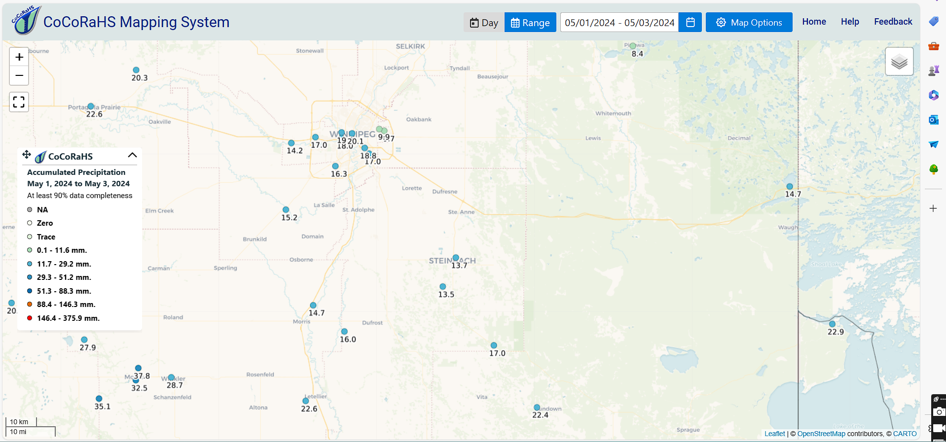
 Hello folks of southern Manitoba and those weather watchers in the southern part of the province we have an update on the weather for the weekend into early next week we'll see if we can add some information about the weather into the 2nd half of the week. On the heels of a low pressure system which impacted majority of southern Manitoba over the last couple of days is now moving into northwestern Ontario behind it a large area of high pressure will develop which will bring us slightly cooler temperatures to start the weekend however as we get into start the week it appears that we could have a return to warmer than normal conditions. Bottom line of beautiful weekend is more than likely to happen for us. In regards to the amount of rainfall that received areas west of Winnipeg received between 20 and thirty millimeters rain areas of southeastern Manitoba also picked up about 20 to twenty five millimeters of rain areas further north including the Interlakes only picked up about 10 to fifteen millimeters of rain and areas of the southwest also picked up similar amounts. I have attached three photos below with information on where the heaviest rainfall occurred from the CO CRAHS maps.


Saturday: High pressure looks to impact the majority of our region during the weekend specifically Saturday and Sunday could be some of the nicest days we've had in a long time, sunny skies are likely with high temperatures for majority of our region reaching the low teens and some areas may get close to the fifteen degrees celsius mark.

Saturday Night: Southern sections in Manitoba will be in a much cooler air mass on Saturday night as well mostly clear skies are likely however there is a possibility of fog patches developing in the Red River valley the good news is that this will not persist. There is also a low risk of frost for areas of The Western escarpment and areas around the Manitoba Lakes. Temperatures for a majority of the region will drop into the low to mid single digits.

Sunday: This will be one of the warmer days of the weekend and I'm actually kind of surprised with the latest model data suggesting high temperatures in the high teens for a majority of the our region especially if you're gonna be closer to the American border some areas could receive or at least get up to about twenty degrees Celsius this is something we have not seen in a couple weeks. The warmest of the weather is also likely to continue as we head into the week details on that below. 

Sunday Night: Overnight low temperatures will likely stay warmer again during the overnight. Sunday instead of seeing our little values drop closer to zero our low values will drop closer to the 10 degrees Celsius mark so that's a switch up from what we are forecast to see on Saturday night.

The week ahead: it looks like much of southern Manitoba will be in a warmer temperature pattern however a little pressure system is expected to impact southern Manitoba during the day on Tuesday through Thursday,  There is a possibility however that this system decides to move W further into Saskatchewan and Alberta there is a possibility that this may change depending on where the position sets up but a majority of the rain is likely to impact the Western prairies.We're still figuring out the details about this system. If the forecast changes and we get rain for our region during the week it'll be welcome news for our farmers. 

Monday, April 29, 2024

Cooler Weather Trend On the Way For Southern Manitoba, rain and wet conditions also likely this week.

Hello Folks I know its been a while since I last posted a blog I have been busy with moving and I also had to get over the flu a few weeks ago. I am back and better than ever though. I will have quick details for you all on the upcoming week ahead for our weather pattern. 


Rainfall accumulations as forecast by the NAM model, a general 5 to 10mm of rain is likely before another batch moves in to our area on Thursday. 

Tuesday: Southern Manitoba will be on the verge of another area of low pressure which will enter the region and during the evening hours, most like cloudy skies will likely be in place throughout the afternoon and evening. Precipitation including rain will move into areas of southwestern Manitoba late in the afternoon. Temperatures during the afternoon on Tuesday will soar into the high single digits and low teens the warmest of the weather will be across the south except for areas of the far northern eastern and western side of Manitoba . Tuesday Night: Rain will begin moving across southern Manitoba into far central regions during the overnight hours, there will be some regions in western Manitoba specifically by dauphin and Swan River that could experience periods of snow during the overnight hours. A general 3 to 5mm of rain is likely in all areas of the south except areas of the southwest part of Manitoba where 5 to 10mm of rainfall is more likely overnight. Temperatures on Tuesday night will drop into the low to mid single digits with the majority of the region seeing low temperatures between one and five degrees Celsius.

Wednesday: During the day on Wednesday the rain which we experienced on Tuesday night will Will move north along with a frontal system into northern sections Manitoba, areas of southern Manitoba will start seeing increased levels of instability with a possibility of seeing thunderstorm energy values between 300 to 700 joules per kilogram there is a possibility of seeing weak garden variety thunderstorms in a scattered nature across southern sections of the region towards late afternoon areas at higher highest risk right now appear to be southwestern Manitoba portions of the Red River Valley and the escarpments of Western Manitoba by Riding Mountain National Park. This may change depending on the frontal system that is forecast to move through on Wednesday. Temperatures on Wednesday for majority of the South will likely be in the upper single digits and low teens areas north of highway one for Central Western Manitoba the Interlakes and Central Eastern Manitoba will only see high temperatures in the mid to high single digits.

Wednesday night: A low pressure system developing is forecast to move into southern Manitoba with a wide swath of rain areas all areas will be impacted by this overnight as a system lifts into our region, The majority of the rain will be impacting our region by Thursday morning expect scattered showers with mostly cloudy skies during the overnight. Into the morning is when majority of the rain should start falling for a region between the saskatchewan/Manitoba Border and Winnipeg areas further east may not get impacted until later on the day on Thursday. By the morning hours areas of southwestern Manitoba will have received between 3 to 5millimeters of rain. Overnight low values will likely drop into a fairly mild overnight roll considering the last few nights will be a lot colder I'm looking at values between five and 10 degrees Celsius during the overnight mainly from a swath from From Pilot Mound to Winnipeg N into Gimli and SE into Sprague areas north of that will see overnight lows in the mid single digits.\

The second half of the week: Looks like unsettled weather weather will continue with rain persisting as a result of troughing over the Canadian Prairie provinces which will contribute to more rainfall accumulations by the end of the week we will know more on this low pressure system by Wednesday afternoon I will have another weather blog update on Thursday to detail this weather system that's coming in for our end of the week into the weekend which will hopefully experience some calmer weather conditions towards Friday.


Monday, April 15, 2024

Major Rainfall first of the season for Southern Manitoba.

Hello folks of southern Manitoba this is another weather update, we have some interesting weather on the way a low pressure system developing in Colorado will be moving into southern portions of Manitoba including areas in the north even though that I do not cover that forecast area there is a chance for some significant snowfall in areas of northern Manitoba and portions of Western Manitoba and eastern Saskatchewan. This is the first of hopefully many low pressure systems to deliver moisture to desperately needed areas especially areas in the South that experience a drought this past winter. Read on to find out more about the weather impacts that are forecast with this low pressure system. 

Rain forecast to impact areas of southern Manitoba, system is going to impact the region. 

*Please note that forecast for temperatures will not be mentioned in the daily outlook they will be mentioned at the bottom at this post to allow for more clarification on snowfall and precipitation patterns for this forecast system.*

***This blog may be a little bit shorter than normal I am in the process of creating a playlist for my radio show tomorrow on CKUW so I am in the middle of multitasking but this blog should be sufficient enough for those who are looking for information on the upcoming rainfall expected over our region. *** 

Tuesday: Low pressure system will be off to our S in the United States in North Dakota during the afternoon ahead of it in the warm sector and to the north of the low a wide swathe of rain will begin moving into southern Manitoba starting in southwestern parts of the province from pilot mound to Portage La Prairie moving north east throughout the day by around lunchtime areas of the Red River valley and eastern Manitoba can expect to be seeing rain at times heavy persisting into the evening hours. This rain will basically cover all of southern sections of Manitoba including Western Parklands. Given the fact that this rain will be stalling over western parts of Manitoba for a majority of the afternoon on Tuesday they can expect to see the heavier amounts. If the heavier rain decides to set up further to the east in the Red River valley Pemina Valley and eastern Manitoba amounts instead of 10 to twenty five millimeters will be in the 25 to forty five millimeter range however current forecasts show that areas of the southwest and the West will receive between 20 and forty millimeters of rain areas in eastern Manitoba will be seen between 10 to twenty five millimeters of rain although heavier amounts in convective rainfall. There is a possibility that during the early afternoon to mid afternoon there may be a chance at seeing some thunderstorms but that chance appears to be very slim and only areas of the Red River valley and over areas by Lake Manitoba appear to be at the highest chance expect only a couple rumbles of Thunder as a possibility.

Tuesday night: a cooler air starts wrapping in behind the system bringing a possibility of snow mix with rain mainly areas of The Red River valley points east into eastern Manitoba areas south of highway one also have a possibility of seeing this. It may continue into the morning hours however given the fact that roads will still be warm a lot of the snow will melt on contact. Models are disagreeing on the placement of where the transition to snow and if that happens depends on where the cold air wraps around behind the system. There is a risk that areas from just north of the international border all the way into the interlakes for all of Southern Manitoba will possibly see some slight snow accumulations on Tuesday night. This will not be a significant snowfall by any means as majority of the precipitation is forecast to fall as rain. 


(Rainfall Totals in map shown above)

Wednesday: During Wednesday in the morning hours a broad swath of rain mixed with snow will move through southern ports of Manitoba majority of the snow should melt on contact in urban centres including some rural areas I'm expecting that this rain snow or just plain snow fall will end towards the early to mid afternoon hours. The model that's putting out the highest snowfall amounts is the NAM NEST which is suggesting areas mainly north of Winnipeg into the Interlakes W to Dauphin can expect to see between 10+ centimeters of snow, I highly doubt that this is going to happen for areas South of the Manitoba Lakes in the Red River Valley, eastern parts of the province will escape this with only about one to about nine or ten centimeters possible. 

Wednesday night: It appears that areas of our region will escape the majority of the snow that is expected to hit northern areas., in southern sections of Manitoba will expect to be mostly cloudy or partly cloudy during the overnights winds will be also out of the north making the temperatures quite brisk. There is a chance for some Lake effect flurries or showers during the overnight. The bulk of the precipitation which impacted the region on Tuesday and Wednesday will be in Ontario at the time.


During the second half of the week the low pressure system is forecast to impact areas of northern Manitoba however the effects will be felt minimally in areas of southern Manitoba with only flurries or rain showers of possibility during Thursday and Thursday night Friday will be much calmer as low pressure system moves into northwestern Ontario. 

Temperatures for the period:
 Tuesday expecting high temperatures in the afternoon in the mid to high teens with the exception of Southwestern Manitoba seeing high temperatures in the high single digits, 

Temperatures on Tuesday night will drop into the lower end of the single digit mark areas may escape seeing overnight low values around the freezing mark.

Temperatures on Wednesday will rise into the mid to high signal digit range areas of the southeastern parts of Manitoba will be likely to see the warmer values during the afternoon.

 Wednesday night overnight low temperatures will likely drop into the low single digits in some areas especially in areas of southwestern Manitoba around the zero to minus 5 degrees Celsius mark. Areas east of the Pembina Valley will escape the overnight lows around 0C. 


Featured Post

Unsettled weather returns to Manitoba, severe weather risk returns

 Southern sections of Manitoba will be seeing a return to wetter than average conditions with the possibility of severe thunderstorms thanks...