Friday, July 6, 2012

A Few More Rounds Of Showers and Storms, Before The Heat Starts Building In!

A few more areas of low pressure and chances of precpitation are expected to move through Southern Manitoba over the next couple of days, as the ridge takes a while longer to build in than first thought.                                                                                                    
A look at the probability of seeing precipitation over 2mm for the time period of July 6th to July the 10th. Chances of precipitation range from 50 to 60% for most of the interlake and the parklands region, while most of Southern Manitoba and the Red River Valley will have a 70 to 80% chance of seeing some kind of precipitation.


The Ridge that was previously forecast to form and move into Southern Manitoba this weekend instead it has decided to wait a while and not form for a couple of days, this means we will be stuck in a more zonal flow through the weekend until the ridge starts building. Although that means we will have a chance at more rain than first thought, though it is great news for areas that haven't received much rainfall in the province.
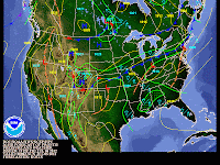
T-storms will clear out by late eve.  
T-storms will start at Noon
The next likely shot at seeing rainshowers or thunderstorms will come Saturday in the Afternoon and in the Evening as another area of low pressure moves Southeast through the regions of Southern Manitoba. Scattered Showers and Thunderstorms will fire up along this system as it moves through the RRV during the late afternoon early evening hours. There won't be a threat for significant severe weather tomorrow afternoon, as the parameters look to be fairly low. However there may be a few storms in the afternoon that could become severe, if it happens the severe weather will be very short lived.

As for our Temperatures they will remain being in the high twenties for daytime high's along with temperatures in the 15 to 20C mark for overnight lows. The real heat will start by the beginning of the week as the ridge starts building, temperatures will rise into the mid to high 30's by the end of next week and into next weekend giving us a great shot of summerlike weather.

No comments:

Post a Comment

Thank's for commenting on the blog, I appreciate it...

Featured Post

Happy New Year, Significant Winds Likely with Blizzard Conditions this weekend. Cooler weather arriving next week.

 Everyone welcome back to a new year in the weather scene hello everyone mike mcgregor here returning for the first post of 2025 and we'...