 Rain from this system will spread into parts of Western Manitoba this evening and it should reach the Red River Valley and Eastern Manitoba overnight, the systems speed will slow tomorrow leaving us with rainy conditions through Monday. Rain will change over to snow over higher elevations of West MB Monday with some amounts likely over the Duck Mountain Provincial Park and Riding Mountain National Park regions. Rainfall amounts of 10 to about 20mm will be possible through much of Southern Manitoba for those needing significant rain it will be an influence through from Western Manitoba as far East as Winnipeg and the Red River Valley. By Monday Night colder reinforcing air coming in from behind the system will allow a change over from rain to wet snow, even in regions of the Red River Valley with a coating of wet snow possible by the morning hours on Tuesday. Below Normal Temperatures in the single digits will join along this week, before warmer (moderating temperatures) next week.
Sunday, October 7, 2012
More Needed Rain On The Way Tonight Through Thanksgiving Monday
An Alberta clipper system now over Northern Saskatchewan will track southwards into Southern Manitoba overnight and through Monday bringing another round of much needed moisture over the region.
 Rain from this system will spread into parts of Western Manitoba this evening and it should reach the Red River Valley and Eastern Manitoba overnight, the systems speed will slow tomorrow leaving us with rainy conditions through Monday. Rain will change over to snow over higher elevations of West MB Monday with some amounts likely over the Duck Mountain Provincial Park and Riding Mountain National Park regions. Rainfall amounts of 10 to about 20mm will be possible through much of Southern Manitoba for those needing significant rain it will be an influence through from Western Manitoba as far East as Winnipeg and the Red River Valley. By Monday Night colder reinforcing air coming in from behind the system will allow a change over from rain to wet snow, even in regions of the Red River Valley with a coating of wet snow possible by the morning hours on Tuesday. Below Normal Temperatures in the single digits will join along this week, before warmer (moderating temperatures) next week.
Rain from this system will spread into parts of Western Manitoba this evening and it should reach the Red River Valley and Eastern Manitoba overnight, the systems speed will slow tomorrow leaving us with rainy conditions through Monday. Rain will change over to snow over higher elevations of West MB Monday with some amounts likely over the Duck Mountain Provincial Park and Riding Mountain National Park regions. Rainfall amounts of 10 to about 20mm will be possible through much of Southern Manitoba for those needing significant rain it will be an influence through from Western Manitoba as far East as Winnipeg and the Red River Valley. By Monday Night colder reinforcing air coming in from behind the system will allow a change over from rain to wet snow, even in regions of the Red River Valley with a coating of wet snow possible by the morning hours on Tuesday. Below Normal Temperatures in the single digits will join along this week, before warmer (moderating temperatures) next week.
Early Season Snowstorm Slams Southeastern Manitoba Head On
 |
| Some of the roads in Southeast Manitoba were virtually unpassable due to slushy snow covered roads, leaving crews with the only choice left, close the roads. Including this highway in the RM of Stuartburn on Thursday. All highways are now open due to improvements in conditions. |
Snowfall Totals From The Storm (via Rob's Blog)
 |
| A great example of where all the snow fell during the storm including places south of the lakes where the lake effect snows took place. |
Hadashville ............ 30 cm (see photo)
Woodridge ............. 30 cm (see photo)
La Broquerie .......... 27 cm
Falcon Lake............ 25-30 cm (est)
Vita ........................ 25 cm
Pinawa ................... 20-30 cm
Bissett .................... 20 cm
South Junction ........ 20-30 cm /nr Sprague/
Steinbach ............... 8 cm
The early snowfall, even though it was an inconvience it brought some very much needed moisture to our region that has been very dry over the past several weeks. The snowfall brought relief to all firefighting efforts, including the one windswept wildfire in the vita area that forced residents to evacuate two days earlier. In Winnipeg 8mm of rain and wet snow was recorded at the CYWG (City of Winnipeg) airport by evening. Across the city 10 to 20 mm of rain was reported, (19mm at the forks) and a good 10 to 12 mm at my place by Bruce Ave in St.James.
A great analysis of past early snowfalls in Winnipeg and in Southern Manitoba can be found at... Rob's Blog
Wednesday, October 3, 2012
Storm System Set to Bring Significant Rain and The Seasons First Snowfall to The Red River Valley And Parts Of South Eastern Manitoba Tonight Through Until Thursday Night
 |
| The Storm System at 12Z (7am) Tomorrow Morning showing rainfall/snowfall rates. |
Additional Information: Environment Canada issued a Winter Storm Warning Earlier this afternoon for Southeast Manitoba highlighting the potential for significant winter weather and hazardous driving conditions in places over the next 24 hours. The expected heavy wet snow with this system may create stress on powerlines and tree branches possibly resulting in localized power outages in some regions. Take Precautions when out on the roads during the expected storm duration. Feel Free to track the Storm as it progresses at the KTIV Interactive Radar Weather Website.
Wednesday, September 26, 2012
Warmer Weather Set To Return To Southern Manitoba
After a prolonged period unexpected cool temperatures and near to below normal temperatures, warmer weather is now on the way for many parts of Southern Manitoba.
 |
| Picture taken from A Weather Moment, note the blue squiggle the advancing upper level ridge. |
The trough that has remained parked over our province the past week will finally be pushing off to Northwest Ontario, allowing the building upper level ridge currently over British Columbia to spread east into Southern Manitoba bringing with it some milder Pacific Air.
With the incoming upper level ridge the chances for precipitation will be slim to nothing over the next few days in the province, leaving conditions in the same way they have been "dry". We will see our temperatures climb into the high teens and possibly above the 20 degree mark in Western Manitoba, though conditions will get a touch cooler as you head east into the Red River Valley and Eastern Manitoba where most temperatures will be in the mid to high teens.
Things will be even warmer for Thursday as a warm front moves through, so temperatures will climb towards the low twenties in many regions. The real heat comes on Friday and the weekend when we will see temperatures in the high 20's in Western Manitoba, and the mid twenties in the RRV and East Manitoba. The warm weather will continue right into next week, giving us a chance to finish off the month in a warm pattern.
Monday, September 24, 2012
Fall Weather To Continue
Fall Has Begun and seasonal to above seasonal weather will be the case for the week ahead, bringing us a taste to the fall season.
Surface high Pressure will be over our region for this week as it slides southwards, bringing cool to warm and dry weather for the period.
For tonight most temperatures will reach the low single digits to below zero, in southern regions of the province. This will make things a touch frosty as we experience perfect freeze conditions before sunrise. However things will warm up for the day tomorrow with daytime temperatures reaching the low to mid teens, before the warmup begins by the middle of the week and persists into the weekend.
During the middle to second half of the week most temperatures will warm into the high teens and maybe the low to mid 20's as we enter the weekend and next week.
Why such warm weather forecast? Well it will be all to do with an upper level ridge that will move over our area at the end of the week shifting our winds to the south, bringing warmer air that has been sitting in the states into our region. This will give us the chance to see above normal temperatures and below normal precipitation to finish off the month. WhooHoo! Summer Weather Is Returning!
 |
| High Pressure will build over our area allowing for dry weather to continue |
For tonight most temperatures will reach the low single digits to below zero, in southern regions of the province. This will make things a touch frosty as we experience perfect freeze conditions before sunrise. However things will warm up for the day tomorrow with daytime temperatures reaching the low to mid teens, before the warmup begins by the middle of the week and persists into the weekend.
During the middle to second half of the week most temperatures will warm into the high teens and maybe the low to mid 20's as we enter the weekend and next week.
Why such warm weather forecast? Well it will be all to do with an upper level ridge that will move over our area at the end of the week shifting our winds to the south, bringing warmer air that has been sitting in the states into our region. This will give us the chance to see above normal temperatures and below normal precipitation to finish off the month. WhooHoo! Summer Weather Is Returning!
Monday, September 17, 2012
Frosty Fall Like Start To The Week
Southern Manitoba will be in for a cold, chilly perhaps even a frosty couple of days to start our week. We will be welcomed by cool daytime highs and sub zero nighttime lows which will make for a overall fall like feel.
 The night ahead is looking like it could be a cold one with most temperatures cooling from 6C in Western Manitoba to about 2C and 0C in the RRV and Eastern Manitoba. The cold Temperatures are making the Regions west of The Red River Valley including areas of the Red River Valley and Eastern Manitoba susceptible to frost. Those wondering why Western Manitoba will be warmer, it is a result of the warmer air that is moving in from the West with the ridge that is in place in Alberta.
Daytime highs will be warmer tomorrow than they were on Monday with most readings getting close to 20C in Western Manitoba, but a little cooler as you go east into the Red River Valley and Eastern Manitoba where temperatures will be stuck in the teens. Definitely warmer than the 10C that was experienced in Winnipeg Monday. Another cold front will sweep through overnight Tuesday into the day Wednesday ushering in another cool arctic airmass to end our week. For Those long range lovers Wednesday through Friday will be cold with temperatures stuck in the teens. Precipitation wise, it will stay mainly dry with no significant chances of precipitation this week, though we may still see some measureable rain later in the week as a few strong impulses rotate through the region.

At this point the longe range forecast looks fairly status quo. We will see some temperature fluctuations, making our temperatures feel near normal and average. It will defintely feel fall like with freezing overnight lows.
 The night ahead is looking like it could be a cold one with most temperatures cooling from 6C in Western Manitoba to about 2C and 0C in the RRV and Eastern Manitoba. The cold Temperatures are making the Regions west of The Red River Valley including areas of the Red River Valley and Eastern Manitoba susceptible to frost. Those wondering why Western Manitoba will be warmer, it is a result of the warmer air that is moving in from the West with the ridge that is in place in Alberta.
Daytime highs will be warmer tomorrow than they were on Monday with most readings getting close to 20C in Western Manitoba, but a little cooler as you go east into the Red River Valley and Eastern Manitoba where temperatures will be stuck in the teens. Definitely warmer than the 10C that was experienced in Winnipeg Monday. Another cold front will sweep through overnight Tuesday into the day Wednesday ushering in another cool arctic airmass to end our week. For Those long range lovers Wednesday through Friday will be cold with temperatures stuck in the teens. Precipitation wise, it will stay mainly dry with no significant chances of precipitation this week, though we may still see some measureable rain later in the week as a few strong impulses rotate through the region.
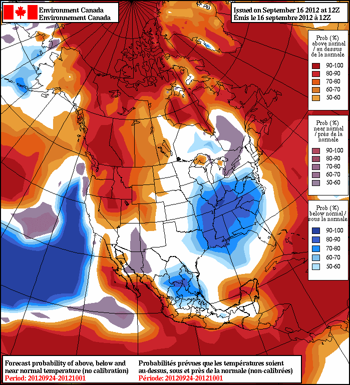
At this point the longe range forecast looks fairly status quo. We will see some temperature fluctuations, making our temperatures feel near normal and average. It will defintely feel fall like with freezing overnight lows.
Friday, September 14, 2012
Half Order of 30C With A Touch Of Below Normal Weather
We will see fairly usual weather for this time of year across Southern Manitoba with a big exception being tomorrow. Why? Well Saturday will hold southerly winds as another upper level ridge moves through our province, that will provide temperatures to rise into the high 20's or even low 30's on Saturday Afternoon. This heat may be the last of the year, all should enjoy!
For the night ahead clear conditions will be in place with light winds out of the south allowing for our temperatures to remain mild and stay around a range where frost will be unlikely. All temperatures will be from the 5 to 9C range in Southern Manitoba, the coolest places will likely be in the parklands out by Dauphin and Wasagaming where you have the highest terrain (which allows for more cooling in those regions).
 |
| The upper ridge has already got going over our area, however this ridge should shift east throughout the day tomorrow letting our temperatures rise into the mid to high 20's. |
 |
| A look at temperatures in Southern Manitoba Tomorrow afternoon with the ridge in place, look at the corresponding temperature legend for your area and add on 13C to figure out the actual temps at the surface. |
Through the day Saturday the upper level ridge I was talking about will move across the province, bringing with it temperatures in the 12C range in SE MB to 20C in SW MB. Expect surface temperatures to peak from 25C to 32C in the southern part of the province. All of this will be ushered in by the southerly winds, if we had downsloping winds from the Southwest then our temperatures would be a lot higher tomorrow. (See the picture on the top for greater detail)
 |
| A powerful cold front will slide through Southern Manitoba tomorrow evening dropping our temperatures down into the mid to high teens for Sunday, get out there and enjoy it while you can! |
However, a powerful cold front will be over the central part of the province on the day Saturday before it drives southwards through Southern Manitoba during the evening (above). This will allow for shower chances and maybe the odd thunderstorm before cooler Arctic air ushers in from the North. Our 850 MB Temperatures will drop to 0C for Sunday which will most likely hold our daytime temperatures to the mid to high teens, under cloudy skies with some possible showers off of the lakes. The cooler weather continue into the week when our 850 MB Temps could drop down to the minus single digits allowing for our temperatures to only reach the low teens during the day, and overnight lows in the mid to low single digits with some places reaching the minuses (yes that cold!). Rain and cloudcover will be possible during the week with the cooler weather. Feel Free to follow me on Twitter for the rest of the weekend for weather updates @SouthMBWeather.
Subscribe to:
Posts (Atom)
Featured Post
Active weekend on the way to Manitoba
Well another weekend of active weather is set to impact southern Manitoba this weekend, thanks to a large trough setting up over western Can...

-
 Hello folks I am back after not being able to write blogs over the last few months. It has been an interesting summer with sleeper setups, ...
 -
 A strong and potent low pressure system will be impacting southern and central Manitoba before another cooldown impacts our region, another...
 -
 Hi everyone, Mike McGregor here. I am here to provide another weather update with details on the next system expected to impact southern an...