Monday, July 30, 2012

July to End Hot and Stormy

After a round of active weather the past couple of days in Southern Manitoba, we can expect a short reprieve with a return to hot and humid weather for the end of July.
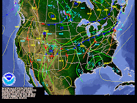
A look at Temperatures for the last day in July at 850MB, just add 13C onto the temperature legend you see in your region on the map.
The month of July will decidedly end just as it started, in the same fashion with the never-ending very warm weather. Sunny Skies and temperatures anywhere from the high twenties to low thirties can be expected for the rest of the day although there may be some cloudcover from general daytime heating. Nothing like what went on Yesterday through the Red River Valley. Winds will make for a comfortable breeze as they blow out of the Northwest, likely blowing some smoke from any ongoing Forest Fires in northern Manitoba southwards into the region. The night ahead will also be fairly nice as winds continue to blow out of the northwest in various locations, any leftover cloudcover will clear as we lose daytime heating. When we lose daytime heating our temperatures cool off so as a result we expect our temperatures to cool down to around 17 degrees tonight in Winnipeg with the outlying regions in the mid teens. 

Tomorrow will be a similar day, although we will have to contend with some thunderstorm activity mainly in Southwest Manitoba and the Western Red River Valley as another system decides to slide through the region. Currently it is looking like some of the storms could end up being pop up scattered thunderstorms in the afternoon and evening hours as daytime heating and the system plays a role in triggering the storms. Given that we will have high amounts of instability in place I cannot rule out the possibility of some severe thunderstorms once they get going. By Mid Evening things could turn into a MCS once the storms bundle and organize themselves, this means that the Red River Valley and eastern Manitoba would be at threat as they would move Eastwards from the point of there origination and create threats of Strong Winds in Excess of 100 km/h, Heavy Rain, Intense Lightning and Large Hail. It is unclear as to what exactly what will happen with the Thunderstorm Complex or MCS at this moment, so I will keep everyone informed about the situation as we get closer to the evening hours Tomorrow. As for tomorrow's Temperatures they will once again feel hot and muggy as we approach or surpass the 30C Degree mark in Manitoba Tomorrow.
The First Couple of days into August are expected to continue to remain hot. High Temperatures on Wednesday and Thursday should reach or surpass 30C with a risk of some severe weather on Wednesday in the Southern Portion Of the province, too far ahead to tell exactly what will go on. I will keep you informed.  Thursday should be sunny and warm as well with little humidity with the Heat Continuing. For Friday we may again be in for another rough ride, several sources have noted that there could be a potential for a thunderstorm outbreak in Manitoba on this day. It is something to watch as well. Comments will be available on Twitter throughout the coming days detailing the severe weather potential.

Saturday, July 21, 2012

Warm Dry Weather To Continue with Thunderstorm Chances

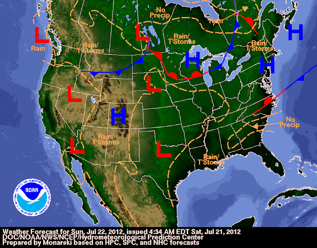
Potential for Thunderstorms exist over The southern Portion of the province on Sunday as a Low pressure System Flattens the ridge

Precipitation will continue to be non existent over Southern Manitoba as the Warm Temperatures persist and the ridge in the jetstream holds it's place over the Province. Mainly sunny Skies daytime temperatures near 30C and nightime t
emperatures in the teens can be expected over the next 24 hours as a few low pressure systems travel through Northern Manitoba, leaving the rainy weather up there. Humidity levels will be lower and more comfortable today and through the rest of the weekend.

As for our precipitation not much can be expected in the region, although there will still be a couple chances but general amounts will be fairly low. The Chances look like they will be on Sunday as a low pressure system moves eastwards out of Saskatchewan through the Interlake Areas and parts of the Red River Valley. A Weather Moment Noted that "Models are suggesting that a band of nocturnal thunderstorms will push into Southern Manitoba on Saturday night and push eastwards before dying around mid-morning." After the storms clear out, nicer weather will be on the menu with sunny skies and beautiful temperatures near 30C.

Next Week Looks to Continue to Be Hot and Sunny with Thunderstorm Chances returning for the middle of the week into the second half of the week. Details on the thunderstorm potential remains unclear as this is still quite far off. I can tell you if a cold front or trough moves through the region with hot and/or humid weather and with extreme instabilty in place then there would be a risk of severe storms. All given that the cap (warm layer of air at the surface) is not too strong. If you are looking for severe weather chances I would bet on Thursday being the day, in Southern Manitoba as NOAA Weather Models Suggest a trough or front of some kind moving through.

Until then enjoy the Nice Weather, I will be away on Holidays and will not be able to update until the 27th of July or later. Follow my weather Links on the side bar of my blog for weather information while I'm away...

Wednesday, July 18, 2012

Even Hotter Weather On The Way

Most of  Southern Manitoba will become extremely hot for the second half of this week, with a slight chance for thunderstorm activity in some areas.
A Powerful upper level ridge will once again build in over our region
A powerful upper ridge will make it's way into Southern Manitoba over the next 12 hours. As a result heat will start cranking up in the southern half of the province and could last 3 days at the most. Tonight winds will shift to the south with most temperatures remaining in the high teens for overnight lows. The southerly wind will help clear the air of any leftover haze or smoke that has been hovering around. That will also aid more solar heating of the atmosphere resulting in cooking temperatures throughout the next 3 days. How hot exactly will it get? Models indicate temperatures of 37 to 40C over areas along the international border, while the temperatures further North towards Highway 1 along and South you can expect temperatures of 34 to 37C. Although I think that 40C might be a bit of a stretch on Thursday considering that it hasn't happened for a long time into history, as well as dewpoints sit in the 20's. With the temperature and the dewpoint combined humidex values will be from 40 to 45C across a widespread portion of the province, some places may even feel closer to 50C. It is near certain that we will see temperatures in the mid to high 30's with humidity values making it feel like the 40's It will definitely be a hot day in the southern half of the province. 

NOAA Wx Map at 00UTC Friday
Although there will be a potential for some thunderstorms on Thursday afternoon through until 6am Friday in Southern Manitoba as a front slides through, if storms fire along the front they may become severe given the heat and humidity. If nothing fires we will just see sunny skies, but then again there is a risk given the hot weather.


As for things on Friday daytime highs should be closer to 30C and not as hot as Thursday's 30C+ Temperatures. So thing's will feel a little more comfortable given less heat and humidity. As For the weekend hot weather to continue with isolated storm chances. 


Get Out There and Cool off with a Slurpee and or a Blizzard!

Friday, July 13, 2012

Hot Weather Expected To Continue For The Weekend

The hot weather will continue for Southern Manitoba through this weekend, but chances for unsettled weather will return for the second half of the weekend, as a trough swings through the region.
 A look at 850 MB Temperatures For Saturday, Tip: Add 13C to the temperature you see on the map to get the actual forecast temperature for your region.


The warm weather will continue tonight, with temperatures hovering near 20C across the southern half of the province. Tomorrow will also be a nice day across the Southern Part of the province with temperatures around the thirty degree mark along with a nice breeze from the west. Due to the heat that will be present tomorrow afternoon there will be a chance for pop up thunderstorms in Regions West of the Red River Valley such as Pilot Mound, Manitou, Brandon,Virden and Melita regions. The storms will mainly be non severe in nature, although they may strengthen to severe limits if they get going. Areas around the Western Red River Valley may also have a chance of seeing storms tomorrow afternoon.
GEM GLB Model for Monday at 12am, notice how precipitation is hovering over the southern portion of the province in a linear manner. That indicates it will either be heavy rainshowers or thunderstorm activity.
Sunday Thunderstorms are Possible


The day on Sunday will be sunny and warm with temperatures reaching the high twenties along with a southeast wind from 15 to 30 km/h before things start turning unsettled in the evening ahead of another trough. It currently appears that there will be a potential for thunderstorms some severe in the evening hours due to the amount of daytime heating that will go on through the afternoon hours on the day Sunday ahead of the trough. Thunderstorm activity will be more likely during the overnight hours on Sunday into Monday as the main trough goes through, with the storms clearing out before morning. Rainfall Accumulations will widely depend on the thunderstorm activity, I would expect that general amounts would be near or around 5mm in most areas. Locally higher in thunderstorms. 

As for the week next week looking like it will be a nice one with temperatures remaining in the high twenties, with a couple chances for thunderstorms.

I will update on Twitter as needed for changes in this forecast.

Wednesday, July 11, 2012

Hot Weather to Continue with More Storms

Southern Manitoba may see the warmest day of the year today as temperatures climb into the mid 30's under the presence of an upper ridge and a somewhat southerly wind. The ridge that is bringing this hot and sunny weather will weaken as several low pressure systems will track through the prairies, bringing us a couple of days of some unsettled weather across the southernmost region of the province.
A look at the 850 MB Temperatures for Wednesday at 6pm
 A nice southwest wind, combined with warmer temperatures under the ridge (22 to 24C at 850MB) today will help Southern Manitoba's temperatures to soar from inbetween 30 and 37C, Winnipeg will get to a Scorching 35C if all regions stick to sunny conditions. Today will definitely be the warmest day of the week, with temperatures returning to around 30C for Thursday and Friday. Overnight lows will be mild with the temperatures only cooling to the high teens or low twenties.
A look at just one of the many systems that will affect us over the next few days, this one will affect us throughout tonight and into tomorrow morning. NMRS CB 40,00 Mean severe storms are likely in large numbers.

A number of low pressure systems are also set to track over the southern portions of the province starting this afternoon/evening, which will bring us the risk of thunderstorms late this afternoon,evening, overnight and throughout the day tomorrow. While forecast storm indicies will be signinficant given the heat  and humidity, a lack of shear will make sure that any storms that form will be the slow moving pulse type storms. They likely will strengthen to severe levels, although they will be range from being hit and miss to widespread. The main threat from any of the storms will be large hail, damaging winds, intense lightning, and heavy rains given there speed and intensity. Tornadoes won't be likely due to the lack of windshear, though if one storms can get strong enough it could end up producing a tornado given the high instability. 

Things will clear up for Friday, with a few hit and miss storms in the South east. Another Storm System will make an appearance on the weekend when we will likely see another possible round of storms.

Monday, July 9, 2012

Welcome Back To Hot And Humid Weather!

The week ahead will be another hot one for people living in Southern Manitoba as another ridge of high pressure starts building into the province. Allowing for another significant heatwave to make headlines in the region.
An area of high pressure will build in this week, allowing for hotter weather to return
The week will start off fairly cool for the heatwave with temperatures in the high twenties to near or above thirty degrees in Southern Manitoba on Monday and on Tuesday. Humidity levels likely will remain low on these day's making conditions feel fairly hot and dry. As we get into the middle of the week on Wednesday temperatures will be in the low to mid thirties, with the humidity levels making it feel like 40C or hotter. As a result various regions could have humidex advisories issued by Environment Canada due to the possible 40C+ humidex temperatures that could be in place. Once we get into the late week period temperatures will be around the 30C mark with humidity values remaining fairly high, making it feel still quite tropical.

Potential Exists for Severe Storms On Wednesday Evening/Night in Winnipeg and The Red River Valley, as there will be 4000 J/Kg of CAPE available in the region during that timeframe. Image is provided by Wundermap from Wunderground

The presence of hot humid weather over the Southern Part of the province this week will allow the atmosphere to become very unstable, giving a risk of thunderstorms on many days. With an area of high pressure over our region it makes it difficult to forecast thunderstorms, as high pressure tends to reduce thunderstorm activity. According to one of the blog's I read today mentioned that "the ridge we will be under won't be that good at reducing thunderstorm activity." So in Turn we may be in for more unstable weather than the usual stable weather we see with high pressure. The best chances for thunderstorm activity in Southern Manitoba appears to be during the second half of the week, from Wednesday towards the weekend and the beginning of next week. During the time frame the atmosphere will be very unstable and there will be some weather systems moving our region that could trigger storms. The potential will exist for storms that could be severe at times due to the instability present in the atmosphere. There also could be slow moving storms at times bringing the threat of heavy rainfall and localized flooding, with upwards of 100mm if one storm sits over the same area for an hour or more. The storms will be scattered to numerous during the second half of the week, although they will not be widespread. I will keep everyone updated on the thunderstorm potential with posts on Wednesday and on Friday of this week.

Overall expect a beautiful week with hot temperatures and sunny conditions, with a few days of thunderstorm activity that we may have to contend with.

Friday, July 6, 2012

A Few More Rounds Of Showers and Storms, Before The Heat Starts Building In!

A few more areas of low pressure and chances of precpitation are expected to move through Southern Manitoba over the next couple of days, as the ridge takes a while longer to build in than first thought.                                                                                                    
A look at the probability of seeing precipitation over 2mm for the time period of July 6th to July the 10th. Chances of precipitation range from 50 to 60% for most of the interlake and the parklands region, while most of Southern Manitoba and the Red River Valley will have a 70 to 80% chance of seeing some kind of precipitation.


The Ridge that was previously forecast to form and move into Southern Manitoba this weekend instead it has decided to wait a while and not form for a couple of days, this means we will be stuck in a more zonal flow through the weekend until the ridge starts building. Although that means we will have a chance at more rain than first thought, though it is great news for areas that haven't received much rainfall in the province.

T-storms will clear out by late eve.  
T-storms will start at Noon
The next likely shot at seeing rainshowers or thunderstorms will come Saturday in the Afternoon and in the Evening as another area of low pressure moves Southeast through the regions of Southern Manitoba. Scattered Showers and Thunderstorms will fire up along this system as it moves through the RRV during the late afternoon early evening hours. There won't be a threat for significant severe weather tomorrow afternoon, as the parameters look to be fairly low. However there may be a few storms in the afternoon that could become severe, if it happens the severe weather will be very short lived.

As for our Temperatures they will remain being in the high twenties for daytime high's along with temperatures in the 15 to 20C mark for overnight lows. The real heat will start by the beginning of the week as the ridge starts building, temperatures will rise into the mid to high 30's by the end of next week and into next weekend giving us a great shot of summerlike weather.

Wednesday, July 4, 2012

A Summary of Last Night's Storms; Warmer and Drier Weather On The Way

It was a crazy Night In Southern Manitoba last night, prompting Environment Canada to issue numerous watches and Warnings, Yet this is a view of what caused all of the trouble.
A view of the MCS Complex at it's most intense at around 13:00 UTC.
Some Regions Of Southern Manitoba saw a stormy start to the day as an MCS tracked over the region. The MCS formed around midnight last night in SW Manitoba after a scattered line of storms bunched together from Saskatchewan, it then got itself together and travelled through Southwest Manitoba and the Red River Valley. It Generated Intense Lightning and reports of winds in excess of 50km/h and rainfall rates of 125-250 mm/hr as it moved through. Just have a look at the rainfall totals from some of the locations that received heavy rainfall, especially in the Turtle Mountain region.

Boissevain.... 102 mm
Dunrea ....... 91 mm
Killarney .... 83 mm
Minto ........ 69 mm
Elgin ........ 69 mm

CPC Temperature Forecast for the next 7 to 14 days, the large area of red over Central Canada indicates there is a 70 to 80% chance of seeing above Normal Temperatures. That would be anywhere from 26 to 38C.
This was to be the last bout of rain for at least another 14 days, as another subtropical ridge of high pressure starts building northwards into the Canadian Prairies. This will push plenty of heat and some humidity into Southern Manitoba. Daytime high's could stay in the high 20's to mid 30's through much of the 14 day period, with the odd system bringing some light rainfall but nothing in high amounts. Hopefully this hot stretch will be short lived, we do not need another drought.

Anyways, enjoy the hot weather it is a part of the Summer Tradition.

Featured Post

Happy New Year, Significant Winds Likely with Blizzard Conditions this weekend. Cooler weather arriving next week.

 Everyone welcome back to a new year in the weather scene hello everyone mike mcgregor here returning for the first post of 2025 and we'...